
| Нo | Название | Описание |
|---|---|---|
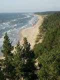 |
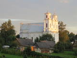
Construction on the lighthouse was initially completed in 1879. The structure suffered damage during both world wars and was restored several times. The structure is 19 metres high and stands 46.5 metres above the wavy sea. Here you will find one of the loveliest views of the shores of the Baltic Sea.
|
|
 |
Gebaut in 1610, später umgebaut. Eins der hervorragenden Gebäuden Litauens der Renaissance. Eine Ausstellung der Kunstakademie Vilnius. Ein Aussichtsturm. |
|
 |
Ziemciešu audzētava „Puķu lauki” ir ģimenes uzņēmums, kurā audzē un piedāvā dekoratīvos stādus. Saimniecība ir specializējusies konkrētu augu grupu audzēšanā. Tās laukos bagātīgi zeļ ziemcietes, graudzāles (zāļveida ziemcietes) un dažādas cirpto bukšu formas. Turklāt, šejienes augu šķirnes ir pielāgotas mūsu klimatiskajiem apstākļiem. Apmeklētāji var izstaigāt skaisti iekopto un ainavisko paraugdārzu, kā arī iegādāties stādus plastmasas konteineros visas sezonas garumā. |
|
 |
Находится на 72 км шоссе Рига - Лиепая (A9). Предлагают музыкальные вечера. Латышская кухня: Видземский салаты, селедка с творогом и сметаной, серый горох с салом, тушеная капуста с колбасками, голубцы, картофельные блины, хлебный суп, слойка из черного хлеба. Особое блюдо: «4 ветра» - свинина с квашеной капустой и картофелем на горячей сковороде. |
|
 |
В «Риекстини» Нереты шесть лет своего детства провел выдающийся латвийский писатель и художник Янис Яунсудрабиньш (1877 - 1962). Я. Яунсудрабиньш родился в семье слуг «Кродзини» Нереты, а в «Риекстини» с матерью переехал после смерти отца. Люди, жившие в «Риекстини», стали прототипами героев его «Белой книги», в которой этот дом называют «Наш дом». В память о Я. Яунсудрабине в 1967 году в Риекстини был открыт музей, который находится в аутентичном хуторе Селии со своим особым духом и ароматом. Можно осмотреть жилой дом, амбар и каретник. В яблоневом саду «Риекстини» есть столетние и более старые яблони. На кладбище Кишку (у дороги Вецумниеки - Илукстес), расположенном неподалеку, похоронены члены семьи Яунсудрабиней и перезахоронен сам Я. Яунсудрабиньш. В Неретском краю сохранилось много хуторов и имен собственных - названий холмов, рек и других мест, упомянутых в «Белой книге» Я. Яунсудрабиня. |
|
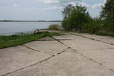 |
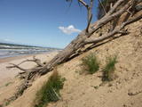
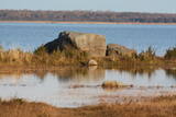
The hydroplane airfield is on the eastern shore of Lake Durbe, not far from Līguti. It was built between 1939 and 1941. During the Soviet era, the 43rd aviation escadrille was located here, and it had 13 MBR-2 hydroplanes. All that’s left today are the cement sheets on the shore of the lake. You can look at the site itself.
|
|
 |
Самое большое населенное место на юго-востоке Латвии, которое с юга омывается водами Даугавы, одновременно являющейся Латвийско-Белорусской границей. Граница государств проходит по середине реки. Пиедруя состоит из двух частей – Пиедруя и Александрова, которые разделяет центральная улица (дорога V 631). Пиедруя образовалась как «заречная» территория существующего на левом берегу Даугавы города Друя. Обе части в 17-м веке были собственностью рода магнатов Сапег Великого княжества Литовского. Малоэтажная застройка Друи с разрушенной церковью хорошо просматривается с берега Пиедруи. Пиедрую и ее окрестности стоит обойти пешком, так как малоэтажная деревянная застройка местами напоминает виденное в этнографических музеях под открытым небом. Пиедруя благоустроена, между двумя церквями разбит живописный сад. Со значимыми объектами – двумя церквями и Даугавским камнем знакомит Пиедруйская тропа. В Александрова находится гостиница «Пиедруя», предлагающая особый туристический продукт – вечеринки в латгальском, русском и белорусском стилях. Перед отправлением в Пиедрую необходимо оформить разрешение для пребывания на приграничной территории. Пост пограничного контроля находится в Пиедруе, на берегу Даугавы, где еще сравнительно недавно действовала одна из Даугавских переправ. |
|
 |
Mākoņkalna pagasta "Itkaču mājās" ir iespēja ieturēt maltīti- plānās pankūkas ar dažādiem pildījumiem, kartupeļu pankūkas, dārzeņu sautējumu. Iespēja apciemot trušus, pabarot tos ,paglāstīt un paturēt sev klēpī. Pieejami saimnieku veidoti suvenīri. |
|
 |
Легендарный ресторан Halinga расположен на обочине шоссе Via Baltica в получасе езды из Пярну в сторону Таллина. Ресторан гостеприимно открывает свои двери и для спешащих водителей, и для организации мероприятий, в том числе рассчитанных на большие группы. Здесь стараются использовать как можно больше местных продуктов, а еду готовят по местным рецептам. |
|
 |
Согласно древней истории, в период первой церкви, когда во время шторма проходила церковная служба, в море у старого кладбища тонул корабль, и священник с членами прихода – добровольцами в весельной лодке отправился спасать команду. Часть команды удалось спасти, остальных выбросило на берег. В честь этой с одной стороны трагической, с другой – счастливой развязки событий, капитан корабля назвал это место Феликсбергом (счастливым берегом). Это название позднее было заменено на Пилсберг, нынешнее название - Юркалне - населенный пункт получил в 1925 году. |
|
 |
Guests to the Dīķīši homestead in the Amata Parish will be greeted by several Samoyed dogs and intelligent little donkeys that will bring the guests to a place for glamping next to the pond. You can hike down two trails of different lengths of enjoy the opportunities that exist when Latvians share places where they find mushrooms and berries. A special adventure is creating artworks from natural materials that have been collected in the forest. The accommodations are appropriate for people who use a wheelchair. The lavatory has been adapted to the needs of such people, as well. People who are interested in cultural history can tour a collection of Latvian folk costumes, trying them on and organising their own photo session. People who enjoy extreme feelings will enjoy a ride on a quadricycle. If you love to go fishing, bring your own inventory. We organise fire rituals for birthdays and family celebrations, and we’ll also offer soup that has been cooked on a campfire, as well as a master class in cheesemaking. |
|
 |
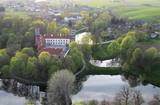
Усадьба «Анцес» построена как отцовский подарок сыну Ульрихаму Иоганну фон Беру. После 1766 года здание усадьбы было перестроено и богато украшено. в этот период здание было двухэтажным, с большими окнами и паркетными полами. В 10-е годы 19-го века в усадьбе размещаются французские солдаты и наносят зданию значительные повреждения. Поэтому чуть позже второй этаж был снесен и, после проведения капитального ремонта, усадьба приспособлена под квартиры управляющего и чиновников. В 1920-м году усадьба «Анцес» была отчуждена у ее последнего владельца Георга Бера и становится государственным имуществом. |
|
 |
Чудская баржа - специально для условий Чудского озера и реки Эмайыги созданное торговое парусное судно, которые, как известно, строили уже в 14-ом веке. В 2006-ом году после полувекового перерыва опять спустили на Эмайыги баржу, которая получила название "Jõmmu". Баржевая компания Эмайыги организует различные поездки и природные путешествия по Эмайыги и Чудскому озеру."Jõmmu" ожидает и маленьких фанатов водного дела знакомиться с традиционным ремеслом и кораблестроением. |
|
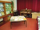 |
Музей Берзгальской волости был основан в 1988 году. В
музее расположена мемориальная комната писателя Антона
Рупайниса (1906 – 1976), экспозиция об истории волости, о
знаменитых людях, культурно-исторических традициях.
Время работы: Пн.– П.: 9.00 – 12.00,13.00 – 17.00, Сб., Воскр.: по договоренности |
|
 1 день
|
Tūrisma gide Ineta Jansone piedāvā ekskursijas grupām gar Kaņiera ezeru, iepazīstinot ar putniem, kuri mīt tā tuvumā. Kaņiera ezers ir vieta, kur migrācijas laikā apmetas daudzi tūkstoši ūdensputnu. Ezerā un tā apkārtnē sastopamas vairāk nekā 200 putnu sugu. Putnu vērotāju ērtībām vienā no Kaņiera ezera pussalām uzcelts putnu vērošanas tornis. Netālu no putnu vērošanas torņa izveidota koka laipa uz pontoniem, kura stiepjas cauri niedrāju audzei. Kaņiera ezers izceļas ar lielu daudzums zivju – tajā konstatētas gandrīz 20 zivju sugu. Izsens zvejnieku ciems - Lapmežciems atrodas skaistā vietā uz šauras zemes strēles starp Kaņiera ezeru un Rīgas jūras līci. Lapmežciemā izveidots zvejnieku muzejs, kuru var apmeklēt ekskursijas laikā, kā arī nobaudīt svaigi kūpinātas zivis. |
|
 |
Neliela ziepju un dažādu citu ķermeņa kopšanas produktu darbnīca. Pašu audzētos un saimniecības pļavās ievāktos ārstniecības augus iestrādā ziepēs un skrubjos, gatavo no tiem izvilkumus augu eļļās, kurus iekļauj lūpu balzamos un krēmos. Ziepes tiek vārītas tā, kā to darīja agrāk - no sārma un taukvielām. Apmeklētājiem iespēja ielūkoties “Ezervanna” mazajā darbnīcā, paklausīties stāstā par ziepju vārīšanu, iemēģināt roku un radošumu skrubju gatavošanā vai “pamīcīties” ar ziepju veidojamo masu un pagatavot savu ziepju gabalu. |
|
 |
15.janvāra naktī Kalpaka bataljons izcīnīja pirmo kauju pie Lielauces, atvairot sarkano uzbrukumu. Tā bija pirmā nozīmīgā Kalpaka bataljona kauja, kad uzvara karavīriem deva īpaši spēcīgu morālu stimulu. 1934. gada 19. augustā pie Lielauces luterāņu baznīcas atklāja pelēkā granītā veidoto pieminekli Oskara Kalpaka bataljona pirmās kaujas vietā. Piemiņas zīme veidota pēc arhitekta P. Dreimaņa meta. Lielauces kauja notika 1919. gada naktī no 15. uz 16. janvāri starp kalpakiešu Cēsu un Virsnieku rotu no vienas puses un 2. strēlnieku pulka karavīriem. 50. gadu sākumā piemineklis tika iznīcināts, bet atjaunots 1991. gadā |
|
 |
This is a part of Latvia in which various manifestations related to layers of earth made up of water-soluble lime can be found. The most unusual elements here are Lake Vecezers and Lake Linezers. The water of the latter lake has flowed underground several times over the last few decades, with the remaining lake hole as much as nine metres deep. No one can fully explain how this happens. A tourist trail encircles Lake Linezers.
|
|
 |
Trīs lielāka izmēra laukakmeņi – aizsargājami dabas pieminekļi, kas atrodas Matsalu līča krastā starp Sāstnas (Saastna) un Metskjulas (Metsküla) ciemiem. Tuvējā ceļa malā ir izvietots informācijas stends un norādes, bet līdz akmeņiem var nokļūt pa iezīmētu taku. Pēc kāda tautas nostāsta, lielas vētras laikā, kas notikusi Jaungada naktī, lielais akmens sašķēlies trīs daļās. No tā arī cēlies vietvārds. Apkārtnē redzamās pļavas ir nozīmīga daudzu augu sugu dzīves vide un svarīga putnu ligzdošanas un atpūtas vieta. Šī iemesla dēļ taku drīkst apmeklēt tikai no 1. jūlija līdz septembra beigām. Akmeņi ir arī labi redzami no minētā ceļa. Tie ar ledāju atceļojuši no Turku (Somija) apkārtnes. |
|
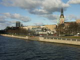 |
The classical skyline of Old Rīga can be enjoyed from several locations – Mūkusalas Street, between the railroad bridge and the stone bridge, from the stone bridge, from the A-B dam, from the grounds of the central office of the Swedbank bank, from the Vanšu bridge, and from the Ballast Dam at Ķīpsala. You can hike or bike from location to location. During the summer, little ships cruise up and down the Daugava to offer different views.
|
|


