
| Нo | Название | Описание |
|---|---|---|
 |
Кестери – родной дом деятеля ливской культуры и органиста Карлиса Сталте
(1870 -1947).
|
|
 |
Находится на обочине шоссе Рига – Вентспилс (A10). Летом работает открытая терраса. Латышская кухня: Салат из говяжьего языка, холодный суп, бульон с фрикадельками, «крестьяньчик», свиные ребрышки, картофельные и тонкие блинчики, мусс. Особое блюдо: Харчо от кафе «У Яниса». |
|
 3 дня
|
The tour starts at Jaunmokas Castle estate, where you will also find the Forest Museum. The pride of the castle is its unique painted tile stove (beginning of the 20th century) made of 130 painted tiles featuring 50 different views of the cities Rīga and Jūrmala. The Forest Trails runs along smaller tracks through the Austrumkursa Uplands, the valley of the river Slocene, along Lake Sekļa and Lake Jumprava to finally reach the town of Tukums. Well, the town takes pride in its pots, planters and flower beds with blooming roses along its streets. Next, the route meanders through forests to the demanding hillock of Milzkalns and Lake Valguma, where you will find the barefoot trail and a secluded art space within the woods. The Forest Trail continues to make a stopover at the Ķemeri National Park. The park is dedicated to protection of wetlands, since it is home to one of the largest marshlands of Latvia – the Great Ķemeri bog. As to the town – Ķemeri – it is the former balneological and sulphur springs resort. The tour ends in the village of Bigauņciems, where the Forest Trail joins with the Baltic Coastal Hiking Route (E9 European long distance path). Optionally, one can take a detour along the Lake Sloka trail with its bird-watching tower or pay a visit to the “Forest House” – the visitor’s centre of the Ķemeri National Park. |
|
 1 день
|
After passing through Sigulda, the Forest Trail follows the River Vējupīte to Paradīzes Hill, where a steep staircase leads down into the ancient valley of the River Gauja and the ravine of the River Vējupīte. It continues to wind down smaller paths through meadows, crossing small rivers whose banks reveal sandstone outcrops. The last six kilometres of this section follow a smaller path down the Līgatne Nature Trails. You can see local wildlife animals and birds on this 5.5 km long trail. Further on the Forest Trail moves up the hills of the ancient valley of the River Gauja, before descending back down into the deep ravine of the River Līgatne, where the village of the former Līgatne paper mill is located. You can explore this attractive small village, visit the Līgatne spoon factory, winery and Līgatne caves. There is also the Līgatne Net Park with 4-7 m high net labyrinths among the treetops. This part of the Forest Trail and Gauja National Park is characterised by a gradual transition from diverse, deciduous forests (ash, grey alder, oak, birch, linden) to coniferous stands. |
|
 |
This is a family company in the Madona Administrative District, which offers natural herbal teas and spices. All of the ingredients come from
|
|
 |
The restoration of Kau Manor, which was originally constructed before 1241, was inspired by the colourful history of the manor, and the imagination makes it stand out from the other manors. Kau Manor has won the 2016 World Boutique Hotel Award in the category of the World’s Most Inspired Design Hotel. |
|
 |
Ārkārtīgi ainaviska teritorija Augšzemes augstienes centrālajā daļā ar vairākiem ezeriem - Medumu, Lielo un Mazo Ilgas, Šķirsteņu un dažām mazākām ūdenstilpēm. Medumu ezera salām ir dabas lieguma statuss. Teritoriju šķērso vairāki grantēti ceļi, no kuriem dažviet paveras brīnišķīgas, bet nelabiekārtotas skatu vietas. Teritorijā atrodas Medumu katoļu baznīca. Piemērota teritorija dažādu aktīvā tūrisma veidu attīstībai. Dabas parks ietilpst Augšzemes aizsargājamo ainavu apvidū. |
|
 |
Озеро Разна (57,8 кв.км), называемое народом морем Латгалии, по
вместимости воды самое большое в Латвии и находится на возвышенности Латгалии, на пригорках
Разнава. В живописной окрестности озера поднимаются самые высокие вершины Латгалии и латгальские
городища. На берегах озера находятся излюбленные места отдыха горожан. Чтобы уберечь и сохранить
уникальный комплекс природы, создан Национальный парк Разна, а территория включена в сеть Natura
2000 защищаемых территорий Европейского союза. В озере 10 островов, 2 залива. Уровень воды озера –
163,8 м над уровнем моря.
|
|
 |
Пивовар ждет посетителей в красивом уголке, окруженном лесом, озерами и курганами, титулованном Швейцарией Литвы. Пиво «Чижо», которое является легким, нефильтрованным и живым, готовят по традициям прадедов, с мёдом лесных пчёл. Пивовар унаследовал не только рецептуру, но и оборудование, поэтому в своей усадьбе основал экспозицию старинных инструментов для изготовления пива. Посетителей приглашают на экскурсии и дегустации. |
|
 |
Dabas liegumā "Lielie Kangari" atrodas 33 metrus augsts skatu tornis, kura virsotnē atrodas platforma, no kuras paveras skats uz Kangaru ezeru un Lielkangaru purvu. Dabas liegumā izbūvēta arī nepilnu divu kilometru gara pastaigu taka ar tiltiņiem un skatu platformu pie ezera. Takas sākumā izvietotais veselības maršruts ikvienu apmeklētāju aicina kārtīgi izvingroties un izkustēties. Apmeklētāju informēšanai un izglītošanai visas takas garumā izvietoti arī informatīvie stendi ar fotogrāfijām, kas apvieno varenu stāstu un teiku kopumu par notikumiem, vietām, tēliem un parādībām dažādās apkārtnes vietās. |
|
|
|
Einer der ausgeprägten Kaps der lettischen Küste mit Niederungsauen und einem in 1875 gebauten Leuchtturm. |
|
 10 дней
|
Во время этого путешествия вы посетите как мастерские ремесленников, так и хозяйства по разведению лошадей, а также различные производства деревенских продуктов, где старинным навыкам нашлось современное применение. Первая остановка - Икшкиле, где уже в самом начале путешествия вы посетите погреб вина из березового сока и попробуете игристое вино из березового сока. В Скривери позвольте удивить себя превращениям молока - здесь, в уютном кафе на главной улице города, готовят великолепное домашнее мороженое как со вкусом клубники, так и со вкусом анчоусов и хрена. В Кокнесе вы сможете пополнить свой гардероб новым кожаным ремнем, сумкой или стильным украшением из кожи. В хозяйстве по выращиванию конопли пройдет небольшая экскурсия и дегустация деликатесов из конопли. Работы мастеров латгальской черной керамики хорошо впишутся и в современные интерьеры. В Аглонском музее хлеба посетителям будет предложена возможность самим испечь буханку хлеба, а во время посещения следующего хозяйства его можно будет дополнить вкусным сыром, который сделан из молока пасущейся на воле Латвийской бурой коровы. Последняя остановка на латвийской стороне - Даугавпилс, с Арт-центром имени всемирно известного абстракциониста Марка Ротко и Даугавпилсской крепостью 19-го века - впечатляющей военной постройкой - как наиболее популярными достопримечательностями. Затем дорога ведет в Литву, где запланировано посещение нескольких традиционных сельских хозяйств. В усадьбе Ильзенберга (Ilzenbergo Dvaras) обустроено биодинамическое хозяйство. Вы сможете попробовать национальное литовское кондитерское изделие – торт шакотис, осмотрите литовский город Аникщяй (Anyksciai), который предлагает прогулочную тропу над верхушками деревьев. В Музее лошадей представлены старинные орудия труда и техника. В продолжении предусмотрено посещение хозяйств, которые знакомят с традиционной литовской кухней и гончарным ремеслом. В коневодческом хозяйстве в Дубингяе (Dubingiai) можно прокатиться верхом на лошади по манежу. В завершении путешествия вы осмотрите уникальный Тракайский замок (14-15 век) и Вильнюс. |
|
 |
Находится~ в 4 км, не доезжая до Априки (установлен указатель) – Гибортское кладбище. Слепой Индрикис (1783 – 1828) был латышом, опубликовавшим первое собрание стихов на латышском языке (1806 г.). Индрикис был слепым с 5-летнего возраста и был необразован. Его стихи записал и издал в упомянутом году священник Априкского прихода K. Г. Элверфелдс. На кладбище установлен памятный камень (1935 г.) и созданное Вилнисом Титансом «Аустрас кокс» с надписью шрифтом Брайля. |
|
 5 дней
|
Балтийский путь был уникальной акцией не только в масштабе Балтии, но и всей Европы и даже мира. Никогда еще такого не было, что жители трех государств образовали живую цепь, которая соединила столицы государств – Вильнюс, Ригу и Таллин. Историческое событие произошло вечером 23 августа 1989 года, оно объединило примерно два миллиона человек. Его целью было напомнить события 50-и летней давности – подписание пакта Молотова-Ребентропа, в результате чего две державы того времени – Германия и СССР разделили сферы влияния в Европе накануне Второй мировой войны, а страны Балтии потеряли свою независимость. |
|
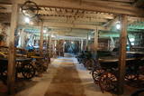 |
Музей гужевых повозок расположен на скотоводческой мызе Пилькусе. Экспонатами являются телеги, одноколки, сани, а также их снаряжение (дуги, оглобли, бубенцы, санные одеяла и специальные болотоступы для лошадей). Среди экспонатов есть также тачанка, карета скорой помощи и пожарная карета.Самыми яркими экспонатами являются карета и коляска, еще имеется большое количество сельскохозяйственных орудий труда. Есть что посмотреть, интересных экспонатов с избытком. |
|
 |
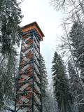
Based on the tower of a former Soviet army radar installation, there is an 18-metre viewing tower at the Southern breakwater of Ventspils (Medņu Street) today. The tower offers a good view of the port territory, with the sea gate at the mouth of the Venta River and the city beach. Binoculars are available at the tower. It is worth walking down the Southern breakwater to get a better look at the sea.
|
|
 |
Целью туристического центра Лахемаа является пропаганда природосберегающего образа жизни и умения жить в природе-сажаются деревья и развешиваются домики для птиц. Для интересующихся - походы на каноэ по Лахемааскому национальному парку, походы по болоту и стрельбу из лука и арбалета. Приятно провести время можно в каминном зале и сауне с гидромассажной ванной. |
|
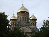 |
Собор построен в византийском стиле в 1900 - 1903 гг. как военный гарнизонный приход, (в честь защитника всех моряков Святого Николая), в освящении которого участвовал император Николай II. Роскошное здание было разграблено немцами во время Первой мировой войны. Во время Первой независимой Латвийской Республики кафедральный собор действовал как храм Лиепайского гарнизона. Советская армия использовала помещения собора в качестве кинотеатра, склада, спортивного клуба для матросов. Сохранились истории о том, что советские солдаты отламывали от икон кусочки золотой мозаики. Теперь в церкви - православный приход. В строительстве кафедрального собора использована уникальная беспрерывная технология бетонирования, поэтому конструкции постройки не имеют опорных колонн, и тяжесть конструкций приходится только на стены здания. Стены удерживаются четырьмя перекрестными сводами арок. В настоящее время это самый высокий православный кафедральный собор в Латвии. |
|
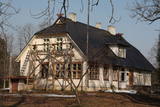 |
До наших дней сохранилось несколько строений Шлитерского хутора: дом прислуги (конец XIX в.), насосная (середина XIX в.) и коптильня (середина XIX в.), хлев и др. В 1936 году здесь построили здание лесничества (отреставрировано в 2010 г.), в которое с конца 2009 года вернулась из Дундаги администрация Слитерского национального парка - теперь Курземская региональная администрация Управления охраны природы. Напротив здания администрации растут два тиса, а разросшийся плющ обвил северную сторону стены дома прислуги. Тис обыкновенный и Балтийский плющ являются своего рода символами Шлитере, которые здесь можно увидеть и сфотографировать в одном месте, не тревожа их в естественной среде обитания. В насосной со времен Шлитерского фольварка, сохранился уникальный в масштабе Латвии колодец глубиной 34 метра (почти как высота всех Шлитерских Синих гор!), который работал до семидесятых годов ХХ столетия и снабжал водой комплекс лесничества. Каменный фрагмент обшивки колодца виднеется как часть стены насосной. Комплекс фольварка опоясывают небольшие фрагменты парка с аллеей внушительных ясеней. В свое время в одном из помещений здания лесничества ночевал после охоты K. Ульманис. |
|
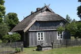 |
Один из двух в Латвии рыбацких поселков (второй Кошрагс), который до сегодняшнего времени (насколько это возможно) сохранил дыхание аутентичности. Здесь находится филиал Латвийского Этнографического музея под открытым небом «Витолниеки» с древним рыбацким двором, лодками и предметами быта, с которыми можно ознакомиться в сопровождении гида. Сейчас в поселке ведется активное строительство современных зданий, поэтому с каждым днем он теряет свою первозданность. Находитсяв Папском природном парке . |
|


