
| Nr | Name | Beschreibung |
|---|---|---|
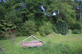 |
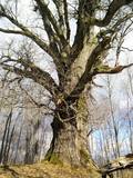
Atrodas ~ 1,5 km ziemeļos no Krāslavas centra, Jāņupītes krastā (ir norāde). Pēc atsevišķiem savrupatradumiem var spriest, ka pilskalns apdzīvots laikā no I g. t. pr. Kristus līdz vēlajam dzelzs laikmetam. Domājams, ka savu nosaukumu tas ieguvis šeit sastopamo mālu dēļ. Nelielas mālu ieguves vietas pilskalna nogāzēs ir redzamas arī šodien. Saglabājies nostāsts, ka grāfs Plāters šeit apraudājis savu sievu, kuru pats neuzticības dēļ licis iemūrēt pazemē. |
|
 |
Darbnīcā tiek izgatavoti personalizēti pulksteņi un dažādi dizaina priekšmeti no koka, kā arī piedāvātas kokapstrādes meistarklases vai klātbūšana dažādos materiāla pirmsapstrādes vai finiša apstrādes procesos. Tāpat iespējama ekskursija pa darbnīcu un koku sugu atpazīšanas viktorīna. |
|
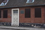 |
Находится на ул. Кунгу, д. 24.Одно из старейших зданий города - деревянный сруб с черепичной крышей, построенный во второй половине XVII века и прозванный в народе гостиницей мадам Хойер. Здесь в 1697 году во время путешествия «Великого посольства» в западную Европу останавливался (инкогнито) русский царь Петр I. Находящееся по соседству здание на ул. Кунгу, д. 26, является вторым старейшим жилым зданием Лиепаи (1699 г.) – жилой дом бургомистра города. Во время Северной войны здесь останавливался король Швеции Карл XII. Оба здания подлежат осмотру только снаружи. |
|
 |
This trail's purpose lies on the fact that herbal therapy is the oldest known system of medicine. Being outside, in fresh air, in nature affects our health positively. While hiking with a phytotherapist you will get to know more about the nature's wild herbs that can help our livelihood and also do some light exercises. If you want, you not can only walk the trail but also relax in a sauna or/and visit a workshop. |
|
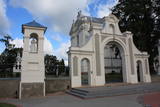 |
Das beindruckende Denkmal des lettgalischen Barocks. Gebaut in der Periode von 1755 bis 1767 nach dem Projekt des italienischen Architekten A. Parako. Eine Kapelle mit der Reliquie vom St. Donatus, dem Beschützer von Krāslava. |
|
 |
Reta galda vīnogu kolekcija un degustācija, ainaviska dārza apskate un stāstījums par ķirbjaugu, čilli un tomātu šķirņu kolekciju. Kolekcijā ir 120 šķirņu tomātu, 20 šķirņu paprikas un aso piparu, 140 šķirņu ķirbjaugu. Degustācijas galds - sukādes, čilli, interesanti ievārījumi un pašu fermentētas tējas. |
|
 |
MIGLA ir mazā alus darītava, tas ir sens saimnieka sapnis, kurš realizējies, spēkus apvienojot kopā ar jaunāko meitu. Alus garšu meklēšanā, receptūru izstrādē, kā arī novērtēšanā piedalās visa ģimene, kur īpašas alus someljē īpašības piemīt vecākajai meitai. Apvienojot visas ģimenes stiprās puses - darītāju, runātāju un garšu pazinēju un dizaina ekspertu, tapis MIGLAS alus, kas šobrīd piedzīvo savus pirmos soļus alus pasaulē un cer iepriecināt ne vienu vien alus baudītāju! Lielu daļu alus darīšanas tiek veikta ar rokām, svērti un malti graudi, rēķināts ideālais apiņu un graudu daudzums, tiek liets, pārliets un skalots. Darītava laprāt uzņem viesus degustācijām, kurās piedāvā ne tikai nogaršot alu, bet arī cienā ar pašceptu maizi un cepumiem, kā arī iepazīstina ar alus darīšanas procesu un vēsturisko Uzvaras Līdumu, kurā atrodas alus darītava. Mazais brūzis atrodas vienviet ar Ķiploku pasauli - otru ģimenes aizraušanos, tāpēc uzreiz var apskatīt divas saimniecības. |
|
 |
The cafe Piladzitis is situated in Kuldiga next to the Venta rapid and an old brick bridge in Parventa. Piladzitis offers substantial and Latvian dishes. The cafe’s working hours: 9:00 – 20:00, no days off |
|
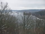 |
At the Aizkraukle Lutheran church along the upper part of the shores of the ancient Daugava River valley, there is a bit of an old road from which one of the most beautiful views of the central section of the river can be seen, particularly when the trees are bare. Approximately one kilometre to the North-west is the Aizkraukle castle hill, which offers a no less impressive view.
|
|
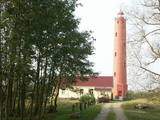 |
Leuchtturm von Akmeņrags wurde auch in der Zeit der Sowjetunion für die Gewährleistung der Meeresnavigation genutzt. Zur Zeit befindet sich der Leuchtturm im Besitz von Meeresadministration Lettlands und ist für Interessenten nur von Außenseite zugänglich.
|
|
 |
Getliņu ekoloģiskais poligons ir Latvijā unikāls piemērs ekoloģiski saderīgu darbības virzienu ieviešanai. Tā energobloka saražotais siltums tiek izmantots siltumnīcu apsildei, kas nodrošina ideālu vidi lauksaimnieciskai ražošanai (puķes un tomāti - lielaugļu tomāti, tumšsarkanie tomāti, aveņkrāsas ķekartomāti) gada aukstajos mēnešos. Poligona teritoriju (zālāju) nogana ar aitu ganāmpulka palīdzību. |
|
 |
Dieses Schutzgebiet befindet sich an der Ostküste des Ķīšezers – Sees. Hier sind die Habitats von größter Bedeutung – Auen und andere Wiesen, Dünen, das Aquatorium des Ķīšezers – Sees, die Küste, Eichenwälder, Schwarzerlen und andere Bäume und viele riesige Eichenbäume kann man im Schutzgebiet und jenseits seiner Grenze finden. Der Burgberg von Bulduri, der der wichtigste alte Burgberg im Rigaer Gebiet ist, befindet sich am südlichen Ende der Lieupsala – Insel. An der Grenze des Schutzgebietes befindet sich eine Zweigstelle des Lettischen Ethnographischen Freilichtmuseums, die unter “Vārnas” bekannt ist.
|
|
 |
Das Restaurant befindet sich in der Altstadt von Liepaja, in einem restaurierten Gebäude, wo der Postbote Arvids gelebt und seine Tage verbracht haben soll. Das Gebäude hat Auszeichnungen für seine Innenausstattung erhalten. In der Speisekarte ist attraktiv das Leben des Postboten Arvids geschildert worden, dem Sie glauben oder nicht glauben können... Lettische Küche: Kalte Suppe, Ampfersuppe, im Ofen gebackener Kabeljau, Wels- und Flunderfilet, gegrillte Schweinerippen, Graupengrütze in Speck- und Zwiebelsoße, Kartoffelpfannkuchen, dünne Pfannkuchen, geschichtetes Roggenbrot-Dessert. Das besondere Gericht: Liepājas menciņi (Kabeljau von Liejapa) geräucherter Kabeljau mit Kartoffeln, Zwiebeln und Dillen in einem Keramiktopf. |
|
 |
Café mit freier Atmosphäre in Ādaži. Die Terrasse bietet einen weiten Blick auf die Ufer des Flusses Vējupe und wunderschöne Sonnenuntergänge. Hier wird moderne Weltküche angeboten - Salate, Snacks, Suppen, reichhaltige Hauptgerichte, Burger und alkoholfreie Getränke. |
|
 |
Hier kann man eine Dampflokomobile, eine Dreschmaschine und einen Bauernhof aus dem 19. Jh. besichtigen, der einem durchschnittlich wohlhabenden Bauer in der Region Sēlija gehörte und auf dem sich ein Wohnhaus mit einem Mantelschornstein, zwei Kornkammern, eine Getreidedarre, eine Sauna, eine Windmühle und eine Schmiede befinden. Touristengruppen werden hier thematische Veranstaltungen angeboten: Handwerksarbeiten auf dem Hof der Selen, Wenn der Honig auf der Zunge taut und Heirat auf dem Hof der Selen. |
|
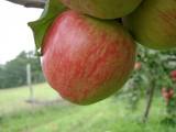 |
Der Hof befindet sich an einem sehr schönen Ort am Westhang der Hügel um Talsi, von wo aus sich die Sicht nach Talsi und Umgebung eröffnet. Hier werden Äpfel angebaut und verarbeitet (getrocknet, Apfelchips, Saft). Auf die Gäste wartet eine Führung, bei der man die Produkte verkosten und erwerben kann. Der Hof befindet sich in einem besonders geschützten Gebiet, im Naturschutzpark Hügelland von Talsi. Im Sommer kann man hier auch mit Zelt campen. Die Besucher können zusehen, wie der Baumschnitt erfolgt. Aus den Gärten der Höfe in diesem Hügelland wurde eine Vielzahl an Apfelsorten gesammelt, woraus die Hausherrin die Kollektion einheimischer Äpfel erstellt und weiter vervollkommnet. Am Hof gibt es eine Schautafel, die mit dem NSG bekanntmacht. |
|
 |
Aptuveni 2km garā Ķirbižu meža izziņas taka izveidota apļveidā gar Vitrupes abiem krastiem. Visā takas garumā var mācīties atpazīt Latvijas mežu raksturīgākos kokus, krūmus un augus. Šeit var aplūkot arī Vālodzes dižozolu (6.5 m). Upes labajā krastā, pie tā sauktā vīna pagrabiņa un kreisajā krastā apmēram 200 m no takas sākuma pie Meža muzeja, atklājas ainaviski skati uz ieleju un Vitrupi. |
|
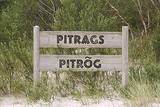 |
Zum ersten Mal wurde das Dorf im Jahr 1582 urkundlich erwähnt. Auf den Sandbänken in der Nähe von Pitrags liegen viele versunkene Schiffe. Im Jahr 1826 wurden in Pitrags elf Bauernhöfe und 190 Einwohner registriert. Um die Mitte des 19. Jh. wurde hier ein Wirtshaus eröffnet. 1937 gab es im Dorf 12 alte Bauernhöfe und 38 Fischerhöfe (vor allem neue Bauernhöfe). Im Dorf gab es mehrere Fischverarbeitungsstellen. In Pitrags lebte die hervorragende Erzählerin der livischen Sprache Marija Šaltjāre (Bertholde, 1860–1930), die mehr als 200 Märchen und Sagen, mehr als 90 Lieder, Spiele, etc. veröffentlicht hat. Das Baptisten-Gebetshaus von Pitrags wurde 1902 erbaut. Während des Ersten Weltkriegs brannte es aus, wurde 1925 wiederhergestellt und Ende des 20. Jh. renoviert. Im Zentrum von Pitrags im Bauernhof Krogi sind 27 Muster der Zäune von der Livischen Küste ausgestellt und hier werden auch Fischräucherei und Verkostung angeboten. |
|
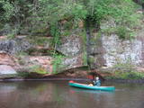 |
The Brasla River flows through a lovely valley that is approximately 300 m wide and up to 30 m deep. It is near the Inčukalns-Valka highway. The river has among the most beautiful rapids in the country, with mighty cliffs (the Brasla cliffs) that can be seen at nearly every curve in the river (except along the lowest reaches of the river). During the winter, various unusual frozen waterfalls can be seen in some of the cliffs, including the Krauļukalns cliff and the Jāņavārti cliff. On the left bank of the Brasla, opposite the Brasla fish farm, there are the Aņīte cliffs -- a series of sandstone cliffs that are 1 km long. The cliffs are between 2 and 35 m in height, and the sandstone cliffs are separated by ravines. On the right bank of the Brasla, there are major cliffs such as the Vāršavu cliff, the Kraukļukalns cliff, the Jāņavārti cliff, the Slūnu cliff, the Virtaka cliff and the Buļi cliff. How can you best learn about them? Boat down the river from the aforementioned highway or even from Straupe, which is further upstream. An alternative is hiking down the right bank of the river, though please take into account that the terrain is fairly extreme, and you are going to have to think about what to do when you arrive at the place where the Brasla River flows into the Gauja. |
|
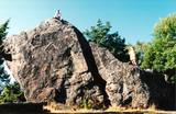 |
Einer der größten Feldsteine im Baltikum (bis 8 m). |
|


