
| Нo | Название | Описание |
|---|---|---|
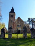 |
Теперешнюю, третью по счету церковь, построили в 1906 году по инициативе и выделенному финансированию Готтхарда фон Будберга. Храм строился в честь его умершей жены Гертруды Ворс. В церкви установлен орган фирмы Walker, который в 1906 г. был построен в Людвигсбурге (Южная Германия). В 1992 году здесь открыта мемориальная доска памяти репрессированных жителей Гарсене. В 100 м к востоку от церкви, на кладбище стоит окутанный легендами фамильный склеп баронов Будбергов.Здесь же находится родовое кладбище баронов.Церковь можно осмотреть изнутри. |
|
 |
Скульптор по дереву создает из дерева саржи политиков, работников культуры и популярных людей, которые можно приобрести. Можно заказать декоративные предметы из дерева, сделанные под открытым небом. Художник делает и распятие. Художница в технике масляной живописи пишет натюрморты, мастерски используя свет и игру теней. Продажа работ. |
|
 |
Корчма «Мазайс Ансис» находится на обочине шоссе Мурьяни – Валка (A3). Срубное двухэтажное здание с террасой. Предлагают баню, имеется место для костра, детская игровая площадка. Сотрудничают с местными крестьянами и надомниками. Латышская кухня: Валмиерский салат, вареный язык, серый горох, завтрак в крестьянском вкусе, холодный суп, филе судака, жаркое из баранины, приготовленная на гриле свинина, слойка из черного хлеба, клубничный крем с варением, ржаной хлеб, травяные чаи. Особое блюдо: Говяжье филе с картофельными блинами. |
|
 |
Здание бывшей Морской школы – образование в Морской школе (1894 – 1914
гг.) получили более 1000 студентов. В советское время здесь размещался пункт пог-
ранохраны Советской армии. Сохранилась пограничная вышка. По дороге к морской
школе видны лесистые приморские дюны с небольшими строениями, создающими
интересный прибрежный пейзаж. Дорогу, соединяющую Морскую школу с морем,
когда-то называли Аллеей капитанов или Дорогой капитанов.
|
|
 |
Остронский (Устронский) Римско-католический костёл
Св. Алоиза был построен в 1935 году первым деканом прихода
Б. Валпитром на участке, подаренном приходу Я. Пушмуцовым.
|
|
 |
The nature reserve “Plieņciema kāpa” is founded in 1987 and covers 60.6 hectares of land. Since 2005 it is a Natura2000 site. The nature reserve protects a 150-200m wide and 3.5km long part of a distinct, continuous dune rampart. The dunes shelter Plieņciems village protecting from sea winds. The key natural values here are rare and protected biotopes of national and European significance: “Wooded dunes of the coast 2180” in the area of 61.8 ha, “Fixed dunes with herbaceous vegetation, 2130 (grey dunes)” in the area of 8.27 ha, “Shifting dunes along the shoreline with Ammophila arenaria (white dunes) 2120 in the area of 3.20 ha”, “Black alder swamp forests 9080”, ) in the area of 2,68 ha, as well as rare and protected species of Latvian and European significance including eastern pasqueflower (pulsatilla patens), Rolling Hen-and-chicks(Jovibarba sobolifera), Nothorhina muricata, Wryneck (Jynx torquilla), Woodlark (Lullula arborea). In the nature reserve, there is a “Vabu square” – a deflation in the dune where for centuries local fishermen have been drying nets. In the 18th and 19th centuries ships were built here. Nine ships have been built here in 1882 - 1925. The four-masted gaff-rigged schooner with hoisting engine “Eurasia” was completed in 1925, the largest ship built by the Kurzeme fishermen. It was one of the works of Martin Morgenstern (1866-1945), a famous shipbuilding master. Thanks to dunes, Plieņciems village was a popular holiday resort and has been mentioned in written sources already in 1738. Clergymen and landlords with their families used to stay here. In 1808, a merchant from Riga bought the local pub and replaced it with a massive two-storey building with a large ball-room and dining hall. On July 15, 1810, a sea bathing facility was opened for health treatment. For arrival of the empress Elisabeth Alexeievna, the wife of emperor Alexander I of Russia, who was a grandson of Catherine the Great, the road from Tukums town was repaired, the two highest hills were levelled, a road passage was dug across the Plieņciems dune, and a lime-tree alley was planted to facilitate access to the beach and bathing spot. Later, in 1920ies, the resort circles consisted mainly of the Kurzeme region landlords. There was a dance-floor in the park of Plieņciems village, and a special orchestra played music for resort guests three times a day. |
|
 |
Возвышается на правом берегу реки Берзес, в западной части Добеле. Городище с укрепленным форбургом было обжито уже в 10 – 13 веке, а у его подножия (площадка между улицей Терветес и Лиепайским шоссе) находился древний город. Как это „обычно” и случалось, то и на этом городище предков (земгалов) в период с 1335 – 1347 года Ливонский орден построил каменный замок. Замок был разрушен в 18 веке, а сохранившиеся от него весьма впечатляющие и живописные развалины сейчас законсервированы. В руинах выстроена смотровая площадка. |
|
 |
Madonas centrālais laukums, kas vēl 20. gs. sākumā bija tirgus laukums. Pēc apjomīgās restaurācijas tas ir kļuvis par ievērības cienīgu pilsētvides objektu. Laukuma ziemeļu pusē atrodas pilsētas un novada pašvaldība un Madonas novada TIC. |
|
 |
This hill in the Tīreļpurvs swamp is an historical object of national importance – the only area in Latvia that is restricted for cultural and historical purposes. There is unique evidence here of World War I fortifications and the so-called Christmas Battle that was fought here.
|
|
 |
Dundagas pili ieskauj parks, kura pirmsākumi ir meklējami jau 17. gs. Tam cauri tek Pāces upīte, kuras uzdambējums veido Dundagas dīķi. Tajā atrodas senatnē (vēl pirms pils būvniecības) mākslīgi veidota sala - Kalnadārza pilskalns. Tam iepretim (dīķa austrumu krastā) atrodas Dundagas pilskalns. Parkā joprojām zaļo (daži lielākie zari ir nolūzuši) t.s. “Rubļa ozols”, kura attēls bija uz 1919. g. izdotās Latvijas simts rubļu naudaszīmes. Parkā uzcelta estrāde. |
|
|
|
Meklējams Zirgu salas dienviddaļā – uz t.s. Golodova dambja. Tornis pieejams kājāmgājējiem un velobraucējiem. Automašīna jāatstāj pie Ezermalas ielas. No torņa redzams plašs skats uz daļēji aizaugušo Liepājas ezera ziemeļdaļu. Laba putnu vērošanas vieta. Ietilpst Liepājas ezera dabas lieguma teritorijā. |
|
 |
Der älteste und größte Kurort Litauens (seit 1794). Mikroklima (Luft der Umgebungswälder), salzhaltigee Quellen, Heilschlamm. Die Altstadt ist ein städtebauliches Denkmal. |
|
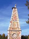 |
Monument „Carrier of the Cross”. Statue of Christ carrying His Cross is placed on a high pedestal of
the pyramid shape. The pedestal was built in 1828 by dean and writer Jāzeps Kirkillo from Rezekne. In 1918,
the monument was renovated. The new statue was placed in 1918. The monument was rebuilt once again
in 1990.
|
|
 |
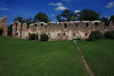
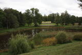
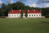
The mansion of the Gārsene Estate is built in the Neo-Gothic style, and its design was based on a villa in Germany. The building was erected between 1856 and 1860, and from then until 1920, the baronial dynasty of the Budbergs and Beningshausens owned it. The castle was expanded with another wing in 1885. Between 1939 and 1940, the building was rebuilt to become a school, and President Kārlis Ulmanis attended its opening on June 2, 1940, when he was taking his last official trip as the country’s president. There are other buildings and a park on the estate. The mansion today is home to the Gārsene Elementary School, but there is also an exhibition featuring the baronial dynasty, the history of the school, and the town itself. Just wait until you see the pot-bellied stoves! Outside the mansion are the Gārsene nature trails – the cultural and historical trail, the baronial strolling trail, etc. Before setting off, buy a ticket at the mansion. In front of the mansion is a memorial stone to Professor Pēteris Kulitāns (1878-1951), who was an agro-chemist. |
|
 |
Im Garten von Vilius Orvidas (1952 – 1992) ist eine Ausstellung der in der Sowjetzeit von der Melioration „geretteten” Steine, Grabkreuze, Holzgegenstände u.a. unter freiem Himmel eingerichtet. |
|
 |
Atrodas Grāfu Plāteru parkā, blakus Krāslavas jaunajai pilij. Tas izvietojies vienā no 18. gs. celtajām muižas saimniecības ēkām. Muzeja ekspozīcija ir veidota interesantā veidā – 17 m garā laivā, kas (laiva ar pieciem airiem) ir pilsētas ģerbonis. Muzeja krājums iepazīstina ar Krāslavas novada vēsturi, sākot no akmens laikmeta līdz mūsdienām. Muzejā tiek organizētas Krāslavas mākslinieku izstādes. |
|
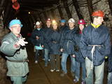 |
Gas mixture is the main raw material for Estonia’s energy and chemical industries, and it is extracted in our day from open quarries or underground shafts. This layer was established during the Ordovician Period between 450 and 480 million years ago, and it is made up of the remnants of plants and animals from that age. In the Kohtla-Nõmme suburb, there is a shaft which can be toured in the company of a guide who will tell you that this is the only layer of its kind in the Baltic States. He will tell you about how the gas mixture has been extracted over the course of history.
|
|
 |
This park was established to protect Lithuania’s longest lake, Lake Asveja (> 20 km). The lake is in a sub-glacial valley carved out by ice during the Ice Age, and it actually resembles a wide and curvy river.
|
|
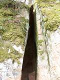 |
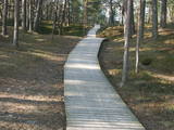
The Vējupīte ravine is meant for those who are not afraid of long and steep wooden stairs of the type that lead you up and down the ravine. From the Līvkalns guesthouse, you can climb the stairs downward, where you will find a shallow (3.6 m) but high (6.1 m) cave – the Pēters Cave. It is something of a gap or a niche. Another 10 minutes or so downstream (toward the Gauja) will lead you to the deep Pūces ravine and its Kraukļupīte River. The Satezele castle hill is at the confluence of the two rivers (90 x 75 m). A wooden castle was there during the feudal era in the early 13th century. Its main entrance was on the western side of the castle hill. You can get to the hill from the depths of the ravine via a wooden staircase. The Kraukļi ravine, in turn, is accessible if you climb down the same stairs and continue on your way toward the Gauja. The ravine is found on the left bank of the Vējupīte, and its sandstone walls are up to 11 m high. The Kraukļi cave, which is 5.2 m deep, is on the wall. Another 10-15 minutes (crossing the Vējupīte on a wooden bridge), and you will find another staircase leading you to Paradīze Hill (see the description above). |
|
 |
Zemnieku saimniecības "Imantas" galvenais darbības virziens ir olu ražošana. Te iespējams apskatīt lauku saimniecībā dzīvojošos dzīvniekus un dažādu šķirņu vistas, uzzinot kaut ko jaunu vai sen piemirstu par vistām un olām. Piedāvā arī iegādāties lauku olas. |
|


