
Outcrops
Different shapes and types of outcrops Latvian territory
| Overview | Details |
|---|---|
 |
Latvia
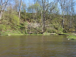
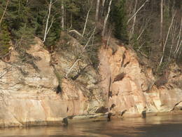
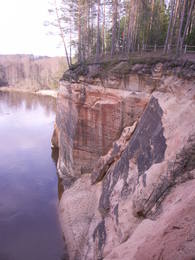
Kazu iezisAinavisks, ap 340 m garš un līdz 15 m augsts atsegums, kas atrodas nepilnu kilometru lejpus Raunas ietekas Gaujā, kreisajā pamatkrastā. To veido sarkandzeltenīgi Gaujas svītas smilšakmeņi. Gar Kazu ieža austrumu daļas pakāji izkaisīiti vairāki lieli laukakmeņi, kas ērti iekārtojušies uz smilšakmeņos izskalotas pamatnes.  101 101
Services
101km - Distance from countries capital city |
 |
Latvia
Pavaru atsegumiSmall sandstone outcrops on the shores of the Ciecere River. Fish fossils have been found here.
|
 |
Latvia
Ogres dolomitu kraujaThis is a unique geological object of paleontological importance. Up to four metres high, the cliff has yielded up fossils of ancient invertebrates and fish.
|
 |
Latvia
Zanas lejteceThis territory protects a lime outcrop found on the shores of the lower reaches of the Zaņa River. There is a path for active hikers which begins at the Zaņa mill (1864, rebuilt 1890, shut down 1960). The path weaves its way along the steep shores of the little river, heading toward its mouth.
|
 |
Latvia
Tujas atsegumsAinavisks jūras viļņu izskalots smilšakmens atsegums
dienvidos no Zaķupes ietekas.
77
Services
77km - Distance from countries capital city |
|
|
Latvia
Katrinas iezisAp 200m garš un līdz 15m augsts ainavisks atsegums upes labā krasta asā līkumā. Tam iepretim otrā krastā (500m) Līgatnes dabas takas.
75
Services
75km - Distance from countries capital city |
 |
Latvia
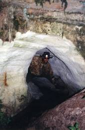
The Velnala cliffs and their surroundingsBoaters along the Gauja will see the Velnala cliffs, which are the last mighty wall along the banks of the Gauja River valley – approximately 15 m high. From the opposite shore of the river, where there are leisure facilities, once can spot the Krimulda Devil’s cave, which is in the centre of the cliff, is some 19 m deep, and is 4.7 m high. There were once wooden structures which allowed people to visit the cave, but that stopped in 1980 for safety reasons. If you head toward Turaida along the lower part of the basic Gauja River shoreline from the Velnala cliffs, then, particularly when the trees are bare, you will see the mighty sandstone Piķene cliff. At its foot is the Piķene beaver trail, which is approximately 1 km long. On quiet evenings, you may well spot a beaver at work. Along the path you will see the Small Devil’s cave (5 m deep) with the Wisdom Stream that flows out of it. The Aunapiere cave is almost as deep. Between the cliff and the Gauja are several small rivulets which are of enormous importance in preserving the diversity of the surrounding environment. 54
Services
54km - Distance from countries capital city |
 |
Latvia
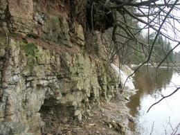
The Sietiniezis cliffThe Sietiņiezis cliff is on the right bank of the Gauja River between Valmiera and Jāņmuiža (follow signs along the road). There is a circular nature trail here. Sietiņiezis is one of the largest white sandstone cliffs in Latvia, up to 15 m high and around 500 metres long. There is an interesting diversity in form here, with small caves and niches, erosion-based ravines, as well as sandstone formations which are reminiscent of poles. The word "sietiņš" refers to "sieve," and the cliff is so called because bees have drilled holes into it for time eternal. From the southern part of Sietiņiezis, you can get a good look at the ancient Gauja River valley, and all around it are lovely pine forests. There is a place on the banks of the Gauja which is meant for campfires and meals. 113
Services
113km - Distance from countries capital city |
|
|
Latvia
Liepas iezisAp 400m garš un līdz 16m augusts atsegums upes kreisajā krastā.
53
Services
53km - Distance from countries capital city |
 |
Latvia
Stiglavas atsegumiVairāki dažus metrus augsti smilšakmens atsegumi, kas izveidojušies Stiglavas (Stiglovas) strauta gravas nogāzēs. Kaut arī teritorija tiek popularizēta kā tūrisma objekts, tajā nav īpašu šim nolūkam paredzētu labiekārtojumu. Teritorijas apmeklētāji bojā smilšakmens atsegumus, kas ir aizsargājami biotopi!
|
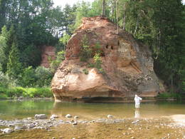 |
Latvia
The Zvarte cliffThis is one of the most beautiful and popular tourism locations in Vidzeme. The cliff is 45 metres high, and the height of the lovely open-faced portion is around 20 metres high. You can look at the wide and deep Amata River valley and its forested banks.
83
 1-12 1-12
Services
83km - Distance from countries capital city
1-12 Active season months |
 |
Latvia
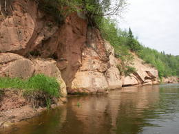
The Ergeles (Ergli) cliffsThese sandstone cliffs were once known as the Pieškalni or Pieškaļi cliffs. They are around 7 km to the North from the centre of Cēsis. These are the most monolithic sandstone cliffs in the Baltic States – around 700 m long (with some 330 m along the Gauja River) and a maximum height of 22 m. There is a viewing area which offers a grand view of the Gauja River valley. Water tourists will boat up to the majestic wall of the cliff and will be surprised at what they see! The name of the cliffs, Ērģeles, is the word for "pipe organ" in Latvian, and the name was supposedly given to the cliffs because of the echoes which can be heard there – they reputedly sound like an organ. Hikers and boaters must be very careful when in this area – please make sure that you are safe! Please note, too, that the infrastructure of the cliff is scheduled to be renovated in 2012. 94
Services
94km - Distance from countries capital city |
 |
Latvia
Felsen KukuEine der malerischen Sandsteinaufschüssen in Lettland. Die Länge beträgt ung. 500 m, die Höhe – 43 m. Gegenüber befindet sich die Ķūķu-Schnelle. 89
Services
89km - Distance from countries capital city |
|
|
Latvia
Zivtinu atsegumiIespaidīga smilšakmens atsegumu virkne, kas
izveidojās pēc 2005. g. orkāna.
87
Services
87km - Distance from countries capital city |
|
|
Latvia
Springu FelsenEinen malerische Sandsteinfelsen bis 600 m lang und 21 m hoch am linken Flussufer vom Gauja. 70
Services
70km - Distance from countries capital city |
|
|
Latvia
Edernieku klintisLīdz 40m augsta ar mežu apaugusi Gaujas labā pamatkrasta nogāze ar vairākiem smilšakmens atsegumiem. Viens no tiem atrodas nogāzes lejasdaļā un veido 7m platu 5m dziļu nišu. Otrā krastā – vairākus metrus augstais Leimaņu iezis. Abi atsegumi atrodas aiz Amatas ietekas.
|


