
| Nr | Name | Beschreibung |
|---|---|---|
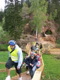 |
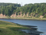
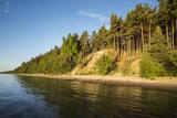
In the centre of Līgatne, on the right bank on the rapid Līgatne River, there is a viewing plan which offers a close-up look at one of the most impressive sandstone cliffs which rise above it – the Lustūzis cliff. There are artificial caves in the wall of the cliff, which locals use as cellars and as places to store their property.
|
|
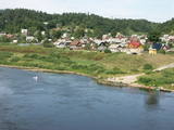 |
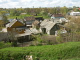
An all-encompassing view of the urban environment next to the Daugava River valley is offered at the car park which is at the start of Augusta Street on the boundary of Krāslava. The unique wooden buildings of the area (the Kaplava Street region) can also be seen on the bridge which crosses the Daugava. Climb Karņickis Hill and hike through the park of the Plāters family of nobles. From there, you will see more local scenes.
|
|
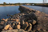 |
Molu (sākotnēji – pāļu rindas ar akmeņu krāvumiem) izbūve pie Sakas ietekas jūrā tika uzsākta 1878. gadā, lai nodrošinātu ostas darbību. 1929. gadā notiek molu pārbūve, pagarinot tos ar masīviem betona blokiem. Pēdējā rekonstrukcija notika 2010. gadā, pārveidojot molus par ērtu pastaigu un makšķerēšanas vietu, no kuras var vērot arī saulrietu. |
|
 |
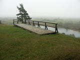
Aptuveni 0,5 km dienvidos no Mežotnes pilskalna atrodas Vīna kalns, kas līdzīgi kā Mežotnes pilskalns, ir veidots, izmantojot Lielupes ielejas stāvās krastu nogāzes, tās pārveidojot. Vietvārds ir it kā radies no stāsta, ka šeit parādījies dievgalds ar maizi un vīnu. Vīna kalnu ar Mežotnes pilskalnu savieno jauka koka laipa, kas ved pa Lielupes ielejas pamatkrasta lejas daļu. |
|
 |
In Aizkraukle, drive down Enerģētiķu Street to the Selonian side (there will be small “pockets” at the side of the road) to see one of the best views of the Daugava River valley, reminding us of what this fateful river was like before the power plant was built. You will see that the river has eroded the steep cliffs on the right bank. The further part of the valley is part of the Daugava Nature Park.
|
|
 |
From the highest point in the Alūksne highlands, you will see an unusually beautiful view of the surrounding forested hillocks and the small areas of meadows and farmland. Sadly, there are no improvements to the location, which can be difficult to access. It is on private property.
|
|
 |
Dieser Weinberg war schon in den Zeiten des Herzogtums Kurland als der Ort bekannt, wo so weit im Norden Weintrauben gezüchtet wurden. Hier werden sie immer noch gezüchtet, und aus den Weintrauben wird der säuerliche nordkurländische Wein hergestellt. Jährlich findet in Sabile in der zweiten Hälfte von Juli das Weinfest statt. |
|
 |
The viewing area is near the top of the Vilce castle hill, with a view of the Rukūze River valley, Zaķi meadow, and surrounding forests. This is an unusual landscape for the region of Zemgale. The Vilce baronial estate is nearby.
|
|
 |
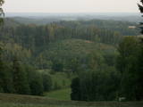
The area known as the territory of high hillocks has several heights – Lakta Hill (250 metres above sea level), Egļu Hill (268 metres above sea level), and Bākūži Hill (272 metres above sea level). They are connected by an earthen road – it’s worth hiking the trail to find the best viewing areas. A very fine view of the backs of hillocks in the Vidzeme highlands can be seen from the northern side of Lakta Hill.
|
|
 |
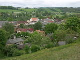
In Dagda, on the side of Daugavpils Street, there is a forested hillock that is the Lubāne castle hill. On the upper part of its southern side, there’s a viewing area which offers a view of the small Lake Lubenenis, the eastern part of Dagda, and the white tower of the local Catholic church. Legend has it that treasure is buried here.
|
|
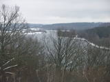 |
At the Aizkraukle Lutheran church along the upper part of the shores of the ancient Daugava River valley, there is a bit of an old road from which one of the most beautiful views of the central section of the river can be seen, particularly when the trees are bare. Approximately one kilometre to the North-west is the Aizkraukle castle hill, which offers a no less impressive view.
|
|
 |
The Buse (Matkule) castle hill is near the Imula River. From the castle hill and from the opposite shore of the river, you can find one of the loveliest views of Kurzeme’s small rivers. Their appearance is best when trees and other flora are bare and the view is unimpeded. A wonderful view of the Imula valley is also seen on the road to the castle hill – near the Buse homestead.
|
|
 |
One of the highest dunes in Latvia, located between Bernāti and Jūrmalciems villages. It is 37m high and offers a magnificent view of the sea and natural pine forests. The highest dunes in Latvia stand to the South of Jūrmalciems village: the Pūsēnu hill, the Ķupu hill, the Mietragkalns or Tiesas hill, the Pāļu hill, the Garais hill, the Ātrais hill, the Lāvas hill. The Pūsēnu dune is the highest of these dunes which are all called hills by the local people. The Pūsēnu hill developed between 1785 to 1835 when shifting sand became extremely dangerous. Several homesteads were buried in sand, among them „Pūsēni”, where a forester’s family lived. The family is said to have moved to Bārta. The dune was named after the buried homestead. Jēkabs Janševskis, a Latvian writer, wrote in his book „Nīca”: “In olden times, large pine trees were growing in the dunes on the coast of Nīca and they stood steady and firm. But i Swedish times (around 1650), the Swedes built a large kiln for charcoal and tar. Pine wood and stumps provided an excellent material for this. Once a big fire rose, and the charcoal kiln burned down as well as the whole pine forest. The remaining stumps and bare trunks in the vast burnout could not hold the storm-driven sand; it flew further and further burying not only the burned-out forest, but also the nearest fields. In wintertime, when the vast, low marshy grasslands were covered with ice, jets of sand drifted further over its surface, and soon most of the grasslands and large meadows turned into sandy heath-land and dunes.” To reconstruct Liepāja, severely damaged during WWII, a silicate brick factory was built in the town. The main raw material was white sand and it was taken from the Bernātu forest. In the 1960-ies they started to dig off the Green Dune and the White Dune, later also the Pūsēnu hill. The excavators used to work day and night, in three shifts. The work stopped at around 1980, as there was no more sand suitable for production of brick. A trail is set up to facilitate walking in the Pūsēnu Dune in the Bernātu Nature Park. |
|
 |
The Ludza castle hill offers one of the most interesting views in Latgale – that of the oldest town in Latvia and its historical centre, Great Lake Ludza and Small Lake Ludza, the ruins of the castle of the Livonian Order, Baznīckalns hill, churches, the regional research museum, the craftsmen’s centre, etc.
|
|
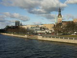 |
The classical skyline of Old Rīga can be enjoyed from several locations – Mūkusalas Street, between the railroad bridge and the stone bridge, from the stone bridge, from the A-B dam, from the grounds of the central office of the Swedbank bank, from the Vanšu bridge, and from the Ballast Dam at Ķīpsala. You can hike or bike from location to location. During the summer, little ships cruise up and down the Daugava to offer different views.
|
|
 |
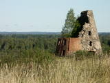
This is one of the most lovely and expressive castle hills in Latvia, with a very fine view of territory all the way to Lithuania. According to Ernests Brastiņš, a researcher of castle hills in Latvia, this was the site of the Semigalian Sidrabene castle. There are no improvements in the area.
|
|
 |
Die Steilküste von Ēvaži – bis zu der 8-15 Meter hohen Steilküste führt der 0,3
km lange Pfad, an dessen Ende man einen der schönsten kurländischen Anblicke
auf die Bucht von Riga hat.
|
|
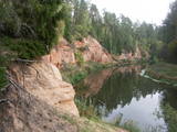 |
The Neļķes cliffs are in Skaņākalns Park, and they offer the most beautiful view of the Salaka River valley, with its sandstone cliffs and peaceful river. There are good views from the “devil’s pulpit.” It’s worth visiting the Skaņamkalns Hill to check out the views from the famous echo cliff. This is part of the ZBR.
|
|
 |
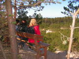
On the left bank of the Gauja River, opposite the Piķene cliff is the mighty Beite cliff which is split by a deep ravine. On the left side there is Ķeizarskats (Emperor's View), which is approximately 67 metres above the level of the Gauja and offers a fine view of Krimulda and the Turaida Castle. The viewing place was installed in 1862, when Russian Tsar Alexander II visited Sigulda. On the right side of the ravine is the mighty wooden Ķeizarkrēsls (Emperor's Chair). To get there, you have to cross the ravine (there are wooden stairs and a forest trail). You can go around it on Laurenču, Kalna and Gulbju streets. |
|
|
|
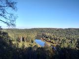
No ūdens tūrisma attīstības centra „Bāka” skatu laukuma, kas atrodas Lubāna ezera ziemeļdaļā pie V 560 autoceļa, paveras viens no labākajiem Lubānas ezera skatiem. Redzams milzīgais Latvijas lielākā ezera klajs un Kvāpānu – Īdeņas zivju dīķu ar dambjiem ainava. |
|
