
| Nr | Name | Beschreibung |
|---|---|---|
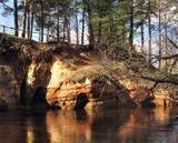 |
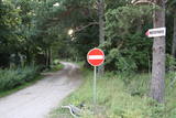
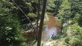
Taka ved gar Vaidavas krastu, kur iespējams veldzēties dabas skaistumā, kāds vērojams tikai šeit. Starp Apes vidusskolu un kapsētu Vaidavas upes kreisajā krastā ir izveidojušies 8 - 10 m augsti, līdz pat 100 m gari smilšakmens atsegumi - Raganu klintis. To lejasdaļā upes straume izskalojusi nelielas nišas. Pie klintīm pāri upei izveidots gajēju tiltiņš uz otru krastu, no kura klintis paveras visā savā krāšņumā. Te ir teikām un nostāstiem apvīti avoti un alas. Avots ar skaidru ūdeni iztek no vietas, kur Vaidavas upes smilšu klints krasts ir augsts un stāvs. Senāk vietējie ticējuši, ka tas ir veselības avots, jo daudzi to lietojuši dažādām acu slimībām.Dīvainos dabas objektus – Vilkaču priedi un Dvīņu priedes, Raganu slotu, “raganu apļus”, “raganu kaulus” u.c. te var apskatīt un vides gida vadībā mēģināt izprast to veidošanos
|
|
 |
Zirgi un citi lauku iemītnieki. Dažāda veida izklaides ar zirgiem gan saimniecībā, gan ārpus tās, un saimniecībā mitošo iemītnieku apskate. |
|
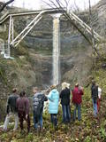 |
This is a cliff with various levels. Known as the North Estonian cliff, it stretches all along the shore of the Bay of Rīga in Estonia, including some of the local islands. The most expressive part in geological and landscape terms is the Saka-Ontika-Toila cliff, which is around 22 km long and offers an unusual natural environment. The cliff is as much as 53 m high, and it has a fairly virginal forest along its slopes. The layers of clay, sandstone, limestone, etc., come from the Cambrian and Ordovician periods. The Valaste juga (Valaste waterfall) is 24 metres high. After a longer period of freezing temperatures, the waterfall has a particularly impressive appearance. Seasonal waterfalls (8-10 m) can be found near the villages of Ontika and Toila.
|
|
 |
Lake Rāzna (57,8 m2) is often called the sea of Latgale. It is the biggest lake in Latvia. Rāzna is situated
on the hill Rāznava. You should see beautiful landscapes, high peaks and Latgalian castle hills. Enjoy the
recreation places beside the lake, the National park of Rāzna and its surroundings. The place is included in
the European Union network of protected areas NATURA 2000. The lake has 10 islands and two gulfs. The
level of the water reaches 163.8m.
|
|
 |
These are beautiful and impressive views, particularly early in the morning, of the historical locations of Alūksne. Go to Templis Hill, the Aleksandrs Pavilion, the obelisk which commemorates Heinrich von Fittinghoff, and the memorial to soldiers of the No. 7 Sigulda Brigade for good views. The Templis Hill, the castle ruins, the estate and the pavilions are arhitectural monuments.
|
|
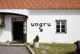 |
Ungru is a seaside hotel in the north of Hiiumaa. There is a high-class restaurant on the ground floor. The second floor has 4 rooms with all amenities. Dauble Deluxe beds with sea views. |
|
 |
Iespēja iepazīties ar savvaļā augošiem un kultivētiem ārstniecības augiem, pašiem tos ievākt, izbaudot Latgales neskarto dabu, sasiet ārstniecības augu slotiņu veselībai un pirtij. Nodegustēt augu tējas lauku klusumā vai tieši otrādi - kopā ar „Muzikantu ciema” muzikantiem, piedaloties jautrās aktivitātēs, iepazīties ar bagāto latgaliešu tautas dziesmu un polku pūru. |
|
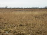 |
Der größte Teil dieses geschützten Territoriums besteht aus einem flachen und eutrophischen Wassergebiet, in dem viele Vogelarten nisten, darunter einige seltene und geschützte. Spezialisten meinen, dass hier zwischen 150 und 450 Paare der Lachmöwe regelmäßig nisten.
|
|
 |
Auf dem Bauernmarkt Pärnu kann man verschiedene Waren von Kleinproduzenten aus Pärnumaa und anderen Regionen, darunter vor Ort gebackenes Brot und Süßwaren kaufen. |
|
 |
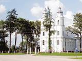
Eine aus Holz von den einheimischen Handwerkern nach der Finanzierung der Grafen Plater gebaute Kirche stammte von 1655 bis 1658 als eine nicht große einschiffige Basilika. Das einzigartige kulturhistorische Denkmal gilt als eine der ältesten Holzkirchen in Lettgallen. Die Schnitzerei des Zentralaltars in den Formen des Barocks wurde von den Meistern der Schnitzereischule von Stelmuže erschaffen. Im Seitenaltar befindet sich das Bild aus dem 18. Jahrhundert “St. Maria Magdalena”. Die Kirche wurde 1698 auf den jetzigen Platz – am rechten Daugava-Ufer befördert. Das Gebäude wurde mehrmals – 1890 und 1918 erneuert. Um die Kirche herum befindet sich einen Steinzaun aus dem Ende des 17. Jahrhunderts mit einem separat stehenden Glockenturm aus der Mitte des 19. Jahrhunderts, der 2002 restauriert wurde. Gemäß verschiedenen Informationsquellen kann man behaupten, dass die Gemeinde von Indrica die älteste in Lettgallen ist. |
|
 |
Atrodas Grāfu Plāteru parkā, blakus Krāslavas jaunajai pilij. Tas izvietojies vienā no 18. gs. celtajām muižas saimniecības ēkām. Muzeja ekspozīcija ir veidota interesantā veidā – 17 m garā laivā, kas (laiva ar pieciem airiem) ir pilsētas ģerbonis. Muzeja krājums iepazīstina ar Krāslavas novada vēsturi, sākot no akmens laikmeta līdz mūsdienām. Muzejā tiek organizētas Krāslavas mākslinieku izstādes. |
|
 4 Tagen
|
Маршрут проходит по живописным природным местам Эстонии – биосферному заповеднику Моонзунда (Moonzund), национальному парку Матсалу (Matsalu) и заповеднику Вийдумяэ (Viidumäe). Маршрут включает два самых больших острова Эстонии, богатых природными и культурными памятниками – Сааремаа и Хийюмаа, - а также малые острова Муху и Касари. В маршрут включены самые интересные природные тропы (длина каждой 1-5 км), смотровые вышки и места наблюдения за птицами, биотопы, а также три поездки на пароме между островами Моонзундского архипелага. |
|
 |
Heutzutage ist die ehemalige sowjetische Abteilung der Flugabwehr in Jūrkalne ein Privateigentum und da befindet sich eine Mototrasse.
|
|
 |
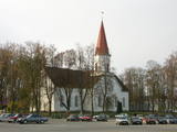
St. Anna Roman Catholic Church of Bērzgale. The Church was
built in 1770 and sanctified in 1776. The building is an example of Baroque style with a woodcarved altar
and two pictures of Virgin Mary. The church resembles Aglona Basilica.
|
|
 |
Bis zum 13. Jh. gehörte der Kreis von Smiltene zu dem von den Letgallen bewohnten Land Tālava. Nach der Invasion der Kreuzritter hat den Kreis der Erzbischof von Riga bekommen und am steilen Ufer des Flusses Abuls hat er im Jahr 1370 eine Burg gebaut. Die nachfolgenden Kriege und Seuchen haben weder die Bebauung der Ortschaft, noch die Einwohner geschützt. Die heutigen Konturen der Stadt begannen sich am Ende des 19. Jhs. mit den aktiven Tätigkeiten des Barons von Lieven – des Landgutinhabers von Smiltene – zu bilden. Bis zum Ersten Weltkrieg arbeitete in Smiltene eine Holzverarbeitungsfabrik, ein Wasserkraftwerk (1901, das erste in den Baltischen Ländern) und andere Unternehmen. Als sich im Jahr 1944 die deutschen Streitkräfte zurückgezogen haben, wurde in einem Brand der größte Teil der historischen Bebauung der Stadt zerstört. |
|
 |
In the central part of the Žemaitija Highland, this park was established to protect local landscapes. Lithuania’s highest hillocks are found here – Mėdvegalis (235 m above sea level) and Šatrija (229 m). There are also other hillocks which offer a great view of the area – make up your own tour here.
|
|
 |
Nature trail "Curves of Riva" starts at Ulmale-Labraga Lutheran Church and continues 3 kilometres down the picturesque downstream of river Riva. Rīva here flows in a canyon-type ravine which reaches 12 meter rise at some points. The trail reveals countless river twists and turns and steep coastal cliffs. The trail is partly accessible with an assistant and is marked with green paint. |
|
 |
In Ošvalki – in einer Ortschaft zwischen Jūrkalne un Sārnate ist ein Gedenkzeichen “Hoffnungssegel” errichtet worden. Das Gedenkzeichen ist den lettischen Flüchtlingen (1944 – 1945) gewidmet, die über die Ostsee in Fischerbooten nach Schweden geflüchtet sind. Das Zeichen ist in den Dünen zwischen Weg und Meer aufgestellt worden. |
|
 |
Found along
|
|
 |
Die Wälder von Zvārde befinden sich auf einem ehemaligen sowjetischen Luftstützpunkt. Das Gebiet war nicht bewohnt und für Zivilisten nicht zugänglich. Auf dem riesigen Gelände gibt es verschiede Waldarten – Nadelwald, Schwarzerlensümpfe usw. Die Tatsache, daß das Militär dieses Gebiet kontrolliert hat, ist der Grund dafür, daß in den Wäldern von Zvārde viele seltene und geschützte Vögel leben, brüten und Futter finden. Einige Teile des alten Luftstützpunktes sind noch vorhanden, wie z.B. eine Überwachungsstation. Es wird empfohlen, daß sich Besucher nur auf den allgemein benutzten Straße bewegen.
|
|


