
| Nr | Name | Beschreibung |
|---|---|---|
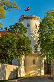 |
Cēsis is in the centre of the Gauja National Park, but it is not part of the park as such. There are many interesting places in Cēsis to visit and examine. The oldest part of the town is of key interest. The origins of Cēsis can be found at Riekstu hill, which is 18 metres high. Between the 11th and 13th century, there was a wooden castle here built by the Vendians. The hill is in the central part of the castle park, and it offers a good view of the park, pond and the ruins of the Cēsis castle, which can be accessed via a long cascade of stairs. The Cēsis castle (see below) was built in the early 13th century as a residence for masters of the Livonian Order, and it was one of the strongest fortresses in the Baltic territories. Alongside it is the New Cēsis castle, which was built in 1777 where the gate fortifications once stood. The Cēsis Museum of History and Art is in the building, alongside which is a visitors centre and the Cēsis Tourism Information Centre. From the tower of the castle, there is a fine view of the castle ruins, St John's Lutheran church and the northern part of the town. Opposite the New Cēsis castle are stables and a wheelhouse (both from the first half of the 19th century). The Cēsis Exhibition Hall is there today. You can look at the exteriors of the granary, the hut for coachmen, and the old brewery. On the other side of the street is the romantic Maija park, which was installed in the 1830s. The park is popular among parents with children, because there is a playground there. From this area, you can walk down some of the old streets of the town – Lielās Katrīnas, Mazās Katrīnas, Mazā Kalēju, Kalēju and Lielā Līvu streets, plus Līvu Square. The wooden buildings along the streets date back to the late 18th and early 19th century. Torņa Street, which weaves its way along the defensive walls of the Medieval castle, offers a look outside the church of a sculpture by Matiass Jansons, "As the Centuries Pass". Legend says that if you rub the lantern carred by the Old Man of Time, you can see the future. One of the most impressive buildings in Cēsis is St John's Lutheran Church, which was built in the late 13th century for the Livonian Order. It is a basilica built in the Roman style and with Gothic elements. The tower, which is 65 m high, was built in 1853. The building was reconstructed several times during the 20th century. Inside the building are grave epitaphs for masters of the Livonian Order and for bishops. The pulpit was installed in 1748, the oak altar followed in 1858, and the altar painting "The Crucified One" dates back to 1862. The stained glass windows around the altar are of great artistic value. The organ was built in 1907 by the E.F. Walker Company, and the instrument is one of the best concert organs in Latvia. A sun clock featuring the year 1744 is at the south-western corner of the church. It is worth climbing the church's tower. At the foot of the building is Rose Square, which began as a market square in the mid-19th century, remained in place until 1927, and was restored in 2008. This is the central square in the town today. During the Medieval Era, there were stockades here, along with the city's well. Rīgas Street has been the main street of the old town from the very beginning, and it is here that you will find the most architecturally outstanding buildings in town from the 18th and 19th centuries. They include the former Cēsis City Hall, the Fābers building, and the Princess building. At one end of the street is Līvu Square, where, during the 13th century, there was a church, a cemetery and a gate in the town walls. Today the square features a lighted fountain which is on the site of a 13th century well known as Lejas Šķimbēgs. At the other end of the street is a reconstruction of the foundations and surface elements of the Rauna gate that was a part of the town walls in the 14th and 15th centuries. The site offers a good idea about Medieval fortifications and the size and mightiness of gates therein. |
|
 |
Die Kalkschlucht, die enstand, als sich der Baltische Eissee zurückzog wird von einem mächtigen Strom durchzogen – dem Mežmuiža. Sein Wasser enthält eine hohe Konzentration an Kalkstein. Das Wasser des Flusses fliesst in einen Mühlteich, der eine sehr interessante Farbe hat. Der Bildhauer Teodors Zaļkalns hat hier einst in der Kalksintermühle gelebt, die neben dem Teich steht. Waldpfade wurden für Besucher des Stromes eingerichtet.
|
|
 |
Cafe "Krisdole" is located in the very center of Liepaja, the cafe offers freshly baked delicacies from seasonal, own and local products. Classic and traditional and new and innovative recipes from Kurzeme. |
|
 3 Tagen
|
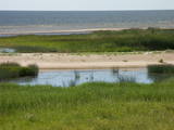
The Liv Coastline involves a series of shoreline villages from Ovīši to Ģipka along the shores of the Baltic Sea and the Bay of Rīga. Like Latvians, Livs are an indigenous population in Latvia, with ancestors who lived here at least 5,000 years ago. They populated extensive parts of Kurzeme and Vidzeme, and the area in which they lived the longest was Northern Kurzeme, on the shores of the Baltic Sea. Today visitors to the Liv Coastline mill meet real Liv fishermen, feel the aroma of smoked fish, enjoy traditional dishes, look at diverse ancient fences, learn about the reticent charm of the local landscape, enjoy the place where two seas, birds and people meet at Cape Kolka, hear the Liv dialect of the Latvian language, see rounded hillocks and swampy areas, visit the Šlītere lighthouse, and see the green-white-blue Liv flag, red bilberries, bird migration routes and blue cows. The oldest evidence of the life of Livs can be found in the Liv centres. The Liv language and culture are still alive in place names, handicrafts, folk costumes, and the world view and lifestyle of people who live in the area. The Liv language and cultural values are part of Latvia's national cultural heritage, and traditional Liv culture is part of the Latvian Canon of Culture. |
|
 |
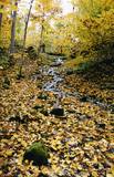
After a big storm in 2005, the nature trail of the Randu meadows was restored. It is about 4 km long, and there is a bird-watching tower which offers a fine view of unique shoreline meadows with small lagoons and areas of reeds. It is a fine place to watch migrating birds. This is part of the Northern Vidzeme Biosphere Reserve (ZBR).
|
|
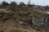 |
In Bolderāja – östlich von der Lielupe Straße und südöstlich von der Jātnieku Straße am Ufer von Daugava sind Überreste von vier in die Luft gesprengten Batterienpositionen erhalten geblieben. Diese Batterien, in denen Geschütze des Kalibers 152 aufgestellt waren, sind einen Teil vom ehemaligen Fortifikationssystem von Riga (siehe auch Komētforts, Festung in Daugavgrīva, Fortifikationen in Mangaļsala). Das Ziel der Batterien war die Stadt von den Angreifer, die von der Meeresseite kämen (kamen) zu schützen. Von dem Oberteil der Batterien ist der Fluss Daugava und neu aufgeschütteter nördlichen Teil des Russischen Insels (ein riesengroßer Sandberg). Der Zustand des historischen Denkmals und der Umgebung des Denkmals ist mehr als schlecht...
|
|
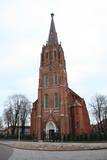 |
Находится в стороне от площади Куршу, ул. Э.Венденбаума, д. 1. Старейшая церковь города, сведения о которой сохранились с 1508 года. Первый храм на этом месте был построен из дерева. После неоднократных перестроек (последняя – в 1893 г. под руководством архитектора Лиепаи Пауля Макса Берчи) храм приобрел теперешний вид в неоготическом стиле с башней высотой около 60 м. Церковный интерьер славится одним из самых выдающихся шедевров времен барокко в Латвии – алтарем (резчик по дереву Николя Сефренс младший), который в 2012 году отметил свое 350-летие.Алтарь считается одной из самых выдающихся работ Восточной Европы того времени. Ретабло алтаря (5,8 x 9,7 м) известно тематическим циклом страданий Иисуса. В храме находится третий по величине орган Латвии, который построен по эскизам композитора и органиста Альфреда Калниньша. Церковь можно осмотреть изнутри и подняться на колокольню. |
|
 |
Der Bau der Burg wurde vom Schwertbrüderorden 1207 angefangen, aber 1236 umgebaut und auf Bedürfnisse des Livländischen Ordens angepasst. Die Burg wurde im Laufe der Kriege in den 16 – 17 Jh. sehr zerstört. Heute ist die Burg restauriert. Von einer Freilichbühne öffnet sich einen schönen Blick aufs Gauja-urstromtal. |
|
 |
Iespēja atpūsties un relaksēties pirtiņā, baudot latviskos pirts rituālus. Sildīšanās un pēršanās ar pirtsslotām, augu skrubji un maskas, kāju vanniņas un zāļu tējas. Pēc pēriena – veldze dīķī. Pirts tā ir svētnīca miesai, garam un dvēselei. Piedāvājumā arī izglītojošā programma par augu spēku un to izmantošanu savai labsajūtai. Apmeklējums noteikti iepriekš jāpiesaka! Vietu skaits ierobežots! |
|
 |
Divus kilometrus garās lokveida takas sākums ir meklējams pie Somā nacionālā parka apmeklētāju centra (atklāts 2000. gadā) – Tēramā ciemā. Tā ved gar Mardu strauta (Mardu oja) krastu, kur krustām šķērsām ir sakrituši bebru nogāztie koki, radot diezgan juceklīgu skatu. Apmeklētāju centrā var iegūt nepieciešamo informāciju, noskatīties videofilmu un nacionālajam parkam veltītu ekspozīciju. |
|
 |
Station der Raketen zum Fliegerabwehr ist im weiten Territorium südlich von Pāvilosta gelegen. Ein verlassenes und degradiertes Naturterritorium, wo die Warnungszeichen "Gefährlich, lebensgefährlich!" aufgestellt sind.
|
|
 |
The museum offers information about local manufacturing traditions, as well as products from SIA Naukšēni – various oils (made of rapeseed and hempseed), ten non-alcoholic beverages (kvass, mineral water), as well as tastings of homemade wine. Some of the products can be purchased. |
|
 |
Atrodas ~ 0,4 km no Latvijas – Lietuvas robežas, Sventājas ielejas labā krasta nogāzē. Atrodama informācija, ka avotu tīrot, atklājusies 5 x 5 m ozolkoka „grīda”. Avots ir labiekārtots – virs tā slejas lapene ar niedru jumtu. Vēl pavisam nesen pie tā auga Latvijas dižākā ieva (nolūza), kuras vietā tagad kuplo biezs atvašu pulks. |
|
|
|
Viens no raksturīgiem karsta parādību piemēriem, kur nelielas upītes - strauta ūdeņi pazūd vairākos ūdensrijējos un pēc kāda brīža - iespaidīgās Lauces ielejas krastos iznāk spēcīgu avotu veidā, tālāk ieplūzdami Lauces upē. Šī parādība dinamikā vislabāk ir novērojama pēc lietavām vai pavasaros sniega kušanas laikā un kādu brīdi pēc tam. |
|
 1 Tag
|
Dieser Abschnitt des Baltischen Küstenwanderweges ist eine verhältnismäßig kurze Wanderung entlang eines bezaubernden Sandstrandes. Von der Festlandseite ist er durch lichterfüllte Kiefernwälder mit eindrucksvollen Dünen und Dünenwallen abgegrenzt. Vom Strand bis Carnikava führt der Pfad durch eine Waldpromenade. Über einen Schutzdamm verläuft der Pfad um den Fluss Vecgauja herum und erreicht die Fußgängerbrücke über die Gauja. Vor Beginn oder zum Abschluss der Wanderung lohnt es sich, die Atmosphäre Kneipen oder Sommercafés am Strand Vecāķi oder in Carnikava gemütlich zu genießen. |
|
 |
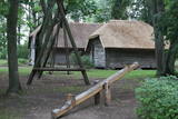
The artist Agris Liepiņš was the initiator of the project to recreate a 12th-century Ancient Latvian wooden castle. The building was erected in 1997 on the basis of samples from the remnants of castles found at various castle hills in Latvia. This is an idealised version of the residence of Uldevens, who was once the senior official of the Lielvārde region.
|
|
 |
Dole ist die größte Insel des Flusses Daugava. Von der nordöstlichen Seite wird die Insel vom Fluss Daugava umgeströmt, von der südwestlichen Seite – vom ruhigen und allmählich bewachsenen Gewässer des Seitengerinnes von Daugava. Die Insel ist ein Naturpark (das besonders geschützte Naturterritorium). Der Naturpark wurde 1987 zum Schutz der nach dem Bau des Rigaer Wasserkraftwerkes erhaltenen Landschaft und kulturhistorischen Werte der Insel von Dole, sowie seltenen und geschützten Pflanzen- und Tierarten gegründet. Noch ein Ziel des Errichtens des Naturparks ist die Förderung der Bildung und Erholung der Gesellschaft. Eins der bekanntesten Objekte der Insel von Dole ist das Daugava- Museum, das im Wohngebäude des Landgutes von Dole eingerichtet wurde. Im Fundus des Museums sind ~ 13 000 verschiedene Objekte – Zeugen der Geschichte der Insel von Dole und der Daugava-Ufer – Kleidung der Balten und Liven, Arbeitsgeräte, Alltagsgegenstände. Die Exposition macht mit der Geschichte des Flusses Daugava als mit dem bedeutenden Wasserweg und mit der Geschichte der Flößer und Transportmittel dieses Weges bekannt. Im Park des Landgutes von Dole ist eine Exposition des Museum unter freiem Himmel mit der Rekonstruktion der Neuenaugen-Fischzäune, einer Abdämmung für den Lachsfang und einer Sammlung der Fischereiwerkzeugen errichtet. Neben dm Museum befindet sich am steilen Ufer des Seitengerinnes von Daugava einen Dolomitaufschluss. Im südöstlichen Teil der Insel sind am Daugava-Ufer neben dem Haus “Bēči” die Ruinen der Burg von Vecdole zu finden. |
|
 |
Im 17. und 18. Jahrhundert besiedelten die Westküste von Peipussee die Altgläubigen, die aus Russland wegen Kirchenreform flüchteten. Die Dörfer der Altgläubigen befinden sich heute kilometerlang am Ufer von Peipussee. Die rund 8 km lange Dorfstrasse (Dõrfer Kasepää, Tiheda, Kükita und Raja) reicht bis zu der Stadt Mustvee und ist heute einer der wenigsten Orten in Estland, wo die Altgläubigen leben. Strassendorf zusammen mit Gebetshäusern und Kulturerbe ist ein attraktives Ausflugsziel und bietet den Gästen stimmungsvolle Erlebnisse. |
|
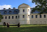 |
Bis heute sind mehrere Gebäude des Gutshofes erhalten, der zur Zeit der Grafen Plater erbaut worden war. Das alte Schloss, das sich am Rand der heutigen Grāfu Plāteru iela – am Ufer des Jāņupīte (Johannis –Flüsschens) befindet, ist 1759 im Barockstil erbaut. Der Architekt war der Venezianer Antonio Paraco. Später wurde es umgebaut, und nach dem Bau des Neuen Schlosses befand sich im untersten Stockwerk die Sommerresidenz der Familie der Plater, im zweiten und dritten Stockwerk war eine Bibliothek mit etwa 20 000 Einheiten. Diese wurde im zweiten Weltkrieg vernichtet, nachdem man einen Großteil des Bestandes in andere Residenzen der Grafen überführt hatte. Der Bau des neuen Schlosses des Gutshofes Krāslava (am oberen Uferabschnitt des Daugavatals) wurde 1765 begonnen (Architekt Domenico Paraco), anfänglich im Barock, aber um die Jahrhundertwende vom 18. zum 19. Jh. Wurde es im klassizistischen Stil umgebaut. Im Schloss entdeckte man einzigartige Rokoko-Wandgemälde mit Ansichten von Rom, die nach Vorlagen aus polnischen Schlössern in den 60er und 70er Jahren des 18. Jh. entstanden waren. Im Neuen Schloss war bis in die 70er Jahre des 20 Jh. eine Mittelschlule untergebracht. Das verlassene Schloss verwandelte sich bis vor kurzem noch allmählich in eine Ruine. Nun wurden umfangreiche Renovierungsarbeiten an der Fassade vorgenommen, und diese bietet nun einen gepflegten Anblick. Um das Schloss herum befindet sich ein im 18. Jh. geschaffener romantischer Landschaftspark – der Park der Grafen Plater (Grāfu Plāteru parks), der im Daugava Tal und diese kreuzenden Hängen angelegt worden war. Hier ist eine künstliche Grotte wieder hergestellt worden, und der Löwe – der Wächter des Schlosses, sowie eine Treppe an ihrer ursprünglichen Stelle, Parkwege und der Hof. |
|
|
|
Ein auf dem südostlichen Teil des Dombergs 1808 – 1810 gebautes Gebäude nennt man Wissenschaftsperle. Im Observatorium ist ein attraktives Museum eingerichtet. |
|


