
Naturobjekte in Estland

Was ist das Besondere an der Natur in Estland?
In Estland steht die beeindruckendste Felswand im Baltikum - das sogenannte nordestnische "Glitzern" (aus estnischer Sprache). Estland hat sein eigenes "Land der Buchten" - die Region Lahemaa mit ihrem Nationalpark, das "Land der Inseln" - die Insel Saaremaa und den Monzund-Archipel. Die Matsalu-Bucht ist eine der wichtigsten Raststätten für Vögel während ihrer Wanderung. In Estland gibt es einen der bekanntesten Einschlagkrater in Europa, es gibt die größten Wasserfälle und Felsbrocken im Baltikum, den Munamagi-Hügel - den höchsten Punkt im Baltikum, den Peipus-See - den fünftgrößten See in Europa - mit langen Hervorragende Fischertraditionen und die Vielfalt der Natur von West nach Ost, von Nord nach Süd.
Handle verantwortungsbewusst - folge dem Grünen Rat!
| Überblick | Details |
|---|---|
 |
Estland
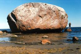
The Letipea Ehalkivi rockThis is the largest rock in the Baltic States and, according to some sources, in all of the segment of Northern Europe which was affected by the last Ice Age. Its size is 930 m3! The rock is 7.5 m high, 16.5 m long and 14 m high, with a circumference of 48.5 m. The rock resembles a huge pebble from a distance, and it is on the sandy and rocky beach. Depending on the season, it can be out in the water. The Ice Age carried the rock to its current location from the southern shore of Finland. It is made of pegmatite.
|
 |
Estland
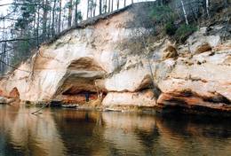
Ancient Võhandu River valleyThis is one of the most beautiful ancient river valleys in Estonia – 12 km long with nearly 40 revealed Devonian sandstone cliffs. Among these, the most important ones are Viira müür, Kalamatu müür, and Põdramüür.
|
 |
Estland
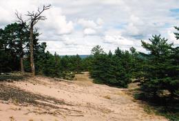
Aegna IslandThis is an entirely forested island in the Bay of Finland, ~14 km from Tallinn. A network of small pathways covers the entire island. Recommended hike along the seashore of the island, which will offer dunes, as well as a coastline that is sandy in some parts, rocky in others, and covered with reeds in still others (~9 km). A ferry boat will take you to the island from the Pirita port.
|
 |
Estland
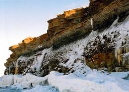
Felsen PakriDie mächtigste Steilküste im Baltikum (bis zu 24 m hoch). In den kalten Winter werden hier phantastische Gletscherstürze entstanden. Pakri Leuchtturm.  50 50
Leistungen
50km - Entfernung von der Hauptstadt |
 |
Estland
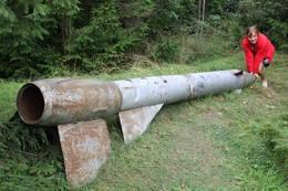
Kap JumindaDer weiteste Nordpunkt der Juminda Halbinsel mit einer Raketen-Attrappe der Sowjetarmee, der alten Grabstätten, dem Juminda-Leuchtturm und einem Denkmal für die Opfern des Zweiten Weltkriegs. 69
Leistungen
69km - Entfernung von der Hauptstadt |
 |
Estland
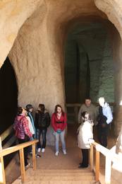
Ancient Piusa River valley and Piusa caveThe area of the ancient Piusa River valley that is between the villages of Vana-Vastseliina and Ignasõ is around 15 km long, features some substantial rapids, and offers a view of beautiful Devonian period cliffs. The largest, Härma müür, is 43 metres high and is the highest sandstone cliff in Estonia. There are caves from old mines in the village of Piusa. A small part of the mines, which have tunnels that are more than 10 km long in all, has been tured into a local museum.
LeistungenLeistungen - erholung
Fahrten mit Schiff/BootBoat from Vana-Vastseliina to Ignasõ (1 day, extreme boating, only during flood season). For more information: www.piusa.ee (available in English). 
NaturpfadHike down the river valley along its entire length (~20 km). |
 |
Estland
Suitsu tornis (Suitsu torn)Suitsu tornis celts 1979. g. kā pirmais Matsalu rezervāta metāla tornis. To atjaunoja 1998. g. Torņa augstums ir 21 m, tādēļ no tā paveras izcila dabas un kultūrainava uz Kazari deltas niedrājiem un blakus esošo Suitsu upi (Suitsu jõgi), kuras krastā ir uzceltas vairākas zvejnieku laivu būdas. |
 |
Estland
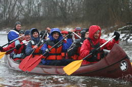
Wanderzentrum von Lahemaa matkakeskusWanderzentrum von Lahemaa beschäftigt sich mit Popularisierung von Naturschutz und Natururlaub – wir pflantzen Bäume, bauen und stellen Nistkatsen auf. Unseren Gästen bieten wir Kanuwanderungen, Moorwanderungen und Abenteuer auf Geländebogen- und Geländearmbrustpfad im Nationalpark Lahemaa an. Für gemütliches Relaxen gibt es einen Kaminraum und Sauna mit Badefass. 70
 1-12 1-12
Leistungen
70km - Entfernung von der Hauptstadt
1-12 Aktive Saisonmonate |
 |
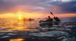
Estland
360° AbenteuerAngebote zum Natururlaub: Seekajakwanderungen im Sommer, Schneesschuhwanderungen im Moor im Herbst und im Winter, Kanuwanderungen auf Flüssen im Frühjahr 37
1-12
Leistungen
37km - Entfernung von der Hauptstadt
1-12 Aktive Saisonmonate |
 |
Estland
NaisaarThis is a forested island in the Bay of Finland which is the 6th largest Estonian island and is found 14 km to the N of Tallinn. Two decades ago it was a closed zone, because the Soviet Union had a highly secretive manufacturing plant for maritime mines here.
LeistungenLeistungen - erholung
Radroutea route around the entire perimeter of the island (~20 km). A ferry boat will take you to the island from the Pirita port.
NaturpfadThere is a hiking route along the southern part of Naisaar Island (13 km), as well as a military route (10 km), a central route (11 km) 
Naturbeobachtung |
 |
Estland
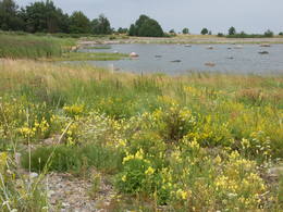
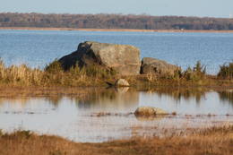
Neri akmeni (Näärikivid)Trīs lielāka izmēra laukakmeņi – aizsargājami dabas pieminekļi, kas atrodas Matsalu līča krastā starp Sāstnas (Saastna) un Metskjulas (Metsküla) ciemiem. Tuvējā ceļa malā ir izvietots informācijas stends un norādes, bet līdz akmeņiem var nokļūt pa iezīmētu taku. Pēc kāda tautas nostāsta, lielas vētras laikā, kas notikusi Jaungada naktī, lielais akmens sašķēlies trīs daļās. No tā arī cēlies vietvārds. Apkārtnē redzamās pļavas ir nozīmīga daudzu augu sugu dzīves vide un svarīga putnu ligzdošanas un atpūtas vieta. Šī iemesla dēļ taku drīkst apmeklēt tikai no 1. jūlija līdz septembra beigām. Akmeņi ir arī labi redzami no minētā ceļa. Tie ar ledāju atceļojuši no Turku (Somija) apkārtnes. 129
Leistungen
129km - Entfernung von der Hauptstadt |
 |
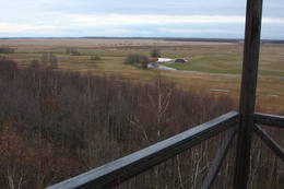
Estland
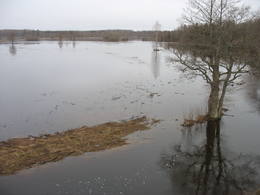
Leti tornis (Läti torn)Jēsū – Kepu ceļa malā pie Leti (Läti) ciema ir izveidots autostāvlaukums ar putnu vērošanas torni, no kura paveras skats uz Hallistes upes palieņu pļavām un tuvējā ciema apkārtni. Stipru palu laikā arī no šī torņa redzamā apkārtne (izņemot ceļus) var atrasties zem ūdens. Laba putnu vērošanas vieta. Läti tulkojumā no igauņu valodas nozīmē Latvija. |
 |
Estland
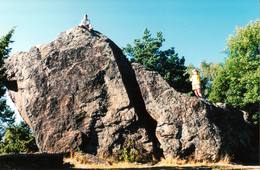
Stein Jaani - ToomaEiner der größten Feldsteine im Baltikum (bis 8 m). 72
Leistungen
72km - Entfernung von der Hauptstadt |
 |
Estland
Reimann Retked NaturtourenIm Angebot Naturtouren: Flosswanderungen im Frühjahr, Kajaktouren im Sommer (beim Wunsch auch inklusive Biberbeobachtung), ganzjährige Schneeschuhwanderungen in den Moorgebieten von Estland, im Winter Kick-Sled Touren. Erfahrene Wanderführer erzählen spannende Geschichten über die Natur und Kultur von Estland. 34
1-12
Leistungen
34km - Entfernung von der Hauptstadt
1-12 Aktive Saisonmonate |
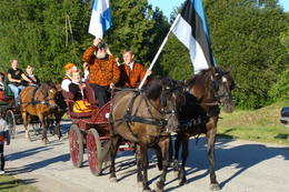 |
Estland
Reiterhof Tihuse altertümlicher KulturpfadReiterhof Tihuse bietet Reiten (von der Kutschefahrt bis zu Ausritte) und Beherbergung an. 148
1-12
Leistungen
148km - Entfernung von der Hauptstadt
1-12 Aktive Saisonmonate |
 |
Estland
Kidevas (Kiideva) putnu verosanas platformasPirmā ir uzcelta uz vienstāvīgā apmeklētāju centra jumta. No tās paveras plašs skats uz Kīdevas ciemu, ostu un niedrēm apaugušo Matsalu līča ziemeļdaļu. Austrumos no šīs atrodas vēl viena - divstāvīga putnu vērošanas platforma. No Kīdevas līdz Puisei gar Matsalu līča var doties pārgājienā pa 5 km garo dabas taku. To izejot, novēroto putnu sugu klāsts noteikti būs lielāks! |
 |
Estland
Kulturerbe-Fahrradroute von KoivaSeit Herbst 2010 gibt es am Fluss Koiva (Grenzfluss zwischen Estland und Lettland) eine 60 km lange Fahrradroute, die Kulturerbeobjekte beider Staaten präsentiert. Die Route beginnt im Parkplatz am Berg Tellingumäe parklast, an den beiden Enden und am Grenzübergang sind Rastplätze und Karten. Wegweiser auf den Kreuzungen zur Navigation vorhanden, ausserdem sind die Sehenswürdigkeiten etwas abseits leicht zu finden. Beschreibungen bei den Objekten sind auf Estnisch, Lettisch und Englisch. Im Startpunkt beginnt auch eine andere 18 km lange Route. 267
1-12
Leistungen
267km - Entfernung von der Hauptstadt
1-12 Aktive Saisonmonate |


