
Naturobjekte in Estland

Was ist das Besondere an der Natur in Estland?
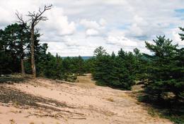
In Estland steht die beeindruckendste Felswand im Baltikum - das sogenannte nordestnische "Glitzern" (aus estnischer Sprache). Estland hat sein eigenes "Land der Buchten" - die Region Lahemaa mit ihrem Nationalpark, das "Land der Inseln" - die Insel Saaremaa und den Monzund-Archipel. Die Matsalu-Bucht ist eine der wichtigsten Raststätten für Vögel während ihrer Wanderung. In Estland gibt es einen der bekanntesten Einschlagkrater in Europa, es gibt die größten Wasserfälle und Felsbrocken im Baltikum, den Munamagi-Hügel - den höchsten Punkt im Baltikum, den Peipus-See - den fünftgrößten See in Europa - mit langen Hervorragende Fischertraditionen und die Vielfalt der Natur von West nach Ost, von Nord nach Süd.
Handle verantwortungsbewusst - folge dem Grünen Rat!
| Überblick | Details |
|---|---|
 |
Estland
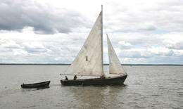
Lustfahrten mit Kale-SegelbootKale ist ein traditionelles Trawlerboot aus Holz, das auf dem Võrtsjärv eingesetzt wurde und das man wegen seines graziösen Aussehens oft auch für Vergnügungsfahrten nutzte. Das schlanke Segelboot hat zwei dreieckige Segel. Mit Unterstützung der Stiftung Võrtsjärve SA wurde im Jahr 2005 das Kale-Segelschiff „Paula“ 2009 das Kale-Segelschiff „Liisu“ angefertigt. Ein Kale-Segelschiff bietet ein echtes Erlebnis auf traditionellste Weise an. Auf Vorbestellung gibt es Fischsuppe und frischen Räucherfisch.  181 181
 5-9 5-9
Leistungen
181km - Entfernung von der Hauptstadt
5-9 Aktive Saisonmonate |
 |
Estland
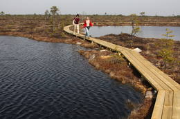
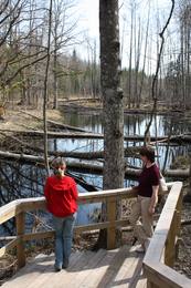
Nationalpark Soomaa und BesucherzentrumDer Nationalpark Soomaa wurde im Jahr 1993. zum Schutz der Hochmoore, artenreichen Sumpfwiesen, und Wälder gegründet. Auskunft über Wanderpfade und Dienstleistungen bekommen sie vom Besucherzentrum, hied gibt es auch eine ständige Exposition und Programme. Beim Besucherzentrum beginnt der Biber-Lehrpfad. Charakteristisch für den Park ist die sogenannte „fünfte Jahreszeit“ im März-April. In dieser Zeit kommt es regelmäßig zu Überflutungen.Während Hochwassers werden Kanu- und Einbaumtouren angeboten. (www.soomaa.com). Nationalpark Soomaa ist einziger Ort auf der Welt, wo man erlernen kann, wie Einbaum-Boote angefertigt werden und auch selbst an Workshops teilnehmen kann. Leistungen
150km - Entfernung von der Hauptstadt
1-12 Aktive SaisonmonateLeistungen - erholung
Angeln
LanglaufDuring the winter, there is cross-country skiing and hikes across frozen swamps. The visitor centre is in Tõramaa. For more information: www.soomaa.com (available in English). 
Fahrten mit Schiff/BootCanoeing is possible on flooded territories and down the rivers of the park. 
NaturpfadWalking tours in the park
NaturpfadHike the area in the presence of a guide, go “bog-shoeing”, hike the Riisa swamp trail (5 km, with watching tower), the Ignatsi trail (4.5 km, with watching tower), the Beaver information trail (3 km), the Tõramaa trail (2.5 km, with watching tower), and other trails and routes in the park. 
NaturbeobachtungYou can go on a beaver safari and look for other animals in the company of a guide. |
 |
Estland
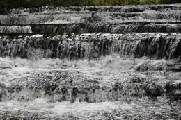
Nemmeveski udenskritums (Nõmmeveski juga)No vairākiem parka ūdenskritumiem noteikti ir jāapmeklē divi. 1,2 m augstais vienpakāpes Nemmeveski ir izveidojies uz Valgejegi upes (Valgejõgi), vietā kur tā šķērso Ziemeļigaunijas glintu. Šeit Valgejegi atgādina krāčainu (īpaši – pavasaros) kalnu upi, kas plūst pa vairākus metrus augstu klinšu ieskautu kanjonu. Palu laikā šo upes posmu ir iecienījuši ekstrēmie ūdenssporta veidu cienītāji. Pie ūdenskrituma un tālāk pa upi lejup redzamas ap 1920. g. celtās hidroelektrostacijas konstrukciju paliekas. |
 |
Estland
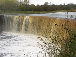
Wasserfall JägalaEins der eindrucksvollen Wasserfälle Estlands (ung. 8 m), „wiedererlebt” nach den reichlichen Niederschlägen und im Früfling bei Hochwasser. |
 |
Estland
Sõrve säärDie Südspitze der Insel Saaremaa – eine aus Geröll in der Irbenstraße langgestreckte Landzunge. Militärbefestigungen, Leuchtturm (1960), Vogelbeobachtungsort. 270
Leistungen
270km - Entfernung von der Hauptstadt |
 |
Estland
NaisaarThis is a forested island in the Bay of Finland which is the 6th largest Estonian island and is found 14 km to the N of Tallinn. Two decades ago it was a closed zone, because the Soviet Union had a highly secretive manufacturing plant for maritime mines here.
LeistungenLeistungen - erholung
Radroutea route around the entire perimeter of the island (~20 km). A ferry boat will take you to the island from the Pirita port.
NaturpfadThere is a hiking route along the southern part of Naisaar Island (13 km), as well as a military route (10 km), a central route (11 km)
Naturbeobachtung |
 |
Estland
Burgberg OtepääEine sehr ausgeprägte und vom Mensch ausgebaute Reliefgestaltung mit breiter Sicht aufs Umland. Auf dem Burgberg steht die Ruine der 1224 vom Bischof Herman gebauten Burg. In den Ausgrabungen wurde die älteste Schußwaffe der Welt gefunden. 225
Leistungen
225km - Entfernung von der Hauptstadt |
 |
Estland
Bebru taka (Koprarada)Divus kilometrus garās lokveida takas sākums ir meklējams pie Somā nacionālā parka apmeklētāju centra (atklāts 2000. gadā) – Tēramā ciemā. Tā ved gar Mardu strauta (Mardu oja) krastu, kur krustām šķērsām ir sakrituši bebru nogāztie koki, radot diezgan juceklīgu skatu. Apmeklētāju centrā var iegūt nepieciešamo informāciju, noskatīties videofilmu un nacionālajam parkam veltītu ekspozīciju. 171
Leistungen
171km - Entfernung von der Hauptstadt |
 |
Estland
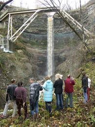
Saka-Ontika-Toila-pank (cliff)This is a cliff with various levels. Known as the North Estonian cliff, it stretches all along the shore of the Bay of Rīga in Estonia, including some of the local islands. The most expressive part in geological and landscape terms is the Saka-Ontika-Toila cliff, which is around 22 km long and offers an unusual natural environment. The cliff is as much as 53 m high, and it has a fairly virginal forest along its slopes. The layers of clay, sandstone, limestone, etc., come from the Cambrian and Ordovician periods. The Valaste juga (Valaste waterfall) is 24 metres high. After a longer period of freezing temperatures, the waterfall has a particularly impressive appearance. Seasonal waterfalls (8-10 m) can be found near the villages of Ontika and Toila.
LeistungenLeistungen - erholung
RadrouteBike from Saka to Taoil (20 km) along the road that is at the top of the cliffs.
NaturpfadHike along the seashore during the season when trees are bare, moving from Saka to Toila (~22 km).
NaturbeobachtungThere is an impressive viewing platform at the Valaste waterfall. |
 |
Estland
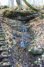
Joaveski udenskritumi (Joaveski joastik)Krāčains Lobu upes (Loobu jõgi) posms pie Joaveski ciema, kur ~ 160 m garumā upes gultnē, tai šķērsojot Ziemeļigaunijas glintu, izveidojušās izmēros nelielas, tomēr ļoti ainaviskas un skaistas 0,5 – 1 m augstas ūdenskritumu kaskādes. 1898. g. šeit uzcēla hidroelektrostaciju, kuras atliekas ir redzamas upes labajā krastā. Iecienīta pavasara laivotāju treniņu vieta. |
 |
Estland
Saleveres Salumegi kalns (Salevere Salumägi)Litorīnas jūras laikā (pirms ~ 6000 gadiem) Saleveres Salumegi kalns bija sala, bet mūsdienās tas kā izteikta kāple (īpaši - ziemeļu pusē) paceļas virs Piejūras līdzenuma. Salumegi ziemeļu pusē slejas 4 - 5 metrus augsts kaļķakmens atsegums – silūra perioda (> 400 mlj. gadu) koraļļu rifa paliekas, kuru noskalojuši Litorīnas jūras viļņi. Atseguma piekājē izplūst Acu avots, kam piedēvē dziednieciskas īpašības. Salumegi apskates nolūkos izveidota lokveida taka (1,5 km). No kalna augšas paveras labs skats uz Matsalu līci. Šeit atradies arī sens pilskalns. 132
Leistungen
132km - Entfernung von der Hauptstadt |
 |
Estland
The Otepää Nature ParkThis park is found in the Otepää highlands and offers an outstanding example of how the terrain of a protected natural territory can be used for recreation, sports and active leisure. The infrastructure of the park is perfect for such activities and is of a high level of quality.
LeistungenLeistungen - erholung
LanglaufDuring the winter, you can ski the 63-km Tartu marathon trail, which crosses the park.
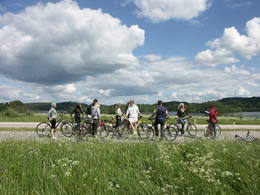
RadrouteBike around Lake Pühajärv from the centre of Otepää (~20 km), or ride from Otepää to Kääriku (11 km).
NaturpfadHike around Lake Pühajärv (12 km), hike the Kekkose hiking route (14 km), or hike the Murrumetsa hiking trail (3.5 km). Bike around Lake Pühajärv from the centre of Otepää (~20 km), or ride from Otepää to Kääriku (11 km).
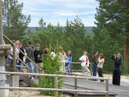
NaturbeobachtungThere are viewing towers at Harimägi and in the hills of Kuutsemägi, near the Otepää ski jump, at Väike Munamägi, and near the Otepää castle hill. For more information: www.otepaaloodus.ee (available in English). |
 |
Estland
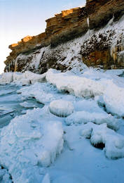
Pakri peninsulaAt the end of the Pakri peninsula is the most visually impressive shoreline cliff in the Baltic States – the Pakri cliff (Pakri pank), which is as much as 24 metres high. During cold winters, streams which flow from the layers of limestone cliffs form fantastic and unusual shapes of ice.
|
 |
Estland
LuitemaaThe word “Luitemaa” means “land of the dunes” in Estoninan. This coastline territory stretches for 13 km between Vöiste and Häädemeste with shallow waters, large coastal plains, Estonia’s highest dunes, and the Tokuse swamp (Tokuse raba). There are lots of birds here.
|
|
|
Estland
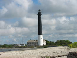
Insel HiiumaaDie zweitgrößte Insel Estlands mit breiter Waldung, Sand- und Steinstränden und einem der ältesten Leuchttürme Europas. 132
Leistungen
132km - Entfernung von der Hauptstadt |
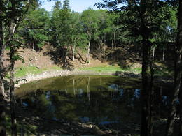 |
Estland
Meteoritenfeld von Kaali, Besucherzentrum, Wirtshaus KaaliDer Meteoriteneinschlag auf Insel Saaremaa liegt ungefähr 7500-7600 Jahre zurück und verursachte einen Krater von 110 m Durchmesser und 22 m Tiefe und 8 weiter kleine Krater. In der Rangliste der Riesenkrater der Welt liegt der Kaali Krater an achter Stelle. Das Kaali Meteoritenkraterfeld auf Saaremaa ist das seltenste Naturdenkmal Estlands und gleichzeitig das eindrucksvollste Kraterfeld in Eurasien. Auf dem Kraterfeld befindet sich das Besucherzentrum von Kaali samt dem Museum für Meteoritik und Kalkstein, einem Konferenzsaal und dem Hotel. Im Museum sind echte Meteoritenstücke ausgestellt. Im Hotel sind kompfortable Zimmer, nebenan befindet sich historisches Wirtshaus Kaali. 204
1-12
Leistungen
204km - Entfernung von der Hauptstadt
1-12 Aktive Saisonmonate |
 |
Estland
Wanderzentrum von Lahemaa matkakeskusWanderzentrum von Lahemaa beschäftigt sich mit Popularisierung von Naturschutz und Natururlaub – wir pflantzen Bäume, bauen und stellen Nistkatsen auf. Unseren Gästen bieten wir Kanuwanderungen, Moorwanderungen und Abenteuer auf Geländebogen- und Geländearmbrustpfad im Nationalpark Lahemaa an. Für gemütliches Relaxen gibt es einen Kaminraum und Sauna mit Badefass. 70
1-12
Leistungen
70km - Entfernung von der Hauptstadt
1-12 Aktive Saisonmonate |


