
Naturobjekte in Estland

Was ist das Besondere an der Natur in Estland?
In Estland steht die beeindruckendste Felswand im Baltikum - das sogenannte nordestnische "Glitzern" (aus estnischer Sprache). Estland hat sein eigenes "Land der Buchten" - die Region Lahemaa mit ihrem Nationalpark, das "Land der Inseln" - die Insel Saaremaa und den Monzund-Archipel. Die Matsalu-Bucht ist eine der wichtigsten Raststätten für Vögel während ihrer Wanderung. In Estland gibt es einen der bekanntesten Einschlagkrater in Europa, es gibt die größten Wasserfälle und Felsbrocken im Baltikum, den Munamagi-Hügel - den höchsten Punkt im Baltikum, den Peipus-See - den fünftgrößten See in Europa - mit langen Hervorragende Fischertraditionen und die Vielfalt der Natur von West nach Ost, von Nord nach Süd.
Handle verantwortungsbewusst - folge dem Grünen Rat!
| Überblick | Details |
|---|---|
 |
Estland
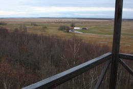
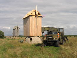
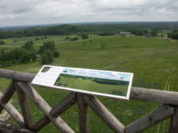
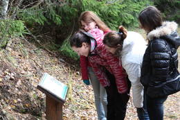
Moorpfad ViruEin 3,5 km langer Pfad quert den Viru Moos in Richtung Süd–Nord. Von einem Holzaussichtsturm eröffnet sich einen Blick auf eine typische Hochmoorlandschaft mit einigen Seen, Aushöhlungen und morastigen Stellen.  56 56
Leistungen
56km - Entfernung von der Hauptstadt |
 |
Estland
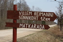
Paunas taka (Pauna rada)Kultūrvēsturiska taka (garums ~ 2 km) Tipu (Tipu) ciemā, kas iepazīstina ar vairākiem interesantiem objektiem: veco skolu (1931. g.), Hallistes upi, pirti un Paunas saimniecību, kurā dzimis viens no Igaunijas nacionālās kustības līderiem Villems Reimans (1861. – 1917.). |
 |
Estland
Moor TolkuseDurch das höchste Dünen-Massiv Estlands und den Moor führt der Lehr-Wanderweg. Blick vom Aussichtsturm bis auf die Insel Kihnu. 175
Leistungen
175km - Entfernung von der Hauptstadt |
 |
Estland
Anhöhe OtepääEine der drei Anhöhen im Südestland mit malerischen Hügeln und schönen Aussichtsplätzen. Im „Zentrum” der Anhöne legt sich der mit Buchten reiche Pühajärv See (Heiliger See). 230
Leistungen
230km - Entfernung von der Hauptstadt |
 |
Estland
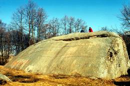
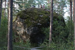
Muuga Kabelikivi rockThis is the second largest rock in the Baltic States in terms of size (728 m3). It is the only rock in the Baltic States with this form and size. It is 7 m high, 19 m long, 11 m wide, and 58 m in perimeter. Kabelikivi looks like a cliff that is halfway sunk into the earth. During the Ice Age, the rock “travelled” to this location from southern Finland. It is made of granite, and there are two other very impressive rocks alongside it.
|
 |
Estland
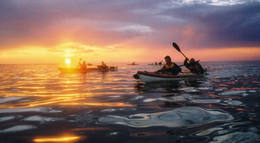
Reimann Retked NaturtourenIm Angebot Naturtouren: Flosswanderungen im Frühjahr, Kajaktouren im Sommer (beim Wunsch auch inklusive Biberbeobachtung), ganzjährige Schneeschuhwanderungen in den Moorgebieten von Estland, im Winter Kick-Sled Touren. Erfahrene Wanderführer erzählen spannende Geschichten über die Natur und Kultur von Estland. 34
 1-12 1-12
Leistungen
34km - Entfernung von der Hauptstadt
1-12 Aktive Saisonmonate |
 |
Estland
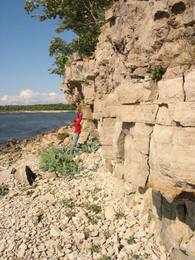
Steilküste TürisaluBis zu 30 m hohe Kalk- und Sandsteinfelsen an der Küste des Finnischen Meerbusens. Ein Aussichtsplatz. |
 |
Estland
The Vooremaa field of drumlinsThis is the most visually impressive drumlin field in the Baltic States, and it is close to the village of Tabivere. The drumlins were established by ice glaciers, and they point in the direction in which the ice moved long ago. In terms of their appearance, the drumlins resemble loaf-shaped hillocks. From their “backs,” there are lovely views of the local landscape and the lakes that are around the area. The visitor centre is in the village of Äksi.
|
 |
Estland
Insel KihnuDer in die UNESCO-Liste des Welterbes eingetragene Kulturraum (www.kultuuriruum.ee) von Kihnu ist eine Mischung aus Gegenwart und Vergangenheit. Im Museum von Kihnu sind Werzeug, Kleidungsstücke, Handarbeit und Möber exponiert. Der Bauernhof Metsamaa ist ein traditioneller Haushalt, wo sie die Kontraste des Insellebens näher erkundigen können. Hier sind für Kihnu typische Haushaltsgeräte, Tracht und Handarbeit zum Ansehen ausgestellt. Geführte Exkursionen auf der Insel veranstaltet Kihnurand AS (www.kihnurand.ee). 180
1-12
Leistungen
180km - Entfernung von der Hauptstadt
1-12 Aktive Saisonmonate |
 |
Estland
Pakri islandsThere are two islands here – Suur Pakri (Great Pakri) and Väike Pakri (Small Pakri). They are 3 km to the West of Paldiski. During Soviet times, the islands were used for target practice by the Soviet air force, which is seen in the many craters and spent munitions that can be found on the island even today. The island is mostly covered with scrappy areas of juniper, but the limestone cliffs at the northern and north-eastern end of the island are quite impressive – as much as 6 m in height.
|
 |
Estland
Suitsu tornis (Suitsu torn)Suitsu tornis celts 1979. g. kā pirmais Matsalu rezervāta metāla tornis. To atjaunoja 1998. g. Torņa augstums ir 21 m, tādēļ no tā paveras izcila dabas un kultūrainava uz Kazari deltas niedrājiem un blakus esošo Suitsu upi (Suitsu jõgi), kuras krastā ir uzceltas vairākas zvejnieku laivu būdas. |
 |
Estland
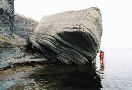
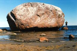
The Letipea Ehalkivi rockThis is the largest rock in the Baltic States and, according to some sources, in all of the segment of Northern Europe which was affected by the last Ice Age. Its size is 930 m3! The rock is 7.5 m high, 16.5 m long and 14 m high, with a circumference of 48.5 m. The rock resembles a huge pebble from a distance, and it is on the sandy and rocky beach. Depending on the season, it can be out in the water. The Ice Age carried the rock to its current location from the southern shore of Finland. It is made of pegmatite.
|
 |
Estland
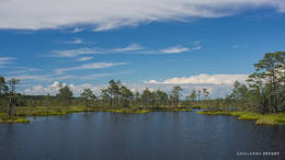
Nationalpark LahemaaLahemaa bedeutet auf estnisch “Land der Buchten“. Der erste Nationalpark im Baltikum (1971). Der Park wurde für den Schutz der biologischen Vielfalt, Inseln, geologischen Objekte, archeologischen Denkmäler, Landgüter, Fischerdörfer u.a. gegründet. Leistungen
50km - Entfernung von der HauptstadtLeistungen - erholung
LanglaufFor cross-country skiers, the Käsmu peninsula is perfect during the season. 
RadrouteFor bikers, there’s the Käsmu peninsula (~10 km), the route Loksa-Pärispea-Viinistu-Kasispea on the Pärispea peninsula (here you will find the highest rock in the Baltic States – the Jaani-Tooma rock (kivi, 7.8 metres high). 
NaturpfadYou can hike a wooden train over the Viru swamp (Viru raba, 3.5 km), another trail on the Käsmu peninsula (~15 km), and the Pikanõmme-Majakivi trail (4.5 km), along which you will find the third largest rock in the Baltic States – the so-called House Rock (Majakivi), which has a size of 584 m3. We also suggest the informational Altja trail (3 km). 
NaturbeobachtungThere are viewing towers in the Viru raba swamp and along the Piaknõmme-Majakivi trail. There is a visitor centre at Palmse. |
 |
Estland
Aegna IslandThis is an entirely forested island in the Bay of Finland, ~14 km from Tallinn. A network of small pathways covers the entire island. Recommended hike along the seashore of the island, which will offer dunes, as well as a coastline that is sandy in some parts, rocky in others, and covered with reeds in still others (~9 km). A ferry boat will take you to the island from the Pirita port.
|
 |
Estland
Vilsandi sala (Vilsandi saar)Vilsandi nacionālā parka „sirds” un divpadsmitā lielākā Igaunijas sala (garums - 6 km, platums – 2 km). Tā ir ļoti „jauna” sala, kas sākusi veidoties pirms ~ 2000 gadiem zemes garozas celšanās rezultātā, savienojoties divām salām, kas noticis pirms ~ 350 gadiem. Cilvēki salu sāka apdzīvot 18. gs. un to galvenā nodarbe bija zvejniecība, kuģu būve, nelielā apjomā – lauksaimniecība. Līdz 2. pasaules karam te bija ap 200 iedzīvotāju, kuri vēlāk salu bija spiesti pamest PRSR pierobežas režīma zonas dēļ. Nozīmīgu Vilsandi daļu aizņem mežs un kadiķu lauki. To visā garumā šķērso grantēts - zemes ceļš ar atzariem uz jūras krastu. Salu ar kājām var izstaigāt vairāku stundu laikā, iepazīstot vietējo apbūvi (daļa arī mūsdienās celtas ēkas) un Tolli sētu, kur pēc nostāstiem dzīvojis nīderlandiešu jūras braucējs Johans Dolls, kā arī vējdzirnavas. Noteikti ir jāaiziet līdz salas rietumu krastam, kur atrodas Vilsandi bāka un bākas uzrauga saimniecības ēkas. No šejienes ir labi redzamas Vaikas salas. Šodien uz salas pastāvīgi (visa gada garumā) dzīvo tikai trīs cilvēki. |
 |
Estland
Themenpark der SchildbürgerIm ehemaligen Gutshofpark von Müüsleri befindet sich eigenartiger Themenpark "Dorf der Schildbürger". Die Attraktionen im Park sind verbunden mit den Sagen von Schildbürgern, die schon vor 400 Jahren in Deutschland bekannt waren. Schildbürger sind Figuren aus einem Witzbuch, berühmt durch ihr unzweckmässige, irrsinnige Tätigkeit und Streiche. Im Themenpark werden humorvolle Erlebnistouren, Basteln, Verpflegung (für Gruppen auf Voranmeldung), Shopping und Zelten angeboten. 107
1-12
Leistungen
107km - Entfernung von der Hauptstadt
1-12 Aktive Saisonmonate |
 |
Estland
Erdi taka (Öördi rada)1,2 km gara taka, kas pa purvainu mežu aizved līdz Ērdi purvam (Öördi raba) un tā austrumu daļā esošajam Ērdi ezeram (Öördi järv), pie kura izveidota atpūtas un peldvieta. |
 |
Estland
Tuhala Karst area, Witch’s wellOne of the largest karst areas in Estonia is found here. The unique Witch’s well is one of the most interesting parts of this area. During spring floods (not every year, and for only a short period of time), the well erupts with underground river waters to create an unusually powerful karst stream that can pump out as much as 100 litres per hour.
|
 |
Estland
Eldas klints (Elda pank) un pussalaNacionālā parka dienvidrietumdaļā jūrā iestiepjas Eldas pussala – skaists un ļoti omaļš ar kadiķu mežu (alvāriem) noaudzis zemes pleķītis ar interesantu jūras krastu, kur atsedzas silūra perioda nogulumieži. No pussalas gala, kurā slejas vecs Padomju armijas robežsargu tornis (apmeklējumam bīstams!), paveras visaptverošs skats uz Vilsandi salu (atpazīstama pēc bākas), Lonalaidas salu (Loonalaid) – otru lielāko Vilsandi arhipelāgā, Salavu (Salava) un citām mazākām saliņām. Dabas mīļotāji var uzmeklēt Eldas klinti (Elda pank) – ~ 2 m augstu un 0,4 km garu atsegumu, kura piekājē var atrast interesantas ūdens izskalotas fosilijas. 261
Leistungen
261km - Entfernung von der Hauptstadt |
 |
Estland
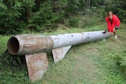
Kap JumindaDer weiteste Nordpunkt der Juminda Halbinsel mit einer Raketen-Attrappe der Sowjetarmee, der alten Grabstätten, dem Juminda-Leuchtturm und einem Denkmal für die Opfern des Zweiten Weltkriegs. 69
Leistungen
69km - Entfernung von der Hauptstadt |
 |
Estland
Leti tornis (Läti torn)Jēsū – Kepu ceļa malā pie Leti (Läti) ciema ir izveidots autostāvlaukums ar putnu vērošanas torni, no kura paveras skats uz Hallistes upes palieņu pļavām un tuvējā ciema apkārtni. Stipru palu laikā arī no šī torņa redzamā apkārtne (izņemot ceļus) var atrasties zem ūdens. Laba putnu vērošanas vieta. Läti tulkojumā no igauņu valodas nozīmē Latvija. |
 |
Estland
Stein MajakiviDer dritgrößte Feldstein im Baltikum (584 m3, 7 m hoch, Durchmesser bei dem Grund – 32 m ). Auf estnisch bedeutet „Hausstein”. Befindet sich am Rande des Pikanõmme – Majakivi Pfades (4,5 km lang). 60
Leistungen
60km - Entfernung von der Hauptstadt |
 |
Estland
Torna kalns (Tornimägi)Karulas augstienes augstākais reljefa punkts (137 m.vjl.), kas virs tuvākās apkārtnes paceļas par ~ 60 m. Torņa kalnā ir uzbūvēts skatu tornis ar ļoti plašu apkārtskatu. Uz tā platformas ir novietoti panorāmas fotoattēli, kuros atzīmēti zīmīgākie plašākā apkaimē redzamie objekti – apdzīvotas vietas, pilskalni, baznīcu torņi u.c. Turpat izveidota atpūtas vieta un meklējams Rebases ainavu takas sākums. 260
Leistungen
260km - Entfernung von der Hauptstadt |
 |
Estland
Kusnemmes pussala (Kuusnõmme poolsaar)Ap 6 km garā pussala ir vieta, kur jānokļūst tiem, kas grasās doties vienā no neparastākajiem pārgājieniem pāri jūras šaurumam. Cauri Kūsnemmes pussalai līdz tās ziemeļu daļai iet šaurs un ļoti līkumains grants ceļš (ar garāku tūristu autobusu jābrauc lēni un uzmanīgi), kura galā izveidots autostāvlaukums, neliels namiņš, kur patverties lietus un vēja laikā, kā arī informācijas stends. Turpat redzamas divas Padomju armijas „KRAZ” tipa automašīnas. Lai sasniegtu robežkontroles posteni, Padomju robežsargi brauca pa jūru un mazajām saliņām, kas kā pērļu virtene savieno Kūsnemmes pussalas galu ar Vilsandi salas dienviddaļu. Turpat divas desmitgades pēc Igaunijas neatkarības atjaunošanas „KRAZ” automašīnu kravas kastēs vasaras laikā uz Vilsandi vizināja tūristus, taču spēkrati savu mūžu ir nokalpojuši un unikālais piedāvājums vairs nav spēkā! Ko darīt? Pa mazajām saliņām uz Vilsandi var doties ar kājām. To var īstenot tikai siltā laikā, kad nav gaidāms stiprs vējš un ir zināma laika prognoze vismaz divām tuvākajām dienām. Kā sava veida orientieris var kalpot augstsprieguma elektrolīnija. Kopumā ir jārēķinās arī ar 1 h 40 – 2 h ilgu un ~ 4 km garu gājienu. Dziļākā vieta (ja ietur pareizo „kursu”) atrodas pārgājiena sākumdaļā, kur starp saliņām izveidots laivu ceļš - ~ 1 m dziļa vieta atkarībā no vēja virziena un ūdens līmeņa. Zināmu priekšstatu par maršrutu sniegs redzamā ainava, kas paveras no skatu torņa. Kaut arī šis maršruts tiek reklamēts dažādos informatīvajos materiālos, atbildību par tā veikšanu uzņemas katrs pats! 257
Leistungen
257km - Entfernung von der Hauptstadt |
 |
Estland
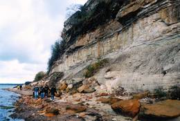
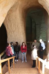
Ancient Piusa River valley and Piusa caveThe area of the ancient Piusa River valley that is between the villages of Vana-Vastseliina and Ignasõ is around 15 km long, features some substantial rapids, and offers a view of beautiful Devonian period cliffs. The largest, Härma müür, is 43 metres high and is the highest sandstone cliff in Estonia. There are caves from old mines in the village of Piusa. A small part of the mines, which have tunnels that are more than 10 km long in all, has been tured into a local museum.
LeistungenLeistungen - erholung
Fahrten mit Schiff/BootBoat from Vana-Vastseliina to Ignasõ (1 day, extreme boating, only during flood season). For more information: www.piusa.ee (available in English).
NaturpfadHike down the river valley along its entire length (~20 km). |
 |
Estland
The Karula National ParkThis park is in a region of hillocks in the Karula highlands, and Lake Ähijärve is at its centre. The park offers a cultural environment of small farms, and it was set up to protect the unique cupola-shaped hillocks of the area. Main attractions: Scenic Lake Ähijärv (176ha), Rebasemõisa Tornimägi hill (137.8 m above sea level), undulating landscapes. Leistungen
280km - Entfernung von der HauptstadtLeistungen - erholung
Angeln
RadrouteBike the route Ähijärve-Peräjärve-Kolski-Rebasemõisa-Kaika-Ähijärve (26 km).
NaturpfadHike the Ähijärve nature trail (3.5 km), the Rebase landscape trail (7 km), or the Peräjärve nature trail (4 km).
NaturbeobachtungThere are viewing towers on Tornimägi hill and at Mäekonnu. The visitor centre is in the village of Ähijärve. For more information: www.karularahvuspark.ee (available in English). |
 |
Estland
Insel KassariDie fünftgrößte Insel Estlands. Naturpfade, Vogelbeobachtungsturm, Kapelle von Kassari (18. Jh.) und Sääre tirp – eine 3 km schmale weit ins Meer reichende Landzunge aus Geröll, auf der man spazierengehen kann. Leistungen
150km - Entfernung von der HauptstadtLeistungen - erholung
RadrouteBike the route Käina-Orjaku-Kassari-Esiküla-Käina (22 km).
NaturpfadThe Orjaku nature trail (up to 2 km); the Sääre tirp – a 3-km hike along a rocky path on the southern end of the Kassari Island;
NaturbeobachtungBirdwatchers will enjoy the Bay of Käina, where a colony of great cormorants and other water birds can be found. There is a bird-watching tower at Orjaku, as well as a viewing platform at the Bay of Vemla (Vaemla laht). |
|
|
Estland
Kap TahkunaDer weiteste Nordpunkt der Insel Hiiumaa. Der höchste Leuchtturm Estlands aus Roheisen (1873 – 1875) und das Denkmal zur Errinerung an die bei dem Unglück des Schiffes ‘Estonia” Umgekommenen. 175
Leistungen
175km - Entfernung von der Hauptstadt |
 |
Estland
Perajerva meza taka (Pärajärve metsarada)Četrus kilometrus gara marķēta lokveida taka, kas ved pa lielāku meža masīvu, iepazīstina ne tikai ar augiem un dzīvniekiem, bet arī mežsaimniecības tradīcijām. Takas sākums atrodas pie nelielā Perejerves ciema, uz kuru paveras labs skats no tuvējā paugura. Pie autostāvlaukuma izveidota atpūtas un piknika vieta. |
 |
Estland
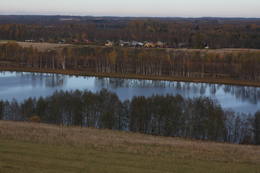
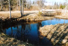
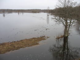
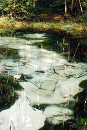
The blue streams of SaulaThree little lakes can be found on the left bank of the Pirita River with many erupting “eyes” of streams, each with its own colour (bluish-green, white, dark). This puts together various colour combinations. These are often known as the most beautiful streams in Estonia. Some pump out as much as 20-30 litres of water per hour. It is said that the waters are good medical resources, particularly for the eyes. There are improvements in the area of tourists.
|


