
Naturobjekte in Estland

Was ist das Besondere an der Natur in Estland?
In Estland steht die beeindruckendste Felswand im Baltikum - das sogenannte nordestnische "Glitzern" (aus estnischer Sprache). Estland hat sein eigenes "Land der Buchten" - die Region Lahemaa mit ihrem Nationalpark, das "Land der Inseln" - die Insel Saaremaa und den Monzund-Archipel. Die Matsalu-Bucht ist eine der wichtigsten Raststätten für Vögel während ihrer Wanderung. In Estland gibt es einen der bekanntesten Einschlagkrater in Europa, es gibt die größten Wasserfälle und Felsbrocken im Baltikum, den Munamagi-Hügel - den höchsten Punkt im Baltikum, den Peipus-See - den fünftgrößten See in Europa - mit langen Hervorragende Fischertraditionen und die Vielfalt der Natur von West nach Ost, von Nord nach Süd.
Handle verantwortungsbewusst - folge dem Grünen Rat!
| Überblick | Details |
|---|---|
 |
Estland
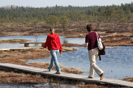
Kidevas (Kiideva) putnu verosanas platformasPirmā ir uzcelta uz vienstāvīgā apmeklētāju centra jumta. No tās paveras plašs skats uz Kīdevas ciemu, ostu un niedrēm apaugušo Matsalu līča ziemeļdaļu. Austrumos no šīs atrodas vēl viena - divstāvīga putnu vērošanas platforma. No Kīdevas līdz Puisei gar Matsalu līča var doties pārgājienā pa 5 km garo dabas taku. To izejot, novēroto putnu sugu klāsts noteikti būs lielāks! |
 |
Estland
Ignatsi pargajienu taka (Ignatsi matkarada)Taka iesākumā ved pa mežu ieskautu bijušo šaursliežu dzelzceļa līniju, pa kuru pagājušā gadsimta vidū izveda kokmateriālus. Tās tālākā daļa izmet nelielu loku pa Suistna purvu (Suistna raba), kur uzcelts skatu tornis ar izcilu sūnu purva ainavu ar nelieliem ezeriņiem. Takas garums vienā virzienā ir 4,5 km. |
 |
Estland
Insel SaaremaaDie größte Insel Estlands. Saaremaa heißt wörtlich übersetzt "Inselland". Der 3 km lange Damm verbindet Saaremaa mit der Insel Muhu. Auf dem Damm kann man sich mit dem Fahrrad bewegen.  160 160
Leistungen
160km - Entfernung von der Hauptstadt |
 |
Estland
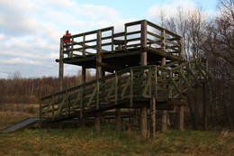
Kemu skatu tornis (Keemu vaatetorn)Meklējams Matsalu līča dienvidu krastā pie Kēmu ostas (Keemu sadam). Blakus sešus metrus augstajam metāla – koka tornim uzcelts neliels apmeklētāju centrs. Tāpat kā no Haeskas torņa, arī no šī paveras viena no izcilākajām Matsalu līča un tā piekrastes ainavām. Laba putnu vērošanas vieta migrāciju laikā. 129
Leistungen
129km - Entfernung von der Hauptstadt |
 |
Estland
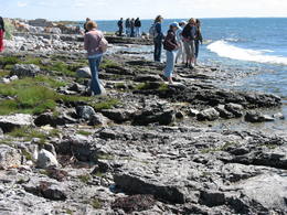
Mohni sala (Mohni saar)Igaunijas jūras ūdeņos ir saskaitīta 1521 sala! Salu sarakstā pēc platības (63 ha) ~ 2,5 km garā Mohni sala ieņem 38. vietu. Lai saudzētu salas trauslo veģetāciju (vietām nedaudz atgādina krūmainu tundru), tās vidusdaļā ir izveidotas koka laipas. Salas dienviddaļā atrodas sašaurinājums, kuru tāpat kā blakus esošo jūras krastu klāj viens no savdabīgākajiem Igaunijas akmeņu laukiem. Salas ziemeļos esošās Mohni bākas (Mohni tuletorn) celtniecība pabeigta 1871. g. un tās gaisma ir redzama 10 jūras jūdžu attālumā. Šī ir viena no skaistākajām Ziemeļigaunijas bākām! Līdz Mohni salai var nokļūt ar laivu (iepriekšēja pieteikšanās) no ~ 5 km attālās Vīnistu ostas (Viinistu sadam). Ar jūras laivu vai kajaku piemērotos apstākļos būs ~ 1h ilgs brauciens. Jārēķinās, ka uz salas nav pastāvīgo iedzīvotāju! Vīnistu ciemā apskatāms 2002. g. izveidotais Vīnistu mākslas muzejs (Viinistu kunstimuuseum). Apmeklētājus iespaidos ne tikai tā āriene, bet arī tapšanas vēsture. 76
Leistungen
76km - Entfernung von der Hauptstadt |
 |
Estland
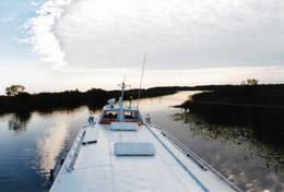
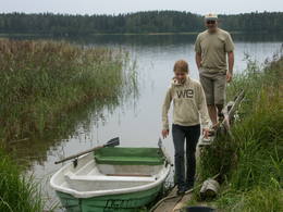
Tartu-PiirissaareThis is a quick boat ride from Tartu down the Emajõgi River to Piirissaare Island in Lake Peipsi (Peipsi järv). Along the lower reaches of the river are major wetlands which are of enormous importance for birds.
LeistungenLeistungen - erholung
Fahrten mit Schiff/BootTake the ship from Tartu to Piirissaare (65 km) and just enjoy the landscapes along the banks of the river. 
NaturbeobachtungThere is a viewing tower on Piirissaare Island. For more information: www.visittartu.com (available in English). |
 |
Estland
Hjupasares pargajienu taka (Hüpassaare matkarada)Iepazīstina ar Somā nacionālā parka lielākā purva – Kureso (Kuresoo) ziemeļaustrumu daļu, kur redzamas purva ezeriņu un lāmu ainavas. Takas sākumā atrodas igauņu komponista, ērģelnieka un folkloras vācēja Marta Sāra (Mart Saar) (1882. – 1963.) dzimtās mājas. To apkaimē pļavas apsaimnieko aitas. Lokveida takas garums ir 4,2 km. 169
Leistungen
169km - Entfernung von der Hauptstadt |
 |
Estland
The Endla ReserveThis reserve was set up to protect local swamps and surrounding wetlands. Please note that before you can visit the reserve, you must register with the local administration and visitor centre in the village of Tooma.
LeistungenLeistungen - erholung
NaturpfadThe Endla swamp trail (~2 km) with a viewing tower, and the Endla stream trail (6 km). Please note that before you can visit the reserve, you must register with the local administration and visitor centre in the village of Tooma. For more information: www.endlakaitseala.ee (available in English). |
 |
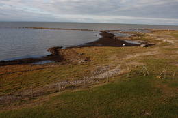
Estland
Skats uz Vaikas salam (Vaika saared)No Vilsandi bākas un tai tuvākās apkaimes ir labi saskatāmas leģendārās Vaikas salas. Tām ir piešķirts rezervāta statuss, tādēļ salas var apskatīt tikai no attāluma. Mazākā no saliņām - Kullipank ir tikai pārdesmit metrus diametrā. Tā ir jūras ūdeņu izrobots zemas un asas dolomīta klints fragments, kas klāts ar oļiem, nelieliem laukakmeņiem un kādu atsevišķi stāvošu lakstaugu. Domājams, ka vētru laikā tā pazūd zem jūras ūdens. Savukārt, Alumine Vaigas – Apakšējā Vaikas sala ir lielākā no sešām salām. Šīs salas diametrs ir ~ 150 m un tā paceļas vismaz kādus divus metrus virs jūras līmeņa. Uz salas ir bagātīga veģetācija un pat kāds zems krūms salas centrā. Redzami arī metru augsti atsegumi. Uz salas vēl joprojām atrodas 20. gs. sākumā celto „putnu māju” paliekas, kas bija domātas ligzdojošo putnu piesaistīšanai. |
 |
Estland
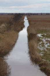
Kostivere karst fieldThis is one of Estonia’s most beautiful karst fields, covering 125 hectares which feature different karst processes – subterranean streams, the dry Jõelähtme River bed, karst streams, funnels, ditches, caves, cliffs, a unique rock “mushroom,” etc. During the spring, the field is flooded, but at other times of the year, its contents are easily visible.
|
 |
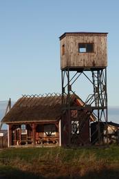
Estland
Putnu verosanas tornis Puises ragaPuises ragā (Puise nina) ir uzcelts divstāvīgs atpūtas nams, kas apvienots ar putnu vērošanas torni. No tā paveras skats uz piekrasti, kas ir iecienīta migrējošo zosu atpūtas vieta. Šī ir privāta teritorija, kuras apskati vēlams saskaņot ar īpašnieku. 123
Leistungen
123km - Entfernung von der Hauptstadt |
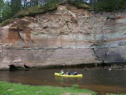 |
Estland
Fluss AhjaEiner der schönsten Flüsse im Südestland mit Sandsteinfelsen aus dem Devon und Höhlen. Der 22 m hohe Große Taevaskoja Felsen. |
 |
Estland
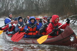
360° AbenteuerAngebote zum Natururlaub: Seekajakwanderungen im Sommer, Schneesschuhwanderungen im Moor im Herbst und im Winter, Kanuwanderungen auf Flüssen im Frühjahr 37
 1-12 1-12
Leistungen
37km - Entfernung von der Hauptstadt
1-12 Aktive Saisonmonate |
 |
Estland
Naturschutz-gebiet ViidumäeWurde für den Schutz der seltenen Pflanzenarten (auch endemische) und Biotopen an der alten Uferlinie vom Ancilus See gegründet. Leistungen
244km - Entfernung von der HauptstadtLeistungen - erholung
NaturpfadThe Viidumäe educational trail (1.2 km), the Audaku hiking trial (2.8 km).
NaturbeobachtungThere is a viewing tower on Mount Viidumägi with a broad view of the western end of the Saaremaa Island. It’s worth visiting the visitor centre at Audaku. |
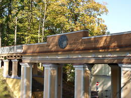 |
Estland
Domberg TartuVom 19. Jh. ist der Domberg ein offentlicher Park mit Pfaden, Gehwegen, Brücken (Engelsbrücke, Teufelsbrücke) und den Denkmälern für die Wissenschaftler der Tartu Universität. Hier befinden sich die Domkirche, das Anatomicum, das Observatorium u.a. interessante Objekte. 185
Leistungen
185km - Entfernung von der Hauptstadt |
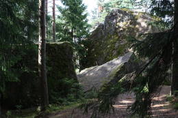 |
Estland
Stein TammispeaDie Größe dieses Feldsteins ist eindrucksvoll, obwohl er nach dem Volumen (262 m3) nur der 16. größte Feldstein Estlands ist. Die Länge beträgt 10,7 m, Breite – 6,5 m, Umfang – 27,8 m. 70
Leistungen
70km - Entfernung von der Hauptstadt |
 |
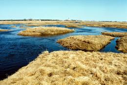
Estland
Penije tornis (Penijõe torn)Lai nokļūtu līdz šim tornim, ir jāveic apmēram 20 – 30 min ilgs pārgājiens pa dabas taku no Penijē muižas gar Penijegi (Penijõgi) kreiso krastu. Te redzami bebru darbi un to celtās zaru mājas. No torņa paveras skats uz Kazari deltu, kas dabā izpaužas kā monolīts un nepārskatāms niedrājs. To vairākās daļās sadala Kazari un mazāka izmēra upītes. Katrai deltas daļai ir savs vēsturiskais nosaukums: no torņa pa kreisi no Penijegi redzama Lihula meri (Lihulas „jūra”), bet tās labajā pusē - Kloostri meri (Klostri „jūra”). Putnu vērotāji var iziet garāku (7 km) dabas takas loku, kas ved pa palieņu pļavām. Jārēķinās, ka pavasaros būs nepieciešami piemēroti apavi! Pļavas ierobežotās platībās apsaimnieko mājdzīvnieki, tādēļ neaizmirstiet aizvērt vārtiņus aiz sevis un netraucējiet to ikdienas gaitas! No maršruta nav atļauts novirzīties, lai netraucētu putnus. |
 |
Estland
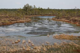
Klostri (Kloostri) skatu tornisMetāla tornis Kazari upes kreisajā krastā, ~ 5 km attālumā no Matsalu līča. No torņa redzamās Kazari deltas palieņu pļavas atrodas tikai 0,3 – 1 m augstumā virs jūras līmeņa, tādēļ pavasara palos un stipru vētru (īpaši rietumvēju) laikā ūdens appludina milzīgu teritoriju. Uzskata, ka platības ziņā šīs ir vienas no lielākajām Eiropas palieņu pļavām, kas ir nozīmīga dažādu tārtiņveidīgo putnu sugu ligzdošanas, dzērvju un zosveidīgo putnu atpūtas un barošanās vieta. Ir pagājis laiks, kad zemnieki Matsalu pļavās ganīja govis un pļāva sienu, tādēļ šobrīd pļavu apsaimniekošanu veic nacionālā parka administrācija. |
 |
Estland
Ehijervs (Ähijärv)Karulas nacionālā parka lielākais ezers - 2,8 km garš, līdz 1 km plats. Ezera ziemeļaustrumu krastā atrodas parka apmeklētāju centrs. 5,5 m dziļais ezers ir gan zivīm, gan nostāstiem bagāta vieta. Ezera un tuvākās apkārtnes iepazīšanas nolūkā ir izveidota 3,5 km garā Ehijerva taka (Ähijärve teerada). Tās sākums atrodas pie iepriekš minētā apmeklētāju centra, kur izveidota atpūtas vieta un atraktīvs bērnu spēļu laukums. Taka sākumā ved gar ezera krastu, nelieliem mitrājiem un meža ceļiem, kas izmantoti iepriekšējos gadsimtos. |
 |
Estland
Kulturerbe-Fahrradroute von KoivaSeit Herbst 2010 gibt es am Fluss Koiva (Grenzfluss zwischen Estland und Lettland) eine 60 km lange Fahrradroute, die Kulturerbeobjekte beider Staaten präsentiert. Die Route beginnt im Parkplatz am Berg Tellingumäe parklast, an den beiden Enden und am Grenzübergang sind Rastplätze und Karten. Wegweiser auf den Kreuzungen zur Navigation vorhanden, ausserdem sind die Sehenswürdigkeiten etwas abseits leicht zu finden. Beschreibungen bei den Objekten sind auf Estnisch, Lettisch und Englisch. Im Startpunkt beginnt auch eine andere 18 km lange Route. 267
1-12
Leistungen
267km - Entfernung von der Hauptstadt
1-12 Aktive Saisonmonate |
 |
Estland
Halbinsel KäsmuEine von Nadelbaumwäldern bedeckte Halbinsel. Malerisches Käsmu Steinfeld, Matsikivi Stein, Vana Jüri Stein u.a. Bei passenden Bedingungen kann man sich auf einer steinernen Landzunge bis zur 0,5 km entfernt liegenden Insel Saartneem schleppen. 81
Leistungen
81km - Entfernung von der Hauptstadt |
 |
Estland
Nationalpark VilsandiWurde für den Schutz der Inselgruppe Vilsandi (ung. 100 kleine Inseln) gegründet. Die größte ist 6 km lange un bis 2 km breite Vilsandi Insel. Leistungen
255km - Entfernung von der HauptstadtLeistungen - erholung
Fahrten mit Schiff/BootBoat along the islands of the archipelago, but keep in mind that the Vaika Island and the Nootamaa Island are nature reserves which are closed to visitors.
NaturpfadHike the route Loona-Kuusnõmme (8 km), hike around the Vilsandi Island (~12-15 km), hike the Harilaid peninsula (~10 km).
NaturbeobachtungBird-watching from the southern end of the Vilssandi Island – the nearby Vaika Island is closed to visitors. There is a viewing tower on the N end of the Kuusnõmme peninsula. The visitor centre of the park is found at the Loona estate (Loona mõis). |
 |
Estland
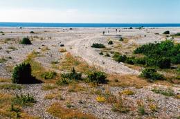
OsmussaarThis is a “peripheral” island in the Bay of Finland, 9 km from the Dirhami port. The special fact about this island is that it offers fields of juniper, a rocky and grassy seashore that is around 2 km long, and limestone cliffs that are a few metres high along the northern and the eastern shores of the island. These are designated with the words Osmussaare pank.
|
 |
Estland
WikingerdorfEinzigartiger Themenpark am Fluss Pirita, wo sich alles um die alten Wikinger dreht. Leistungen: Wikingerburg, Zauberstube, Schmiede, prähistorische Kampfspiele, Schauspiele, Abenteuerreisen mit Wikingerboot auf dem Fluss Pirita, Wanderungen mit Einbaumboot, Wurfwaffen, Bogenschiessen, Axtwerfen, Höhlensauna, Rauchsauna, Forellenfang, Erlebnisunterkunft, Verpflegung u.a.  30
1-12
30
1-12
Leistungen
30km - Entfernung von der Hauptstadt
1-12 Aktive Saisonmonate |
 |
Estland
Insel PiirissaareInsel Piirissaare im Peipussee hat eine Fläche von 7,5 km². Die Inselbewohner sind grossenteils ussische Altgläubige. Die alte Kultur ist während Jahrhunderten gut erhalten geblieben. Die Hauptbeschäftigung der Inselbewohner ist Fischfang. Auf den Feldern wird Gemüse, hauptsächlich Zwiebel angebaut. 262
1-12
Leistungen
262km - Entfernung von der Hauptstadt
1-12 Aktive Saisonmonate |
 |
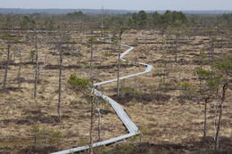
Estland
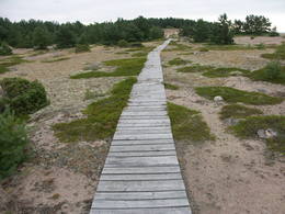
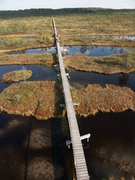
Risas purva taka (Riisa rabarada)Izcila lokveida taka (4,5 km), kuras lielākā daļa (koka laipas) ved pa Rīsas purvu (Riisa raba). No takas un divstāvīgā koka skatu torņa ir vērojami purva ezeriņi, lāmas, un purvaini meži. Ja nacionālā parka apskati sāk no ziemeļu puses, tad šī taka ir labs ceļojuma iesākums! |
 |
Estland
Rannaje putnu verosanas tornis (Rannajõe linnutorn)Divstāvīgs skatu tornis pie Laikjula (Laiküla) – Hāpsalu ceļa, no kuras paveras plaša ainava uz Matsalu līcī ietekošo upīšu palieņu pļavām. Te var vērot migrējošās dzērves un zosis, bet pavasaros varbūt laimēsies redzēt vai dzirdēt ķikutu Gallinago media. Viens no retajiem torņiem, kas ir pielāgots cilvēkiem ar īpašām vajadzībām. |
 |
Estland
Kuranidu macibu taka (Kuuraniidu õpperada)1,7 km gara lokveida taka, kas iepazīstina ar dažādiem meža biotopiem, to iemītniekiem un meža apsaimniekošanas pamatprincipiem. Apmeklētāju ērtības nolūkā ir izveidotas koka laipas un neliels skatu tornis. 159
Leistungen
159km - Entfernung von der Hauptstadt |
 |
Estland
Familienpark der Waldweisen (Metsamoori perepark)Der Familienpark der Waldweisen in der Hugellandschaft Kaika ist ein Netzwerk von Bauernhöfen und bietet verschiedene Möglichkeiten an, um sich mit gesunden Lebensweisen und der Volksmedizin vertraut zu machen. In den Programmen kann man die Pflanzen- und Blutegelbehandlung, die Zauberreiche von Bienen und Pilzen kennen lernen sowie den Einfluss von Zauberworten und Meditationsorten erleben. Zubereitung von Speisen aus Unkraut, von Hausbrot und Kräuterheilmitteln. 275
5-9
Leistungen
275km - Entfernung von der Hauptstadt
5-9 Aktive Saisonmonate |
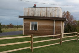 |
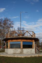
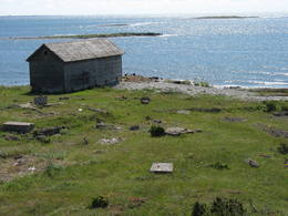
Estland
Skatu platforma Puises ciemaPuises „centrā” uz vienstāvu koka mājiņas jumta izveidota skatu platforma. No tās paveras laba ainava uz ciemu, ostu un piekrastes kadiķu laukiem. 121
Leistungen
121km - Entfernung von der Hauptstadt |


