
| No | Name | Description |
|---|---|---|
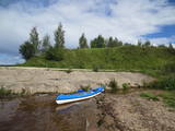 |
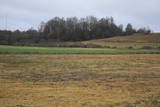
This is an ancient and important place for trade and craftsmanship on the left shore of the Rīga hydroelectric power plant reservoir. It rises some 15 m above the Daugava River. The Zemgale port that is described in historical documents is thought to have been located alongside the castle hill and at the mouth of the little Varžupīte stream. Antiquities that have been dug up here suggest that the castle hill and its adjoining ancient settlement were populated until the late 12th century, when the importance of Daugmale began to shrink because of rapidly growing Rīga. The foundations of the castle hill have been shored up. |
|
 |
Atrodas Tērvetē, Dobeles – Elejas ceļa malā, 0,2 km dienvidrietumos no Tērvetes pilskalna. Ar mežu apaugušais paugurs ir sena apmetnes vieta, kas bijusi apdzīvota jau 1. g.t. pr. Kr. Teika stāsta, ka kalnā bijis klosteris, kura mūki pēc klusēšanas pārkāpuma saulgriežu laikā kopā ar visu celtni nogrimuši kalna dzīlēs. |
|
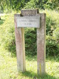 |
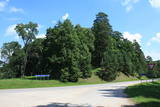
Marking of the Jānis Lībietis Alley in the
Ķemeri Park – Lībietis directed the institution
which managed the Ķemeri sulphurous springs
from 1928 until 1944, and the monument to
him is at the end of the Jānis Lībietis Pathway
|
|
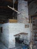 |
In Metsanurme Village Centre you can see restored old threshing barn, limestone barn oven and few tools that were used ages ago. You could be also interested in seeing an outdoor exhibition which focuses on historical agricultural tools. All of this is made to look interesting to not only locals but also visitors. |
|
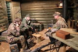 |
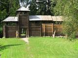
Pie Vidzemes šosejas pirms Melturu tilta pāri Amatai ir privātais muzejs "Mežabrāļu bunkurs". Bunkurs izveidots, lai varētu vēstīt par Nacionālo partizānu mežabrāļu cīņu laikā no 1944.-1956. gadam, kad mežos pret okupācijas varu cīnījās ap 20 000 Latvijas patriotu. Nacionālo partizānu bunkurs izveidots balstoties uz savāktajām mežabrāļu atmiņām, dienasgrāmatu pierakstiem un fotogrāfijām. Uz bunkuru ved meža taka ar informāciju par dažādiem mežabrāļu piedzīvojumiem un cīņām. Bunkura pazemes daļā apskatāmi vēsturiskie priekšmeti, kas viņus pavadīja dzīvē un cīņā. Saimnieks piedāvā pastaigu pa meža taku, kur izvietota informācija par mežabrāļiem un slēpņu spēle bērniem. Ar iepriekšēju pieteikšanos iespējams iekļūt bunkurā un apskatīt iekārtotu bunkuru ar mežabrāļu izmantoto ieroču, munīcijas un citu priekšmetu ekspozīciju. Stāstījumu papildina savāktās mežabrāļu interviju videoieraksti. Apmeklētājiem iespējams pasūtīt mednieku desiņu cepšanu lapenē pie bunkura. |
|
 |
Neliela apdzīvota un ainaviska vieta plašajā Skrobļa (Skroblus) strauta ielejā. Ciema austrumu pusē atrodas Lietuvas mērogā unikāls objekts – klēts - rija, kur no 1929. g. vietējie cilvēki uzveda un skatījās lauku teātra izrādes. Netālu no tās (uz abiem objektiem ir norādes) atrodas Skrobļa avoti (Skroblaus versmės), kas iztek no dziļas starppauguru ieplakas. Avotu gan ir appludinājis bebru uzceltais dambis. Dienvidos no ciema atrodas vecs grants karjers, kas ir viena no retajām vietām Baltijā, kur dabā ir atrodami krama ieža gabali, kas atnesti ar ledāju. |
|
 |
Grūti iedomāties, ka vēl joprojām Eiropā ir apdzīvotas vietas, kuru sasniegšanai ir labu laika sprīdi jābrauc pa neapdzīvotu mežu ieskautu smilšainu ceļu, kur tikai paretam var redzēt kādu sēņotāju vai ogotāju! Tāpat kā Zervinos ciemam, arī šim ir piešķirts kultūras mantojuma pieminekļa statuss, jo Linežeris ir viens no dažiem nacionālā parka etnogrāfiskajiem ciemiem. Linežerī ir aplūkojamas 19. – 20. gs. mijā celtās ēkas un apskatāms tā laika ciema plānojums. Šejieniešu tāpat kā citu dzūku galvenā nodarbošanās bija mežistrāde un meža velšu vākšana. Nelielā mērā – arī lauksaimniecība. Apceļojot nacionālā parka etnogrāfiskos ciemus, rodas pamatots jautājums: „Ar ko mūsdienās te nodarbojas cilvēki. Kā viņi spēj dzīvot tik nomaļā vietā”? Jāatzīst, ka lielākā daļa te ierodas tikai vasaras laikā. Neskatoties uz to, etnogrāfiskie ciemi ir ļoti sakopti un joprojām „dzīvi”! |
|
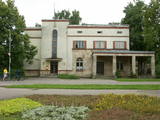 |
The building was erected during the first period of Latvian independence, and it maintained its functions for a long time. The building is located at Tukuma Street 30. Beginning in 1940, the post office had an automated telephone central. The Postal Service no longer uses it, and the building can only be viewed from the outside. |
|
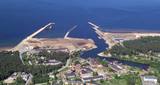 |
In the 19th century at the seaside of Skulte, a small village formed, which was inhabited by fishermen. The name “Zvejniekciems” (Fishermen’s village) arose from the population's main activity. In 1967 the Skulte part of Zvejniekciems was added to the Saulkrasti township. Nowadays Zvejniekciems is the home of Skulte Port, and the rocky beach of Zvejniekciems is located between the port and Saulkrasti Beach, while the village itself can be proud of the creative heritage left by the architect Marta Staņa (1913–1972). |
|
 |
A haven for Russian Old Believers. Mustvee village has held fairs for the past two centuries. It is also a traditional fishing town. |
|
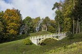 |
Temple Hill is steep (with artificially created steepness) and about 30 m high, and it is opposite Marijas Island. It is an ancient Lettigalian castle hill, 80 m long and 40 m wide, with several artificial ramparts. One of the oldest objects found in the region is an axe from the 2nd to 3rd millennium BC. Archaeologists believe that the island was populated at that time. There was a Lettigalian castle on the hill during the 10th and 11th century, but it was sacked by the Holy Crusade. The surface of the castle hill was transformed comparatively recently in 1807, when a granite rotunda was built there in honour of Russian Field Marshall Sheremetev and Swedish captain Wulff. The view of Lake Alūksne and the town is one of the most beautiful ones in all Vidzeme. The Sun Bridge (1937) is also worth a look. A wooden viewing platform is nearby. |
|
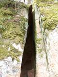 |
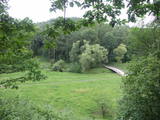
The Vējupīte ravine is meant for those who are not afraid of long and steep wooden stairs of the type that lead you up and down the ravine. From the Līvkalns guesthouse, you can climb the stairs downward, where you will find a shallow (3.6 m) but high (6.1 m) cave – the Pēters Cave. It is something of a gap or a niche. Another 10 minutes or so downstream (toward the Gauja) will lead you to the deep Pūces ravine and its Kraukļupīte River. The Satezele castle hill is at the confluence of the two rivers (90 x 75 m). A wooden castle was there during the feudal era in the early 13th century. Its main entrance was on the western side of the castle hill. You can get to the hill from the depths of the ravine via a wooden staircase. The Kraukļi ravine, in turn, is accessible if you climb down the same stairs and continue on your way toward the Gauja. The ravine is found on the left bank of the Vējupīte, and its sandstone walls are up to 11 m high. The Kraukļi cave, which is 5.2 m deep, is on the wall. Another 10-15 minutes (crossing the Vējupīte on a wooden bridge), and you will find another staircase leading you to Paradīze Hill (see the description above). |
|
 |
Atrodas Vārtājas ielejas labajā krastā un labi saskatāms no Priekules – Grobiņas (P106) ceļa. Senās kuršu zemes – Piemares pilskalns, kas vēstures avotos pirmo reizi minēts 1253. gadā – līgumā starp Kurzemes bīskapu un Livonijas ordeni. Viens no lielākajiem Dienvidkurzemes pilskalniem. Iespējams, ka iepriekš – arī sens kulta kalns. Pagājušā gadsimta sešdesmitajos gados veiktajos arheoloģiskajos izrakumos konstatēts, ka pilskalns bijis apdzīvots jau vidējā dzelzs laikmetā. Pie tā konstatēta liela senspilsētas vieta. |
|
 |
Svētkalnā atradusies krustnešu nocietinātā pils. Zemgaļiem to nebija pa spēkam ieņemt, tādēļ, nodedzinādami savu pili Tērvetes pilskalnā (1286. g.), tie aizgāja uz Raktes (Žagares) novadu Lietuvā. Kad Svētkalna nocietinājumi bija zaudējusi savu militāro nozīmi, krustneši to nojauca. 1701. g. Ziemeļu kara laikā Svētkalnā atradās zviedru armijas nocietinātā apmetne, no kā arī cēlies vietvārds. Domājams, ka pirms tam šajā vietā atradusies seno zemgaļu svētvieta. No Svētkalna paveras viena no skaistākajām un biežāk fotografētajām Tērvetes ainavām. |
|
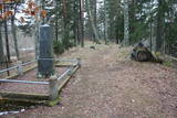 |
The Middle Ages and the beginning of the last century cemetery at the church of Mazirbe. It is surrounded by a moss-covered stone fence. There you can find a number of interesting sights-Werewolf's Tomb, Old Taizelis Tomb, Grand Pine, etc.. |
|
 |
Находится на ул. Базницас, д. 17. Здание построено в XVII веке, как жилой дом кулдигского бургомистра. В 1701 году здесь гостил король Швеции Карл XII, который в передней оставил огромный сундук (2 х 2,5 м), на который после реставрации можно взглянуть и сегодня. |
|
 |
Kassinurme hills were formed during the last Ice Age, and an ancient stronghold and a sacred grove can be found in the hills. At the foot of the stronghold a stage has been built; a swing, tepees, a campfire place and a model of the stronghold are located in the forecourt. Nature, health and antiquities trails are located nearby. |
|
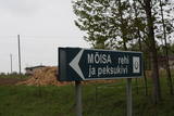 |
Neliela apdzīvota vieta nacionālā parka ziemeļrietumu daļā, kur kādreiz atradusies Rebases muiža. Mūsdienās no tās saglabājušās klēts atliekas, pie kurām apskatāms interesants vēstures liecinieks – sens akmens, ko izmantoja kulšanas procesā (Peksukivi). |
|
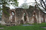 |
Lullemē atrodas blakus parka robežai, bet arī šo vietu ir vērts pieminēt kā vienu no apskates objektiem. Lullemē uzmanību piesaista viena otrai blakus stāvošās baznīcas. Mūsdienās redzamās 15. gs. celtās Sv. Marijas baznīcas drupas ir liecinieks 2. pasaules kara notikumiem, kad 1944. g. baznīcu sagrāva. Jaunā baznīca ir celta 1997. gadā. Ciema rietumdaļā uzstādīts piemineklis, kas veltīts brīvības cīņās (1919. – 1920.) kritušajiem. |
|
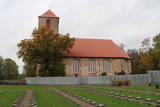 |
The graveyard that is alongside the Lestene Lutheran Church is the final resting place for more than 900 soldiers who fell during World War II, particularly during battles at the so-called Fortress of Kurzeme, as well as in Zemgale and Vidzeme. The sculptress Arta Dumpe designed the commemorative monument “Mother Motherland – Latvia.” The cemetery of the brethren is the second largest resting place for soldiers from World War II after the Cemetery of the Brethren in Rīga. The names of some 11,000 soldiers are engraved on the gravestones. |
|
