
| No | Name | Description |
|---|---|---|
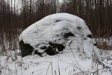 |
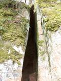
The historic stone, on which there is carved over 200 years old boundary-mark, sets the border between the Duchy of Courland and the Russian province. Nowadays, it sets the Babīte and Jelgava district boundary. The stone lies to the East of Kalnciems–Peat road (the south of the swamp Labais purvs) at the edge of a forest firebreak and it can be hard to find. To this end, the description of the road map may help: around 400 m south of the car parking lot at Lily Lake from Kalnciems-Peat road to the right (in the east) turns a forest road which leads down from hills Krāču kalni. It should be around 170 m to go until it abruptly turns to the right (to the southeast). Then you must go in this direction until after ~ 0.5 km to turn to the northeast where after further ~ 0.4 km of the current forest road intersection turn to the north. After ~ 0.4 km turn right (to the east) on a big firebreak, on the left (the north) side of which behind the drainage ditch during the non-leaf period there can be seen a rounded stone. Due to the poor condition of roads, the stone can be reached only on foot. |
|
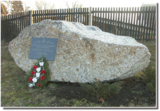 |
The memorial stone to Augusts Muižulis,a recipient of the Lāčplēsis Military Order, is placed in the Lapmežciems, at the edge of the road (P 128, Jūrmala-Talsi) at the marker for the 9th kilometre. A. Muižulis, (189 –1941) was a lieutenant colonel in the No. 4 Valmiera Infantry Brigade. The adjacent Tuteņi homestead is his native home. |
|
 |
Musteikas pirmsākumi ir meklējami jau 18. gs. Līdz Musteikai no Marcinkones puses var nokļūt pa grantētu ceļu, kas ved gar bijušajiem kolhoza zivju dīķiem. Automašīnu var atstāt ciema sākumā un izstaigāt to ar kājām, izjūtot veco ēku smaržu un šarmu. Musteikā atrodas Dzūkijas biškopības vēsturei veltīts „dzīvs” muzejs, kur stropos dzīvo bites, bet tā saimnieks ir biškopis pēc aicinājuma un būtības. Ja palūgsiet, viņš demonstrēs – kā ar krama, metāla un posas piepes palīdzību senos laikos ieguva uguni. |
|
 |
Located on the left bank of the Venta River 100 m to the Northwest of the Liepāja (A9) highway bridge across the river. The antique castle hill was the site of a Livonian Order that existed from the 14th to the 18th century before being sacked during the Great Northern War. No part of the castle has survived. A stage was built on the castle hill in 1987, and it is a popular venue for various events. The hill is surrounded by a park with wooden chairs that were designed by the sculptor Ģirts Burvis in honour of the kings of Courland. There is a viewing platform, and there are legends about underground passages and a white lady who appears only once every 100 years. |
|
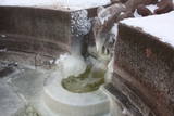 |
Built in the turn of the19th to 20th century. Next to it-on the right bank of the river Vēršupīte, there is located one of the most popular Latvian sulphur water springs, called "Small lizard". The spring runs out from a stone-designed lizard sculptured in 1949 (Sculptor J. Bajārs). Its water is healthy for using both internally and externally. Not far from the pavilion there can be found Jānis Lībietis alley sign. J. Lībietis worked in the position of a director for the sulphur water spring authority of Kemeri from 1928 to 1944. |
|
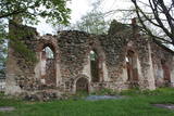 |
Lullemē atrodas blakus parka robežai, bet arī šo vietu ir vērts pieminēt kā vienu no apskates objektiem. Lullemē uzmanību piesaista viena otrai blakus stāvošās baznīcas. Mūsdienās redzamās 15. gs. celtās Sv. Marijas baznīcas drupas ir liecinieks 2. pasaules kara notikumiem, kad 1944. g. baznīcu sagrāva. Jaunā baznīca ir celta 1997. gadā. Ciema rietumdaļā uzstādīts piemineklis, kas veltīts brīvības cīņās (1919. – 1920.) kritušajiem. |
|
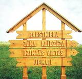 |
„Upmaļi” is the family house of writer Janis Klīdzējs who has written 8 novels, 11 storybooks, 2 essay books
and reflections about Latgalian catholic-Latvian mentality. Janis Streičs (famous Latvian film director) shot a film
based on the novel of Janis Klīdzējs called „The Child of a Man”.
|
|
 |
Kassinurme hills were formed during the last Ice Age, and an ancient stronghold and a sacred grove can be found in the hills. At the foot of the stronghold a stage has been built; a swing, tepees, a campfire place and a model of the stronghold are located in the forecourt. Nature, health and antiquities trails are located nearby. |
|
 |
Das alte zemgalicshe wirtschaftspolitische Zentrum, das eine stark befestigte Siedlung vor der Ankunft der Kreuzritter war. Die Ruinen der Burg des Livländischen Ordens. |
|
 |
The Narūta River which flows out of Lake Ežezers is approximately 1 km long and ends at the small Obiteļi windmill lake. On the right bank of the river is a windmill that was built around 1900. Today the site has the Obiteļa leisure centre with a sauna and banquet facilities. |
|
 |
Taisnā Celtnieku iela ir bijušās Liepājas – Aizputes šaursliežu dzelzceļa (celta 1900. gadā, 49 km gara) līnijas „trase”, kuras malā (Celtnieku ielā 50) redzama bijusī dzelzceļa stacijas ēka. |
|
 |
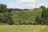
This partly forested hillock stands 40 metres above the surrounding area and offers impressive views. The fact that this was once a castle hill is attested by the presence of a moat and remnants of defensive fortifications. It is thought that Lettigalian tribes settled here in the 10th century AD. You can climb the hillock to take a look at the surrounding landscapes. |
|
 |
The Vējupīte ravine is meant for those who are not afraid of long and steep wooden stairs of the type that lead you up and down the ravine. From the Līvkalns guesthouse, you can climb the stairs downward, where you will find a shallow (3.6 m) but high (6.1 m) cave – the Pēters Cave. It is something of a gap or a niche. Another 10 minutes or so downstream (toward the Gauja) will lead you to the deep Pūces ravine and its Kraukļupīte River. The Satezele castle hill is at the confluence of the two rivers (90 x 75 m). A wooden castle was there during the feudal era in the early 13th century. Its main entrance was on the western side of the castle hill. You can get to the hill from the depths of the ravine via a wooden staircase. The Kraukļi ravine, in turn, is accessible if you climb down the same stairs and continue on your way toward the Gauja. The ravine is found on the left bank of the Vējupīte, and its sandstone walls are up to 11 m high. The Kraukļi cave, which is 5.2 m deep, is on the wall. Another 10-15 minutes (crossing the Vējupīte on a wooden bridge), and you will find another staircase leading you to Paradīze Hill (see the description above). |
|
 |
Beliebte und eine der ältesten Straßen in Jurmala zwischen Dzintari und Majori. Die 1,1 km lange Straße mit Wirtshäusern, Sommercafés und Souvenirladen. |
|
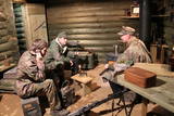 |
Pie Vidzemes šosejas pirms Melturu tilta pāri Amatai ir privātais muzejs "Mežabrāļu bunkurs". Bunkurs izveidots, lai varētu vēstīt par Nacionālo partizānu mežabrāļu cīņu laikā no 1944.-1956. gadam, kad mežos pret okupācijas varu cīnījās ap 20 000 Latvijas patriotu. Nacionālo partizānu bunkurs izveidots balstoties uz savāktajām mežabrāļu atmiņām, dienasgrāmatu pierakstiem un fotogrāfijām. Uz bunkuru ved meža taka ar informāciju par dažādiem mežabrāļu piedzīvojumiem un cīņām. Bunkura pazemes daļā apskatāmi vēsturiskie priekšmeti, kas viņus pavadīja dzīvē un cīņā. Saimnieks piedāvā pastaigu pa meža taku, kur izvietota informācija par mežabrāļiem un slēpņu spēle bērniem. Ar iepriekšēju pieteikšanos iespējams iekļūt bunkurā un apskatīt iekārtotu bunkuru ar mežabrāļu izmantoto ieroču, munīcijas un citu priekšmetu ekspozīciju. Stāstījumu papildina savāktās mežabrāļu interviju videoieraksti. Apmeklētājiem iespējams pasūtīt mednieku desiņu cepšanu lapenē pie bunkura. |
|
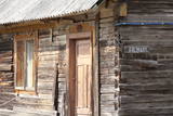 |
Vāldamõ – a residential building that is yellow and has natural roofing materials. It was built as a new farm at the beginning of the last century. Virgo is the next homestead to the North from Vāldamõ, and it was established as a new farm in the 1920s. The house (1930) features interesting wood carvings. Next to the North is Fīlmaņi, which has a building that appears antique, but was built in the early 20th century as a single roof. Silkalni is the homestead that we find if we turn to the right toward Pitrags at the crossroads. The yellow building was built around 1906 as a single room. Norpiedagi is to the South from Silkalni – a brown and larger house than the previous one. The home was built around 1906 as a one-room granary by the active Liv public activist and boat builder Diriķis Volganskis (1884-1968). His son, Edgars Valgamā, who was also a Liv cultural activist and worked as a pastor in Finland, was born here. Anduļi can be found at the aforementioned crossroads. This is one of the largest old farms in the village, and it is owned by the village elder. The history of the homestead was first recorded in 1680, when it was called Kūkiņi. The homestead includes a residential building (c. 1909), a threshing barn (1905), a granary (mid-19th century), and a smokehouse made of a boat that was cut in two. Under the part of the threshing barn which is on the back of the dune, there is the medieval, so-called Plague cemetery. Žoki is a homestead that is on the other side of the road from Anduļi. The building that is there now was built on the foundation of an older one. In the mid-19th century, Žoki was home to the first reading school for Liv children from the seashore villages of the Dundaga region. Liv Nika Polmanis (1823-1903) worked there as a teacher. Next to the North of Žoki is the Tilmači homestead, with several buildings that were built in the late 19th and early 20th century – a brown residential building, a stable and part of a granary. When the residential building was restored, the owner found a board reading "1825. Kurlyandskaya gubernya." The seven historical homesteads and buildings were at one time considered for listing on the UNESCO list of world heritage. |
|
 |
To the East of the Ezermuiža-Dūmele road you will find the bed of the ancient Lake Dieviņezers. It was one of the largest lakes in Kurzeme in the past, being 7.5 km long and 1.6 km wide. A canal was dug in 1838 (Melnsilupe River today), and the water from the lake was siphoned to the sea so as to create fertile farmland. Residents of Ezermuiža have been involved in forestry work since the age when barons ruled the land. Dūmele is connected to Košrags by a lonely forest road that is known as the Bottom Road. A bike route runs down it. The Ziedkalni weekend house is in Dūmele. The "Ziedkalni" homestead in Dūmele offers spa services, cod fishing and accommodations. |
|
 |
Old Believers, who fled persecution from the Russian Orthodox church because of their refusal to adapt to church reforms, settled down on the western shore of Lake Peipsi in the 17th and 18th centuries. |
|
 |
Atrodas 0,3 km ziemeļos no Vecpiebalgas pilsdrupām. Ap 10 m augsto, bet visnotaļ izteiksmīgo Grišku kalnu sauc arī par Piebalgas, Balgas un Veļķu pilskalnu. 13. gs. šeit bijusi svarīga apmetnes vieta ar mākslīgi nostāvinātām nogāzēm un dziļu aizsarggrāvi. Vēstures notikumi ir atstājuši ap metru biezu kultūrslāni. Bezlapu laikā no kalna paveras skats uz Vecpiebalgas baznīcu un pilsdrupu vietu. Pilskalna piekājē ir aka ar Griškavotu. |
|
 |
One of the most interesting objects in Bigauņciems, the road begins at the seashore, crosses the Vecslocene River (there is no bridge, but hikers and bikers can get across it), and then continues as a forest road to Lake Melnezers. |
|
