
| No | Name | Description |
|---|---|---|
 |
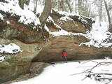
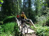
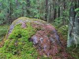
Atrodas mežā, netālu no Kaltenes. Labiekārtota (laipas, kāpnes, informācijas stendi) taka, kas iepazīstina ar Latvijai samērā neparastu dabas pieminekli (aizsargājams) – Kaltenes kalvām, kas ir lieli, līdztekus Rīgas jūras līča krasta līnijai orientēti laukakmeņu krāvumi. Uzskata, ka tos veidojuši Baltijas ledus ezera ūdeņi un ledi. Garums – ap 1,5 km. |
|
 |
The Kaļķupe River valley was established as the Pilsupe River (formed by Kaļķupe River and Mazupe River) crossed the Blue hills of Šlītere to the South of Vīdale and Kaļķi. The distinct river valley has a branched network of gullies in which Devonian sandstone has been uncovered and can be seen in some locations. Puiškalns Hill (located at confluence of Kaļķupe River and Mazupe River), which was used as a castle hill and as a sacred location long in the past, is one of the most distinctive parts of the area. It is a popular tourist destination in the Talsi District. Hillside forests, various kinds of meadows and a wide range of plants are also of value in the local environment. |
|
 |
This 368 metre structure is the highest television tower in the European Union. Its viewing area, which is at a height of 97 metres, is the highest publicly available viewing area in Latvia. The location offers a fantastic view of Rīga and Old Rīga to Pārdaugava, the Bay of Rīga and Sigulda – a radius of at least 50 kilometres.
|
|
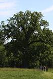 |
The tree is on the side of a hillock, and its visible roots are unusually huge.
|
|
 |
The Neļķes cliffs are in Skaņākalns Park, and they offer the most beautiful view of the Salaka River valley, with its sandstone cliffs and peaceful river. There are good views from the “devil’s pulpit.” It’s worth visiting the Skaņamkalns Hill to check out the views from the famous echo cliff. This is part of the ZBR.
|
|
 |
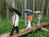
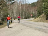
Maršruts "Murjāņi - Līgatne" ved caur Gaujas senieleju ar devona smilšakmens atsegumiem, raksturīgo augu valsti un dzīvniekiem. Krastos sastopami Latvijā lielākie nogāžu un gravu meži ar liepām, ozoliem, gobām un ošiem. Upes līkumos palienē aug baltalkšņu un vīksnu audzes. Uz koku stumbriem atrodams plaušķērpis. Senieleja bagāta ar sausokņiem un kritalām, tāpēc Gaujas krastu mežos dzīvo visu Latvijā sastopamo dzeņu dzimtas sugu putni. Smilšainajās Gaujmalas pļavās un Gaujas vecupēs ir bagātīga bezmugurkaulnieku fauna. Upes krastos ir smilšakmens klintis ar čurkstu alām un zivju dzenīša ligzdām. Klinšu pakājē iztek avoti, kas uztur mikroklimatu ielejā. Gauja ir nozīmīga arī kā Latvijas lielākā lašupe. Maršruts ir daļēji marķēts un papildināts ar norādēm un informācijas stendiem. |
|
 |
The tower is at the western end of the Seda swamp, accessed from the side of Jērcēni. Transport is limited here. The tower is in the area of the swamp where peat moss is extracted. It offers a broad view of the ponds of Seda and a boat rental facility that is nearby. It is an appropriate location for bird-watching during the season of migration. There is another bird-watching platform near the town of Seda. This is part of the ZBR. |
|
 |
This territory is to the North of Skrunda, and it is an important location for water birds during their migration. Northern swans nest in the ponds, and sea eagles and other birds such as falcons and plovers use them for feeding. This is a good place for bird-watching, although it has not been particularly structured for that purpose. |
|
 |
Dabas liegums veidots ezera, tā salu, ainavas, augu, putnu un sikspārņu aizsardzībai. Liegumu var apskatīt "no malas" - no ceļa, kas iet gar tā ziemeļu un ziemeļaustrumu robežu.
|
|
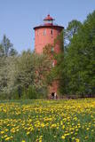 |
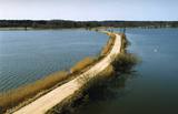
is the second oldest navigation structure in Latvia and the only one that is five kilometres from the shore, at the upper edge of the ancient Lake Baltic Ice. Since 2000 the lighthouse has not served its initial purpose, and now it is the home to the Nature Education Centre "Slītere" of the Slītere National Park. The centre offers exhibitions about lighthouses in Latvia and the history of the Baltic Sea. From the upper floor (102 m above sea level) one can see the coast of Saaremaa (approximately 33 km away). Alongside the lighthouse is the 1.2 km Šlītere nature trail. |
|
 |
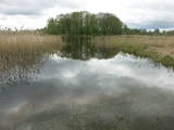
Kaņieris is a seriously overgrown and
shallow seaside lake. Its water level was
adjusted several times during the 20th
century so as to obtain agricultural lands.
The lake has 14 islands, among which nine
are natural and the rest are artificial and
aimed at attracting nesting water birds.
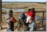
Lake Kaņieris has one of the richest
diversities of birds in Latvia. An
ornithological nature reserve was
established here in 1964. In 1989, the lake
was placed on the list of major birding
locations in Europe, and in 1995 it was put
on the list of the Ramsar Convention. At
the southeastern shore of the lake is a
boating facility (only rented boats are
permitted on the lake). A bird-watching
tower was erected on the Riekstu
peninsula in 2009
|
|
 |
This trail of pathways dates back to 2005 and it passes from the Dunte Estate (which has an exhibition about Munchhausen) along damp shoreline forests and on to the sea. There are rest stops along the trail with wooden sculptures related to the famous Baron Munchhausen, as well as other attractions. The trails are in the Northern Vidzeme Biosphere Reserve.
|
|
 |
There are six islands in the Great Baltezers lake – the Auzu, Priežu, Mazā, Liepu, Ropažu and Meldru islands. These are distinguished by a great diversity of plants, including forests of broadleaf trees, black alders and pines. The territory can be surveyed quite well from the side of the Ādaži Lutheran Church. The Great Baltezers lake is a popular place for fishing, including ice fishing during the winter.
|
|
 |
The Grandboulder of Komultēni is situated in Sakstagals rural municipality in the forests; around 700
m from Jēkabpils – Rezekne road to the NE of Komultēni. The flat top and the sides are cracked. Boulder consists
of the magmatized gneiss. The circuit of the boulder is 15 m, length 5 m, width 3 m, height 1.8 m,
capacity about 20 m3.
|
|
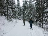 |
The nature park near the town of Ogre is a popular place for leisure, hiking and, in the winter, cross-country skiing. Most of the park is covered with coniferous trees that are on a long and comparatively narrow line of hillocks with steep sides – another element of nature left behind in Latvia by the Ice Age. Many different plants can be found here. The Jaunogres castle hill is one of the most distinct hillocks in the area. |
|
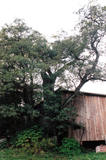 |
This is the thickest Black Alder (Alnus glutinosa) in Latvia
|
|
 |
A restricted area with a set of artificial ponds to the South-west of Saldus. The ponds attract many different kinds of birds during nesting and migration season. The location has not been improved for tourist purposes, but it is still an interesting place for some bird-watching. The forests around the ponds are also home to many protected birds and species of bat. |
|
 |
The Krāču hills (Krāckalni) are a series of
wavy hillocks dating back to the Litorine Sea.
There is a lovely view of Lake Lilijas from here.
Opposite the lake, on the eastern side of the
road, are dolomite stairs which lead to a
monument dedicated to 90 Latvian riflemen who
lost their lives in battles in 1917 in the region.
|
|
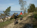 |
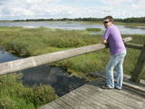
The largest NATURA 2000 territory in Latvia covers 6% of the country’s area. It is located in parts of the Limbaži, Valmiera and Valka districts, and it is a place of an enormously diverse range of landscapes, biotopes and species. The Salaca River is one of the most important rivers in the entire Baltic Sea region in terms of spawning grounds for salmon. The river valley and its sandstone cliffs attract many visitors. It is no accident that this is the second most popular river in Vidzeme for water tourism. The shore of the Bay of Rīga, which is not very long, also features a great diversity in landscapes and biotopes. At the northern end, we find the Randu meadows. In the central part there are sandy beaches, but at the southern end – 22 kilometres of rocky shoreline. The so-called Northern swamps are found on the border with Estonia, while the Seda heath is one of the most important places in the region for birds to rest and feed during migration. The reserve also features a diverse forest in which one can find all of the types of forest which are common in Latvia. Nature trails and viewing towers or platforms are found in the Randu meadows, on the banks of Lake Burtnieks, along the Planči and Niedrāji-Pilka swamps, on the banks of Lake Dziļezers and Lake Lielezers, and elsewhere. The Skaņākalns park in Mazsalaca is one of the most popular tourist destinations in Northern Vidzeme. The territory boasts many important cultural monuments, including one of the earliest known settlements in Latvia – a fishing settlement and burial ground which date back to the 5th to the 2nd millennium BC.
|
|
 |
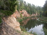
Vairāki dažus metrus augsti smilšakmens atsegumi, kas izveidojušies Stiglavas (Stiglovas) strauta gravas nogāzēs. Kaut arī teritorija tiek popularizēta kā tūrisma objekts, tajā nav īpašu šim nolūkam paredzētu labiekārtojumu. Teritorijas apmeklētāji bojā smilšakmens atsegumus, kas ir aizsargājami biotopi!
|
|


