
| No | Name | Description |
|---|---|---|
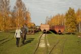 |
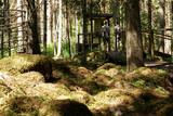
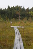
Sedas purva kājnieku maršruts atrodas dabas liegumā Sedas purvs, pārgājienu pa maršrutu iespējams apvienot ar Sedas pilsētas apskati, kas ir unikāls 20.gs. 50.–60. gadu pilsētbūvniecības un arhitektūras paraugs - kūdras purva strādnieku pilsēta. Maršrutam ir divi apļi - Jērcēnu aplis - 5,5 km un Sedas aplis - 4,2 km. Tajos apakatāms izstrādātais kūdras purvs, šaursliežu dzelzceļš, ritošais sastāvs, divi skatu toņi. Rudenī un pavasarī - putnu migrācijas lāikā - interesanta vieta putnu vērošanai. GPS koordinātes: Jērcēnu puses aplim: 57.7055987, 25.7001324; Sedas puses aplim: 57.6699587, 25.7514815. |
|
 |
One of the highest dunes in Latvia, located between Bernāti and Jūrmalciems villages. It is 37m high and offers a magnificent view of the sea and natural pine forests. The highest dunes in Latvia stand to the South of Jūrmalciems village: the Pūsēnu hill, the Ķupu hill, the Mietragkalns or Tiesas hill, the Pāļu hill, the Garais hill, the Ātrais hill, the Lāvas hill. The Pūsēnu dune is the highest of these dunes which are all called hills by the local people. The Pūsēnu hill developed between 1785 to 1835 when shifting sand became extremely dangerous. Several homesteads were buried in sand, among them „Pūsēni”, where a forester’s family lived. The family is said to have moved to Bārta. The dune was named after the buried homestead. Jēkabs Janševskis, a Latvian writer, wrote in his book „Nīca”: “In olden times, large pine trees were growing in the dunes on the coast of Nīca and they stood steady and firm. But i Swedish times (around 1650), the Swedes built a large kiln for charcoal and tar. Pine wood and stumps provided an excellent material for this. Once a big fire rose, and the charcoal kiln burned down as well as the whole pine forest. The remaining stumps and bare trunks in the vast burnout could not hold the storm-driven sand; it flew further and further burying not only the burned-out forest, but also the nearest fields. In wintertime, when the vast, low marshy grasslands were covered with ice, jets of sand drifted further over its surface, and soon most of the grasslands and large meadows turned into sandy heath-land and dunes.” To reconstruct Liepāja, severely damaged during WWII, a silicate brick factory was built in the town. The main raw material was white sand and it was taken from the Bernātu forest. In the 1960-ies they started to dig off the Green Dune and the White Dune, later also the Pūsēnu hill. The excavators used to work day and night, in three shifts. The work stopped at around 1980, as there was no more sand suitable for production of brick. A trail is set up to facilitate walking in the Pūsēnu Dune in the Bernātu Nature Park. |
|
 |
This restricted area protects the highest hillock in the Alūksne highlands – Dēliņkalns Hill – as well as the biotopes on its hillsides. The local landscape is also protected. Downhill ski trails are on the mountain, and its southern side offers lovely views.
|
|
 |
This area was established to protect the cultural and lake-related landscapes of the central section of the Vidzeme highlands, with Lake Alauksts, Lake Inesis, Lake Tauns, etc., with their species and biotopes. There are many important cultural objects in this territory – the Vecpiebalga Lutheran Church, the Vecpiebalga castle ruins, the Vecpiebalga baronial estate, as well as locations where several distinguished figures from the Latvian world of culture have lived and worked. Memorial museums have been established to commemorate them. The lakes are great for fishing, and cross-country competitions are traditionally held in the area of Lake Alauksts during the winter. The Sproģi nature reserve has been established on the islands and peninsula of Lake Inesis.
|
|
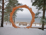 |
A new section of the walking trail along the sea has been built and an environmental object "Sunset watcher" has been created in Saulkrasti near the White Dune and Sunset Trail. It is a photo object where the newlyweds and every guest of Saulkrasti can capture memories in the symbol of the sun, which is so characteristic of Saulkrasti. |
|
 |
The part of the swamp which has mosses, not peat, is important for plover-type birds during nesting season, and goose-type birds during migration.
|
|
 |
Kalētu muižas bijušais medību dārzs. Muižas laikos šeit ierobežotās platībās turēja meža dzīvniekus, kuru medības bija populārs muižniecības izklaides veids. Parkā uzmeklējams piemiņas akmens Krievijas imperatoram Aleksandram III, kurš šeit nošāvis briedi (irsi). No Kalētiem Latvijas teritorijā „ienāca” staltbrieži, kurus medību vajadzībām 1848. g. atveda no Vācijas. Parkā izveidotas takas un atpūtas vietas. |
|
 |
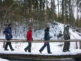
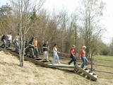
In 2006, a wooden pathway was installed across the Planči swamp – 500m long, which means that the visitor will spend around 20 minutes there. This is probably the only nature trail in Latvia for which there are plans to post information in Braille for people with impaired vision.
|
|
 |
The Kauguri canal dug in 19321933
to divert the waters of the Džukste and
Slampe rivers to the Lielupe River to avoid
broader emergence of swamps.
|
|
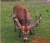 |
he wetland meadows that are around the Pededze River are the site of this 200 ha farm with some 350 red deer, other deer and wild boar. There are towers from which you can watch the graceful animals, and there are ponds for commercial fishing. Please contact the owner well in advance for a tour. |
|
 |
The beginning of this circular trail can be found at the Krimulda church – the oldest in Latvia. In one direction, the tourist will pass along the banks of the little Runtiņupīte river (Runtiņš) to the place where it flows into the Gauja river. Among the points of interest along the way are the parsonage of the church, the Kubesele castle hill, a memorial to the Livonian chieftain Kaupo, the Kubesele cave, the Saulstari rock, the “Great Rock”, ancient anchor blocks, ancient graveyards, a unique labyrinth, etc.
|
|
 |
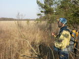
This is a trail for hikers and bird-watchers, located in a very interesting place on the shore of the Bay of Rīga near Kaltene. The visitor will see small inlets and capes and a rocky or overgrown shore. At the end of the trail there is a bird-watching tower. During the spring and autumn migrations of birds, the visitor will see a great many different kinds of birds in the area – geese, plovers, etc. The length of the track is a bit more than one kilometre, and it will take 20 minutes to an hour to cover.
|
|
 |
At the highest point of Krievkalni (149 metres above sea level), there is a good location for relaxation which offers an impressive view toward the East.
|
|
 |
The forest around Kaltene features a natural miracle – the rocks of Kaltene, which are also known as the barrier rocks. The rocks are 2-3 m from the sea and date back to the Ice Age. The Devil’s rock is the largest one. It used to be a beautiful pile of rocks that “stretched to the tops of the trees.” In older maps it is described as being 20 m high. It had many natural rocks, including some that were completely round, while others resembled plates. The rock was almost completely destroyed in the 1960s and 1970s, when it was chopped up to build roads. A fairly small part of the rock survives today, and it is 300 m long and 2 m high. Scientists believe that these rocks used to be sacred locations, because there are many legends and stories about them. There is a forest path with wooden pathways, information stands and a small car park there. (Source: Roja TIC) |
|
 |
This lime swamp of grasses is in an area among dunes which floods from time to time, and it is an important location for many protected plants. The swamp is easily surveyed from the forested dunes which are on the south-eastern side of the swamp. |
|
 |
This path is found on the right bank of the ancient Abava river valley. The visitor will be able to view places where underground streams create wetlands, various kinds of meadows, a stand of juniper bushes, etc. The area is “managed” all year long by “wild” cows. The shore of the ancient valley can be climbed (some 200 steps), and the view is magnificent. It is recommended that the trail be visited in the company of a knowledgeable guide. There is a shorter path that is 600m long, along with a longer one that is more than a kilometre in length. It will take an hour or so to traverse it. Objects are found in the ancient Abava valley nature park.
|
|
 |
The Radžu stone is located to the South of Jēkabpils and at the north-eastern part of the Radžu sand and gravel quarry (the Radžu reservoir). The stone is the second largest rock in Latvia with a size of nearly 100 m3. At one edge of the quarry is the Jēkabpils Forest Park, which is popular among residents and their guests for leisure, hiking and sports. The beach of the reservoir was granted the Blue Flag in 2012. |
|
 |
The small Andrupene swamp is found to the North of the Andrupene Farm Museum in a deep area between hillocks. It is a high-type swamp with an open central part, and it is 130 m long and 120 m wide. There are stands of white alder alongside the swamp. In 2009, the administrators of the Rāzna National Park restored a wooden educational pathway that had been established originally by the Andrupene Elementary School. Today there are stairs, a viewing platform, wooden pathways, and information stands. |
|
 |
Elka Hill is one of the highest surfaces in the western part of the Vidzeme highlands, and it offers a lovely and broad view to the North. There is a small parking lot, a TV and radio tower, and the place where the Gauja River is thought to originate.
|
|
 |
Latvia’s highest hill is the second highest in the Baltic States, but alas, it has only a wrecked viewing tower, so you’ll have to look for the best views on your own. You’ll find some around the tower and the ski trails, particularly Large and Small Golgotha. It is worth hiking the Gaiziņkalns nature trail.
|
|


