
| No | Name | Description |
|---|---|---|
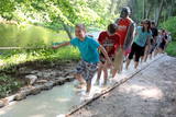 |
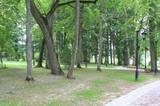
The first barefoot trail created in the Baltic States in the recreation complex "Valguma pasaule", which is located on the forested shores of Lake Valguma. When walking on the path, the feet "massage" sand, wood chips, clay, peat, gravel, cones and various other materials. |
|
 |
A comparatively large swamp to the North of the Zaļā dune, this is an important place for sulphurous waters, just as is the case with Zaļais swamp. The swamp is cut in two by the 3.5 km Ķemeri-Antiņciems road, from which interesting landscapes can be seen. The road is not appropriate for cars, however. To the East of Raganu swamp is Lake Putnezers, which is difficult to access. There is a small car park with an information stand on the shore of Lake Melnezers alongside the Ķemeri-Jaunķemeri road. The historical and overgrown Old Ķemeri road can be used to get to the seashore from this location. |
|
 |
Atrodas Skuķu ezera dienvidrietumu krastā. Sasniedzams no Putnu salas, ejot cauri dzīvei savvaļā pielāgoto mājlopu aplokiem un taku. No torņa labi pārskatāma Dvietes paliene (ūdeņainos pavasaros pārplūst) un aizaugušais Skuķu ezers. Laba putnu vērošanas vieta. Putnu salas Atālu mājās – vietējais gids. |
|
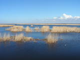 |
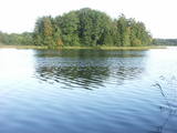
This is a shallow lagoon-type lake which, along with the area around it, is a wetland of international importance. The presence of 271 species of birds has been found in the area, including 43 birds which are listed in the Latvian Red Book and 15 that are listed in the European Red Book. The nature park includes the Nida swamp and the part of the sea which is alongside the park - newly estabilshed sea protected area "Nida - Pērkone". Between Lake Pape and the Baltic Sea we find Latvia’s oldest bird ringing station, where rings are attached not only to birds, but also to bats. Lake Pape is the first territory in Latvia where livestock adapted to life in the wild have been released for the proper management of the lake’s flood-land meadows. First there were wild horses (“Konik” horses), then aurochs and the European bison. Visitors can use bird and nature observation towers, nature trails, etc. The Ķoņi village is a unique example of a seaside fishing village. Pape is popular among bird-watchers, and the park’s visitors centre is found in the “Nature House” of the Worldwide Fund for Nature. |
|
 |
This is a natural monument of protected dendrological plants. The park is in the Upmala Parish, covers 2.7 ha, has been protected since 2001 and is managed by the Vārkava Administrative District Council. Judging from the oldest oak trees (approximately 200 years old), the park was established in the early 19th century, with other plants from the latter part of the century. Local species of trees, including maples, elms, fir trees, aspens, oak trees, willow trees, linden trees and hazelnut trees grow in the park, as do more than 10 exotic types of trees and bushes, including various types of maple, aspen, willow, lilac and linden trees. |
|
 |
This restricted area protects Lake Jumurda, which is in the central part of the Vidzeme highlands, along with its three islands, the local broadleaf forests, and the surrounding landscapes.
|
|
 |
This is a large, outstanding and expressive tree, Latvia’s thickest Norway Maple (Accer platanoides).
|
|
 |
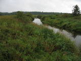
This territory is on both sides of the central section of the Raķupe River. On the banks of the river, there are many different meadow habitats, as well as massive oaks growing in the places of former farmsteads which are uninhabited by now. This is an important place for rare plants and animals. There is no tourism infrastructure for visitors in the area. Visitors who are especially interested in the environmental cognition are advised to visit the territory in attendance of experienced local guide. Raķupe is not usable for water tourism because of tilts of trees and beaver dams. |
|
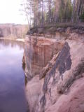 |
These sandstone cliffs were once known as the Pieškalni or Pieškaļi cliffs. They are around 7 km to the North from the centre of Cēsis. These are the most monolithic sandstone cliffs in the Baltic States – around 700 m long (with some 330 m along the Gauja River) and a maximum height of 22 m. There is a viewing area which offers a grand view of the Gauja River valley. Water tourists will boat up to the majestic wall of the cliff and will be surprised at what they see! The name of the cliffs, Ērģeles, is the word for "pipe organ" in Latvian, and the name was supposedly given to the cliffs because of the echoes which can be heard there – they reputedly sound like an organ. Hikers and boaters must be very careful when in this area – please make sure that you are safe! Please note, too, that the infrastructure of the cliff is scheduled to be renovated in 2012. |
|
 |
The barrow which offers a good view is at the northern end of the Dunduri meadows – at the end of Melnragi. It is an artificial barrow which follows along with the bed of the little Slampe River. The meadows are home to livestock allowed to live in the wild, and you can see a bit of the restored Slampe. The view is particularly interesting during flooding season, when the surrounding wetlands become saturated. This is a location for bird-watching.
|
|
 |
The trail tells about grey dunes which have survived thanks to the border restrictions and the presence of military. The trail starts from the parking place at the mouth of the Užava river. It is one of the few natural rivermouths in Europe. One can also see the „tacis”, an industrial installation for lamprey (Lampetra fluviatilis) fishing during their spawning migration period. The 3km long trail is circular. It winds for 1.5km from the Užava rivermouth to the North, along the coastline (the beach is covered with sand and pebbles), and returns to the starting point by a gravel road through grey dunes. Along the trail, one can observe a distinct white dune with rare plant species Linaria loeselii, Lathyrus maritimus, Anthyllis arenaria, Tragopogon heterospermus. About 1km from the rivermouth, in the sea, one can see a wrack of a sailing ship (parts of frame). The visibility depends on the flow of sand in the sea. The way back opens a beautiful view of the range of grey dunes. Unfortunately, Scots Pine starts taking over the area. There are three important biotopes of EU significance: „Fixed dunes with herbaceous vegetation 2130”, „Decalcified fixed dunes with Empetrum nigrum 2140” and „Dunes with Salix arenaria 2170”, forming a unique mosaic. Typical species here: mountain Alison ‘(Alyssum gmelinii), Pasqueflower (Pulsatilla pratensis), Sand Pink (Dianthus arenarius), Rosemary Leaved Willow (Salix rosmarinifolia), Dark Red Helleborine (Epipactis atrorubens), Kinnikinnick (Arctostaphylus uva-ursi). As a former military site, some military constructions can be seen here like horseshoe-shaped sand ramparts by the road in gray dunes. They were built to disguise military vehicles in case of sea attack. By the Kangroti graveyard, towards the Užava river, there is an underground pillbox. It is a one-man fortification to fire along the coastal perimeter. The Mouth of River Užava walking route is in the nature reserve „Užava” |
|
 |
Одна из наиболее высоких дюн нашего побережья. В советское время в дюне велись копательные работы, так как песок использовался для производства силикатного кирпича. В 80-е годы ХХ века копательные работы были прекращены. Самая высокая часть дюны (хороший вид) сохранилась и поросла сосновым лесом. Создана природная тропа горы Пусену. Находятся в Бернатском природном парке. |
|
 |
This territory is meant to protect the large hillocks and lakes of the Augšzeme highlands – Lake Svente, Lake Medums, Lake Ilga and others, with their islands, landscapes and species. The nature park which has been established around Lake Svente and Lake Medums is part of this territory, and there are several areas that are restricted for environmental reasons – Lake Bardinskis, Lake Skujine, and the islands of Lake Medums and Lake Svente. There is a viewing tower on Egļukalns Hill, along with downhill ski routes. |
|
 |
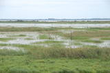
Palieņu pļavas starp Rūjienu un Rūjas ieteku Burtnieku ezerā, kurām raksturīga liela augu un putnu sugu daudzveidība. Tās robežojas ar bijušiem Rūjas zivju dīķiem, kas šobrīd aizaug ar mežu. Rūjas palienes var vērot gan braucot ar laivu pa Rūju, gan arī no ceļa, kas ved uz minētajiem dīķiem. Tur izvietots informācijas stends.
|
|
 |
The Lake Lubāns, wetland of Lubāns. Lubāns (80.7 km2) is the largest lake in Latvia and the most popular
lake and wetland in Europe. The lake and the wetland has biodiversity; a unique place not only in Latvia,
but also internationally. Nature Reserve is included in the European Union network of protected areas and
NATURA 2000 under the Ramsar Convention criteria as the wetland of international importance. Lubāns wetland,
called marshy meadows, includes bogs, wet meadows and wet forests. In autumn and spring the lake
attracts thousands of migratory waterfowl which is easily to wach from the bird observation towers or the terrace
of water tourism development center.
|
|
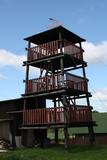 |
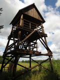
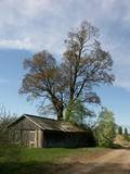
This is an interesting viewing tower which is part of one of the farm buildings. It offers a lovely view of the surrounding area.
|
|
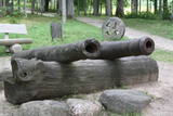 |
Established in 1900 at the place where the Pērse River flows into the Daugava (now the reservoir of the Pļaviņas hydroelectric power plant), the park offers a look at 17th century Swedish cannons and monuments from Medieval graves. Next to the high school in the park is a restored fountain, “Head of a Faun,” which was near the legendary Pērse waterfall during the 1930s. The waterfall is now underwater, but its location is indicated by a stone sculpture, “Girl of Pērse,” which was created by the sculptor Juris Zihmanis. A path leads to an 11 metre high wooden sculpture, “For Eternity,” by the sculptor Ģirts Burvis, and another sculpture, “Little Owl,” which is the work of the Rurāns brothers, both of whom are sculptors of wooden sculptures.
|
|
 |
Īdeņa Castle mound is located near Lake Lubāns. A beautiful view
to the lake and to the marshy meadows. The place was inhabited from
the 11th century.
|
|
 |
This small restricted area protects the Swedish juniper and the lime meadows in which it grows. There is a marked circular trail which allows visitors to study one of the few but excellent stands of juniper in Latvia. The bushes are 50 to 70 years old, and all around them are interesting habitats, plants and animals. Natural stands of juniper in the Baltic States are the result of farm work such as reaping, chopping, etc., as well as of herding of sheep and other livestock. A small part of the area is still “managed” by sheep. Unfortunately many junipers have died because of overgrowing of territory. |
|
 |
Ķekavas novada Daugmales pagastā atrodas pastaigām un dabas baudīšanai piemērots mežs, kurā baudīt dabas daudzveidību. |
|


