
| No | Name | Description |
|---|---|---|
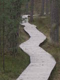 |
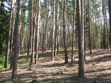
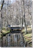
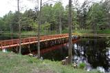
One of the most attractive and informative nature trails in the environs of Rīga. It leads the visitor around the 17-metre Ragakāpa dune, which is most interesting. People can learn about the habitats of the dune areas and the plants and animals of the area. Some of the pine trees are as much as 100 years old and more. The trail is 2km long in each direction and will take some two hours to traverse. This is part of the Ragakāpa nature park.
|
|
 |
Atrodas Kalēju ielas malā. Savu popularitāti ieguvis ar nostāstu, ka Ziemeļu kara laikā pie tā pusdienojis Krievijas cars Pēteris I un Polijas valdnieks Augusts (Stiprais). |
|
 |
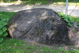
There is no need to enter the bog to see it, there are good views from the highway Ventspils – Riga (77 km, bus stop “Pagrieziens uz Elkskeni”). The main value of restricted area is chalky fen bog with brown bog-rush (greatest habitat finding in Latvia). Be careful when stopping on the highway – mind the traffic! A couple of kilometers towards Riga, on the right side of the highway, there is sign to Grizu Velna kresls ( Grizu Devil Chair) which is an attractive boulder (protected).
|
|
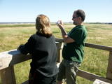 |
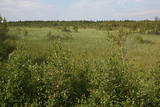
The key treasure in this park is that it has a lake that is one of the most intensive sites for birdwatchers in all of Latvia. It also features outstanding flora and the shallow waters of the Bay of Rīga. Recommended: Hike along the seashore from Mērsrags to Engure (20 km). See wild domestic animals (horses and cows) on the eastern shore of Lake Engure. There’s a bird-watching tower on the NW shore of the lake (approach from Kūļciems, where you can see domestic animals adapted to life in the wild, including the Blue Cows of Latvia). A bird-watching tower can be found at a place called Jomiņa near Mērsrags, where the seashore meadow is an uncommon biotope
|
|
|
|
Atrodas austrumos no Alūksnes Tempļa kalna un dienvidos no Lieliem kapiem – Tempļa kalna parkā. Skatu torņa platforma atrodas apmēram 30 m augstumā virs Alūksnes ezera ūdeņiem. Labi redzama Marijas sala, Alūksnes parks, Alūksnes ezera piekraste līdz Kolberģim un Lāzberģim. Izcili ainavisks skats! |
|
 |
Aizaudzis un purvains ezers - Ļūbasts, ar grūti pieejamiem vai nepieejamiem krastiem. Dabas vērošanai šobrīd nepiemērota vieta. Galvenās aizsargājamās vērtības - dažādas putnu sugas, t.sk. dzērves un melnie zīriņi.
|
|
 |
Iespaidīga smilšakmens atsegumu virkne, kas
izveidojās pēc 2005. g. orkāna.
|
|
 |
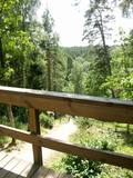
The recently renovated viewing tower offers a wonderful view of the impressive and forested ancient Gauja River valley. The Gūdu cliffs are visible. This is part of the Līgatne nature trails territory, where there are wide paddocks of wild animals.
|
|
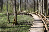 |
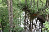
The excessively damp forests at this place include the Vēršupīte River bog, and this is one of the most diverse biotopes in Latvia in terms of the number of species that can be found here. The fact that the area is regularly flooded is shown by the fat roots of black alders – indeed, the place looks like a stand of mangroves. The wooden pathway that is the Dumbrāju trail starts at the Forest House for those who wish to examine the bog. The most impressive views are seen during spring floods or rainy seasons at other times of the year. The little river breaks out of its bed and floods a large territory. The Lake Sloka hiking trail is another place where you can study the Vēršupīte bog. The circular trail is 3 km long, and its beginning is at the Lake Sloka bird watching tower. |
|
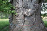 |
Most of the great tree’s mighty branches are gone, and among those that are still there, the thickest ones are held up by supports, and the tree’s hollow centre is protected against snow and rain with a little roof. This is the thickest Common Oak (Quercus robur) in Latvia and the Baltic States. Indeed, it is one of the thickest oak trees in all of Northern Europe. The tree is a gorgeous part of the surrounding landscape. There is a car park and an information stand nearby.
|
|
 |
Vēršupīte is a small river which curves through the
town of Ķemeri and has more than 10 small and
romantic bridges across it – each with its own name.
|
|
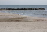 |
This is an enormously important territory for migrating birds. The most commonly spotted protected species of birds are the velvet scoter, the black scoter, the long-tailed duck, the little gull, the red-throated and black-throated loon, and the black guillemot. The territory is opposite the Dundaga and Ventspils administrative districts, and it covers 172,412 hectares.
|
|
 |
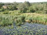
The Dviete Wetlands Nature Park contains a unique natural territory – the ancient Dviete River valley with the Lake Skuķi and the Lake Dviete and the surrounding wetland meadows. During flooding season, these wetlands store up waters from the Daugava River. They absorb a lot of floodwater at first and then slowly return it, thus reducing the level of floods in the Daugava River valley. This process is the reason for the unique ecosystem which exists in this area. It is an important location for plants and birds both during migration and nesting season. The river valley is important for birds during migration and nesting. In 2006, wild cows were released into the meadows. There is also work to improve the tourist infrastructure in the area. |
|
 |
Ģeoloģiskā taka sastāv no trīs saistītiem posmiem: „Melturi – Kārļu zivjaudzētava”, „Kārļu zivjaudzētava – Zvārtes iezis” un "Zvārtes iezis - Veclauču tilts". Amatas senleja veidojusies vienlaikus ar Gaujas senleju leduslaikmeta beigu posmā un pēcleduslaikmetā, ledāja kušanas ūdeņiem plūstot uz Gaujas ieleju. Gaujas NP teritorijā Amatas senielejas dziļums sasniedz 50 metrus un platums palielinās līdz apmēram 1-1,5km.
Augstas kraujas (vairāk ne kā 40 metru), kurās redzami augšdevona Pļaviņu svītas dolomītu un augšdevona Amatas un Gaujas svītu smilšakmeņu atsegumi, mijas ar mežiem apaugušām, 3-16m augstām stāvām terasēm.
Amatas senieleja ir nozīmīga ne tikai ar savām dabas ainavām. Tās krastus grezno dolomīta un smilšakmens atsegumi, kas atklāj zemes vēstures lappuses 350-400 miljonu gadu tālā pagātnē, kad Latvijas teritoriju klāja jūra.
Velobraucieniem taka nav piemērota!
|
|
 |
This is an artificial body of water that was dug in the 1960s to obtain ice for fish processing plants in Kolka. |
|
 |
This territory is on both sides of the central section of the Raķupe River. On the banks of the river, there are many different meadow habitats, as well as massive oaks growing in the places of former farmsteads which are uninhabited by now. This is an important place for rare plants and animals. There is no tourism infrastructure for visitors in the area. Visitors who are especially interested in the environmental cognition are advised to visit the territory in attendance of experienced local guide. Raķupe is not usable for water tourism because of tilts of trees and beaver dams. |
|
 |
This is a territory which regularly floods when the Lielupe River crosses its banks. These are flood-land meadows of importance to birds. The area can be surveyed from the Rīga-Liepāja highway and the Kalnciems road which runs along it. |
|
 |
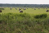
Natural flood-land meadows along the banks of the Lielupe before Jelgava. Many protected plants are found here, and birds nest and rest here during migration season.
|
|
 |
Open landscape area within farming lands on both banks of Uzava River about 10 km before it flows into the Baltic Sea. There is a good open view over the area from the Vendzava-Ziri road going through the nature park. Protection of migratory birds and corncrakes has been one of the main reasons for establishment of the nature park. Bird watching is possible from the road Vendzava-Ziri during migration period in spring and fall. There is no tourist infrastructure in the nature park.
|
|
 |
The tower is on the banks of the little Tērvete River, with a view of the river valley and surrounding forests. Good views of the Tērvete River valley are also available from the nearby Zviedru Hill and the Tērvete castle hill. Note: The viewing tower at the Tērvete Ancient History Museum is not open to visitors!
|
|


