
| No | Name | Description |
|---|---|---|
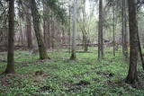 |
One of the rare places (see also Rucavas ivju audze) in Latvia where two rare and protected wild tree species grow - yew-tree and Baltic ivy. Territory is not marked on site with information signs or stands therefore it is hard for visitors to find. Not usable as tourism object.
|
|
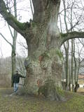 |
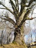
This tree is in the park of the Sēja Estate and is one of the four trees in Latvia that have a circumference of more than four metres.
|
|
 |
The nature trail was built in 2003 supported by the WWF, the Latvian Environment Protection Fund, the International volunteering organization supporting conservation initiatives in the United Kingdom (BTCV) involving volunteers from Nīca and Rucava municipal parishes. The trail exposes the surrounding landscapes and related biotopes – dunes, forest, grasslands and bog, as well as bird and animal species found there. On the trail, there is a bird watching tower and two birdwatcher hides. You can see the rivers Paurupe and Līgupe, beaver activity areas, grasslands, black alder forest, spruce forest, floodland, wild horses, aurochs, the Šķilu lime tree, the Holy Grove, the Ezerskolas sacrificial stone, the Pape ornithological field station, the Papes polder grasslands and the Pape lighthouse. There are resting places en route. The trail leads through the historical Ķoņu village with the traditional coastal fishing village architecture of buildings and yards. The trail is 9 km (5 km one way by a gravel road, returning 4km along the coastline). The trail is in the Pape nature park
|
|
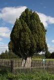 |
This is the thickest common juniper (Juniperus communis) in Latvia and the Baltic States. It stands in the middle of a field and looks wonderful. The tree is sometimes known as the Rieteklis juniper, because the Latvian poet Rieteklis (Jūlijs Eduars Balodis, 1856-1940) like to sit under it.
|
|
 |
Aptuveni 2km garā Ķirbižu meža izziņas taka izveidota apļveidā gar Vitrupes abiem krastiem. Visā takas garumā var mācīties atpazīt Latvijas mežu raksturīgākos kokus, krūmus un augus. Šeit var aplūkot arī Vālodzes dižozolu (6.5 m). Upes labajā krastā, pie tā sauktā vīna pagrabiņa un kreisajā krastā apmēram 200 m no takas sākuma pie Meža muzeja, atklājas ainaviski skati uz ieleju un Vitrupi. |
|
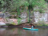 |
The Brasla River flows through a lovely valley that is approximately 300 m wide and up to 30 m deep. It is near the Inčukalns-Valka highway. The river has among the most beautiful rapids in the country, with mighty cliffs (the Brasla cliffs) that can be seen at nearly every curve in the river (except along the lowest reaches of the river). During the winter, various unusual frozen waterfalls can be seen in some of the cliffs, including the Krauļukalns cliff and the Jāņavārti cliff. On the left bank of the Brasla, opposite the Brasla fish farm, there are the Aņīte cliffs -- a series of sandstone cliffs that are 1 km long. The cliffs are between 2 and 35 m in height, and the sandstone cliffs are separated by ravines. On the right bank of the Brasla, there are major cliffs such as the Vāršavu cliff, the Kraukļukalns cliff, the Jāņavārti cliff, the Slūnu cliff, the Virtaka cliff and the Buļi cliff. How can you best learn about them? Boat down the river from the aforementioned highway or even from Straupe, which is further upstream. An alternative is hiking down the right bank of the river, though please take into account that the terrain is fairly extreme, and you are going to have to think about what to do when you arrive at the place where the Brasla River flows into the Gauja. |
|
|
|
Latvijas Valsts mežu laivu bāzē, kas atrodas Kaņiera ezera dienviddaļā (redzama no Lapmežciema – Antiņciema ceļa) kopā ar laivu bāzes ēku apvienots skatu tornis, no kura lieliski pārredzama ezera austrumdaļa. |
|
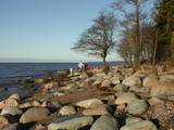 |
Neliels, bet ļoti ainavisks un ar lieliem laukakmeņiem klāts
zemesrags. No raga iztālēm redzamas Veczemju
klintis.
|
|
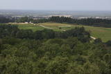 |
The wooden tower was built and stands 28 metres high. It is at the top of the highest hillock of the Northern Courlandian Highlands – Kamparkalns Hill (175 metres above sea level). The tower offers one of the loveliest views in the region of the hillocks of Talsi. On a clear day, you can see all the way to the Bay of Rīga and Talsi. |
|
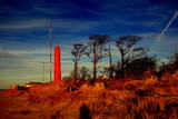 |
Akmensraga tāpat kā Kolkasraga apkaime jau kopš seniem laikiem ir bijusi zināma kā kuģotājiem bīstama vieta, jo te atrodas viena no lielākajām Latvijas piekrastes kuģu kapsētām. Bīstamības fakts slēpjas apstāklī, ka Akmensraga apkārtnē mainās krasta virziens un jūrā iestiepjas akmeņaini sēkļi. Pirmo signāluguni Akmensragā iededza 1879. g., bet 10 gadus vēlāk uzcēla 28 m augstu koka bāku. 1911. g. uzcēla mūra bāku, kuru sagrāva 1. pasaules kara laikā – 1916. g. Mūsdienās redzamā (augstums 37,5 m, uzbūvēta 1921. g.). Padomju laikā visas bākas bija militāri – stratēģiski objekti un šeit strādāja hidrogrāfiskais dienests un jūras novērošanas punkts. Bākas apkārtnē - mežā vēl joprojām redzamas bijušās padomju armijas ēku drupas. Apskatāma no iekšpuses. |
|
 |
К северо-востоку от Мазирбской лютеранской церкви – в полемежду храмом и домом «Пакални» видны два чумных камня. На поверхности бóльшего был высечен (сейчас стерся) текст о ливах, которых одолел король Швеции Карл IX и чума. Сбоку на большой камень опирается второй (самый маленький) чумной камень, который в свое время был установлен у близлежащих домов. Стертый текст рассказывал об армиях, ходивших по Курземе, о голоде и чуме. Третий – Большой чумной камень находится заМазирбским имением священника. Высеченный на нем текст (еще немного просматривается) повествует будущим поколениям о местном священнике (умер во время чумы) и о создании пастората в Сикрагсе. Одновременно камень является памятником шести пасторам обширной окрестной общины. Все три камня повествуют о Большой эпидемии чумы 1710 года, и тексты высечены на них в период с 1711 по 1734 год. |
|
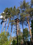 |
Uzcelts apkaimes augstākajā vietā – Ančupānu meža kalnā, kuru vietējie dēvē par „Bāku”. No 26 m augstā torņa redzama ļoti plaša panorāma ar Rēzeknes pilsētas namiem, baznīcu torņiem un apkaimes mežu masīviem, kas mijas ar lauksaimniecībā izmantojamām zemēm. Blakus tornim – atpūtas vieta. |
|
 |
One of the highest dunes in Latvia, located between Bernāti and Jūrmalciems villages. It is 37m high and offers a magnificent view of the sea and natural pine forests. The highest dunes in Latvia stand to the South of Jūrmalciems village: the Pūsēnu hill, the Ķupu hill, the Mietragkalns or Tiesas hill, the Pāļu hill, the Garais hill, the Ātrais hill, the Lāvas hill. The Pūsēnu dune is the highest of these dunes which are all called hills by the local people. The Pūsēnu hill developed between 1785 to 1835 when shifting sand became extremely dangerous. Several homesteads were buried in sand, among them „Pūsēni”, where a forester’s family lived. The family is said to have moved to Bārta. The dune was named after the buried homestead. Jēkabs Janševskis, a Latvian writer, wrote in his book „Nīca”: “In olden times, large pine trees were growing in the dunes on the coast of Nīca and they stood steady and firm. But i Swedish times (around 1650), the Swedes built a large kiln for charcoal and tar. Pine wood and stumps provided an excellent material for this. Once a big fire rose, and the charcoal kiln burned down as well as the whole pine forest. The remaining stumps and bare trunks in the vast burnout could not hold the storm-driven sand; it flew further and further burying not only the burned-out forest, but also the nearest fields. In wintertime, when the vast, low marshy grasslands were covered with ice, jets of sand drifted further over its surface, and soon most of the grasslands and large meadows turned into sandy heath-land and dunes.” To reconstruct Liepāja, severely damaged during WWII, a silicate brick factory was built in the town. The main raw material was white sand and it was taken from the Bernātu forest. In the 1960-ies they started to dig off the Green Dune and the White Dune, later also the Pūsēnu hill. The excavators used to work day and night, in three shifts. The work stopped at around 1980, as there was no more sand suitable for production of brick. A trail is set up to facilitate walking in the Pūsēnu Dune in the Bernātu Nature Park. |
|
 |
The Grey Dune of Pāvilosta nature reserve covers 42 hectares of land and has been designated to protect Latvia’s widest dune (1.5 km parallel the seacoast, and 812m in the direction from the sea to inland) and the biotopes and species found there. A two-storied watching platform is built to savour the scenery. In Soviet time, local fishermen used to dry seaweed in dunes for production of agar, and thus rich vegetation developed in the dune. The Gray Dune is part of a unique landscape with the sea view, the traditional architecture of Pāvilosta fishing town, and biotopes, including protected, which border the nature reserve: pine forest, embryonic dunes, white dunes, and wet beech where once can find springs. Biotope 2130, “Fixed dunes with herbaceous vegetation (grey dunes)” is found here. At present, pines are taking over the biotope, therefore some maintenance activities are required. The Grey Dune is most beautiful in the second half of July and in August when the blossoming Breckland Thyme (Thymus serpyllum) and Narrowleaf Hawkweed (Hieracium umbellatum) colour the dune in shades of yellow and violet. The most typical species here are Pasqueflower (Pulsatilla pretense), Grey Hair-grass(Corynephorus canescens), Blue Hair Grass (Koeleria glauca), Sand Pink (Dianthus arenarius). The Gray Dune earned wide recognition when a group of enthusiasts actively campaigned for six years to achieve the status of the nature reserve. Guna Grimsta, a group representative remembers that they organised events and activities throughout Latvia involving large part of the society, prominent personalities, church parishes, NGOs, school youth and university students. The activists were writing letters, making videos, doing research articles, composing music, collecting signatures and submitting proposals to achieve official status of the Grey Dune as an especially protected nature site. They organised seminars, concerts, art plenaires and exhibitions, educational excursions, joint-work, musical church services, meetings with high officials and their on-site visits to the Gray Dune. In 2006 the group received the title „Proudness of Latvia” awarded by the national TV3 broadcasting company and daily paper „Diena”. |
|
 |
From the Asote castle hill, which is on the right bank of the Daugava River near Jēkabpils, there is a fine view of the Daugava River valley, the Ābeles Island, and the Kaupre castle hill that is at the northern end of the island.
|
|
 |
Ap 7 km garā apļveida taka sākas pie leģendārajām Mangaļu mājām. Tā iepazīstina ar latviešu strēlnieku kauju vietām, vietām, kur atradušās to fortifikācijas, t.s. „Vācu valni” u.c. liecībām. Mangaļu mājās – Ziemassvētku kaujām veltīts muzejs. |
|
 |
One of the most beautiful areas along the Venta River and its tributary, the Šķērvelis River. The river valleys and gullies along them are quite deep, and dolomite and sandstone cliffs can be spotted here and there. There are also rapids on the river. The largest cliffs in Kurzeme – the Ātraiskalns and Gobdziņi cliffs – can be seen on the banks of the Venta. The Lēni Catholic Church is near the restricted area. There are no tourist elements in the restricted territory at this time. The Venta is a popular destination for water tourists, however, from Nīgrande to Kuldīga. |
|
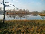 |
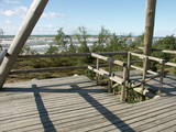
Cena's heath swamp's trail was made to introduce vistors to one of the most beautiful things in nature - a moss swamp. The pathway goes not only around beautiful swamp lakes but also meets the degraded part of the swamp. At the beggining and the end is a watch tower. |
|
|
|
Atrodas sporta un atpūtas kompleksā „Trīssaliņas”. No torņa paveras pievilcīga apkaimes ainava, kas īpaši skaista ir pieneņu ziedēšanas laikā. |
|
|
|
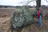
The Boulder of Subinaite can be found in Sakstagala rural municipality opposite Vaļenieku House that
is on the left side of the river Rēzekne. The base of the boulder is below the river level; it is 5,2 m long, 4,4
m wide, it rises about 1,6 m above the water level, about 2,5 m below the water level, capacity 26 m3.
Reddish surface is heavily eroded and full of moss. Protected since 1977.
|
|


