
| No | Name | Description |
|---|---|---|
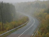 |
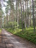
The tower is at the edge of the Dundaga-Mazirbe road, at the Šlītere Blue Hills. It offers a lovely view of lowland seashore forests, the local road, and a bit of the ancient shore of the Baltic ice sea.
|
|
|
|
Atrodas austrumos no Alūksnes Tempļa kalna un dienvidos no Lieliem kapiem – Tempļa kalna parkā. Skatu torņa platforma atrodas apmēram 30 m augstumā virs Alūksnes ezera ūdeņiem. Labi redzama Marijas sala, Alūksnes parks, Alūksnes ezera piekraste līdz Kolberģim un Lāzberģim. Izcili ainavisks skats! |
|
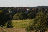 |
The hill is the highest point on the shores of the little Slocene River valley, and it is located in Tukums, at the side of Jelgavas Street. It opens up a broad view of the Slocene River valley and the town of Tukums with its historical centre on the opposite side of the valley. The view is particularly interesting in the evening, when the town is lit up. There is a monument to the liberators of Tukums.
|
|
 |
The River Ķīšupe (length – 31 km) begins its journey in the marshlands of Lēdurga Parish. As the river reaches the seashore, its bed and the location of its mouth often changes. One of the tributaries of the Ķīšupe carries a rather interesting name – Pupaļurga. The name of the River Ķīšupe probably comes from the name of a man and his house. In the 17th century a man named Ķīsis (in English: ruffe) used to live by the river. |
|
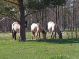 |
Für den Zweck der Bewirtschaftung der Niederungsauen des Pape-Sees und der Vermehrung der biologischen Vielfalt sind hier Konik-Wildpferde angesiedelt wurden. Die kann man mit einem örtlichen Guide kennenlernen. |
|
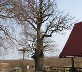 |
Turbu dižozols aug Mazās Juglas stāvkrastā, atpūtas kompleksa Turbas teritorijā. Dižozols ir aptuveni 800 gadu vecs, tā apkārtmērs ir 7,1 m, augstums - 27 m, vainags 18x16 m. Dižozols ir ļoti labā stāvoklī. Zaļo viss vainags. Ozolā ligzdo pūce, kā arī iecienījuši daudzi citi putni. Zinātāji runā, ka Ozols ir ar spēcīgu dziedniecisku enerģiju. |
|
 |
The Slocene River flows through Lake Valgums and Lake Mazezers before flowing into the western part of Lake Kaņieris. It is part of a branched and swampy delta in which there are seasonal restrictions aimed at protecting birds. The wetlands which are alongside the river are difficult to access in many places. Before the Starpiņupīte was dug between Lake Kaņieris and the Bay of Rīga (the water level is regulated with sluices), the water from the river flowed along what is now the Vecslocene River all the way to Sloka, where it ended at the Lielupe River. The Vecslocene can be used by canoe boats only when the water level is high and then from the Old Ķemeri road to the place where the river enters the Lielupe. Between Milzkalne and Lake Valgums, the river is not navigable because of many fallen trees. During the springtime, the estuary of the Starpiņupīte is a good place for bird watching. |
|
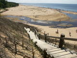 |
The White Dune is one of the landmarks of Saulkrasti, on the Vidzeme gulf coast. The dune offers a splendid view of the sea, the mouth of the Inčupe River and the vast beach. The White Dune formed as the wind drove beach sand over the clay silt of Baltic Ice Lake. Its white 18 meters high sand outcrop once helped local fishermen find their way home. The dune got its name from its white, hardened layers of sand which look like sandstone. |
|
 |
Similar as Alsungas mezi (Alsunga forests) – is not intended and appropriate for visits. A narrow path of the restricted area can be seen from the gravel road – Saka-Apriki. Nature restricted area established mainly for protection of Erica tetralix (often called "cross-leaved heath") and it is one of the most important growing places.
|
|
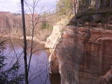 |
The viewing area on the Ērgļi (Ērģeles) cliffs offers an impressive view of Latvia’s most monolith sandstone cliffs (up to 22 metres high) – this is the highest location in the Gauja River valley. Please be very careful and don’t go anywhere near the edge of the cliff!
|
|
 |
Taka ved cauri mežam uz skatu torni purva malā. Takā apskatāma Nāzara priede –priede, pie kuras 1905. gadā nošauts dumpinieks, pati priede – ekoloģiskais koks ar dzilnu kaltiem dobumiem, nokaltusi. Melnalkšņu dumbrājs - slīkšņa ar cūkaušiem un puplakšiem. Oleru purvs no skatu torņa – pārejas un sūnu purvs, kas izveidojies nolaista ezera vietā. Papildus objekti blakus takai, pieejami pa ceļu – Oleru muižas komplekss, Krustakmens, Oleru muižas kapi. Kopējais takas garums: 1,1 km. |
|
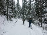 |
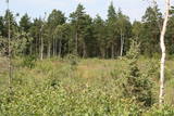
The nature park near the town of Ogre is a popular place for leisure, hiking and, in the winter, cross-country skiing. Most of the park is covered with coniferous trees that are on a long and comparatively narrow line of hillocks with steep sides – another element of nature left behind in Latvia by the Ice Age. Many different plants can be found here. The Jaunogres castle hill is one of the most distinct hillocks in the area. |
|
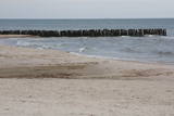 |
This is an enormously important territory for migrating birds. The most commonly spotted protected species of birds are the velvet scoter, the black scoter, the long-tailed duck, the little gull, the red-throated and black-throated loon, and the black guillemot. The territory is opposite the Dundaga and Ventspils administrative districts, and it covers 172,412 hectares.
|
|
 |
Established: 1959
60 coniferous and 350 deciduous trees
Brief description: Between the Tukums-Kolka road, the Lāčupīte stream and the sea, Igors Mednis has planted a series of foreign trees and shrubs. He has conducted experiments to see how different foreign plants adapt to different conditions. The best time to visit is in May and June, when the rhododendrons are in bloom.
|
|
 |
This is a territory which regularly floods when the Lielupe River crosses its banks. These are flood-land meadows of importance to birds. The area can be surveyed from the Rīga-Liepāja highway and the Kalnciems road which runs along it. |
|
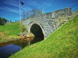 |
Takas sākums atrodas Vidagā, vietā, kur uz Vizlas celts vēsturiskais akmens arkas tilts. 1,2 km garā taka bez marķējuma ved gar pašu upes krastu līdz pat ietekai Gaujā. Redzami skaisti dolomīta atsegumi, nelieli krāčveidīgi ūdenskritumi un iespaidīgais Žākļu dižakmens. |
|
 |
The Kaļķupe River valley was established as the Pilsupe River (formed by Kaļķupe River and Mazupe River) crossed the Blue hills of Šlītere to the South of Vīdale and Kaļķi. The distinct river valley has a branched network of gullies in which Devonian sandstone has been uncovered and can be seen in some locations. Puiškalns Hill (located at confluence of Kaļķupe River and Mazupe River), which was used as a castle hill and as a sacred location long in the past, is one of the most distinctive parts of the area. It is a popular tourist destination in the Talsi District. Hillside forests, various kinds of meadows and a wide range of plants are also of value in the local environment. |
|
|
|
Viena no augstākajām Latvijas celtnēm ar vienu no augstākajiem skatu laukumiem (65 m). Paveras izcila Vecrīgas un Rīgas ainava, kā arī Daugavas (līdz Rīgas HES dambim) un Pārdaugavas skati. Labi redzami blakus esošie Rīgas centrāltirgus paviljoni. |
|
 |
Zīleņu Sacrificial Boulder.You will find it on Zelenpole Golden hill beside the escarpment. The boulder
has an annular curvy. It was an ancient Latgalian cult place where people sacrificed to Gods, released themselves
from the bad things and took a positive energy.
|
|
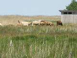 |
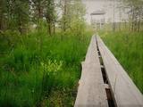
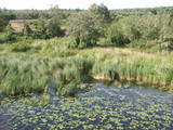
Overgrown with reeds, full of seashore meadows, lagoons, muddy little lakes and sandy shallows – this is the part of the Bay of Rīga shoreline which runs between Ainaži and Kuiviži. The Randi meadows are an important location for birds and plant life. It is a protected habitat with environmental restrictions. A bird-watching tower and nature trail have been installed so that visitors can study the meadows. The tour will take around one hour to complete. Objects are in the Northern Vidzeme Biosphere Reserve.
|
|


