
| No | Name | Description |
|---|---|---|
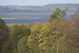 |
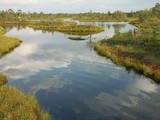
Nature restricted area includes eastern side of the lake with Lanupe River and North-east and South-east coastal areas. Restricted area has been established for protection of birds and floodplain meadows of the lake. To see the nature restricted area visitors do not have to enter it. There are great view points with wind generators of Grobina on the background from the road Vecpils – Rava – Aistere. Coastal areas which are not included in the restricted area are perfectly suitable for bird watching. There is located the smallest city by its population in Latvia to the South from the lake.
|
|
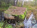 |
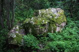
Platais Boulder (Wide boulder). You can find it in the rural municipality of Mākoņkalns not far from a
small meadow close to the boulder of Āžmugura. Both the boulders have their legends. Some say that the
boulder of Āžmugura is the part of Platais boulder and the rainwater from its cavity heals the warts.
|
|
 |
Atrodas ~ 0,4 km no Latvijas – Lietuvas robežas, Sventājas ielejas labā krasta nogāzē. Atrodama informācija, ka avotu tīrot, atklājusies 5 x 5 m ozolkoka „grīda”. Avots ir labiekārtots – virs tā slejas lapene ar niedru jumtu. Vēl pavisam nesen pie tā auga Latvijas dižākā ieva (nolūza), kuras vietā tagad kuplo biezs atvašu pulks. |
|
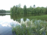 |
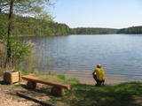
Viens no dažiem Latvijas dzidrūdens ezeriem. Apskatāms no Lubānas - Ļaudonas ceļa malas pie Visagala. Lai saudzētu šo ezeru, tajā esošos aizsargājamos biotopus un sugas, ūdenstilpē nevajadzētu peldēties lielām cilvēku masām un pieļaut cilvēka darbības produktu nonākšanu ezerā.
|
|
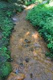 |
The Saltupju sacred stream is 1.3 km to the Northwest of the centre of Aknīste, near the small valley of the Dienvidsusēja River. The stream has been known as a source for medical treatments since antiquity. It is said that streams which flow to the East always have medicinal water, particularly on Easter morning for those who rinse their eyes in it. The water contains iron compounds, which is seen in the brown sediment (the result of iron bacteria). Alongside the stream is a stone with a small indentation, and it is thought to have been a cult stone long ago. A sacred linden tree grows at the edge of the valley. The stream can be seen with good reason as one of the most outstanding streams in all of Latvia. |
|
 |
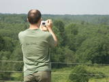
The Ķemeri National Park was established in 1997 and mostly involves wetlands – the shallow shores of the Bay of Rīga, an overgrown seaside lake, vast swamps, damp forests and fens, and flood-land meadows. The park is enormously important for protecting plants (25% of those recorded in Latvia’s Red Book are found in the park) and animals, particularly nesting and migrating birds. The Great Ķemeri Bog is one of the largest swamps in Latvia, and there are other swamps, as well – the Zaļais swamp and the Raganu swamp. The massive swamps are important, too, in the flow of sulphuric waters and medicinal mud. The once-famous Ķemeri Spa was based on the availability of these resources. Most of the cultural and historical objects in the Ķemeri National Park relate to the seashore as a place for leisure and recuperation. Educational nature trails, bicycle trails, hiking trails, bird-watching towers and other facilities are available. The visitors centre is at the recently renovated “Forest House” in Ķemeri. |
|
|
|
Linezera dabas takā apskatāms ezers, kurš mēdz pazust pazemē. Apmeklējums saskaņojams ar zemes īpašnieku. |
|
 |
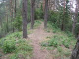
The forests of Zvārde are located on land which used to be a Soviet air base. The territory was unpopulated and was not accessible to civilians. The vast area includes various types of forest - boreal forest, bogs of black alder, etc. The fact that the military used to control the territory is one of the reasons why the forests of Zvārde are a location where many rare and protected birds live, reproduce and find food. Some of the elements of the old air base are still in place, including a unique surveillance platform. It is recommended that visitors to the area drive only along general use roads. |
|
 |
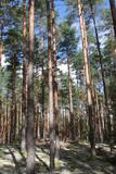
This is another so-called hill left behind by the Ice Age – five kilometres long with a height of between 15 and 30 metres and with high hillocks and steep hillsides. Te most distinct part of the hill can be found between Lake Pinti and Lake Šeški. The pine forests on the hillocks are a habitat with many rare and protected species. A trail has been established to tour Grebļa Hill, as well as Āža Hill and Kausu Hill, but it is recommended that visitors travel the trail in the company of a guide. The biological diversity of the area is made clear if one knows, for instance, that more than 500 kinds of butterflies have been found in the restricted territory.
|
|
 |
The aim of this territory is to regulate the natural and cultural landscapes of the upper reaches of the Daugava River valley, where there is a great deal of biological diversity. Nature trails have been installed in the park, as have bicycle routes. The river is good for boating in this area, too. The Curves of the Daugava nature park is part of the territory (see “Nature Parks”). |
|
|
|
One of the richest sources of sulphurous water in Latvia.
|
|
 |
Līdz akmenim aizved (ir norādes) skaista taka, kas līkumo pa Rogāļu strauta izrauto gravu. Strauta kreisā krasta nogāzē, ~ 0,1 km pirms tā ietekas Daugavā, iegūlis 6,5 m garais, 4,6 m platais un līdz 3,7 m augstais Rogāļu akmens, kura tilpums ir novērtēts ap 40 m³. Blakus tam atrodas liela atlūza. |
|
|
|
Nepilnus 3 km garā taka iepazīstina ar dziļo Imulas ieleju – Abavas kreisā krasta pieteku. Īpaši iespaidīga ieleja izskatās bezlapu periodā, kad ir apjaušami tās izmēri un formas. Viens no takas iespaidīgākajiem objektiem ir Buses jeb Matkules pilskalns. Apskatāmi citi objekti – Baznīckalns, Bedrīšakmens, Ķauķa kalns ar avotiņu. Atrodas dabas parkā „Abavas senleja”. |
|
 |
This is the highest point in the Latgale highlands (289 metres above sea level), opening up a narrow but lovely view of Lake Rāzna and the massive forests of the highlands. You really should visit this hill when the sun is setting beautifully!
|
|
 |
The barrow which offers a good view is at the northern end of the Dunduri meadows – at the end of Melnragi. It is an artificial barrow which follows along with the bed of the little Slampe River. The meadows are home to livestock allowed to live in the wild, and you can see a bit of the restored Slampe. The view is particularly interesting during flooding season, when the surrounding wetlands become saturated. This is a location for bird-watching.
|
|
 |
Dabas liegums veidots ainaviskā Kāla ezera trīs salu (Tolkas, Lielā Vestienas un Vistu sala) un to mežu biotopu aizsardzībai. Diemžēl, salu apmeklētāji (makšķernieki?) aiz sevis ir atstājuši ne tikai nelabiekārtotas apmetņu un ugunskuru vietas, bet arī atkritumus. Tā kā salu vērtību spēs novērtēt tikai zinošs speciālists, ieteicams dabas liegumu vērot no skaistajiem un pauguriem klātajiem Kāla ezera ziemeļu un austrumu krastiem. Teritorija atrodas Vestienas aizsargājamo ainavu apvidū.
|
|
 |
This is a stretched-out territory from Valmiera to the Ape Administrative District, and its primary “axis” is the unregulated Gauja River valley with a dense web of old rivers, park-like meadows of oak trees on their banks, and stands of oaks and other broadleaf trees. Many rare and protected birds, including corn-crakes, woodpeckers, wood grouses and others live and breed here. This is also one of the most important places in Latvia in terms of where the deciduous tree hermit beetle lives.
|
|
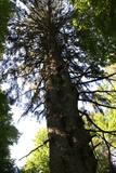 |
This is the thickest and mightiest Norwegian spruce (Picea abies) in Latvia. Its monolithic trunk, with its small holes, is unusual. The tree is in the overgrown park of the former Īve Estate, behind the ruins of the mansion.
|
|
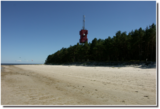 |
Cape Ragaciems – a promontory from
the western shore of the Bay of Rīga which
ends with a shallow and rocky submarine
shallows reaching several hundred metres
into the sea. The Ragaciems Lighthouse is
at the tip of the cape
|
|
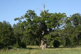 |
The tree is in the middle of an untended field. Despite many dead branches and the messy surroundings, the tree is beautiful and well visible from the road. It is the third thickest tree in the Baltic States.
|
|


