
| Нo | Название | Описание |
|---|---|---|
 |
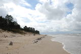
Baltijas mērogā unikāls dabas un cilvēkizmantots apvidus, kas veidojies kādreiz - padomju, mūsdienās - Latvijas Nacionālo bruņoto spēku pārvaldītā armijas poligona teritorijā. Poligona lielāko daļu aizņem smilšains vai ar zemiem lakstaugiem un krūmāju apaudzis kāpu masīvs ar atsevišķiem lielākiem kāpu vaļņiem. Rudens laikā šeit lielās platībās zied virši. Unikālā virsāju un aprimušo kāpu ainava un daudzu sugu dzīves vieta bija daži no iemesliem, kādēļ šai militārai teritorijai ir piešķirts arī aizsargājamas dabas teritorijas statuss. Jāatgādina, ka poligona apmeklējumi privātpersonām bez iepriekšēja saskaņojuma ir aizliegti!
|
|
 |
Between Saunags and Vaide on the road to Kolka, you will see an area on the left (South) side of the road where there was a massive forest fire in 1992 which burned approximately 3,300 hectares of forest. Biologists use the area to study the regeneration of the forest. There were extensive and destructive fires here during the early 20th century, as well. Swedish scientists say that there have been at least 15 fires in the forests of Šlītere over the last several centuries. The burned area is in a nature reserve and can only be viewed from the road. |
|
 |
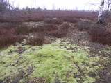
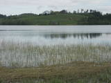
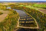
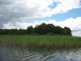
Most of this restricted area is made up of a shallow and eutrophic body of water in which many species of birds, including some that are rare and protected, nest. Specialists say that anywhere between 150 and 450 pairs of black-headed gulls nest in this area on a regular basis.
|
|
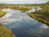 |
The Ķemeri National Park was established in 1997 and mostly involves wetlands – the shallow shores of the Bay of Rīga, an overgrown seaside lake, vast swamps, damp forests and fens, and flood-land meadows. The park is enormously important for protecting plants (25% of those recorded in Latvia’s Red Book are found in the park) and animals, particularly nesting and migrating birds. The Great Ķemeri Bog is one of the largest swamps in Latvia, and there are other swamps, as well – the Zaļais swamp and the Raganu swamp. The massive swamps are important, too, in the flow of sulphuric waters and medicinal mud. The once-famous Ķemeri Spa was based on the availability of these resources. Most of the cultural and historical objects in the Ķemeri National Park relate to the seashore as a place for leisure and recuperation. Educational nature trails, bicycle trails, hiking trails, bird-watching towers and other facilities are available. The visitors centre is at the recently renovated “Forest House” in Ķemeri. |
|
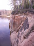 |
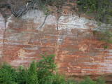
These sandstone cliffs were once known as the Pieškalni or Pieškaļi cliffs. They are around 7 km to the North from the centre of Cēsis. These are the most monolithic sandstone cliffs in the Baltic States – around 700 m long (with some 330 m along the Gauja River) and a maximum height of 22 m. There is a viewing area which offers a grand view of the Gauja River valley. Water tourists will boat up to the majestic wall of the cliff and will be surprised at what they see! The name of the cliffs, Ērģeles, is the word for "pipe organ" in Latvian, and the name was supposedly given to the cliffs because of the echoes which can be heard there – they reputedly sound like an organ. Hikers and boaters must be very careful when in this area – please make sure that you are safe! Please note, too, that the infrastructure of the cliff is scheduled to be renovated in 2012. |
|
 |
This nature park was established to protect the Burzava hillocks, Lake Adamova (a eutrophic lake), and the habitats and species that are found along the lake’s shores – bats included. The loveliest views of the area can be viewed from the hillocks that are on the northern shore of the lake. There are tourist accommodations on the shores of Lake Adamova where tourists can spend the night. |
|
 |
Яунсташульский камень чертова следа находится в деревне
Яунсташулю, в зарослях около заброшенных домов. Без знающего
человека это место трудно найти. Высота камня от земли 0,75 м,
окружность около земли 5,85 м. На его поверхности отпечатался человеческий след, длина которого
0,3 м, ширина 0,09 м, глубина 0,02. Был еще второй след, но, очевидно, откололся. В северный бок
камня как бы ударили три ступни.
|
|
 |
Казиньмежс – небольшой лесной массив на востоке от перекрестка дорог
Цирсте – Мазирбе и Колка – Вентспилс. Место преданий. Через Казиньмежс по доро-
ге Крустцельш доходим до перекрестка дороги Колка – Вентспилс (Р 124).
|
|
 |
One of the most popular areas of uncovered sandstone in Latvia, known for its unusually smooth and sound-reflecting cliff wall (around 12m in height). Located on the right bank of the Salaca river, there is a place for tenting. A fun experiment is to stand in various closes opposite the cliff and to speak quietly. The echo will be heard either by the speaker or by people who are standing elsewhere. Located in the Salaca valley nature park and the Skaņaiskalns park.
|
|
 |
Volzbahs ir stāva nogāze ar elpu aizraujošu skatu pāri gravai. Ziemā šeit pieejams vairāk nekā 100 m garš nobrauciens ar slēpēm, sniega dēli vai ragaviņām. Citos gadalaikos Volzbaha kalns ir lieliska atpūtas vieta- šeit ir labiekārtota vieta piknikam, pastaigām, foto sesijām. Rudenī Volzbaha kalns ir viena no labākajām vietām Vaiņodes novadā, kur vērot krāšņos rudens skatus. Volzbahs atrodas 2 km no Vaiņodes centra ZR virzienā. Kalnam ērti var piebraukt klāt ar automašīnām. Adrese: Vaiņodes pagasts, Dienvidkurzemes novads, LV-3435 Facebook: facebook.com/biedribavolzbahs Twitter: Volzbahs |
|
 |
Aizaudzis un purvains ezers - Ļūbasts, ar grūti pieejamiem vai nepieejamiem krastiem. Dabas vērošanai šobrīd nepiemērota vieta. Galvenās aizsargājamās vērtības - dažādas putnu sugas, t.sk. dzērves un melnie zīriņi.
|
|
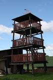 |
This is an interesting viewing tower which is part of one of the farm buildings. It offers a lovely view of the surrounding area.
|
|
 |
Бернати - самая западная точка суши Латвии. Рядом с автостоянкой установлен каменный знак скульптора Вилниса Титанса «Зеленый луч» (1998 г.). Бернатский мыс подвержен воздействию ветра и волн, поэтому здесь наблюдается вымывание морского берега. У дороги, которая из центра поселка Бернати ведет к морю, в конце дюн (имеется указатель), установлен памятный камень со словами первого Президента Латвии Яниса Чаксте, сказанными в 1924 году: «Здесь должен быть курорт». |
|
 |
Of the many islands in Lake Rušons, ten are restricted natural areas so as to protect the broadleaf forests which are on the islands and the endangered plants found therein. An ancient cult location – the Rušons Sacrificial Rock – is found on Upursala island.
|
|
 |
This area was established to protect the cultural and lake-related landscapes of the central section of the Vidzeme highlands, with Lake Alauksts, Lake Inesis, Lake Tauns, etc., with their species and biotopes. There are many important cultural objects in this territory – the Vecpiebalga Lutheran Church, the Vecpiebalga castle ruins, the Vecpiebalga baronial estate, as well as locations where several distinguished figures from the Latvian world of culture have lived and worked. Memorial museums have been established to commemorate them. The lakes are great for fishing, and cross-country competitions are traditionally held in the area of Lake Alauksts during the winter. The Sproģi nature reserve has been established on the islands and peninsula of Lake Inesis.
|
|
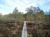 |
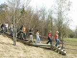
Here you can cross a swamp without getting your feet wet and enjoy the local environment, which has been little touched by humankind. You can take the dam of the former Smiltene-Valmiera-Ainaži narrow gauge railroad. It crosses the swamp from the South-East to the North-West and is three to four km in length. There is also a circular wooden pathway on the eastern side of the dam. The length of the trail (including the dam) is around 5km, and it will take 90 minutes to two hours to traverse. The area is covered by environmental restrictions.
|
|
 |
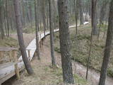
Тропа создана на склоне основного берега древней долины реки Абава, где можно осмотреть рассредоточенное выклинивание подземных вод, различные типы лугов, можжевельниковые поляны и др. На береговом склоне весь год „хозяйничают” дикие коровы. 200 ступеней приведут вас к вершине берега древней долины, с которой открывается великолепный вид. Тропу рекомендуется посещать в сопровождении местного гида. |
|
 |
Lielbātas dabīgais dzidravots ir lielākais Latvijā un viens no retajiem Ziemeļeiropā, kas zemes virspusē no dzīlēm iznes bioloģiski aktīvu un pareizi strukturētu ūdeni. Lielbātas dzidravots tek no rietumiem uz austrumiem pretī saulei, tāpēc jau izsenis tiek uzskatīts par maģisku, pat svētu, kam piemīt dziednieciskas spējas. Vēstures materiālos Lielbātas avots pirmo reizi pieminēts 1253. gadā un līdz šim brīdim turpina savu plūdumu. Lielbātas avots atrodas sakoptā un ekoloģiski tīrā vidē. Laikam ritot, avota ūdens plūsma nav mazinājusies, bet tieši pretēji, tā ir pieņēmusies spēkā un ar apbrīnojamu jaudu avots turpina dot unikālu dabas velti – tīru, bioloģiski aktīvu, pareizi strukturētu ūdeni, neapstājoties ne dienu, ne nakti, ne ziemu, ne vasaru. Netālu no avota atrodas vēsturiskā Vaiņodes jeb Lielbātas pils, kuru 19. gs. vidū būvēja barons Osten Sakens. Vēstures liecības liecina, ka šī vieta pils būvniecībai nav izvēlēta nejauši. 1923. gadā pilī tika izveidota sanatorija, kas ne tikai bija priekšzīmīgākā Latvijā, bet varēja cienīgi līdzināties ārzemju sanatorijām. Tam par iemeslu bija dabiski tīrā un dziednieciskā vide, kas saglabājusies līdz pat mūsdienām. Lielbātas pils ir privātīpašums un apmeklētājiem nav pieejama, taču Lielbātas avots ir brīvi pieejams, un katram ir iespējams nogaršot avota ūdeni. Adrese: Vaiņodes pils, Vaiņodes pagasts, Dienvidkurzemes novads LV-3535 |
|
 |
The nature park in the city of Jūrmala was set up to protect dune, pine forest and shoreline habitats. This park features one of the most attractive nature trails in the Rīga area, and it is found near the famous Ragakāpa dune, which can be as much as 17 metres high. This is an excellent opportunity to study dune habitats and the plants, birds, insects, etc., which live there. Visitors can also see pine trees that are 100 years old and older. |
|
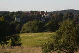 |
The hill is the highest point on the shores of the little Slocene River valley, and it is located in Tukums, at the side of Jelgavas Street. It opens up a broad view of the Slocene River valley and the town of Tukums with its historical centre on the opposite side of the valley. The view is particularly interesting in the evening, when the town is lit up. There is a monument to the liberators of Tukums.
|
|


