
| Nr | Name | Beschreibung |
|---|---|---|
 |
This is one of the most lovely and expressive castle hills in Latvia, with a very fine view of territory all the way to Lithuania. According to Ernests Brastiņš, a researcher of castle hills in Latvia, this was the site of the Semigalian Sidrabene castle. There are no improvements in the area.
|
|
 |
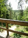
On the left bank of the Gauja River, opposite the Piķene cliff is the mighty Beite cliff which is split by a deep ravine. On the left side there is Ķeizarskats (Emperor's View), which is approximately 67 metres above the level of the Gauja and offers a fine view of Krimulda and the Turaida Castle. The viewing place was installed in 1862, when Russian Tsar Alexander II visited Sigulda. On the right side of the ravine is the mighty wooden Ķeizarkrēsls (Emperor's Chair). To get there, you have to cross the ravine (there are wooden stairs and a forest trail). You can go around it on Laurenču, Kalna and Gulbju streets. |
|
 |
Dieser Weinberg war schon in den Zeiten des Herzogtums Kurland als der Ort bekannt, wo so weit im Norden Weintrauben gezüchtet wurden. Hier werden sie immer noch gezüchtet, und aus den Weintrauben wird der säuerliche nordkurländische Wein hergestellt. Jährlich findet in Sabile in der zweiten Hälfte von Juli das Weinfest statt. |
|
 |
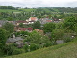
We recommend that you walk through the town of Kandava not only to enjoy the charm of a small town, but also to find fantastic viewing locations where you can see the town and the shores of the ancient Abava River valley from the Kurši (Ancestor) castle hill, Lielā Street, the Bruņinieki castle hill and Zīļu Street (School Hill), as well as from the area of the Ozolāji open-air stage.
|
|
 |
The barrow which offers a good view is at the northern end of the Dunduri meadows – at the end of Melnragi. It is an artificial barrow which follows along with the bed of the little Slampe River. The meadows are home to livestock allowed to live in the wild, and you can see a bit of the restored Slampe. The view is particularly interesting during flooding season, when the surrounding wetlands become saturated. This is a location for bird-watching.
|
|
 |
Beautiful views are accessible from the Sabile castle hill (steps, a location for relaxation), Upurkalns Hill (no improvements) and Briņķpedvāle, which part of the Pedvāle Open-Air Art Museum. There are also the Drubaži nature trails. The road between Kandava and Sabile which runs along the right bank of the Abava and the Aizdzire-Kalnmuiža road which runs on the left bank of the Abava also offer beautiful landscapes.
|
|
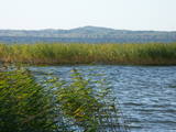 |
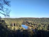
The eastern, southern and western shores of Lake Rāzna have roads which offer many lovely and unusual views of Latvia’s second largest lake and its surrounding landscape. Particularly lovely is the road between Foļvarkova and Vilkakrogs, which is part of the Rēzekne-Ezernieki road.
|
|
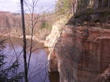 |
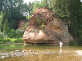
The viewing area on the Ērgļi (Ērģeles) cliffs offers an impressive view of Latvia’s most monolith sandstone cliffs (up to 22 metres high) – this is the highest location in the Gauja River valley. Please be very careful and don’t go anywhere near the edge of the cliff!
|
|
 |
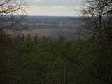
This is a view worth a journey from a distance. This is an impressive terrain for Latvia, and here you will see as far as the Hanja highlands of Estonia, where the Great Munameģis Hill – the highest surface in the Baltic States – can be found.
|
|
|
|
Viena no augstākajām Latvijas celtnēm ar vienu no augstākajiem skatu laukumiem (65 m). Paveras izcila Vecrīgas un Rīgas ainava, kā arī Daugavas (līdz Rīgas HES dambim) un Pārdaugavas skati. Labi redzami blakus esošie Rīgas centrāltirgus paviljoni. |
|
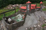 |
In diese konnte man über eine Zugbrücke gelangen, in dem man die äußere und die innere Vorburg durchquerte. Bis in die Mitte des 16. Jh. diente die Burg als Residenz des Komturs von Dünaburg. 1577 wurde sie vom Heer Iwans des Schrecklichen zerstört.Nach diesem Ereignis verlor Dünaburg seine strategische Bedeutung und der Bau eines Festungsbaus wurde dort begonnen, wo sich heute Daugavpils befindet. Neben der Ruine der Ordensburg befindet sich ein verkleinertes Modell der Burg, damit man sich vorstellen kann, wie es hier vor vielen Jahrhunderten ausgesehen hat. Vom Parkplatz bis zum Burghügel gelangt man über einen bequemen Pfad.Vom Burgberg hat man einen der schönsten Ausblicke auf den Naturpark der Daugavabiegungen. |
|
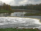 |
The recently renovated old brick bridge and the viewing area that is on the left bank of the Venta beyond the castle guard’s hut offers a lovely view of the widest and most impressive waterfall in Latvia – the Venta falls. It is worth visiting during the spring floods, when fish are migrating.
|
|
 |
One of the highest dunes in Latvia, located between Bernāti and Jūrmalciems villages. It is 37m high and offers a magnificent view of the sea and natural pine forests. The highest dunes in Latvia stand to the South of Jūrmalciems village: the Pūsēnu hill, the Ķupu hill, the Mietragkalns or Tiesas hill, the Pāļu hill, the Garais hill, the Ātrais hill, the Lāvas hill. The Pūsēnu dune is the highest of these dunes which are all called hills by the local people. The Pūsēnu hill developed between 1785 to 1835 when shifting sand became extremely dangerous. Several homesteads were buried in sand, among them „Pūsēni”, where a forester’s family lived. The family is said to have moved to Bārta. The dune was named after the buried homestead. Jēkabs Janševskis, a Latvian writer, wrote in his book „Nīca”: “In olden times, large pine trees were growing in the dunes on the coast of Nīca and they stood steady and firm. But i Swedish times (around 1650), the Swedes built a large kiln for charcoal and tar. Pine wood and stumps provided an excellent material for this. Once a big fire rose, and the charcoal kiln burned down as well as the whole pine forest. The remaining stumps and bare trunks in the vast burnout could not hold the storm-driven sand; it flew further and further burying not only the burned-out forest, but also the nearest fields. In wintertime, when the vast, low marshy grasslands were covered with ice, jets of sand drifted further over its surface, and soon most of the grasslands and large meadows turned into sandy heath-land and dunes.” To reconstruct Liepāja, severely damaged during WWII, a silicate brick factory was built in the town. The main raw material was white sand and it was taken from the Bernātu forest. In the 1960-ies they started to dig off the Green Dune and the White Dune, later also the Pūsēnu hill. The excavators used to work day and night, in three shifts. The work stopped at around 1980, as there was no more sand suitable for production of brick. A trail is set up to facilitate walking in the Pūsēnu Dune in the Bernātu Nature Park. |
|
 |
From the Markova castle hill, which you will access from the local information trial, you will see a view of the Daugavsargi curve of the Daugava. Further along, you will reach the open shore of the Daugava to see one of the most unique landscapes of Latvia’s river valleys. The Slutišķi village of Old Believers and the mighty Slutišķi cliff will be in the background.
|
|
 |
Der schönste Platz des Amata-Urstromtals mit Blick auf den Felsen, sowie auch vom Felsenabschuß (200 m lang und bis zu 44 m hoch). Am gegenüberliegenden Ufer befindet sich das Besucherzentrum. |
|
 |
Gar Grobiņas ūdenskrātuvi (Ālandes labais krasts) izveidota mūsdienīga un labiekārtota pastaigu un atpūtas vieta - promenāde, uz kuras izvietotas plāksnes ar Zentas Mauriņas un Jāņa Raiņa citātiem. No promenādes paveras labi skatu punkti uz Skābaržkalnu un Grobiņas pilsdrupām. Grobiņas ūdenskrātuves sašaurinājumā pāri Ālandei ved neliels tiltiņš, kas ir bijušā Liepājas – Aizputes šaursliežu dzelzceļa tilta ferma. |
|
 |
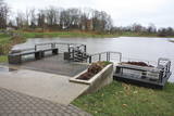
Daugavas aizsargdambju būvniecību Jēkabpilī uzsāka pēc 1981. gada lielajiem paliem, kad ūdens līmenis pārsniedza kritisko - 6,3 m atzīmi un pakāpās līdz rādījumam „8,7 metri”. Šo plūdu laikā puse pilsētas klāja Daugavas ūdeņi. 2011. gada vasarā notika plašāki dambja atjaunošanas un labiekārtošanas darbi. Pie tā uzstādīja laternas, soliņus, izveidoja pastaigu promenādi un piemiņas zīmi Daugavas kreisajā krastā, kas parāda maksimālo plūdu līmeni. Uz aizsargdambja Daugavas labajā krastā ir izvietoti informatīvie stendi, kur var uzzināt daudz interesantus faktus par pilsētas vēsturi. Dambji ir piemērota vieta, kur fotografēt vai gleznot pilsētas ainavas. |
|
 |
This is an area that is full of legend and tale. There is a stiff hillock, which stands about 66 metres above the surrounding land. From its southern side, you can see the Burtnieki lowlands. The tower, however, is not open to the public.
|
|
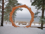 |
A new section of the walking trail along the sea has been built and an environmental object "Sunset watcher" has been created in Saulkrasti near the White Dune and Sunset Trail. It is a photo object where the newlyweds and every guest of Saulkrasti can capture memories in the symbol of the sun, which is so characteristic of Saulkrasti. |
|
 |
The Buse (Matkule) castle hill is near the Imula River. From the castle hill and from the opposite shore of the river, you can find one of the loveliest views of Kurzeme’s small rivers. Their appearance is best when trees and other flora are bare and the view is unimpeded. A wonderful view of the Imula valley is also seen on the road to the castle hill – near the Buse homestead.
|
|

