
| Нo | Название | Описание |
|---|---|---|
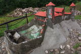 |
Науенское городище находилось на крутом правом берегу долины Даугавы на высоте 25 м, между двумя оврагами. Под руководством магистра Ливонского ордена Эрнеста фон Раценбурга в 1275 - 1277 гг. на месте прежнего латгальского деревянного замка возводится каменный замок. До середины XVI века замок служит резиденцией комтура Динабурга. В 1577 году войска Ивана Грозного полностью разрушили замок. После этого события Динабург теряет свое стратегическое значение, и строительство новых укреплений начинается в том месте, где сейчас находится Даугавпилс.Рядом с развалинами замка ордена установлен уменьшенный макет замка. С места автостоянки до городища можно дойти по тропе. С городища открывается один из красивейших видов на изгибы Даугавы. |
|
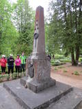 |
Находится на обочине старой дороги Алуксне – Апе, недалеко от населенного пункта Карва. Памятник был открыт 12-го ноября 1937-го года. Он создан по эскизу архитектора В. Витанда. На постаменте памятника выгравирован текст: «Воины Валмиерского полка, павшие в Борьбе за независимость Латвии в 1919-м году. На границе сложил голову, защищая свою родину». Памятник был разрушен в 1975-м году, а восстановлен в 1994-м году. |
|
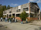 |
Один из впечатляющих бывших объектов армии СССР в Северном видземе с покинутыми зданиями, подземными бункерами, ракетными складами, с пусковыми площадками и др. элементами. Одно из тех мест в Латвии, где можно увидеть памятник Ленину. Высеченный из камня образ головы Ленина в советское время был установлен на центральной площади в Алуксне. Во времена Атмоды памятник демонтировали и перевезли на ракетно-ядерную базу. Осмотр территории следует проводить только в сопровождении гида.
|
|
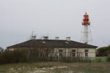 |
В советское время все маяки имели статус военных объектов, в том числе и маяк в Папе. В настоящее время маяк поддерживает Латвийская морская администрация, а осмотреть маяк можно только со стороны.
|
|
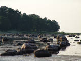 |
Береговые образования древней стадии Балтийского моря – Литоринового моря – в природе проявляются небольшим и пологим обрывистым берегом, образовавшимся примерно 4500 – 5000 лет назад. Материал береговых отложений – галька и гравий – содержат богатейший комплекс остатков фауны, характерный для Литоринового моря. Лучше всего обрыв древнего моря можно проследить возле хутора «Добели» в Калтене. Обрыв древнего берега в Калтене вляется одним из немногих участков на побережье Рижского залива, где во времена Литоринового моря был абразионный берег. Мелкие морские заливы полюбили птицы, которые здесь кормятся и отдыхают во время миграций. (Источник: Ройский ТИЦ) |
|
 |
Находится около моста через Салацу. Предлагаются блюда традиционной латышской и европейской кухни. Латышская кухня: Килька с яйцом, рыбный суп, крестьянский завтрак, жареные масляные бобы, цыплячья печень с картофельным пюре, бефстроганов по-курземски, крестьянская похлебка в горшочке, тонкие и картофельные блины с варением, слойка из черного хлеба. Особое блюдо: Открытый пирог от нашего дома. |
|
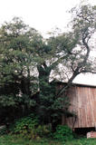 |
This is the thickest Black Alder (Alnus glutinosa) in Latvia
|
|
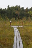 |
The small Andrupene swamp is found to the North of the Andrupene Farm Museum in a deep area between hillocks. It is a high-type swamp with an open central part, and it is 130 m long and 120 m wide. There are stands of white alder alongside the swamp. In 2009, the administrators of the Rāzna National Park restored a wooden educational pathway that had been established originally by the Andrupene Elementary School. Today there are stairs, a viewing platform, wooden pathways, and information stands. |
|
 12 дней
|
The tour combines the most beautiful southern parts of the Forest Trail in Lithuania and Latvia. The route starts in Druskininkai, Lithuania, and for the next day you will walk through forests of the Dzūkija National Park. After getting to Vilnius and Kurtuvėnai Regional Park, two sections of the Forest Trail will take you from Dengtiltis to Šaukėnai. Since it is among the most forested areas of Central Lithuania, the Kurtuvėnai Regional Park with its glaciated valleys is a wonderland of forests, waters and wetlands. The Forest Trail will run along small forest paths, tourist trails, beautiful tree alleys and wetlands. Next you will take public transportation to reach the Žemaitija National Park, where you will taketwo sections of the Forest Trail from the pilgrimage town of Žemaičių Kalvarija along the lakes of Plateliai, Ilgis and Beržoras to the town of Plateliai. It is one of the most beautiful towns of Samogitia taking pride in its manor park and the viewing platform on Lake Plateliai. Žemaitija National Park takes pride in its old pine and fir forests, as well as mixed forests. From there on the Forest Trail takes you along the riverside promenade in Kuldīga, continues through the nature park “Abavas senleja” from Renda to the wine and cider town Sabile and Kandava. The section along the Abava River Valley Nature Park is the most diverse river valley in Kurzeme in terms of landscapes and terrain. The final section of the tour takes you to the Ķemeri National Park, which is an important place for the protection of wetlands. As to the town – Ķemeri – it is the former balneological and sulphur springs resort. The tour ends on the seaside – the village of Bigauņciems, from where you can easily get to Rīga. Optionally, one can take a detour along the Lake Sloka trail with its bird-watching tower or pay a visit to the “Forest House” – the visitor’s centre of the Ķemeri National Park. |
|
 |
Моленная Речинской старообрядческой общиныпостроена в 1912 году. Четырехугольное здание
одного холла с каменным фундаментом и невысокой башенкой. Главный вход в боковой стороне
фасада.
|
|
 |
Mожно попариться в паровой бане, понаблюдать за процессом доения коров и даже поучиться этому самому, купить свежевыпеченный хлеб, булочки и уникальный яблочный чай, взять в аренду семейную палатку, поучаствовать в разных подсобных работах и научиться им, половить рыбу и искупаться в пруду, пострелять как из старинного, так и из современного лука. |
|
 |
“Saules veltes” ir mājas vīna darītava Salaspilī, kas nodarbojas ar mājas vīnu, liķieru un degvīnu gatavošanu. Alkoholiskie dzērieni tiek ražoti no dabīgiem dārza augļiem un ogām, tostarp upenēm, avenēm, cidonijām, pīlādžiem un pat mārrutkiem. Apmeklētājiem ir iespēja aplūkot saimniecību (uzņem arī 15-20 lielas tūristu grupas), kā arī degustēt konkrētos dzērienus, kurus arī turpat ir iespējams iegādāties; piedāvājumā lieli un mazi tilpumi, dāvanu un suvenīru komplekti.
|
|
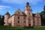 |
Во время Пилтенского епископства, в середине XIII в., был возведен замок типа конвента. Поздние пристройки замка возводились в XVI и XIX вв., создавая, таким образом, характерный для замка внутренний двор. В 30 года XIX в. фасад замка приобрел современные видимые неоготические формы. В период времени с XVI столетия до 1920 г. Эндольский замок был собственностью рода баронов Беров. После пожара в 1905 г. замок восстановили в течение двух лет. Известен историями о привидениях, о свадьбе гномов, о пятнах крови в Красной комнате замка, которые появлялись на месте убийства. Чтобы спрятать появляющиеся пятна крови, был построен камин, но пятна появлялись снова. После приватизации восстановлены интерьеры, залы, погреба, которые украшены характерными для замка элементами. Помещения замка и смотровая башня доступны для посетителей. В парке находится аллея Любви и дуб Гномов. |
|
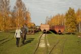 |
Sedas purva kājnieku maršruts atrodas dabas liegumā Sedas purvs, pārgājienu pa maršrutu iespējams apvienot ar Sedas pilsētas apskati, kas ir unikāls 20.gs. 50.–60. gadu pilsētbūvniecības un arhitektūras paraugs - kūdras purva strādnieku pilsēta. Maršrutam ir divi apļi - Jērcēnu aplis - 5,5 km un Sedas aplis - 4,2 km. Tajos apakatāms izstrādātais kūdras purvs, šaursliežu dzelzceļš, ritošais sastāvs, divi skatu toņi. Rudenī un pavasarī - putnu migrācijas lāikā - interesanta vieta putnu vērošanai. GPS koordinātes: Jērcēnu puses aplim: 57.7055987, 25.7001324; Sedas puses aplim: 57.6699587, 25.7514815. |
|
 |
Periodically flooded flood-land meadows on the eastern and southern shores of Lake Burtnieks are an important nesting location for the rarely seen corncrake. A nature and information trail has been established at Vīsrags with directions, information stands and a viewing tower.
|
|
 |
Ičas apmetnes ciems ir sena dzīvesvieta Ičas upes krastos. Apmetne atklāta 1937. gadā. Tā bijusi apdzīvota neolītā (4500 - 1500 pr.Kr.) un bronzas laikmetā (1500 - 500 pr.Kr.). Apmetnē dzīvojuši amatnieki, zvejnieki, mednieki.
|
|
 7 дней
|
This study tour is designed to show Latvia's rye traditions as their central focus. This tour has been developed in cooperation with the Latvian Bakers’ Association. Rye is both the basis of the Latvian diet and a powerful symbol of Latvia's culture and culinary traditions. Itinerary emphasize traditional rye bread-baking and eating, as well as insights into the history of the rye grain from Latvia's earliest archaeological record to the present day. Itinerary include visits to working farms, grain mills and culturally and historically important locations. This study tour is designed for groups and may be adapted to the needs, interests and timeframe of each client. Tour cost includes meetings with experts, site visits and admissions, accommodations, specified meals, sightseeing, transportation within Latvia and guides-interpreters. |
|
 |
Covered with rocks and with small capes and inlets, this is the eastern shore of the Bay of Rīga and the only place in Latvia where sandstone outcrops are found. These are the result of the abrasive effects of waves between Tūja and Vitrupe. Among the most distinguished of these outcrops are the Veczemi cliffs, which are less than half a kilometre long and up to four metres high. The area has been improved for tourists. It has to be said that this part of the shoreline changes very often, particularly after large storms.
|
|
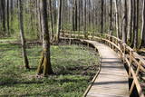 |
The excessively damp forests at this place include the Vēršupīte River bog, and this is one of the most diverse biotopes in Latvia in terms of the number of species that can be found here. The fact that the area is regularly flooded is shown by the fat roots of black alders – indeed, the place looks like a stand of mangroves. The wooden pathway that is the Dumbrāju trail starts at the Forest House for those who wish to examine the bog. The most impressive views are seen during spring floods or rainy seasons at other times of the year. The little river breaks out of its bed and floods a large territory. The Lake Sloka hiking trail is another place where you can study the Vēršupīte bog. The circular trail is 3 km long, and its beginning is at the Lake Sloka bird watching tower. |
|
 |
Glempings atrodas Amatas pagasta Dīķīšos, kur viesus sagaidīs Samojedu šķirnes suņi un inteliģenti ēzelīši, kas aizvedīs līdz glempingam dīķīša pakājē. Glempinga teltī ir lielā gulta un divguļamais dīvāns ar gultasveļu un dvieļiem, ledusskapis, svaigs ūdens, Nespresso kafijas aparāts un tējkanna, šķīvji, krūzes, glāze, ēšanas instrumenti. Ārpus telts pieejama āra duša, mazmājiņa ar ūdeni un dezinfekcijas līdzekļiem, latvju zīmēm rotāta ugunskura vieta ar iesmiem, malku un ērtiem krēsliem vakara baudīšanai, galds ar krēsliem ēšanai, bērniem smilškaste ar mantām, peldvieta. Naktsmāja ir piemērota arī cilvēkiem ratiņkrēslā, tajā skaitā ar atbilstoši izbūvētu mazmājiņu. Šis piedāvājums ir tapis sadarbībā ar sociālo uzņēmumu "Kultūras tūrisms". |
|


