
| Нo | Название | Описание |
|---|---|---|
 3 дня
|
Это один из 6 маршрутов путешествий в серии «Насладитесь деревней!», который приглашает Примерное время прохождения маршрута: четыре – пять дней, в зависимости от количества выбранных достопримечательностей и времени, отведенного для их осмотра. |
|
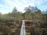 |
Here you can cross a swamp without getting your feet wet and enjoy the local environment, which has been little touched by humankind. You can take the dam of the former Smiltene-Valmiera-Ainaži narrow gauge railroad. It crosses the swamp from the South-East to the North-West and is three to four km in length. There is also a circular wooden pathway on the eastern side of the dam. The length of the trail (including the dam) is around 5km, and it will take 90 minutes to two hours to traverse. The area is covered by environmental restrictions.
|
|
 |
Историческая дорога (V1279), которая до строительства новой дороги через Эдоле соединяла Кулдигу с Алсунгой. В настоящее время живописная дорога (с гравийным покрытием) вьется через леса и сельскохозяйственные угодья. В подходящее время ее можно использовать как альтернативную дорогу, чтобы познакомиться с ландшафтами региона суйтов. По Старой дороге суйтов можно путешествовать на велосипеде. |
|
 |
В хозяйстве производят сыр и другие продукты из козьего молока. Здесь разводят коз, овец, кроликов и домашнюю птицу. Продукты можно купить по предварительному заказу, летом также организуются экскурсии по хозяйству. |
|
 |
Кафе Roomassaare находится неподалеку от Курессааре ‒ отсюда открывается живописный вид на яхтенную пристань Roomassaare. В летний сезон в кафе преимущественно готовят блюда из местных продуктов, предлагая и жителям острова, и туристам простое и чистое сочетание местных вкусов. Без рыбы не обойтись! |
|
 |
The Ungurmuiža park is well known for its outstanding and huge oak trees. Some of them are rotting or dead, and they are home to a great many species, including many that are found nowhere else in Europe. A pathway leads through these noble trees – 1.3km in length, with visitors spending as much as an hour there. The park also contains the only wooden castle from the early 18th century that has been preserved to the present day. There are other cultural and historical treasures, as well.
|
|
 |
Kihnu is the largest island in the Gulf of Riga with an area of 16.4 km2, it is only 7 km long and 3.3 km wide. There are four villages on the island and the unique atmosphere of the island can be experienced by visiting a local family at Kuraga Farm. Three generations live in this farm and are happy to welcome guests. |
|
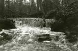 |
Here we find a set of canyon-type gullies among layers of dolomite. There are impressive outcrops and small waterfalls in the little river’s bed.
|
|
 |
Ресторан Ankur ‒ уютное место, где предлагают домашнюю еду, при приготовлении которой используются преимущественно местные продукты. Особенно ценится рыба из озера Пейпус. В одном здании с рестораном находится гостиница. |
|
 |
Karulas augstienes augstākais reljefa punkts (137 m.vjl.), kas virs tuvākās apkārtnes paceļas par ~ 60 m. Torņa kalnā ir uzbūvēts skatu tornis ar ļoti plašu apkārtskatu. Uz tā platformas ir novietoti panorāmas fotoattēli, kuros atzīmēti zīmīgākie plašākā apkaimē redzamie objekti – apdzīvotas vietas, pilskalni, baznīcu torņi u.c. Turpat izveidota atpūtas vieta un meklējams Rebases ainavu takas sākums. |
|
 |
В пейзажном стиле парк был создан во второй половине 18-го века и начале 19-го века. Инициатором создания парка был владелец Алуксненского имения барон Отто Герман фон Фитингоф. В обширном пейзажном парке можно осмотреть значимые малые архитектурные формы – павильон Александра, храм древнегреческого бога ветров Эола, Пальмовый дом, гранитный обелиск О. Г. фон Фитингофу, установленный в 1799-м году, мавзолей рода баронов, бассейн фонтана, сделанный из одного гранитного куска и гранитные скамейки. Алуксненский дворцовый парк считается одним из красивейших парков в Видземе. |
|
|
|
In Otepää wurde am 4. Juni 1884 die estnische Fahne geweiht. Im Pastorat ist ein Zimmer der estnischen Fahne eingerichtet. |
|
 |
Saimniecības zemi, kas atrodas starp Ulbroku un Vālodzēm, 1929. gadā nopirka tagadējā saimnieka – Dzintara Āboliņa vectēvs. Tajā laikā arī tika uzcelta klēts, kurā glabāja saimniecībā izaudzēto lauksaimniecības produkciju. Krīvu klēts atdzimšana notika pirms 20 gadiem, kad tagadējie saimnieki tajā uzsāka veidot muzeju no sadzīves priekšmetiem un darba instrumentiem, kas savulaik izmantoti Krīvu saimniecībā. |
|
 |
Находится в гостевом доме «Пилс» недалеко от городища Кандавских рыцарей и Пороховой башни, на которые открывается вид с летней террасы. Латышская кухня: Гороховый суп-пюре, домашний суп с фрикадельками, крем-суп из боровиков, холодный свекольный суп, жареная свинина, домашние котлеты, фаршированная камбала, картофельные блины, слойка из черного хлеба. |
|
 |
Город ветра, янтаря и музыкантов. В письменных источниках Лиепая впервые упоминается в 1253 году. Расцвет города как торгового порта начался уже в конце XVI века. Особенно знаменательным было правление Курземского герцога Екаба и Фридриха Казимира, когда через Лиепайский порт обеспечивался экспорт и импорт товаров из Литвы и Курземе. На месте засыпанной песком дюны реки Ливы был прорыт канал, создана пристань для кораблей. Рост города продолжался и в XVIII веке, после Северной войны и эпидемии чумы. Когда в 1795 году Курземе присоединили к Российской империи, Лиепайский порт стал одним из важнейших стремительно развивающихся западных портов империи. В конце XVIII – XIX вв. Лиепая одновременно становится излюбленным местом отдыха аристократии Санкт-Петербурга. В конце XIX века начались работы по возведению крепости и строительству военного порта. Город приобрел военно-стратегическое значение. Лиепая сильно пострадала во время Второй мировой войны. В 1967 году в Лиепае приостановил работу морской торговый порт, и город стал закрытым городом, где военный порт стал городом в городе. Сегодня военный порт и связанное с ним предложение является одним из востребованных продуктов туризма Латвии. |
|
 |
«Кайкайши» находятся ~ 1 км к юго-западу от центра Вецпиебалги, в небольшом поселке Кайкаши. В «Кайкаши» родился латышский писатель Антон Аустриньш (1884 – 1934). В Вецпиебалге будущий писатель получил основное образование. Одна из самых известных работ А. Аустриньша это сборник рассказов «Мальчуган» (1931). Музей, в котором представлены различные экспонаты и предметы сельского быта, связанные с жизнью писателя (также написанные сборники и книги), желательно осматривать в сопровождении местного гида. |
|
 |
Zemnieku saimniecībā "Rudzīši" iespējams apskatīt dažādus mājputnus - vistas, tītarus, dažādu šķirņu pīles un zosis. Mini zoo mīt arī cūkas, aitas un kazas. Tiek piedāvāta izjāde ar poniju, kā arī iespēja pārnakšņot brīvdienu mājā. |
|
 |
Небольшая, тихая и уютная гостиница с полюбившимся гурманам рестораном расположена на обочине Таллинского шоссе в Айнажи, где воздух пахнет соснами и морем. В уютной атмосфере ресторана можно не спеша насладиться вкусной едой и почувствовать близость природы. |
|
 |
Целью туристического центра Лахемаа является пропаганда природосберегающего образа жизни и умения жить в природе-сажаются деревья и развешиваются домики для птиц. Для интересующихся - походы на каноэ по Лахемааскому национальному парку, походы по болоту и стрельбу из лука и арбалета. Приятно провести время можно в каминном зале и сауне с гидромассажной ванной. |
|
 |
На 141 километре шоссе Риги - Екабпилс можно отдохнуть и покушать в мотеле «Сапнис». На первом этаже – кафе и зал для торжеств. |
|


