
| Нo | Название | Описание |
|---|---|---|
 |
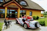
Ресторан в комплексе отдыха «Вонадзини» на берегу Лудзенского озера недалеко от города Гулбене. Предлагают вкусные рыбные, куриные и блюда из свинины. По предварительному заказу организуют обед для туристических групп, накрывают свадебные столы, банкеты и др. |
|
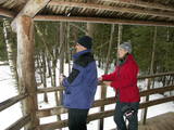 |
Lots of wild animals can be found in vast paddocks along the ancient Gauja river valley and its small tributaries – areas in which living conditions are as close to natural circumstances as possible. Here the visitor can find, if lucky, reindeer, deer, wild boars, bears, foxes, lynx, various kinds of birds, as well as aurochs. There is a dense network of pathways in the park, including lots of information. There is also a route for drivers and bicyclists. During the winter, it is used for distance skiing. There is also a visitors’ centre.
|
|
 |
Находится на берегу моря, откуда открывается всеохватывающий вид на Юрмалу. Гриль-терраса стилизована в форме корабельного штурвала. Сотрудничает с местными крестьянами и рыбакам. Латышская кухня: Холодный свекольный суп, рыбный суп, копченый угорь с деревенской сметаной, утиная печень, картофельный суп-пюре с лисичками, жареный судак, спинка оленя в горчичном соусе. |
|
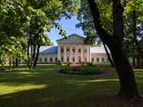 |
Усадьба Салос и ее парк расположены на острове озера Двирагис, чьи контуры с высоты птичьего полета напоминают силуэт Литвы на географической карте. В восточной части усадьбы находится парк смешанной планировки. Это один из старейших парков в Литве. Еще во времена хозяйствования Радзивиллов здесь был лесопарк с запретом на вырубку деревьев. В парке преобладали лиственные деревья местных пород: клены, липы, ясени, тополя сереющие, которым сейчас сравнялось двести лет. По берегу озера проходила тропа, соединявшая аллею с парковой дорожкой. Сегодня здесь сохранились зеленые насаждения, фрагменты аллей. |
|
 |
Taka, kas izveidota Lemmjegi (Lemmjõgi) un Raudnas (Raudna jõgi) satekas vietā, iepazīstina ar palieņu pļavām un veciem pārmitriem mežiem, kas ir vieni no lielākajiem Igaunijā. Takas sākumā dominē atklātas lauku ainavas. Viens no 4,9 km garās lokveida takas apskates objektiem ir Lemjē dižozols. Mitrā laikā noderēs ūdensizturīgi apavi. |
|
|
|
Veisieji reģionālais parks (Veisiejų regioninis parkas) veidots (1992.g.) Sudavas augstienes (Sūduvos aukštuma) ainavu, bioloģiskās daudzveidības un kultūras pieminekļu aizsardzībai. Viena no parka bagātībām ir ezeri, kuru iegarenās formas liecina par ledāja darbības rezultātu. Pēdējā apledojuma laikā šeit atradusies ledāja mala. Ezerus (kopā – 37) ieskauj lielāki meža masīvi uz kontinentālām (iekšzemes) kāpām, kas piemēroti atpūtai dabā, dabas vērošanai, ogošanai un sēņošanai. Parkā ir iekārtotas peldvietas, kur patīkami gremdēties vasaras tveicē, izveidotas dabas takas, bet mazās upītes, kas savieno ezerus, ir piemērotas braucieniem ar kanoe laivām. Veisieji reģionālā parka teritorijā ir liela augu un dzīvnieku daudzveidība. Šeit tiek aizsargātas arī tādas retas sugas kā Eiropas kokuvarde Hyla arborea (parka simbols), purva bruņurupucis Emys orbicularis, dažādas orhideju sugas u.c. |
|
 |
Уникальный объект индустриального наследия – единственный открытый завод по производству амуниции в странах Балтии, на территории которого находится самая старая дроболитейная башня в Европе, которая до сих пор используется по назначению. Группы туристов по предварительной договоренности в сопровождении гида могут осмотреть производство, дроболитейную башню и музей. Сейчас на дроболитейном заводе производят пули девяти видов для гладкоствольного оружия, а также пули для пневматического оружия. Продукция экспортируется в соседние страны, Германию и другие страны. |
|
|
|
Der weiteste Nordpunkt der Insel Hiiumaa. Der höchste Leuchtturm Estlands aus Roheisen (1873 – 1875) und das Denkmal zur Errinerung an die bei dem Unglück des Schiffes ‘Estonia” Umgekommenen. |
|
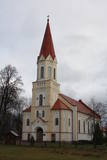 |
Храм неоднократно горел и строился снова. Теперешняя церковь построена в 1874 году, а после пожара 1927 года была восстановлена в 1932 году. Можно осмотреть алтарную икону«Иисус со святым причастием», две картины И. Зебериньша «Иисус у креста» и «Иисус благословляет детей» (1957 г.). Проспект органа является первым, построенным в «латышском» вкусе органом (резчик по дереву П. Планкус, 1936 г.), а сам инструмент номинирован как самая красивая и самая объемная работа лиепайского мастера Екаба Яугиеша. Трубы органа сделаны из дерева, что является редким случаем. Церковь можно осмотреть изнутри. |
|
 |
Atrodas dienvidos no Vienības nama. Skvērs veidots 19. gs. otrajā pusē. Tajā atrodas vairāki ievērības cienīgi objekti: strūklaka (20. gs. 20. gadi), latviešu tautas dzejnieka Andreja Pumpura krūšu tēls, piemiņas akmens Nevainīgajiem sarkanā terora upuriem un Sv. Aleksandra Ņevska pareizticīgo kapela. Vienības ielas otrā pusē paceļas iespaidīgā Daugavpils universitātes ēka ar Raiņa pieminekli un saules pulksteni priekšplānā. |
|
 |
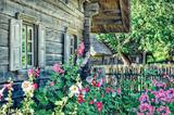
Местность, где расположена усадьба, местными называется Центром деревни Домантай. Усадьба состоит из 4-ёх отдельных зданий, сохранивших традиции этнической архитектуры: карчама, житница, баня, традиционная изба. |
|
 |
Музей деревенского быта был основан в 1991 г. на территории в 18 га, где Аукштайтийский регион представлен аутентичными усадьбами |
|
 |
On the left bank of the Gauja River, opposite the Piķene cliff is the mighty Beite cliff which is split by a deep ravine. On the left side there is Ķeizarskats (Emperor's View), which is approximately 67 metres above the level of the Gauja and offers a fine view of Krimulda and the Turaida Castle. The viewing place was installed in 1862, when Russian Tsar Alexander II visited Sigulda. On the right side of the ravine is the mighty wooden Ķeizarkrēsls (Emperor's Chair). To get there, you have to cross the ravine (there are wooden stairs and a forest trail). You can go around it on Laurenču, Kalna and Gulbju streets. |
|
 |
Augstā un purva vidusdaļā - pārejas tipa purvs, putniem nozīmīga vieta. Apmekļējumiem nav piemērota infrastruktūras trūkuma un sugu aizsardzības nolūkā. |
|
 |
Ķekavas novadā, Daugmales pagastā atrodas jauka atpūtas vieta - Lejas ezers. Ezeram var apiet apkārt, taka nav marķēta un iešana ir pa mazām meža taciņām. Slapjākā laikā taciņas vietām var būt mitras un dubļainas. Pastaiga aizņems aptuveni stundu. Pie ezera ir iekārtotas vairākas piknika vietas. |
|
 16 дней
|
This long-distance tour follows the Baltic Coastal Hiking Route from the Lithuanian coast, starting on the island of Rusnė and continuing to the Curonian Spit, running along the Baltic Sea coast to Cape Kolka and finally reaching Rīga. On this route you will hike some sections of the Baltic Coastal Hiking Route and experience the diversity of coastal landscapes: rocky beaches, steep shores, overgrown beaches, bird migration sites, vast sandy beaches. You will walk on solitary beaches with no-one in sight for several kilometres just to suddenly find yourself in lively resort towns. There are both sections of hiking and bus transfers along the route. Initially you will visit the peculiar island of Rusnė with its bird migration sites, observation towers and the delta Crossing the Lithuanian/Latvian border on foot you will stop over at the Pape Nature Park and enjoy its lighthouse, wild horses, the authentic fishermen village and local museum. The walk on lone beaches takes you to the top of the highest dune in Latvia – the Pūsēnu dune – and afterwards continues to reach the village of Bernāti. Next on the route is the windy seaside city of Liepāja, also known as the Latvian capital of rock music. Karosta is another distinctive site in Liepāja – it is the former military town and nearly every street of this part of the city has some footprints of its military heritage. Heading further, your feet will take you through the solitary beaches of Ziemupe to the village of Pāvilosta. If you are lucky, you might find some ambers washed ashore. Pāvilosta is a small charming village with a marina and some notes of smoked fish lingering in the air. Moving on, from Ventspils through Slītere National Park, through the Livonian fishermen villages to finally reach the Kolka Cape – the meeting point of the Baltic Sea and the Gulf of Riga. Also, a top site for bird watching. At the end of the tour, the Baltic Coastal Hiking Route leads to Engure Nature Park, meandering through reed trails running between the villages of Mērsrags and Engure. The tour ends in Jūrmala with its wide sandy Beaches, the bustling urban life of a resort town, impressive villas and summer cottages, and the Ragakāpa Nature Park in the resort’s neighborhood Lielupe. |
|
 |
Another area where the manifestations water-soluble lime in the earth can be found. As the lime dissolves, there are empty areas underground which eventually collapse. To the East of Skaistkalne is a leisure area where dry and full holes of various sizes can be found.
|
|
 |
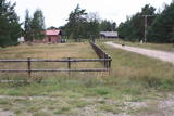
A well-kept farm and garden, rabbits and various poultry - chickens, chicks - can be viewed. |
|
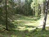 |
There are three craters here, and the biggest one, known locally as Põrguhaud, or Grave of Hell, has a diameter of 80 m and a depth of up to 12 m. There are barriers around the crater that are several metres high. The other two craters are hard to spot. The craters around 6,000 years old. No scraps of the supposed meteorite have been found, however, and so the origins of the craters cannot be confirmed with certainty.
|
|
 |
Длинное село по обе стороны реки Лужня. В 1937 году здесь было 36 домов и 2 лодочных причала. В 60-х годах 19-го века Лужня стала одним из судостроительных мест, а в годы советской оккупации поблизости находились военные базы. В 30-е годы 20-го века сюда многократно приезжали финский лингвист Лаури Кетунен и эстонский студент Оскар Лоритс, которые составили словарь ливского языка. В Лужне жил первый ливский художник Янис Белте (1893 - 1946). Двор Лужненского рыбака и земледельца «Делини» можно осмотреть в Латвийском этнографическом музее под открытым небом. |
|


