
| Нo | Название | Описание |
|---|---|---|
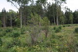 |
One of few places in Latvia (around 1 km to the North from Lapmezciems) where used to be beautiful juniper meadows. Since no agriculture activity (grass cutting, cattle grazing) has been implemented in the area, juniper meadows are overgrowing and disappearing. To save the area sustainable management is needed. Slitere National Park with Blue Mountain cliff and Slitere lighthouse is located in short distance from Kadiku nora (Juniper meadow).
|
|
 |
Small sandstone outcrops on the shores of the Ciecere River. Fish fossils have been found here.
|
|
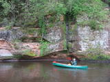 |
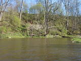
The Brasla River flows through a lovely valley that is approximately 300 m wide and up to 30 m deep. It is near the Inčukalns-Valka highway. The river has among the most beautiful rapids in the country, with mighty cliffs (the Brasla cliffs) that can be seen at nearly every curve in the river (except along the lowest reaches of the river). During the winter, various unusual frozen waterfalls can be seen in some of the cliffs, including the Krauļukalns cliff and the Jāņavārti cliff. On the left bank of the Brasla, opposite the Brasla fish farm, there are the Aņīte cliffs -- a series of sandstone cliffs that are 1 km long. The cliffs are between 2 and 35 m in height, and the sandstone cliffs are separated by ravines. On the right bank of the Brasla, there are major cliffs such as the Vāršavu cliff, the Kraukļukalns cliff, the Jāņavārti cliff, the Slūnu cliff, the Virtaka cliff and the Buļi cliff. How can you best learn about them? Boat down the river from the aforementioned highway or even from Straupe, which is further upstream. An alternative is hiking down the right bank of the river, though please take into account that the terrain is fairly extreme, and you are going to have to think about what to do when you arrive at the place where the Brasla River flows into the Gauja. |
|
 |
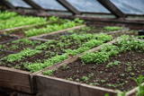
The hosts produce mixtures of dried herbs and vitamin tea in a full cycle - from seeds to a packet of spices. The farm beds and greenhouses grow a wide range of vegetables and herbs - dill, onions, garlic, chives, mint, sage, thyme, coriander, hyssop, tarragon, peppermint, chili, basil. Also used wild plants - nettle, gooseberry, viburnum, dandelion, yarrow, oregano. |
|
 |
Лустужкалнс в 16 ст. на высоком холме
(72 м н.у.м.) находился охотничий замок
магистра Ливонского ордена Вальтера фон
Плетенберга. В свою очередь, построенный
во время Русской императрицы Екатерины
дворец развлечений, от которого и пошло
название и легенда о затонувшей золотой
карете в озере Валгума.
|
|
 |
Каугурский канал вырыт в 1933 г. с
целью отвода вод рек Джуксте и Слампе в
Лиелупе для предотвращения
заболачивания
|
|
 |
В саду красивых и практичных идей великолепные посадки цветов и богатая коллекция хвойных растений радуют глаза круглый год. За домом в хозяйственной зоне находятся огород с корнеплодами и теплицы. |
|
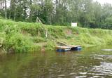 |
Atpūtas vieta Gaujas upes kreisajā krastā, pusceļā starp Virešiem un Aņņu tiltu (Gaujiena-Valka; P23). Pieejams galds maltītēm, ugunskura vieta, sausa malka, telšu vietas, tualete. |
|
 |
Находится в северо-западной части Екабпилса, на левом берегу Даугавы, напротив островка Адамсона (Крустпилс). В 19 веке этот парк был создан как место для отдыха горожан и проведения торжеств. Смело можно утверждать, что это – место мирового масштаба, так как здесь находится памятный камень, установленный в честь деятельности академика Тартусского университета, профессора – астронома и геодезиста Фридриха Георга Вильгельма Струве (1793 - 1864). Камень установлен в том месте, где Ф.Г.В. Струве закончил измерение Видземской губернии. Дуга меридиана Струве (точки дуги находятся во многих других странах Европы) включена в список мирового наследия ЮНЕСКО. |
|
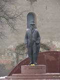 |
Opposite the tower of the Church of the Holy Trinity, the monument was designed by Arta Dumpe and commemorates Latvia’s first president, Jānis Čakste (1859-1927). It was consecrated on November 14, 2003, precisely 81 years after the statesman was elected to the important position. |
|
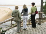 |
At the estuary of the Inčupe River, there is the White Dune, which is around 18 metres high and is the most lovely element of the Vidzeme shoreline among those that have been created by the wind, sand and sea. There is a wooden footpath (the Saulriets trail) which is meant to view, but also protect the dune. It has a viewing area, too. The territory to the south of the river is in the Piejūra Nature Park.
|
|
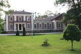 |
Atrodas Taurenē, Gaujas labajā krastā. Muižas apbūve, kurā ietilpst pils (19. gs. 80. gadi, arhitekts – R. G. Šmēlings, historisma un neoklasicisma stils), senie alus pagrabi, klēts, vecā pils un parks, veidojies 19. - 20. gs. Šobrīd muižas pilī atrodas Taurenes pagasta pārvalde un kultūras nams. Muižas kompleksā ietilpst ēka, kurā atrodas Vecpiebalgas novada tūrisma informācijas punkts un Taurenes novadpētniecības ekspozīcija (senajā ledus pagrabā). Parkā (ziemeļos no pils) uzmeklējams piemiņas akmens, kas veltīts komunistiskā terora upuriem. Pie Nēķena muižas sākās 0,4 km garā Cieres dabas taka, kas iepazīstina ar Gaujas krastu mitrājiem. |
|
 16 дней
|
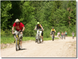
This grand hiking tour is provided for experienced hikers wishing to walk along a large part of the coasts of Latvia and Estonia, gain a detailed impression about the diverse coastal landscape, nature, birds and animals of the Baltic Sea. The Baltic Coastal Hiking Route sometimes runs through sandy beaches, sometimes along sections of beach covered in stones and pebbles. Sometimes the trail goes through coastal forests or stops at a fishermen’s village. There are many floodplain meadows, lagoons and shallow bays on the Estonian side, so sometimes the path goes along coastal trails and roads. In the end section of the route you will feel Estonia’s Nordic nature more. Part of the route runs along a sparsely populated seashore where you can be alone with yourself, but you will also be able to visit the most prominent cities. You will visit both capitals: Rīga and Tallinn. Enjoy the hospitality of the resort towns of Jūrmala, Pärnu and Haapsalu. During the hike, you will also get acquainted with the regions of small ethnic cultures: the Livonians in Latvia and the inhabitants of Kihnu in Estonia. |
|
 |
Годом основания Даугавпилса считается 1275 год. Это время, когда магистр Ливонского ордена Эрнест фон Ратцебург на Науенском городище построил Динабургский замок. Неоднократно замок выдерживал литовские и русские нападения, пока в 1577 году не был захвачен русскими войсками под командованием Ивана Грозного. После этого события Динабург был восстановлен 17-ю километрами дальше на правом берегу реки, где сегодня расположен город Даугавпилс. В период с 1810 по 1833 год была построена новая крепость. В 1826 году началась застройка тогдашнего исторического центра. В годы Первой мировой войны важные промышленные предприятия вместе с работниками были эвакуированы в Россию. Во времена первой Латвийской республики наблюдается расцвет культурной жизни Даугавпилса. Большая часть города была уничтожена во время Второй мировой войны – в июле 1944 года. Современный Даугавпилс – это второй по величине город Латвии и важный экономический центр исторического Латгальского края. Недавно началось восстановление уникальной в Европейском масштабе Даугавпилсской крепости. |
|
 |
Atrodas Vārtājas ielejas labajā krastā un labi saskatāms no Priekules – Grobiņas (P106) ceļa. Senās kuršu zemes – Piemares pilskalns, kas vēstures avotos pirmo reizi minēts 1253. gadā – līgumā starp Kurzemes bīskapu un Livonijas ordeni. Viens no lielākajiem Dienvidkurzemes pilskalniem. Iespējams, ka iepriekš – arī sens kulta kalns. Pagājušā gadsimta sešdesmitajos gados veiktajos arheoloģiskajos izrakumos konstatēts, ka pilskalns bijis apdzīvots jau vidējā dzelzs laikmetā. Pie tā konstatēta liela senspilsētas vieta. |
|
 |
В хозяйстве выращивают около 25, но готовят продукты из ~ 50 всевозможных видов растений. Экскурсантам объясняют, как лечебные растения могут использовать не только как чаи, но и в маслах, выдержках, тинктурах, сиропах и в других видах, используя их также и как ежедневные продукты питания. Предлагают дегустацию продукции, приобретение и совместные занятия. Осмотр сельских домашних животных. |
|
 |
Уютное кафе в центре Лиепаи. Кофе, вкусные пирожные, отличная еда. Каждый день – около пяти часов утра – за работу принимается мастер по приготовлению круассанов, чтобы уже в девять предложить посетителям свежую утреннюю выпечку. |
|
 |
Bejas meža dabas liegums veidots no reljefa viedokļa - interesantā, pauguru un starppauguru ieplaku saposmotā teritorijā, kuru klāj vecs un varens egļu mežs. Bejas mežā atrodas viena no Alūksnes rajonā vairākām "Velna pēdēm" - dziļa, krāterveida ieplaka, ko veidojis kūstošais ledājs.
|
|
 |
15.janvāra naktī Kalpaka bataljons izcīnīja pirmo kauju pie Lielauces, atvairot sarkano uzbrukumu. Tā bija pirmā nozīmīgā Kalpaka bataljona kauja, kad uzvara karavīriem deva īpaši spēcīgu morālu stimulu. 1934. gada 19. augustā pie Lielauces luterāņu baznīcas atklāja pelēkā granītā veidoto pieminekli Oskara Kalpaka bataljona pirmās kaujas vietā. Piemiņas zīme veidota pēc arhitekta P. Dreimaņa meta. Lielauces kauja notika 1919. gada naktī no 15. uz 16. janvāri starp kalpakiešu Cēsu un Virsnieku rotu no vienas puses un 2. strēlnieku pulka karavīriem. 50. gadu sākumā piemineklis tika iznīcināts, bet atjaunots 1991. gadā |
|
 1 день
|
This section of the Baltic Coastal Hiking Route is a comparatively short hike across a beautiful sandy beach, the coastal side of which is bounded by brightly colored pine forests with spectacular dunes and dams of dunes. To get from the beach to Carnikava, the Baltic Coastal Hiking Route will take you through a forest via a promenade. Then it takes a stroll around the Old Gauja River via a levee and reaches the pedestrian bridge over the Gauja River. Both as you start and end the hike, it is nice to sit in one of the pubs and summer cafés located on Vecāķi beach and in Carnikava. |
|


