
| Нo | Название | Описание |
|---|---|---|
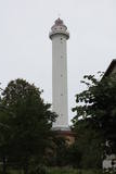 |
Данный маяк (построен в 1957 г.) является самым высоким в Латвии – 58 м. Можно осмотреть только снаружи. |
|
 |
Сад неоднократно удостаивался почетного звания самого выдающегося и образцового живописного сада Латвии. Хозяева предлагают экскурсию и советы по созданию декоративных садов. |
|
 |
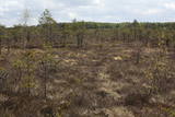
Nature restricted area is established to protect various wetland habitats – Big Kirba Bog and protected plant species within it. Only the West part of the Bog is a protected nature area. The rest of the bog is used mainly for intensive extraction of peat and large cranberry cultivation. Nature restricted area of the bog has no tourism infrastructure therefore is not useable for tourist visits.
|
|
 |
Предприятие организует природные походы, целью которых является знакомство с природой (наблюдение за тюленями, пешие, велосипедные и лыжные природные походы, на резиновых лодках по островкам национального парка Вилсанди, вылазки к орхидеям и т. д.) и культурным наследием (мыза, сельская и городская жизнь, сегодняшний день Эстонского ремесла, морское наследие). В находящемся на территории национального парка Вилсанди лесном парке Мику можно познакомиться со старинными работами в лесу и даже поучаствовать в них. |
|
 |
Ботанический сад является подразделением Шяуляйского университета. Это самый молодой и самый небольшой по площади ботанический сад в Литве. Сад был заложен в 1958 г. Его общая площадь составляет 6,54 га. |
|
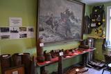 |
Музей открыли в 2007-ом году, в его небольшой экспозиции 180-мм пушка, реконструкция прибрежной полосы, убежище гражданской обороны, бронетранспортеры, пограничные катера, морские мины. В главном здании на своем первоначальном месте морской радар, экспонируются различные предметы, связанные с военной историей, обустроена часть казармы, красный уголок и оружейная комната. |
|
 |
Metāla tornis Kazari upes kreisajā krastā, ~ 5 km attālumā no Matsalu līča. No torņa redzamās Kazari deltas palieņu pļavas atrodas tikai 0,3 – 1 m augstumā virs jūras līmeņa, tādēļ pavasara palos un stipru vētru (īpaši rietumvēju) laikā ūdens appludina milzīgu teritoriju. Uzskata, ka platības ziņā šīs ir vienas no lielākajām Eiropas palieņu pļavām, kas ir nozīmīga dažādu tārtiņveidīgo putnu sugu ligzdošanas, dzērvju un zosveidīgo putnu atpūtas un barošanās vieta. Ir pagājis laiks, kad zemnieki Matsalu pļavās ganīja govis un pļāva sienu, tādēļ šobrīd pļavu apsaimniekošanu veic nacionālā parka administrācija. |
|
 2 дня
|
This part of the Forest Trail passes through the historical centre of Valmiera. In Valmiera you can visit St. Simon’s Church, the Ruins of the Livonian Order Castle and Valmiera Museum. We also suggest walking the barefoot trail in “Sajūtu Parks” (Park of Senses). After sightseeing in Valmiera, the Forest Trail goes through Atpūtas (Recreation) park, the beautiful pine forest and Baiļi winter ski centre. Further on you will walk along the River Abuls Trail, curving along the banks of the river until reaching the Brenguļi brewery built in an old Hydroelectric power plant. You can enjoy unfiltered and unpasteurised beer here. Further down you will enter unpopulated forest areas and the Northern Gauja protected landscape area. The forests in Northern Gauja (“Ziemeļgauja”) are very diverse. There are old or natural boreal (northern) forests and marsh forests, oak forests, alluvial forests (formed on river sediments which periodically flood) and mixed oak, wych elm and ash forests along the river. The tour will end in Strenči Town. |
|
 2 дня
|
The Forest Trail follows small roads and trails through the woods. Along the route you will see the Ērģeļu Cliffs, where the observation terrace provides a great view of the impressive 700 m wide sandstone cliff and the beautiful natural landscape in the ancient River Gauja valley. One of the most beautiful places on the banks of the River Gauja is at “Caunītes” tourist lodging, where you will end the first day of the route. Further on the trail leads through pine forests and wetlands, across and around hills and slopes. One of the most beautiful views of the River Gauja opens from Sietiņiezis Rock, a 15 m high sandstone cliff where a circular 1.5 km trail has been constructed. Coming to Valmiera, you will reach the so-called “Dzelzītis” bridge (a narrow-gauge railway bridge) and continue walking along the River Gauja to Valmiera Centre. Sites of interest in Valmiera: St. Simon’s Church, ruins of the Livonian Castle and Valmiera Museum. There is also an adventure park “Sajūtu Parks” (“Park of Senses”), where you can walk on the barefoot trail, the tree-top trail and enjoy other activities. |
|
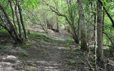 |
4 km garā un marķētā taka iepazīstina ar dziļo Imulas ieleju – Abavas kreisā krasta pieteku. Īpaši iespaidīga ieleja izskatās bezlapu periodā, kad ir apjaušami tās izmēri un formas. Vēstures cienītāji var upes gultnē uzmeklēt Langsēdes Velna pēdas akmeni. Atrodas dabas parkā „Abavas senleja”. |
|
 |
Atrodas Tērvetē, Dobeles – Elejas ceļa malā, 0,2 km dienvidrietumos no Tērvetes pilskalna. Ar mežu apaugušais paugurs ir sena apmetnes vieta, kas bijusi apdzīvota jau 1. g.t. pr. Kr. Teika stāsta, ka kalnā bijis klosteris, kura mūki pēc klusēšanas pārkāpuma saulgriežu laikā kopā ar visu celtni nogrimuši kalna dzīlēs. |
|
|
|
This is Latvia’s largest lake island and is found in the middle of Lake Usma. The island is restricted to protect old stands of pine, as well as various plants and birds. |
|
 |
Territory established mainly for protection of bog myrtle and various bird species. An interesting fact is that bog myrtle or sweet gale is used as ingredient for making famous Riga Black Balsam. Brienamais purvs (wade bog) is hard to find and reach therefore it is not suitable for tourism.
|
|
|
|
No 28 m augstā torņa, kas atrodas uz apdzīvotas „salas” – Siksalas Teiču purva vidū, paveras ļoti plaša augstā purva ainava ar Siksalas ezeru, citām minerālzemes salām un Siksalas mazciemu. Tā kā tornis atrodas Teiču dabas rezervātā, to var apmeklēt tikai Dabas aizsardzības pārvaldes inspektora pavadībā, iepriekš piesakot vizīti T: + 371 28333415. |
|
 |
Ложметейкалнс в Тирельпурве является историческим памятником государственного значения – единственный культурно-исторический заказник в Латвии (парк памяти Рождественских боев). Стоит подняться на восстановленную смотровую башню, откуда открывается вид на Мазтирельское болото с бывшей старой узкоколейкой, пересекающей болото в северо-южном направлении (в природе обозначенную как самый большой деревянный ряд в болоте). В окрестностях домов Ложметейкалнса, Тирельпурва и Мангали сохранились уникальные свидетельства Балтийского масштаба о фортификационных сооружениях Первой мировой войны и проходивших в этих местах Рождественских боях. В Мангали можно осмотреть посвященную боям экспозицию, так называемые немецкие валы и др. С территорией знакомят опытные гиды. Кроме того, в парке проходят тематические и познавательные мероприятия.
|
|
 |
The Staburags cliff of Rauna has been Latvia’s most distinct travertine cliff since the great Staburags cliff of the Daugava River sank under the waves during the construction of a hydroelectric power plant nearby. The cliff is approximately 8,000 years old and is still being formed as lime settles on moss and other plants. The Staburags cliff of Rauna is cited as the only location in Latvia of the Alpine butterwort, but it has not been seen there for the last 15 years. That is probably because of the many people who tramp across the cliff each year. The streams which deliver lime to the cliff are a biotope that is of priority at the EU level.
|
|
 |
Der dritgrößte Feldstein im Baltikum (584 m3, 7 m hoch, Durchmesser bei dem Grund – 32 m ). Auf estnisch bedeutet „Hausstein”. Befindet sich am Rande des Pikanõmme – Majakivi Pfades (4,5 km lang). |
|
 |
On the right bank of the River Pēterupe is one of the historical areas of Saulkrasti – Pēterupe Village. It is believed that the village began to form around a chapel during the so-called Swedish or Catholic times. The chapel was named after the Apostle St. Peter, and therefore the river and the village also carries his name. Pēterupe Village can be considered the oldest village in the Saulkrasti region. The oldest witnesses of the origin of Pēterupe Village are: Rectory, Pēterupe Evangelical Lutheran Church, Outpatient Clinic and the wooden buildings in the old village centre. |
|
 |
Один из главных остановочных пунктов на Северокурземском побережье, где можно получить обширную информацию и представление об истории края и побережья, культурно-исторических ценностях, строительстве парусников, традициях рыболовства, людях этого края, их труде и заслугах. Музей в Рое был основан в 1968-м году. В настоящее время можно осмотреть постоянные экспозиции о Кришьяне Валдемаре, мореходной школе в Рое и строительстве парусников в 19-м веке. Создана также экспозиция об истории рыбообработки с 19-го века до наших дней, Ливском береге, о советском вкладе в развитие побережья. Кроме осмотра основной экспозиции еще можно «познакомиться» с тремя жительницами Курземе, представляющих различные исторические периоды: Милдочка – простая жена рыбака c побережья, госпожа Паулиня со времен парусников и Анна Петровна с советского времени. Они увлекательно знакомят с предметами, не представленными в музее и со «скверным» юмором жителей Курземе. (Источник: Ройский ТИЦ) |
|
|
|
Pamatīgs trīsstāvu koka tornis, no kura atklājas viens no labākajiem Matsalu līča un tā apkaimes palieņu pļavu skatiem, kuras apsaimnieko mājlopi, veidodami piemērotu vidi dažādām putnu un augu sugām. Laba migrējošo zosveidīgo putnu vērošanas vieta. Tā kā tornis ietilpst Tūlingu (Tuulingu) saimniecības teritorijā – spēkrats ir jāatstāj netālu esošajā autostāvlaukumā, bet suņi jāved piesieti kakla siksnā. |
|


