
| Nr | Name | Beschreibung |
|---|---|---|
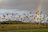 |
Der Nationalpark Matsalu (48 610 ha) wurde als Schutzgebiet für die zahlreichen Vogelarten eingerichtet. Im 1976 wurde Matsalu zu der bedeutendsten Feuchtgebiete der Welt aufgenommen und auf die Ramsar Liste eingetragen. Matsalu ein wichtiger Zwischenstopp für Zugvögel und ein Nistplatz für viele Watvögel und gehört zu den populärsten Vogelbeobachtungsgebieten in Europa. Hier gibt es viele Naturpfade und 8 Vogelbeobachtungstürme. Vogelbeobachtungstouren und Pauschalen für Familien, sowie Kanuwanderungen in Matsalu bietet der Reiseveranstalter Estonian Nature Tours (www.naturetours.ee). |
|
 |
This homestead on the banks of the Rauna River breeds various kinds of fish. During the winter, you can fish for various salmon-type fish, and in the summer you can fish for sturgeon, blue-char, tilapia and trout. You can purchase fish, and tastings are available for groups of visitors. Sillakas is approximately 3 km from Liepasmuiža. |
|
 |
In der Zeit der Sowjetunion wurden in der Nähe vom Flughafen Liepāja in Cimdenieki die Radiolokatoren für die Flugabwehr aufgestellt. Heutzutage sind die Radiolokatoren demontiert und im Platz, wo sie waren, sind nur zwei interessante künstlich gebildete Reliefformen erhalten geblieben.
|
|
 |
Briežuciems, kas atrodas Balvu novadā, ir izveidojies pēc 2. Pasaules kara kā padomju saimniecības „Briežuciems” centrālais ciemats. Mūsdienās Briežuciema amatu meistaru ciems ir vieta, kur tiek kopti un godāti tradicionālie amati, iesaistot tos mūsdienu dzīvē. |
|
 12 Tagen
|
Diese Tour bietet auch einige authentische Erfahrungen in der Region der Blauen Seen in Ostlettland und Ostlitauen. Diese Region kennt noch kein Massentourismus, hier können Sie sehr freundliche und herzliche Menschen treffen, traditionelle Dörfer, viele Kirchen und Kultstätten besichtigen, die Heidentum, römischen Katholizismus, Luthertum, russisch orthodoxen Glauben und Altgläubige zusammenbringen. |
|
 |
Pareizticība Traķu apkārtnē „ienāca” jau Lietuvas dižkunigaiša Ģedimina (Gediminas) valdīšanas laikā (1316. – 1341.). Līdz 18. gs. beigām no astoņām pareizticīgo baznīcām Traķos nebija saglabājusies neviena, tādēļ pareizticīgo draudze 1863. g. uzcēla jaunu baznīcu, kas saglabājusies līdz mūsdienām un apskatāma Vitauta ielā (Vytauto gatve) 32. |
|
 |
Nacionālā parka galvenā ainavas dominante. Ezers ir ~ 8,4 km garš un līdz 3,3 km plats. Tā austrumu krasti pārsvarā ir ar mežiem apauguši, ziemeļrietumu krasts – purvains, bet rietumu krastā parādās apdzīvotas sētas un simpātiskā Plateļu (Plateliai) pilsētiņa, kur meklējamas skaistākās skatu vietas. Ezera krastos ir labi attīstīta infrastruktūra - tūristu mītnes, ēdināšanas uzņēmumi (Plateļos), ūdenssporta un atpūtas inventāra noma. Ūdens dzidruma dēļ, Plateļu ezeru ir iecienījuši zemūdens niršanas entuziasti. Ezerā ir vairākas salas, no kurām interesanta ir Pils salas (Pilies sala), uz kuras no 15. – 16. gs. atradās muiža. Pastāv uzskats, ka senie Plateļu apkārtnes iedzīvotāji sākotnēji ir dzīvojuši uz salas, kuru ar krastu savienojis uz pāļiem celts tilts. Jāpiemin, ka 15 gs. pirmoreiz pieminētā Plateļu pilsētiņa atradusies uz Šventorkalņa (Šventorkalnis) kalna. Apkārt Plateļu ezeram ir izveidots ~ 24 km garš velomaršruts. Tā ir ļoti laba iespēja iepazīt parku videi un ceļotāja veselībai draudzīgā veidā. |
|
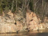 |
Boaters along the Gauja will see the Velnala cliffs, which are the last mighty wall along the banks of the Gauja River valley – approximately 15 m high. From the opposite shore of the river, where there are leisure facilities, once can spot the Krimulda Devil’s cave, which is in the centre of the cliff, is some 19 m deep, and is 4.7 m high. There were once wooden structures which allowed people to visit the cave, but that stopped in 1980 for safety reasons. If you head toward Turaida along the lower part of the basic Gauja River shoreline from the Velnala cliffs, then, particularly when the trees are bare, you will see the mighty sandstone Piķene cliff. At its foot is the Piķene beaver trail, which is approximately 1 km long. On quiet evenings, you may well spot a beaver at work. Along the path you will see the Small Devil’s cave (5 m deep) with the Wisdom Stream that flows out of it. The Aunapiere cave is almost as deep. Between the cliff and the Gauja are several small rivulets which are of enormous importance in preserving the diversity of the surrounding environment. |
|
 |
One of the highest dunes in Latvia, located between Bernāti and Jūrmalciems villages. It is 37m high and offers a magnificent view of the sea and natural pine forests. The highest dunes in Latvia stand to the South of Jūrmalciems village: the Pūsēnu hill, the Ķupu hill, the Mietragkalns or Tiesas hill, the Pāļu hill, the Garais hill, the Ātrais hill, the Lāvas hill. The Pūsēnu dune is the highest of these dunes which are all called hills by the local people. The Pūsēnu hill developed between 1785 to 1835 when shifting sand became extremely dangerous. Several homesteads were buried in sand, among them „Pūsēni”, where a forester’s family lived. The family is said to have moved to Bārta. The dune was named after the buried homestead. Jēkabs Janševskis, a Latvian writer, wrote in his book „Nīca”: “In olden times, large pine trees were growing in the dunes on the coast of Nīca and they stood steady and firm. But i Swedish times (around 1650), the Swedes built a large kiln for charcoal and tar. Pine wood and stumps provided an excellent material for this. Once a big fire rose, and the charcoal kiln burned down as well as the whole pine forest. The remaining stumps and bare trunks in the vast burnout could not hold the storm-driven sand; it flew further and further burying not only the burned-out forest, but also the nearest fields. In wintertime, when the vast, low marshy grasslands were covered with ice, jets of sand drifted further over its surface, and soon most of the grasslands and large meadows turned into sandy heath-land and dunes.” To reconstruct Liepāja, severely damaged during WWII, a silicate brick factory was built in the town. The main raw material was white sand and it was taken from the Bernātu forest. In the 1960-ies they started to dig off the Green Dune and the White Dune, later also the Pūsēnu hill. The excavators used to work day and night, in three shifts. The work stopped at around 1980, as there was no more sand suitable for production of brick. A trail is set up to facilitate walking in the Pūsēnu Dune in the Bernātu Nature Park. |
|
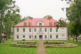 |
Das neu restaurierte Gutshaus, das von einem schönen Park umgeben ist und im Stile der Mitte des 19. Jh. daherkommt, befindet sich 14 km südlich von Panevėžys. Das Gutsensemble Bistrampolis besteht aus Gebäuden, die ab der zweiten Hälfte des 19. Jh. bis zu Beginn des 20. Jh. errichtet wurden: zweistöckiges Herrenhaus im klassizistischen Stil (Mitte 19. Jh.), Marstall, Eiskeller, Gärtnerhaus, Wirtschaftsgebäude. Das Gut ist von einem in der zweiten Hälfte des 19. Jh. angelegten Park im gemischten Stil mit Teichen umgeben. Im Gutspark ist der Pavillon auf dem Birutė-Hügel unweit des Gartenhauses ein besonderes Prunkstück. Der Park wird weiterhin belebt durch die neu gepflasterten Wege und die Brücken über die Teiche. |
|
 |
Jaunpils ūdensdzirnavas ir industriālā tūrisma apskates objekts, kurā ir saglabājusies dzirnavu iekārta, kas darbojusies 20. gs. 20.−30. gados, kā arī hidrotehniskās būves un ūdenskrātuve. Šobrīd dzirnavās ir izveidota ekspozīcija par pašām dzirnavām, malšanas procesu un graudkopību. |
|
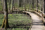 |
Uz pāļiem veidotā koku laipu taka līkumo cauri Vēršupītes dumbrājiem (pārmitri platlapju meži), tādēļ visiespaidīgākie skati šeit ir vērojami tieši pavasara palos vai citos gadalaikos pēc lielām lietavām, kad mazā upīte iziet no krastiem un appludina dumbrājus lielākā platībā. Par teritorijas sezonālu applūšanu liecina arī daudzo alkšņu resnie sakņu kakli, kas nevilšus atgādina mangrovju audzes. Mitrie meži ir viens no sugu skaita ziņā daudzveidīgākajiem Latvijas biotopiem.
|
|
 |
Vecauces ev. lut. baznīca ir valsts nozīmes arhitektūras piemineklis. Baznīca pirmo reizi uzcelta kā koka būve 1667. gadā, bet pēc zibens spēriena 1729. gadā tā nodega. Mūra baznīca celta 1744. gadā, savukārt 1866.gadā Mēdemu valdīšanas laikā baznīcu paplašināja līdz 500 sēdvietām, izgatavoja jaunu altāri, kanceli un uzstādīja Liepājas ērģeļmeistara Kārļa Hermaņa būvētas ērģeles. meklētājiem piedāvā doties interesantā, izklaidējošā un informatīvā ekskursijā pa baznīcu, apskatot ekspozīciju "Auce pirmās Latvijas brīvvalsts laikā" un baznīcas bibliotēku (Baznīcas grāmatas (pirmās Latvijas brīvvalsts laiks – 1918.-40.g., vācu laiks, padomju laiks un šodiena)). Baznīcā izveidotajā Mākslas telpā apskatei tiek piedāvātas vairākas unikālas ekspozīcijas: skolotājas Jadvigas Kupčes grāmatu un personīgo lietu ekspozīcija, kantātes “Dievs Tava zeme deg” vārdu autora Andreja Eglīša ekspozīcija, izcilā flamenko ģitārista Andreja Kārkliņa un režisora Kārļa Pamšes ekspozīcijas. |
|
 |
The cafe Baravika is situated in the centre of Rezekne city. It offers a wide variety of dishes. Working hours: Mon-Fri 8.30 līdz 18.00 |
|
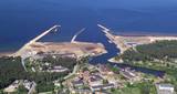 |
In the 19th century at the seaside of Skulte, a small village formed, which was inhabited by fishermen. The name “Zvejniekciems” (Fishermen’s village) arose from the population's main activity. In 1967 the Skulte part of Zvejniekciems was added to the Saulkrasti township. Nowadays Zvejniekciems is the home of Skulte Port, and the rocky beach of Zvejniekciems is located between the port and Saulkrasti Beach, while the village itself can be proud of the creative heritage left by the architect Marta Staņa (1913–1972). |
|
 |
Ein weites Territorium im Süden von Pāvilosta, wo die ehemaligen vereinten Lagerhäuser und Erdölstationen gelegen sind. Zur Zeit wird das Territorium als Gewinnungsplatz der Baustoffe und Werkstatt der Holzbearbeitung genutzt. In der Nähe des Territoriums sind Warnungszeichen "Gefährlich, lebensgefährlich!" aufgestellt.
|
|
 |
Der Bauernhof befindet sich in der Nähe von Sangaste rukkiküla mitten in der unberührten Natur. Auf dem Bauernhof können Sie leckeres Essen kosten, Fisch angeln, saunieren sowie übernachten. Sowohl Liebhaber der aktiven Erholung als auch einfache Genießer werden geeignete Aktivitäten für sich finden. |
|
 |
The central part of the town of Krāslava is an historical monument because its low-story and beautiful wooden buildings. The best views of the historical centre relate to the carp park near the Adamova trail, the Karņicskis hill, the bridge across the Daugava (Prospekta Street), and the Priedaine viewing tower on the left bank of the Daugava River. |
|
 4 Tagen
|
Маршрут ведет вдоль обоих берегов судьбоносной реки латышей – Даугавы. В маршрут включены такие значимые места, как развалины Кокнесского замка и создаваемый «Сад Судьбы». Путешественников порадуют как чудесные виды на речные ландшафты, так и древние городища, латгальские гончарные традиции и другие мастера ремесел. Даугавпилс с предложением многообразного военно-индустриального наследия и художественным центром знаменитого художника Марка Ротко. Информация о маршруте от Latvijas Lauku forums |
|
 3 Tagen
|
Von Riga führt die Tour zu der estnischen Küste mit einem Kurort und weiter mit einer Fähre zu der Insel Muhu. Auf dem Weg liegt das ethnographische Dorf Koguva, die Liiva Kirche und das elegante Landgut Padaste. Übernachtung auf der Insel Muhu, wo auch eine 28 km lange Fahrt mit dem Rad auf den Wacholdergebieten, durch die kleinen Fischerdörfer und an den herrlichen Juigu Felsen unternommen wird, aus denen sich eine Aussicht auf anderen kleinen Inseln in dem Monzunda Archipel bietet. Weiter fahren Sie zu der Insel Saaremaa und bleiben in deren Hauptstadt Kuressaare. Auf dem Weg können Sie den Meteoritenkrater Kaali, die Kirche und den Burgberg von Valjala, den Felsen Piretikivi und die Kirche von Poide besichtigen. Fahren Sie mit dem Rad bis zu 30 km auf der Halbinsel Tagameisa. Fahren Sie bis zu der Fähre und machen Sie eine Rundfahrt, indem Sie den Nationalpark Viidumae, wo Sie auf einen Aussichtssturm steigen können, die Kirche von Kihelkonna, die Quellen und den Naturpfad von Odaletsi und den Dolomitenfelsen Panga besuchen. |
|


