
| Nr | Name | Beschreibung |
|---|---|---|
 |
Getliņu ekoloģiskais poligons ir Latvijā unikāls piemērs ekoloģiski saderīgu darbības virzienu ieviešanai. Tā energobloka saražotais siltums tiek izmantots siltumnīcu apsildei, kas nodrošina ideālu vidi lauksaimnieciskai ražošanai (puķes un tomāti - lielaugļu tomāti, tumšsarkanie tomāti, aveņkrāsas ķekartomāti) gada aukstajos mēnešos. Poligona teritoriju (zālāju) nogana ar aitu ganāmpulka palīdzību. |
|
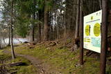 |
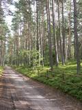
Takas sākums atrodas pie Veclaicenes pagasta pārvaldes (autosvālaukums). Tā izlokas gar Ievas, Trumulīša un Raipala ezeru dienvidu krastiem un pa ziemeļu krastu nogāzēm atgriežas atpakaļ sākumpunktā. Apļveida takas garums – ap 8 km. Atrodas Augšzemes aizsargājamo ainavu apvidū, Kornetu – Peļļu subglaciālajā vagā. |
|
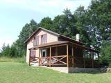 |
Atrodas ezera krastā, netālu mežs. Vieta kā radīta, lai paceptu gaļu, pamētātu bumbu grozā, pasauļotos vai pašūpotos šūpolēs. Tiem, kam patīk nakņot teltī, ezera krastā izveidotas 3 atsevišķas vietas teltīm mierīgai atpūtai. Ugunskura vieta, tiltiņš pāri ezeram, elektrība. Makšķerēšana, ogošana, sēņošana, vēžošana. Aktivitātēm brīvā dabā - bērnu rotaļu laukums, laivas, ūdens velosipēds, siltuma mīļotājiem - pirts. Laipni gaidīti arī ziemā uz slēpošanu un slidošanu. Atgriežoties no āra, gaidīs silta mājiņa un kamīnā kursies uguns. Saimniecībā ir bites, tāpēc medu varēsiet nobaudīt pa taisno no stropa medus kārē. Pieejams "stropa" namiņš, kurš speciāli aprīkota ar bišu stropu klimatu, lai sajustu tā pozitīvo ietekmi uz ķermeni un garu! |
|
 |
The farm "Kronīši" is located in Viļķenes Parish, Limbažu County. The farm grows organic vegetables that are processed into various home preserves. Teas are produced from plants collected from organic meadows, jams, preserves, syrups and juices are also on offer. Fruits and berries are collected from the garden itself, as well as from local farmers and the nearby Rūstuži and Blome marshes. The farm welcomes tourists and exchange groups with prior application. For family events, incl. a teahouse is available for children's parties, creative workshops and other activities. Offers tours with Soviet-era cars and retro cars. |
|
 |
The smithy produces fencing, gates, wind gauges, chandeliers, household products and souvenirs. The craftsman will be happy to tell you about his work and to demonstrate his skills. |
|
 |
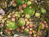
Saimniecība specializējas uz dažādu dekoratīvo stādu audzēšanu nelielos apjopmos. Sezonas laikā pieejamas arī svaigas krūmmellenes, smiltsērkšķi, cidonijas, augļi un ogas. |
|
 2 Tagen
|
Diese Tour gibt Ihnen einen Eindruck vom östlichen Teil Lettlands, der weniger bevölkert und auch bei Touristen weniger beliebt ist. Sie werden zuerst in Aluksne ankommen und die Stadt erkunden, die sich im Hochland von Alūksne am Ufer des Alūksne-Sees befindet. Es lohnt sich, Temple Hill zu besuchen - einen alten lettischen Burghügel und den Ort der Altstadt, der Sonnenbrücke, des Schloss-Herrenhausparks, der Alūksne Lutheran Church und des Bibelmuseums. Nachdem Sie dort übernachtet haben, fahren Sie mit dem Bus zum Startpunkt der Wanderung in Ape. Dieser Waldwegabschnitt schlängelt sich durch eine hügelige Ackerlandschaft und mündet dann in einen großen dunklen Wald, der gelegentlich von den blauen Oberflächen der Seen unterbrochen wird. Nach Peļļi überquert es die lettisch-estnische Grenze und windet sich 2 km lang an den Ufern der Seen Smilšājs, Sūneklis und Ilgājs auf der estnischen Seite, bekannt als Paganamaa (Übersetzung: Teufelsland). Dort steigt es ab und tritt in die subglaziale Depression Korneti-Peļļi ein, eine der beeindruckendsten Schluchten Lettlands. Der Waldweg kehrt am Ilgājs-See nach Lettland zurück und führt Sie nach einem steilen Aufstieg durch ein hügeliges Gebiet zum Burghügel von Drusku. Hier können Sie eine schöne Aussicht genießen. Am Ende dieser Tour erreichen Sie Korneti. Der Abschnitt befindet sich im geschützten Landschaftsgebiet „Veclaicene“. |
|
 2 Tagen
|
Die Region Zemgale liegt auf einem fruchtbaren Boden. In der Region gibt es zahlreiche moderne Bauernhöfe. Darunter sind auch solche, die Besuchern die schönsten Seiten des Landlebens zeigen und das von Generation zu Generation weitervererbte landwirtschaftliche Wissen vermitteln. |
|
 |
Ein bedeutender Ort der lettischen Geschichte, denn hier befand sich im 12. und 13. Jh. das amtliche und auch kulturelle Zentrum des alten lettgalischen Landes Jersika mit der Burg des Herrschers Visvaldis am 18m hohen Ufer der Daugava, wo sich der mächtige Burghügel erhebt. |
|
 |
Šūpošanās ir veselīga nodarbošanās, šūpoles ir enerģijas uzkrāšanas avots. Kad dabā veidojas spēcīgs enerģijas maksimums, šūpojoties iespējams saņemt īpaši daudz. Šūpoles ļauj atrauties no zemes, kaut uz mirkli. Parka teritorijā ir brīvdabas pavarda vieta un pirts. Saimniece piedāvā profesionālus pirts rituālus un nakšņošanas iespējas. |
|
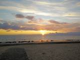 |
Als die größte Ortschaft begann sich Saulkrasti am Ende des 19. Jahrhunderts zu bilden, wenn kleine Fischerdörfer – Neibāde, Pēterupe und Katrīnbāde zum populären Erholungs- und Badeort der Rigenser wurden. Das hat sich rasch den Bau der Sommerhäuser beigetragen. Auf die Entwicklung des Kurorts hat sich auch den 1905 eröffneten Schiffsverkehr zwischen Rīga und Saulkrasti ausgewirkt. Es wurden neue Kurhäuser, Restaurants gebaut und eine andere mit dem Kurort verbundene Infrastruktur entwickelt. Zur Verfügung der Besucher standen in der Sommerzeit verschiedene Veranstaltungen, Bälle und Konzerte mit dem Teilnahme der Orchester aus Rīga. Die nächste Etappe der Entwicklung des Kurorts waren eine in den 30er Jahren des 20. Jahrhunderts gebaute Automobilstraße und eine Eisenbahnlinie zwischen Rīga und Saulkrasti. In der Sowjetzeit wurden Erholungshäuser, Sanatorien und neue Sommerhäuschen gebaut. Saulkrasti wird eine Stadt. Heutzutage lockt die Stadt Saulkrasti nicht nur durch den weißen Sandstrand, sonder auch durch verschiedene jährliche gesellschaftliche Veranstaltungen, den Pfad des Sonnenuntergangs und die Weiße Düne, das einzigartige Fahrradmuseum von Saulkrasti, den Meerespark und die Badestelle „Centrs”, den Saules Platz u.a. Objekte an. |
|
 |
Established: 1959
60 coniferous and 350 deciduous trees
Brief description: Between the Tukums-Kolka road, the Lāčupīte stream and the sea, Igors Mednis has planted a series of foreign trees and shrubs. He has conducted experiments to see how different foreign plants adapt to different conditions. The best time to visit is in May and June, when the rhododendrons are in bloom.
|
|
 |
The Boulder of Purmaļi is the biggest boulder in Rēzekne district and one of the 20 biggest boulders in
Latvia. It is located on the escarpment surrounded by the trees and the bushes. Perimeter 18,5 m, height 3,2 m,
lenght 5,6 m, width 4,7, surface volume 30 m3.
|
|
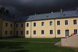 |
The origins of the castle date back to 1237. The closed yard that was typical of Medieval castles has been preserved. The interior took on its Historicism design in the mid-19th century, but there are also more ancient elements such as the gate tower, the basic walls, the firing apertures, the vaulted structures, the window apertures, etc. The Jēkabpils Museum of History was installed in the castle in 1994, and it can be toured in the company of a guide or an audio guide. |
|
 |
Alises Zariņas bioloģiskā saimniecība nodarbojas ar kazkopību. Pašlaik ir divdesmit slaucamas kazas un no to svaigi slauktā piena tiek gatavots siers. Saimniecība dibināta 2015. gadā. |
|
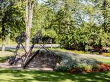 |
Parkā blakus pusloka tiltiņam ir novietotas trīs milzīgas dzelzs atslēgas, kuras balsta akmens mūris un metāla arkas. Tās simbolizē trīs vēsturiskos centrus un to vienotību – Siguldu, Turaidu, Krimuldu. Dobēs pie šī objekta sezonāli zied dažādi kultūraugi. |
|
 |
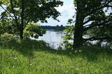
This is a short stretch of the Daugava River valley between Lielvārde and Dzelme, with islands and shallows in the river, as well as with reeds and wet meadows alongside it. During migration season, many goose-type and plover-type birds rest and feed here. The location is also an important nesting area for several other kinds of birds.
|
|
 |
Größe Steinkreisen. In der Mitte befindet sich eine oder mehrere „Steinkapseln” für einen Verstorbenen. Wurden im Eisen- und Bronzealter errichtet. |
|
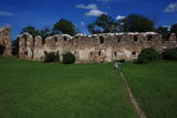 |
On the right bank of the Bērze River and in the western part of Dobele, the castle hill and its fortified forecastle were occupied between the 10th and 13th centuries, with an ancient town at its foot (currently the square between Tērvetes Street and the Liepāja highway). As was common, the Livonian Order used this ancient Semigallian castle hill to build a brick castle between 1335 and 1347. The castle was sacked during the 18th century, and its fairly impressive and beautiful ruins have been conserved. A viewing platform is part of the charm. |
|
 2 days
|
The Forest Trail follows small roads and trails through the woods. Along the route you will see the Ērģeļu Cliffs, where the observation terrace provides a great view of the impressive 700 m wide sandstone cliff and the beautiful natural landscape in the ancient River Gauja valley. One of the most beautiful places on the banks of the River Gauja is at “Caunītes” tourist lodging, where you will end the first day of the route. Further on the trail leads through pine forests and wetlands, across and around hills and slopes. One of the most beautiful views of the River Gauja opens from Sietiņiezis Rock, a 15 m high sandstone cliff where a circular 1.5 km trail has been constructed. Coming to Valmiera, you will reach the so-called “Dzelzītis” bridge (a narrow-gauge railway bridge) and continue walking along the River Gauja to Valmiera Centre. Sites of interest in Valmiera: St. Simon’s Church, ruins of the Livonian Castle and Valmiera Museum. There is also an adventure park “Sajūtu Parks” (“Park of Senses”), where you can walk on the barefoot trail, the tree-top trail and enjoy other activities. |
|


