
| No | Name | Description |
|---|---|---|
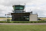 |
The current Ventspils airport began its life as a military object. Today regular passenger flights to and from Rīga have been suspended, and the airport is only used for small planes.
|
|
 |
A place where you can enjoy nature and food. The tavern Kogre got its name from Seven Fish Soup - crucian (koger), is the seventh fish. The owner is a fisherman, and together with his wife he prepares various dishes from his catch. |
|
 |
Atrodas uz Imulas upes un celtas 19. gs. sākumā. Uz dzirnavu vārtu staba redzama tēlnieces D. Ezergailes veidota pūce. Pūces dzirnavās savulaik uzņēma pazīstamo latviešu mākslas filmu Likteņdzirnas.
|
|
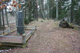 |
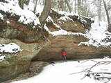
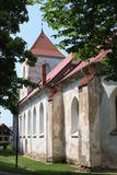
The Middle Ages and the beginning of the last century cemetery at the church of Mazirbe. It is surrounded by a moss-covered stone fence. There you can find a number of interesting sights-Werewolf's Tomb, Old Taizelis Tomb, Grand Pine, etc.. |
|
 |
The family company in the centre of Trikāta prepares a variety of chocolate delicacies - truffles, chocolates figures. During summer you can buy ice-cream made from the milk and cream of local producers. |
|
|
|
The Boulder of Subinaite can be found in Sakstagala rural municipality opposite Vaļenieku House that
is on the left side of the river Rēzekne. The base of the boulder is below the river level; it is 5,2 m long, 4,4
m wide, it rises about 1,6 m above the water level, about 2,5 m below the water level, capacity 26 m3.
Reddish surface is heavily eroded and full of moss. Protected since 1977.
|
|
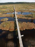 |
This reserve was set up to protect local swamps and surrounding wetlands. Please note that before you can visit the reserve, you must register with the local administration and visitor centre in the village of Tooma.
|
|
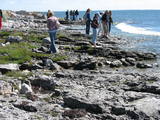 |
The national park was established to protect the 100 or so small islands that make up the archipelago of the local area. The largest island, the Vilsandi Island, is 6 km long and up to 2 km wide. You can rent a boat to get there, or, during appropriate conditions, you can walk across the sea and the small islands from the southern end of the Kuusnõmme peninsula.
|
|
 |
The Kaļķupe River valley was established as the Pilsupe River (formed by Kaļķupe River and Mazupe River) crossed the Blue hills of Šlītere to the South of Vīdale and Kaļķi. The distinct river valley has a branched network of gullies in which Devonian sandstone has been uncovered and can be seen in some locations. Puiškalns Hill (located at confluence of Kaļķupe River and Mazupe River), which was used as a castle hill and as a sacred location long in the past, is one of the most distinctive parts of the area. It is a popular tourist destination in the Talsi District. Hillside forests, various kinds of meadows and a wide range of plants are also of value in the local environment. |
|
 |
Located on the side of the Daugavpils-Krāslava (A6) road in Naujene, the museum features a replica of the room of a wealthy Latvian farmer with household objects from the 19th and 20th century. Younger visitors will be interested in Latvia's only diorama, "Underwater World," which will introduce them to the inhabitants of the Daugava River. An outdoor exhibition, "Daugava of the Heart," has information about the protected Curves of Daugava Nature Park and the protected Upper Daugava landscape region, as well as local cultural and historical values. The museum offers creative workshops and educational programmes. There is an apple orchard to the east of the museum. On the opposite side of the road, is the Juzefova (Juzepova) Park, which once was a baronial estate owned by Duke Bogdan Shahno. It no longer exists. The park has pathways, relaxation areas and information stands about the history of the park and the most interesting trees that are found therein. You will need at least one hour to walk through the park. |
|
 |
Pie Gārsenes pils atrodas bijušais muižas parks 4ha platībā un pie tā sākas arī Gārsenes dabas takas. Dabas takas vēsturiski tika veidotas vienlaicīgi ar pils kompleksa būvniecību un ieeja takās atrodama pie mākslīgi veidotā, ar bruģa pamatni izliktā barona peldēšanās dīķa. Takas sākumā saglabājusies ošu aleja, ko savulaik stādījis barona dārznieks, savukārt taku vidusposmā apmeklētājiem ir iespēja pasēdēt uz Barona krēsla - akmens ar cilvēku veidotu sēdvietu tajā. Kopumā Gārsenes mežā vijas dažāda garuma labiekārtotas pastaigu un izziņas takas - Kultūrvēsturiskā taka, Zaļā taka, Baronu pastaigu taka, Staburaga taka, ar ierīkotām atpūtas un ugunskuru vietām. Takās apskatāmi vairāk kā 40 unikāli dabas objekti, gan dižakmeņi, gan dižkoki, kā arī un pagasta ievērojamākie arhitektūras un kultūrvēstures pieminekļi. No 2016.gada maija Dabas takās ietilpst arī „Krēslas stundas taka”, kas īpaši patiks zinātkāriem mazajiem ceļotājiem. Taka stāsta par Rūķu dzīvi mežā un tās veidošanas pamatā ir stāsti no „Lielās Rūķu enciklopēdijas”. |
|
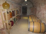 |
The shadowy cellar of the estate is a great place to hear about how homemade wine is made. You can taste rhubarb, black currant and strawberry wine along with local goodies such as cheese. Local farmers provide the ingredients for the wine. |
|
 |
The Healing Gardens is a part of the Upmaļi biological farm that occupies 125 ha of land. The 4th generation of Bergmanis family runs the farm. Māra and Dainis, the present farm owners, involve their family members to work for preservation of the old and rare fruit and berry cultivars that have been planted in the 30-ties of the previous century. The gardens also contain tree varieties that have medicinal powers and some rare varieties like elder, walnut tree, edible chestnut, mulberry tree and others. Together with the herb plantations, the Healing Gardens cover over 12 ha of land. The hosts have over 30 years experience in natural healing and Ayurvedic tradition. Based on this experience, they produce teas, balsams, creams, oils and other products under the brand name AnnaABergmans. |
|
 |
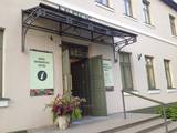
Viļāni Museum of Local History. Permanent exposition of the
town history from the ancient times to nowadays. Tours in Viļāni.
Working hours: Mon– Fri : 8.00 – 12.00,13.00 – 17.00, Sat., Sunday : closed |
|
 |
This is basically a grain farm, but in 2006 it also began to work as a dairy farm. In 2008, the farm began to produce cheese and cottage cheese. The farm has more than 200 dairy cows, using the milk to produce milk, yogurt, cheese and ice cream. |
|
 |
Šis ir viens no retajiem ceļiem, kurš saglabājies kā notikumu liecinieks. Ceļš ved no Krimuldas uz Siguldu. Jau vācbaltu apgaismotāja novadpētnieka – mākslinieka Johana Kristofa Broces 1794. gada zīmējumā "Siguldas un Krimuldas pilsdrupas" redzams lauku ceļš gar Krimuldas pili, pa kuru iet zemnieks un darba ratus velk zirgs. Lai braukšana pa Gaujas senlejas nogāzi ar zirga pajūgu būtu droša, ceļu izveidoja līkloča formā, tā uzbrauktuvi padarot daudz lēzenāku. Domājams, ka ceļš atjaunots 19 gs., kad Krievijas cars Aleksandrs otrais un viņa sieva ieradušies uz vizīti siguldā. Pāri ceļam bijuši vairāki mazi tiltiņi, ko iedzīvotāji dēvējuši par velna tiltiem. Tagad serpentīna ceļš kļuvis par romantisku pastaigu vietu. |
|
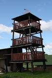 |
This is an interesting viewing tower which is part of one of the farm buildings. It offers a lovely view of the surrounding area.
|
|
 |
Atrodas Bauskas vēsturiskajā centrā, Plūdoņa ielā 13 a un ir šīs pilsētas daļas vecākā ēka. Dievnams celts 1591. - 1594. g. vēlās gotikas stilā, bet tornis piebūvēts 1614. g. Baznīcas iekšpusē atrodas nozīmīgi mākslas pieminekļi: altāris (1699. g., pārbūvēts 1861. g., mākslinieks J. Dērings), kancele (1762. g.) un ērģeļu prospekts (1766. g.) – abi Nikolaja fon Korfa dāvinājums, draudzes soli (17. gs. vidus – 18. gs. sāk.), senākais no koka veidotais Bauskas ģerboņa attēlojums (1640. g.), deviņas 16. – 17. gs. kapu plāksnes, epitāfijas u.c. Baznīca, kurā ir vērts ieiet! |
|
 |
A small settlement with a school, library and shop. North from the Vidale are visible remains of the windmill. Going towards the Gulf of Riga, the road crosses Shlitere Zilie mountain precipice with spectacular views during late autumn, early spring and winter, when there are no leaves on the trees and sandstone outcrops. To the left you can see Zilie mountain spring - a landscaped water taking place. Road that runs from the Vidale to Melnsils side, is called by the locals Knipeldambi. They say that it was built by the German army first During World War I, putting logs on the road and covering them with sand. |
|
 2 days
|
This route offers most unusual views. Seda is the only town in Latvia with Soviet-era planning from the middle of the last century, featuring a central square and streets stretching from it in a star pattern. The architectural style of apartment and public buildings is rather exotic. The Seda Swamp yielded peat moss during the first period of Latvia’s independence and is one of the largest industrial and environmental territories of its kind in Latvia and the Baltic States. Former peat fields have partly become flooded and are overgrown with reeds, thus creating an outstanding environment for nesting water birds and migrating birds which rest at the swamp. Peat is still being extracted, and perhaps you will be lucky enough to spot the “little peat moss train.” Route information from Latvijas Lauku forums |
|


