
| No | Name | Description |
|---|---|---|
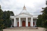 |
Atrodas Rīgas ielā 39. Dievnams celts 1848. – 1849. g. klasicisma stilā (arhitekts A. Štauberts), bet laikā no 1924. – 1934. g. pārbūvēts (A. Vizuļa projekts). Dievnama izskatu salīdzina ar Svētā Pētera katedrāles veidolu Vatikānā. Blakus baznīcai atrodas Rīgas ielas gājējiem domātā daļa. |
|
 |
The farm store Leppanide is only a 15-minute drive from Kärdla. The farm breeds goats and sheep, as well as grows various vegetables. |
|
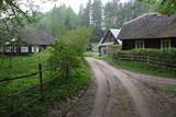 |
Liela meža masīva vidū gleznainās Būkas (Būka) upes krastos starp kokiem ieslēpies teiksmainais Vaišnoriškes ciems. Šis ir viens no skaistākajiem nacionālā parka etnogrāfiskajiem ciemiem. Vaišnoriške kā apdzīvota vieta sākusi veidoties 1756. g., kad šeit sena vēsturiska ceļa malā darbojies krogs. Pirmā viensēta ciematā ir zināma no 1830. g. Šodien redzamā apbūve ir tapusi g.k. 20. gs. sākumā. Ciems ir palicis cilvēku atmiņās ar liepu medu, jo meža velšu vākšana un biškopība bija viena no galvenajām šejieniešu nodarbēm. Tagad ciemā ir piecas sētas. No Vaišnoriškes var uzsākt laivu braucienu pa seklo un dzidro Būku. |
|
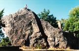 |
The Rock of Jana - Toma is claiming itself to be the highest (almost 8 m) rock in The Baltic. It is located in Kasispea village. |
|
 |
The Lazdiņi farm is one of the most modern farms in Latvia, located in the Krimūni Parish in the north-western part of the Zemgale lowlands. The farm focuses on grain farming (~1,100 ha), processing and storage. Owner Juris Lazdiņš is the chairman of the largest non-governmental organisations in the field of agriculture, and by contacting him in advance, agriculture experts and future experts can go there to exchange experiences. The farm is surrounded by the typical landscape of the Zemgale lowlands. |
|
 |
The spacious cafe in Gulbene with comfortable chairs and a tasty meal of the day menu. It is also possible to taste various types of pizza and dishes typical for the Gulbene district. Working hours: Monday-Thursday: 10:00 - 22:00, Friday-Saturday10:00 - 03:00, Sunday 11:00 - 22:00 |
|
 |
The cafeteria is on the main street in Līvāni, offering country cooking and Latvian dishes. Latvian cuisine: Potato pancakes, cold soup, pearl barley and barley porridge, pork ribs with sauerkraut, bread soup. Special foods: “Rocks of Dubna and Daugava” – potato dumplings stuffed with cottage cheese in a cream sauce. |
|
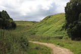 |
Found on the right bank of the Daugava, approximately half a kilometre upriver from the Skrīveri Agricultural Institute, the hill is in a place where the bank of the Daugava River Valley is split by the deep Ašķere stream valley. The castle hill was occupied beginning in the first millennium BC, with antiquities from the Lettigalian and Livonian tribes found there. During the 13th century, a brick castle was built on the hill, but it was sacked during the 17th century. Nothing remains of the castle. The castle hill is also known as Raven Hills, and it offers one of the most beautiful views of the central part of the Daugava. In the direction of Rīga, there is a field with a white cross that represents an ancient church. There is a hiking trail along the Ašķere stream. The area is well improved with four trails. The longest is the Daugava trail (10 km). |
|
 |
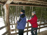
Elkas kalna saimniecība is located on the top of the scenic Elkas Hill, the place where the Gauja begins. Herbal teas, birch sap, jams and other healthy delicacies from local meadows and home-grown plants. There are also nature workshops, open-air picnic areas. |
|
 |
This is the ancient shore of the Baltic Ice Lake. We can only imagine the landscape 10,000 years ago, when the Kurzeme peninsula was covered with vegetation reminiscent of a tundra, and waves from the icy lake dashed against the ancient shoreline. We know that the lake was full of icebergs of various sizes. Today the cliff is more than 20 km long (some 9 km of it are in the Slītere National Park), and it is as much as 42 m high. It is the most impressive cliff of its type in all of Latvia. At the foot of the cliff are the Irve flatlands (the name comes from the Liv 'īrva' or 'īra', both of which refer to deer). The flatlands are the former bottom of the Baltic Ice Lake. The Blue Hills are crossed by many small streams and rivers (Pitragupe, Lorumupe, Kaļķupe, Mazupe, etc.). Their valleys are the basis for a branched and very complicated system of waterways which look particularly impressive when the trees are bare. In many places the cliffs and valleys display small areas of sandstone from the Narva suite. These are Latvia's oldest sediment cliffs that can be seen above ground. Although the Blue Hills are very impressive in scope, there are only a few places where there are important viewing areas (a viewing tower at the Dundaga-Mazirbe road, the view from the Šlītere lighthouse, the view from Mežlīdumi). The mightiness of the ancient shoreline can truly be enjoyed from the Cirste-Mazirbe road, the Cirste-Riepaldi road, Mežlīdumi and the Vīdala-Melnsils road). It is worth visiting the area in the springtime, when the slopes of the Blue Hills seem to be sinking under the fresh greenery. |
|
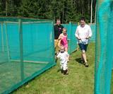 |
This labyrinth covers 3,300 m2. Visitors can make their way through the maze, trying to find the exit and handling clever tasks at some of the special twists and turns in the labyrinth. There is a playground for children, along with a workshop, a mud café and the “fir tree village.” |
|
 |
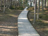
Lots of wild animals can be found in vast paddocks along the ancient Gauja river valley and its small tributaries – areas in which living conditions are as close to natural circumstances as possible. Here the visitor can find, if lucky, reindeer, deer, wild boars, bears, foxes, lynx, various kinds of birds, as well as aurochs. There is a dense network of pathways in the park, including lots of information. There is also a route for drivers and bicyclists. During the winter, it is used for distance skiing. There is also a visitors’ centre.
|
|
 |
The farm boasts one of the most attractive gardens in Viljandi County and is a feast for the eye for both seasoned gardeners and nature lovers. A footpath takes visitors from the garden to the edge of Paistu primeval valley. |
|
 |
The restaurant is at the bridge across the Salaca River, offering traditional Latvian dishes, as well as dishes from other European countries. Latvian cuisine: Sprats with egg, fish soup, farmer’s breakfast, cooked butter beans, chicken livers with mashed potatoes, Kurzeme stroganoff, potted farmer’s stew, crepes and potato pancakes with potatoes, stacked rye bread. Special foods: Homemade sheet pastry. |
|
 |
Meklējama pilsētas centrā - Tirgus laukumā 11. Dievnams uzcelts 1886. g. Ēkā atrodas vairāki nozīmīgi mākslas pieminekļi – gleznas, krucifikss (18. gs.) u.c. Baznīcas dārzā apskatāma skulptūra “Latgales māte” (tēlnieks B. Buls) un piemineklis politiski represēto piemiņai (tēlniece V. Dzintare). Baznīca ir apskatāma arī no iekšpuses. |
|
 |
The café is in the centre of Aglona on the edge of the Dagda road (P60). |
|
 |
The nature reserve “Plieņciema kāpa” is founded in 1987 and covers 60.6 hectares of land. Since 2005 it is a Natura2000 site. The nature reserve protects a 150-200m wide and 3.5km long part of a distinct, continuous dune rampart. The dunes shelter Plieņciems village protecting from sea winds. The key natural values here are rare and protected biotopes of national and European significance: “Wooded dunes of the coast 2180” in the area of 61.8 ha, “Fixed dunes with herbaceous vegetation, 2130 (grey dunes)” in the area of 8.27 ha, “Shifting dunes along the shoreline with Ammophila arenaria (white dunes) 2120 in the area of 3.20 ha”, “Black alder swamp forests 9080”, ) in the area of 2,68 ha, as well as rare and protected species of Latvian and European significance including eastern pasqueflower (pulsatilla patens), Rolling Hen-and-chicks(Jovibarba sobolifera), Nothorhina muricata, Wryneck (Jynx torquilla), Woodlark (Lullula arborea). In the nature reserve, there is a “Vabu square” – a deflation in the dune where for centuries local fishermen have been drying nets. In the 18th and 19th centuries ships were built here. Nine ships have been built here in 1882 - 1925. The four-masted gaff-rigged schooner with hoisting engine “Eurasia” was completed in 1925, the largest ship built by the Kurzeme fishermen. It was one of the works of Martin Morgenstern (1866-1945), a famous shipbuilding master. Thanks to dunes, Plieņciems village was a popular holiday resort and has been mentioned in written sources already in 1738. Clergymen and landlords with their families used to stay here. In 1808, a merchant from Riga bought the local pub and replaced it with a massive two-storey building with a large ball-room and dining hall. On July 15, 1810, a sea bathing facility was opened for health treatment. For arrival of the empress Elisabeth Alexeievna, the wife of emperor Alexander I of Russia, who was a grandson of Catherine the Great, the road from Tukums town was repaired, the two highest hills were levelled, a road passage was dug across the Plieņciems dune, and a lime-tree alley was planted to facilitate access to the beach and bathing spot. Later, in 1920ies, the resort circles consisted mainly of the Kurzeme region landlords. There was a dance-floor in the park of Plieņciems village, and a special orchestra played music for resort guests three times a day. |
|
 |
Vilsandi nacionālā parka „sirds” un divpadsmitā lielākā Igaunijas sala (garums - 6 km, platums – 2 km). Tā ir ļoti „jauna” sala, kas sākusi veidoties pirms ~ 2000 gadiem zemes garozas celšanās rezultātā, savienojoties divām salām, kas noticis pirms ~ 350 gadiem. Cilvēki salu sāka apdzīvot 18. gs. un to galvenā nodarbe bija zvejniecība, kuģu būve, nelielā apjomā – lauksaimniecība. Līdz 2. pasaules karam te bija ap 200 iedzīvotāju, kuri vēlāk salu bija spiesti pamest PRSR pierobežas režīma zonas dēļ. Nozīmīgu Vilsandi daļu aizņem mežs un kadiķu lauki. To visā garumā šķērso grantēts - zemes ceļš ar atzariem uz jūras krastu. Salu ar kājām var izstaigāt vairāku stundu laikā, iepazīstot vietējo apbūvi (daļa arī mūsdienās celtas ēkas) un Tolli sētu, kur pēc nostāstiem dzīvojis nīderlandiešu jūras braucējs Johans Dolls, kā arī vējdzirnavas. Noteikti ir jāaiziet līdz salas rietumu krastam, kur atrodas Vilsandi bāka un bākas uzrauga saimniecības ēkas. No šejienes ir labi redzamas Vaikas salas. Šodien uz salas pastāvīgi (visa gada garumā) dzīvo tikai trīs cilvēki. |
|
 |
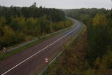
Ja no Pervalkas (Pervalka) pa Kuršu jomas krastu ar kājām (neliela taka) dosimies Klaipēdas (ziemeļu) virzienā, pēc 10 – 15 min gājiena nonāksim līdz Arkļu ragam (Arklių ragas, citās kartēs – Žirgų ragas), kam iepretim ~ 0,2 km attālumā no krasta uz mākslīgi veidotas akmeņainas salas slejas 14 m augstā bāka. Tā celta ~ 1900. g. vietā, kur savienojas trīs kuģu ceļi no Klaipēdas, Nidas un Ventes raga (Ventės ragas). No šejienes paveras fantastisks skats un Nagļu dabas rezervāta iespaidīgajām kāpām. |
|
 |
Located in the northern part of Valmiera, the Valmiermuiža Estate mansion (Neo-Baroque Style) was built between 1764 and 1771 by Prince August Friedrich of Schleswig, Holstein and Soderburg. Over the course of time it has been owned by other people. According to modern evidence, the mansion was a one-story building with a Baroque tower and a two-story addition in the early 20th century, which made it appropriate as a summer home and hunting lodge. The building burned down in 1918. Two years later, Valmiermuiža became a prison camp for captured soldiers. Later the addition to the mansion was restored and used as an elementary school. In 1936, the building became a prison, and it was once again a prison camp for captured soldiers during World War II. Later the building burned down again, and the ruins were removed. Still surviving is the Valmiermuiža tower, with ceiling paintings that are a cultural monument, as is the surrounding park. The Valmiermuiža brewery is alongside the historical monument, thus providing second wind for the whole region. |
|


