
| No | Name | Description |
|---|---|---|
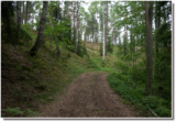 |
The Green Dune is beyond the Krāči hills (Krāckalni)
and is the second most distinct dune formation in the
national park. It runs for more than three kilometres,
separating the Raganu and Zaļais swamps. An old
earthen road is at the foot of the dune, and that’s the
basis for the route.
|
|
 |
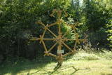
This is an institution that offers leisure activities for people of all ages. Creative workshops and various lectures are focused on families to facilitate creativity. There are kites that allow children to release their dreams into the sky. |
|
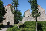 |
Exploring of Sigulda can be started with a visit to Sigulda castle ruins. The construction of the castle was begun by the Knights of the Sword Order in 1207, but in 1236 it was rebuilt for the needs of the Livonian Order. Sigulda castle suffered much from the wars in the second half of the 16th century and in the beginning of 17th century. During the Northern War, it is burned down and is no more restored. Today south-western building of the convent and the tower of the main gate, behind which is the inner forefront of the castle with open air stage, which offers impressive views over the Gauja valley. Currently the reconstruction of castle ruins is in progress. Construction of New castle (owner - Prince Kropotkin) in the South of the Sigulda took place from the 1878 until 1881. From 1923 - 1940 the building was the Palace of Writers, but during the Soviet years - Cardiology sanatorium. Since 2003 Sigulda district council is located there. The manor complex includes wooden house (middle of 19th century), which was Kropotkin's family home, barn (turn of the 18th - 19th century), gardener's house (19th century) and a stone fencing (19th century.) If we make our way from New Castle in a north-eastern direction, after almost 2 km we will reach Vejupite ravine. There you can see the shallow (3.6 m) but high (6.1 m) in Peter's Cave and deep Pucu ravine with Krauklupite. At the conjunction of ravines of both streams rises a Satezele hill fort (plateau 90 x 75 m), where in the beginning of 13th century was the oak castle of Liv land chief (eldest) - Dabrelis. Near can be found Krauklu gorge - ravine of Vejupite left bank, with 11 m high sandstone walls and 5.2 m deep Krauklu cave. At the conjunction of Vejupite ravine and Gauja valley columns Paradise (Gleznotaju) Hill - a very picturesque place, painted and photographed since old times! The Paradise Hill can be reached with a electric vehicle. In the west part of Sigulda is located Ferris wheel (works during the summer) and Air cableway (streetcar) - the only this type of vehicle in Baltics (built in the 1969). Its self-supporting cable extends in 1060 m length and without any support joins the Gauja River valley banks between Sigulda and Krimulda ~ 40 m above Gauja River. Here you can enjoy excellent views! In the south-western part of Sigulda one can walk to mighty Beites precipice, which is split by the deep ravine of stream. On the west side of the ravine lies Keizarskats, which is located ~ 67 m above the Gauja level and offers good views of Krimulda and Turaida castle. Sight place was arranged here already in the 1862 when Russian Tsar Alexander II visited Sigulda. In the eastern part of the ravine wooden Keizarkrēsls (Emperor Stool) is located. |
|
 |
The café is located 200 m south of the Stāmeriena Castle in Vecstāmeriena. It is in one of the historical buildings of the local baronial estate and has an antique interior. It is possible to try out dishes typical for Gulbene district. |
|
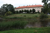 |
One of the largest castles in Kurzeme, this building has been preserved in fairly good shape. Work on its began in the mid-13th century, and it was commissioned by the heads of the Dome Cathedral in Rīga. In 1434, the estate was bought by the bishop of Kurzeme. The Maidel and Osten-Sacken dynasties owned it from the 16th to the 20th century. The Dundaga Castle burned down twice and has been rebuilt many times. The last reconstruction was in 1905, after the castle was burned down during the revolution. Of interest on both sides of the castle’s door are stone carvings of a knight and a bishop. In recent years, the hotel in the castle has been renovated, as has the second floor hallway and a terrace that is popular for weddings. There are many legends about the castle, including one about a wedding of elves and another about the Green Lady. Today the building houses the Dundaga School of Music and Art, a hotel, party rooms, the Dundaga Tourism Information Centre and various exhibitions. It is worth finding a guide to tour the castle. Groups of tourists can also order tastings of local foods. |
|
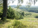 |
This territory was established so as to preserve the natural and cultural landscape of the most distinct part of the Alūksne highlands – a landscape which is made up of the highest hillocks in the area – Dēliņkalns Hill, Dieva Hill, Saules Hill, the Drusku castle hill, and the Kornetu-Peļļu sub-glacial river bed (one of the most significant terrain differences in Latvia). There are lakes, too – Lake Pilskalns, Lake Dzērve, Lake Ieva, Lake Raipals, etc. There are also significant biotopes – hillside and gully forests, various kinds of swamps and meadows, damp forests, etc., all with their own species of flora and fauna. There are nature trails and tracks for cross-country and downhill skiing in the area. There are three restricted natural areas in the territory – Korneti-Peļļi, the Avotu forest, and Dēliņkalns Hill. |
|
 |
Organising workshops for Udmurts and other Finno-Ugric national cuisines, learning the culture of other people through food. |
|
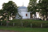 |
Varakļānu centrā, Rīgas ielas malā paceļas neliels paugurs, uz kura atrodas balta ēka ar 4 kolonnām un kupolveida jumtu, kas celta pēc Romas Panteona parauga. Kapela būvēta 1814. g. (arhitekts Vinčento Macoti), un tajā atrodas grāfu Borhu dzimtas apbedījumi. Kapelā bija novietoti arī Sv. Viktora pīšļi, kas pārvesti uz Varakļānu katoļu draudzes baznīcu. |
|
 |
A small part of the impressive fortifications of Liepāja, these encircle the city’s perimeter and its shoreline. They’re found at the Olimpija stadium. See also Objects No. 30077, 30078, 30079, 30080 and 30098.
|
|
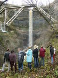 |
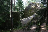
This is a cliff with various levels. Known as the North Estonian cliff, it stretches all along the shore of the Bay of Rīga in Estonia, including some of the local islands. The most expressive part in geological and landscape terms is the Saka-Ontika-Toila cliff, which is around 22 km long and offers an unusual natural environment. The cliff is as much as 53 m high, and it has a fairly virginal forest along its slopes. The layers of clay, sandstone, limestone, etc., come from the Cambrian and Ordovician periods. The Valaste juga (Valaste waterfall) is 24 metres high. After a longer period of freezing temperatures, the waterfall has a particularly impressive appearance. Seasonal waterfalls (8-10 m) can be found near the villages of Ontika and Toila.
|
|
 |
The park was established to protect the Venta River valley and the landscapes that are around its tributaries. On the west bank of the Venta, at Papilė, there is a cliff from the Jurassic period which is unique in the Baltic States, has been known since 1925, and has layers in which more than 300 forms of life have been identified over the course of time.
|
|
 |
Folkloras taka "Jāņkalni" iepazīstina ar mūsu senču rakstiem, zīmēm un dievībām, kas ir mūsu folkloras mantojums. Folkloras takas (garums: apm. 1,5 km vai 2 stundas) mērķis ir arī iepazīstināšana ar senlatviešu ieražām, folkloru, kā arī tautu dainu izprašana. Piedāvā iziet Latvijas karti - labirintu ar 19 etnogrāfiskajiem novadiem. Gids Jums sniegs izsmeļošu stāstījumu un atbildes uz interesējošiem jautājumiem.
|
|
 |
Die Größe dieses Feldsteins ist eindrucksvoll, obwohl er nach dem Volumen (262 m3) nur der 16. größte Feldstein Estlands ist. Die Länge beträgt 10,7 m, Breite – 6,5 m, Umfang – 27,8 m. |
|
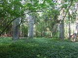 |
The Ukri forest on the border of the Dobele district is what is known as a vast forest. It has oak trees (including many huge ones), linden trees, oak trees (large stands of oak are uncommon in Latvia), and other deciduous trees. A small area of the forest can be toured in the company of a guide to look at the animals of the area and their importance in the flow of nature. The restricted area protects forest habitats, plants and animals, including many that are typical of the southern areas of Latvia. |
|
 |
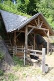
This venue produces homemade fruit, berry and dandelion wine from local products and with no preservatives, as well as interesting products such as spicy plum sauce and fruit and berry conserves. Groups of tourists can go on a tour and taste and purchase the products. |
|
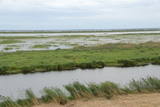 |
Dabas liegums atrodas dienvidaustrumos no Lubāna ezera un tas veidots purva un meža biotopu un tajos esošo sugu aizsardzībai. Gar teritorijas ziemeļu robežu iet Nagļu - Degumnieku ceļš (iekļaujas kopējā Lubāna dambju sistēmā), pa kuru apkārt Lubāna ezeram izveidots velomaršruts. Tas nozīmē, ka teritoriju var aplūkot arī "no malas", netraucējot tās dabiskās norises. Teritorija ietilpst arī Lubāna mitrāja kompleksā.
|
|
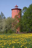 |
is the second oldest navigation structure in Latvia and the only one that is five kilometres from the shore, at the upper edge of the ancient Lake Baltic Ice. Since 2000 the lighthouse has not served its initial purpose, and now it is the home to the Nature Education Centre "Slītere" of the Slītere National Park. The centre offers exhibitions about lighthouses in Latvia and the history of the Baltic Sea. From the upper floor (102 m above sea level) one can see the coast of Saaremaa (approximately 33 km away). Alongside the lighthouse is the 1.2 km Šlītere nature trail. |
|
 |
The saloon is on the seashore with a lovely view of the beach at Saulkrasti. Here different water sports and entertainment activities are organised. Latvian cuisine: Cold soup, baked filet of cod, homemade steak haché, roast pork, pancakes with cottage cheese, caramelised oatmeal. |
|
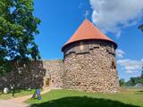 |
The Livonian Order built a fortified castle on the largest island in Lake Alūksne – Marijas Island (Pilssala Island) in 1342. It was linked to the land by a 120 m drawbridge. The castle had several forecastles, and it was regularly modernised and expanded until the end of the 17th century. It was one of the largest Livonian Order Castles, with similar ones found in Vastelina and Izborsk. Defensive barriers were put up around the castle, which survived until the Great Northern War. Its central part was blown up by the defeated Swedish military in 1702, after which Russians completely sacked it. All that is left are the castle ruins on the island, which is now linked to Alūksne and Temple Hill by two wooden bridges. An open-air stage alongside the castle ruins is used for various public events. |
|
 |
Until 13th century, Smiltene region was a part of Talava country, inhabited by Latgalians. After Crusaders invasion it was won by the Archbishop of Riga, and he built a stone castle on the steep river bank of Abuls in 1370. The following wars and epidemics did not spare the development of settlement, nor the people. Present shape of the town began to emerge in 19th century along with the vigorous activities of owner of Smiltene manor first Lieven. Until the World War I, wood working factory, hydroelectric power plant (established in 1901, first in the Baltics), and other companies were operating in Smiltene. In 1944 when the German forces retreated, much of the Smiltene historical buildings were destroyed in the fire. |
|


