
| No | Name | Description |
|---|---|---|
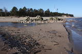 |
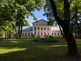
This is the most distinct cape in Latvia, with the waves of the Baltic Sea and the Bay of Rīga coming together. During storms, the waves can be as much as 7 metres high. The cape is an underwater shoal that stretches to the Kolka lighthouse, which is 5 km away. It is on an artificial island that was created between 1872 and 1875. When the island became stable, the 21 m lighthouse was installed in 1883. Manufactured in St Petersburg, the lighthouse became operational on July 1, 1884. Today the island contains the building for the supervisor of the lighthouse, several ancillary buildings and an impressive fog bell. A monument to men lost at sea that was sculpted by Ģirts Burvis is on Cape Kolka, as is a wrecked wooden ship, presumably from the 19th century. There is also a rock that is known as the “heart of Europe,” because the Latvian folklorist Krišjānis Valdemārs believed that the cape was the centre of Europe. There are stands with information about Valdemārs, and the Latvian Border Guard uses facilities that were once in the hands of the Soviet Coast Guard. Cape Kolka is an important place for migrating birds during the season, and it has a visitor centre and a summer café. There are unusual pines on the beach that were washed onto it during storms. Under the water around the cape is the largest ship graveyard in the Baltic Sea. It is a dangerous place for swimmers because of changes in the flow of water and shifting sands. At the end of the cape are the ruins of an old lighthouse that was built in the 18th century and lost during the latter half of the 19th century. |
|
 |
The so-called Comet Fort was built on the Left Bank of the Daugava at its mouth, not far from the present Daugavgrīva lighthouse. It was built around the same time as the other forts of Mangaļsala (around 1808, although some sources say 1788). There were four Kane-type 152-mm cannons. The defensive batteries at Komētforts and Mangaļsala repelled a British naval attack in the Daugava estuary in 1855. It has to be added that Komētforts is a cultural monument of local importance. If we go along the shore of the sea from the Daugavgrīva nature reserve toward the Daugavgrīva lighthouse and scale the frontal dunes (without going past the sign which says “Closed Territory. Border Zone.”), then we can see the positions of the cannons, as well as underground cellars where munitions were once stored. The territory starts approximately 500 metres before the Daugavgrīva lighthouse and stretches to the lighthouse itself. During Soviet times, the territory was closed to civilians, because many secret military objects were in this area and in Bolderāja.
|
|
 |
Eine der größten befestigten Siedlungen im Bezirk Harju, befindert sich auf einer Erhebung des natürlichen Kliffs Nordestlands. |
|
 |
A small and forested territory with sulphurous springs, among which the most popular one is the Ellīte sulphur spring. It has sulphurous water with a low level of minerals, and the water supposedly has medicinal properties. The area around the stream is well-appointed, and a pathway leads to it. The stream is considered to be the source of the Iecava River. The restricted area is there to protect biotopes and protected plants which are in the area.
|
|
 |
Located on an island in Lake Dviragio, the Salu Estate and its park, when viewed from above, are reminiscent of the boundaries of Lithuania. The park to the east of the estate is a mixed-type park and is one of the oldest ones in Lithuania. Back in the day, it was a forest park where trees were never cut down. The park featured maple, linden, elm, aspen and other local trees, and they are now around 200 years old. A winding path links the alley to a park trail by the lake. The various plants and fragments of alleys have survived to the present day. |
|
 |
Atrodas Amatas ielejas augstajā krastā, autoceļa (A 2) Rīga – Veclaicene malā. Plašs ēdienu klāsts, lielas porcijas, iecienīta tālbraucēju šoferu maltītes ieturēšanas vieta. |
|
 |
Saimniecībā tiek audzēti Helix Aspersa Maxima sugas gliemeži. Ekoloģiska produkcija. Tie tiek baroti tikai ar vietējiem dārzeņiem un gliemežiem domāto īpašo barību. |
|
 |
Beautiful views are accessible from the Sabile castle hill (steps, a location for relaxation), Upurkalns Hill (no improvements) and Briņķpedvāle, which part of the Pedvāle Open-Air Art Museum. There are also the Drubaži nature trails. The road between Kandava and Sabile which runs along the right bank of the Abava and the Aizdzire-Kalnmuiža road which runs on the left bank of the Abava also offer beautiful landscapes.
|
|
 2 days
|
This section of the seacoast of Vidzeme is of outstanding scenic beauty with a lot of rocky capes and boulders in the sea alternating with small, sandy coves where the small streams and rivulets, which dry out in summer, flow into. Occasionally, the beach is completely covered with the gray backs of stones. In Zvejniekciems you need to make a detour around the estuary of the Aģe River and the Skulte port. In some places, small patches of reeds appear, while near Tūja you will see the first sandstone outcrops. Some part of the route can be covered via the beach or via a trail meandering through the dune forest with old pines. At the end of the route, you can see the unique lamprey fishing method - Svētupes nēģu tacis. |
|
 |
Vom 18. Jh wurde die Stadt ein russischer Marinestützpunkt. Von 1962 bis 1994 war Paldiski ein Übungszentrum für atomare U-Boote der Sowjetischen Marine mit zwei auf dem Festland befindlichen Kernreaktoren (ung. 16.000 Beschäftigte) und eine "geschlossene Stadt". |
|
 |
The café is located right by the old brick bridge of Kuldīga and boasts a wonderful view over Ventas Rapid, the widest waterfall in Europe. Offers grilled dishes in summer, as well as burgers, steaks, shashlik and pastries. |
|
 |
The open-air museum was proposed in 1992 by the sculptor Ojārs Arvīds Feldbergs, and it is located on the banks of the Ancient Abava River valley and on land that was once part of the Firkspedvāle and Briņķpedvāle estates. The park features contemporary art, and the museum also organises symposiums, creative workshops and other events. |
|
 1 day
|
Tūrisma gide Ineta Jansone piedāvā ekskursijas grupām pa Raganu purvu. Izveidota taka uz sēra dīķiem (koka celiņi 800 m garumā). Ekskursijas laikā Jūs uzzināsiet par augstā tipa purvu un unikālu biotopu – sēra avotu izplūdes vietu Ķemeru Nacionālā parka teritorijā. Šeit sastopami savdabīgi purva ezeriņi, piesātināti ar sēra baktēriju radītām nogulsnēm. Ezeriņu krastos sastopami īpašu sugu augi. Sēra dīķu apkaimē var sajust gaisā sērūdeņraža smaržu. |
|
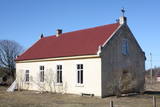 |
This is a simple one-story building with a cross on its roof. The Pitrags congregation was established in 1890, but the church was built in 1902. It was restored after a World War I fire in 1925 and 1926, and restored again during the period of Latvia's restored period of independence. |
|
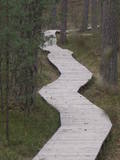 |
One of the most attractive and informative nature trails in the environs of Rīga. It leads the visitor around the 17-metre Ragakāpa dune, which is most interesting. People can learn about the habitats of the dune areas and the plants and animals of the area. Some of the pine trees are as much as 100 years old and more. The trail is 2km long in each direction and will take some two hours to traverse. This is part of the Ragakāpa nature park.
|
|
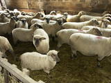 |
The farm breeds more than 150 sheep. There is a location to feed lambs, and the owners organise animal auctions and “Sheep Days” events. You can take a tour of the farm and purchase pedigreed sheep and sheep-related products. |
|
 |
Traķu pussalas pils austrumu mūrim pieguļ ar mežu apaudzis iespaidīgs pilskalns (uzved koka kāpnes) – t.s. Upurkalns, kurā pirms mūra pils celtniecības stāvējusi koka pils. 1779. g. dominikāņu mūki sagrautās Pussalas pils vietā uzsāka baznīcas celtniecību. Jau vēlāk – 1822. – 1823. g. vienā tās daļā uzcēla dominikāņu klosteri, bet otrā – kapelu. 1990. g. šeit izvietoja Traķu vēstures muzeja administrāciju, bet 2005. g. kapelā izveidoja Sakrālās mākslas izstādi. 2011. g. ēku kompleksā notika vērienīgi rekonstrukcijas darbi. |
|
|
|
The old peat quarries is the next place
beyond Ķemeri where vast amounts of
peat were extracted, primarily during the
first period of Latvia’s independence.
|
|
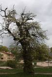 |
This is the thickest wild pear tree in Latvia. The tree is particularly beautiful when it is blossoming.
|
|
|
|
Mājas saimniecība „Pie Tēvoča Garika" piedāvā iepazīties ar nelielu dzīvnieku kolekciju. Dažus dzīvniekus var pabarot un paglaudīt. Te iespējams apskatīt gan mājas dzīvniekus, gan savvaļas dzīvniekus. Par katru dzīvnieku sniedzam informāciju. |
|


