
| Nr | Name | Beschreibung |
|---|---|---|
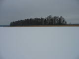 |
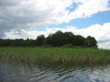
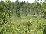
Es gibt sechs Inseln im Großen Baltezers – See – die Inseln Auzu, Priežu, Mazā, Liepu, Ropažu und Meldru. Sie zeichnen sich durch eine große Pflanzenvielfalt aus, einschließlich Laubbäumen, Schwarzerlen und Kiefern. Das Territorium kann ganz gut von der Seite der lutherischen Kirche Ādaži aus betrachtet werden. Der Große Baltezers – See ist ein beliebter Ort zum Angeln, einschließlich Eisangeln während des Winters.
|
|
 |
Viens no dažiem Latvijas dzidrūdens ezeriem. Apskatāms no Lubānas - Ļaudonas ceļa malas pie Visagala. Lai saudzētu šo ezeru, tajā esošos aizsargājamos biotopus un sugas, ūdenstilpē nevajadzētu peldēties lielām cilvēku masām un pieļaut cilvēka darbības produktu nonākšanu ezerā.
|
|
 |
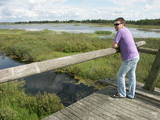
Das ist ein großes Territorium mit Küstenwiesen, alten Flüssen und Schilf. Es befindet sich in einem Gebiet, wo die Daugava floss – zwischen Vecmīlgrāvis und Vecāķi. Hier gibt es Binnendünenwiesen, mit dem sehr seltenen Silbergras bedeckt. Vecdaugava ist ein wichtiges Nistgebiet, hier werden verschiedene seltene Pflanzenarten gefunden. Am südlichen Ende der Vecdaugava – Insel, bei Skanstnieki, kann man noch Überreste von schwedischen Befestigungsanlagen aus dem Mittelalter finden. Das Regionale Forschungs- und Fischereimuseum von Vecdaugava befindet sich auch hier.
|
|
 |
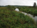
Palieņu un mitrās pļavas abos Dubnas upes krastos, kuras nelielā posmā var vērot no Rožupes - Vārkavas ceļa. Piemērotā laikā šeit dzirdēsiet griezes balsi, kas ir Eiropā izzūdoša putnu suga.
|
|
 |
Von den vielen Inseln im See Rušons sind zehn geschütze Naturgebiete. Außerdem sollen die Laubwäler auf den Inseln und die sich hier befindlichen gefährdeten Pflanzen geschützt werden. Eine alte Kultstätte – der Heilige Felsen von Rušons - befindet sich auf der Insel Upursala.
|
|
 |
Ilziņš jeb Vestienas dzirnavezers pazīstams ar nostāstiem par tajā "periodiski uzpeldošām kūdras salām". Saskaņā ar vietējo iedzīvotāju sniegtajām ziņām, minētā parādība gan sen jau vairs nav novērota. Tajā pat laikā ezers un tā apkārtne ir nozīmīga daudzu aizsargājamu biotopu un sugu dzīves vieta. Ezers ietilpst Vestienas aizsargājamo ainavu apvidū. Ezeru var redzēt, braucot pa Ērgļu - Gaiziņkalna ceļu. Var pakāpties arī blakus esošajā paugurā (ziemeļos no minētā ceļa un ezera), no kura paveras plašāka skatu perspektīva.
|
|
 |
Dieses Territorium wurde eingerichtet, um den Nesaule – Berg zu schützen, der ein bewaldeter Hügel ist und Nadel- und Feuchtwaldgebiete enthält.
|
|
 |
Nature restricted area surrounds Tasu Lake and swampy shores of it in a narrow band. The territory was established to protect rare nesting and migratory birds. The territory is easily overseen from the narrow gravel roads all around the area not entering the actual protected area. Tasu Manor house is located to the South of nature restricted area.
|
|
 |
Dieses Territorium schützt die Biotope der Küstendünen und der Dünen von Plieņciems, die sich über die ganze Strecke bis nach Ķesterciems erstrecken. Das ist ein vielbesuchtes Gebiet, aber das Objekt Plieņciems wurde nicht ausgebaut. Es gibt jedoch einen hölzernen Fußweg durch die Düne zwischen Plieņciems und Ķesterciems. Hier wurde auch ein Erholungsgebiet errichtet.
|
|
 |
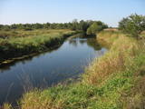
Nature restricted area is located to the South from former railroad Ventspils-Liepaja and includes approximately 6 km of Uzava River (and the old drainage system). The territory was used for agriculture during Soviet time, now it starts overgrow by scrubs. The protected nature values – rare bird species, including corncrakes, variety of grassland habitats and plant species. Territory is not useable for tourism activities. There is a possibility to get good insight into the North part of restricted area from the road Alsunga – Berzkalns where information stand is located.
|
|
 |
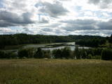
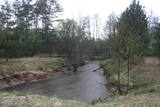
Palieņu pļavas starp Rūjienu un Rūjas ieteku Burtnieku ezerā, kurām raksturīga liela augu un putnu sugu daudzveidība. Tās robežojas ar bijušiem Rūjas zivju dīķiem, kas šobrīd aizaug ar mežu. Rūjas palienes var vērot gan braucot ar laivu pa Rūju, gan arī no ceļa, kas ved uz minētajiem dīķiem. Tur izvietots informācijas stends.
|
|
 |
Das Territorium wurde eingerichtet, um den Sumpf, einen sumpfigen Wald und eine Reihe seltener Vögel zu schützen. Der Sumpf Niedrāji-Pilka kann mit trockenen Füßen durchquert werden, während man die fast unberührte Natur genießt. Das ist vom Damm der Schmalspurbahn, die für drei oder vier Kilometer vom Nordosten zum Südwesten des Sumpfes führt, möglich oder zu Fuß auf dem gut markierten Rundweg auf dem östlichen Teil des Damms.
|
|
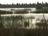 |
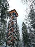
Seit der Mitte des vorigen Jahrhunderts wurde in der Seda – Heide Torf abgebaut, trotzdem bleibt es eins der wichtigsten NATURA 2000 Territorien in Lettland mit einer grossen Vielfalt an Landschaften, Biotopen und Biologie – insbesondere Vögel. Dies ist ein guter Ort zur Vogelbeobachtung während der Vogelzugsaison, ein Beobachtungsturm wurde zu diesem Zweck am Sumpf errichtet.
|
|
 |
Dieses morastige Gebiet war Teil der Litorina - Meereslagune und ist ein Gebiet, wo es viele seltene und geschützte Vögel gibt, z.B. leben und nisten hier Spechte. Ein Teil des Territoriums kann von der Straße Tukums-Kolka aus überblickt werden.
|
|
 |
The tower is at the western end of the Seda swamp, accessed from the side of Jērcēni. Transport is limited here. The tower is in the area of the swamp where peat moss is extracted. It offers a broad view of the ponds of Seda and a boat rental facility that is nearby. It is an appropriate location for bird-watching during the season of migration. There is another bird-watching platform near the town of Seda. This is part of the ZBR. |
|
|
|
Das Gebiet wurde eingerichtet, um diesen Teil des Ogre – Flusstales zu schützen, das ein Flussbett aus der Eiszeit hat und Wiesen mit entsprechenden Biotopen und Populationen. Unter anderem die Bergulme und die Flatter - Ulme, die nicht oft in Lettland zu finden ist.
|
|
 |
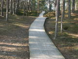
Dabas liegumā "Lielie Kangari" atrodas 33 metrus augsts skatu tornis, kura virsotnē atrodas platforma, no kuras paveras skats uz Kangaru ezeru un Lielkangaru purvu. Dabas liegumā izbūvēta arī nepilnu divu kilometru gara pastaigu taka ar tiltiņiem un skatu platformu pie ezera. Takas sākumā izvietotais veselības maršruts ikvienu apmeklētāju aicina kārtīgi izvingroties un izkustēties. Apmeklētāju informēšanai un izglītošanai visas takas garumā izvietoti arī informatīvie stendi ar fotogrāfijām, kas apvieno varenu stāstu un teiku kopumu par notikumiem, vietām, tēliem un parādībām dažādās apkārtnes vietās. |
|
|
|
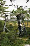
Atrodas Zebrus ezera austrumu krastā pie Latvijas Valsts mežu laivu bāzes. No torņa labi pārskatāms Zebrus ezers, ziemeļu virzienā – Ezerlūķu pilskalns. Laivu bāzē – atpūtas vietas. |
|
 |
Bejas meža dabas liegums veidots no reljefa viedokļa - interesantā, pauguru un starppauguru ieplaku saposmotā teritorijā, kuru klāj vecs un varens egļu mežs. Bejas mežā atrodas viena no Alūksnes rajonā vairākām "Velna pēdēm" - dziļa, krāterveida ieplaka, ko veidojis kūstošais ledājs.
|
|
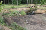 |
Nature restricted area has been established in old and overgrowing gravel pit and where rare species in Latvia - Natterjack toad (Bufo calamita) can be found. Natterjack toad needs open sand – gravel area therefore the population of it is decreasing once gravel pit is overgrowing by bushes. The population of this amphibian is depending on the activity of people in the area. There is very little chance to find Natterjack toad just by entering the restricted area, therefore please respect this area as especially sensitive.
|
|


