
| Nr | Name | Beschreibung |
|---|---|---|
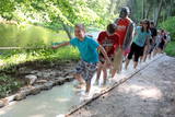 |
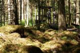
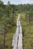
The first barefoot trail created in the Baltic States in the recreation complex "Valguma pasaule", which is located on the forested shores of Lake Valguma. When walking on the path, the feet "massage" sand, wood chips, clay, peat, gravel, cones and various other materials. |
|
 |
An den Ufern von Urstromtal der Gauja und deren kleinen Zuflüsse leben in weiten Gehegen lettisches Freiwild: Edelhirsche, Rehe, Wildschweine, Bären, Füchse, Luchse, verschiedene Vogelarten und Wisente. Im Park wurde ein dichtes Netz an Pfaden angelegt und auch eine Auto- und Fahrradroute, die im Winter als Langlauftrasse genutzt wird. Besucherzentrum.
|
|
 |
Die wichtigste Erscheinung des Waldes von Sasaļi ist der eutrophische See Sasalis, sowie der ungewöhnliche See Melnezers. Von bedeutung sind auch die verschiedenen Waldtypen des Gebietes. Der See Sasalis ist ein beliebter Platz für die Erholung und zum Schwimmen.
|
|
|
|
2015. gadā uzceltais skatu tornis atrodas dabas parkā „Daugavas loki”, Daugavas ielejas kreisajā krastā – Daugavpils novada Vescalienas pagastā. No torņa aplūkojama izcilā Daugavas loku ainava. |
|
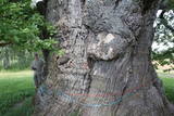 |
Most of the great tree’s mighty branches are gone, and among those that are still there, the thickest ones are held up by supports, and the tree’s hollow centre is protected against snow and rain with a little roof. This is the thickest Common Oak (Quercus robur) in Latvia and the Baltic States. Indeed, it is one of the thickest oak trees in all of Northern Europe. The tree is a gorgeous part of the surrounding landscape. There is a car park and an information stand nearby.
|
|
 |
Im Wald von Kaltene ist ein sagenumwobenes Naturwunder – Kalvas von Kaltene bzw. von Valna zu besichtigen. Das Entstehen dieser Anhäufung im Wald, 2 – 3 km von der Küste entfernt ist mit den Küstenbildungen des Baltischen Eissees verbunden. Die größte Anhäufung ist Velna kalva (Teufels-Kalva). Seinerzeit war Velna kalva eine schöne Anhäufung, so große, dass “sich bis Gipfeln der Bäume streckte”. Auf den früheren Karten wurde die absolute Höhe dieser Anhäufung angegeben – 20 m. Diese Anhäufung bestand aus Steinen verschiedener Formen. Die Steine waren sowohl voll kugelförmig als auch in einer Tellerform. Diese Anhäufung wurde fast vollständig in den 1960er – 1970er Jahren vernichtet, da daraus die Schotter für Straßenbau gewonnen wurde. Heutzutage ist nur ein ziemlich kleines Fragment des Unterteils von Kalva erhalten geblieben. Die Länge dieses Fragments beträgt ca. 300 m, aber die Höhe – 2 m. Die Wissenschaftler äußern eine Meinung, dass diese Anhäufungen im Altertum Sakralorte sein könnten, da viele Sagen und Legenden sind darüber geblieben. Um die Anhäufung zu besichtigen, wurde einen Naturpfad mit den Informationsständen und einem nicht großen Parkplatz errichtet. (Die Quelle: Roja TIZ) |
|
 |
Ap 200m garš un līdz 15m augsts ainavisks atsegums upes labā krasta asā līkumā. Tam iepretim otrā krastā (500m) Līgatnes dabas takas.
|
|
 |
Der Pfad liegt an der Küste der Rigaer Bucht, man kann kleinere Buchten und Landspitzen betrachten, die Küste ist steinig oder zugewachsen. Am Ende des Pfades befindet sich ein Ausichtsturm zur Vogelbeobachtung, denn im Frühling und in der Zeit des Vogelzugs sammeln sich in der Umgebung von Kaltene vielfältige Gänsevögel, Regenpfeiferartige und andere Vogelarten.
|
|
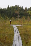 |
The small Andrupene swamp is found to the North of the Andrupene Farm Museum in a deep area between hillocks. It is a high-type swamp with an open central part, and it is 130 m long and 120 m wide. There are stands of white alder alongside the swamp. In 2009, the administrators of the Rāzna National Park restored a wooden educational pathway that had been established originally by the Andrupene Elementary School. Today there are stairs, a viewing platform, wooden pathways, and information stands. |
|
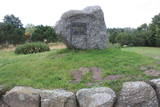 |
Pāvilostā ir trīs parki. Pāvilostas centrā (pie kultūras nama) atrodas Piecdesmitgades parks, kuru 1929. g. iekopa skolotājs un novadpētnieks Ernests Šneiders. Vienu ozolu tajā esot iestādījis Latvijas Valsts prezidents Gustavs Zemgals. Simtgades parks ar piemiņas akmeņiem tapa Sakas labajā krastā jau kā turpinājums iesāktajam. Vecākais no Pāvilostas parkiem - Upesmuižas parks (19. gs.) atrodas tuvu Liepājas – Ventspils šosejai. Upesmuižas pils nav saglabājusies (nodedzināta 1905. g.). Parkā apskatāms sens akmens sols (perimetrs 5,55 m) un Upesmuižas parka Lielais akmens. Domājams, tas ir kultakmens. |
|
 |
Der flache und fast zugewachsene See Engure (65% seiner Oberfläche) ist einer jener lettischen Seen, die vor allem von Vögeln bevorzugt werden. Es ist eines der Terrains, die von der Ramsar-Konvention über Feuchtgebiete verwaltet werden. 186 Arten von Nistvögeln wurden hier ermittelt. Das Gebiet zeichnet sich auch durch eine große botanische Vielfalt aus (mehr als 800 Pflanzenarten). An der Küstenlinie wechseln Sandstrände mit Küstenwiesen ab. Es gibt Wälder, Fischerdörfer, Feuchtgebiete, die die große Vielfalt der Landschaften und Arten sichern. Die Auen des Sees und des Meeres sind Weideland für Wildtiere - Pferde, blaue Kühe usw. MehrereVogelbeobachtungstürme stehen Besuchern zur Verfügung, ebenso der Orchideenpfad.
Die Ornithologische Forschungsstelle liegt am Ostufer des Engure-Sees. Eine einzigartige schwimmende Station - von Ornithologen gebaut - befindet sich auf dem See. Die Landschaft ist nicht nur für Urlauber, sondern auch für Wanderer, Radfahrer und Vogelbeobachter geeignet. Ein Erholungsplatz und eine kleine Ausstellung befinden sich neben der Ornithologischen Forschungsstelle. |
|
 |
Das ist eins der größten Moorgebiete in Lettland und liegt zwischen den Orten Babīte und Olaine. Der größte Teil des Gebietes besteht aus Torf. Relativ unberührt ist der nördliche Teil des Sumpfes, wo es einige sehenswerte Sumpfseen gibt, die die Landschaft des Moores bilden. Das Moor ist eines der wenigen in Lettland, wo der westliche und der östliche Moortyp nebeneinander existieren. Das ist ein wichtiger Ort für geschützte Vögel. Ein Naturpfad und ein Aussichtsturm werden hier in nächster Zukunft eingerichtet.
|
|
 |
Nacionālā parka galvenā ainavas dominante. Ezers ir ~ 8,4 km garš un līdz 3,3 km plats. Tā austrumu krasti pārsvarā ir ar mežiem apauguši, ziemeļrietumu krasts – purvains, bet rietumu krastā parādās apdzīvotas sētas un simpātiskā Plateļu (Plateliai) pilsētiņa, kur meklējamas skaistākās skatu vietas. Ezera krastos ir labi attīstīta infrastruktūra - tūristu mītnes, ēdināšanas uzņēmumi (Plateļos), ūdenssporta un atpūtas inventāra noma. Ūdens dzidruma dēļ, Plateļu ezeru ir iecienījuši zemūdens niršanas entuziasti. Ezerā ir vairākas salas, no kurām interesanta ir Pils salas (Pilies sala), uz kuras no 15. – 16. gs. atradās muiža. Pastāv uzskats, ka senie Plateļu apkārtnes iedzīvotāji sākotnēji ir dzīvojuši uz salas, kuru ar krastu savienojis uz pāļiem celts tilts. Jāpiemin, ka 15 gs. pirmoreiz pieminētā Plateļu pilsētiņa atradusies uz Šventorkalņa (Šventorkalnis) kalna. Apkārt Plateļu ezeram ir izveidots ~ 24 km garš velomaršruts. Tā ir ļoti laba iespēja iepazīt parku videi un ceļotāja veselībai draudzīgā veidā. |
|
 |
Nature restricted area is established to protect various wetland habitats – Big Kirba Bog and protected plant species within it. Only the West part of the Bog is a protected nature area. The rest of the bog is used mainly for intensive extraction of peat and large cranberry cultivation. Nature restricted area of the bog has no tourism infrastructure therefore is not useable for tourist visits.
|
|
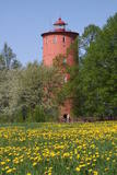 |
Der zweitälteste Navigationsbau in Lettland, und der einzige, der sich 5 km vom Meeresufer entfernt an der obersten Seite des Baltischen Eissees befindet. Seit 2000 wird die Funktion des Leuchtturms hier nicht mehr erfüllt, stattdessen ist hier nun das Naturbildungszentrum „Slītere“ des Nationalparks Slītere untergebracht. Hier kann man Ausstellungen über lettische Leuchttürme und die Geschichte der Ostsee sehen. Aus dem obersten Geschoss (102 m über dem Meeresspiegel) kann man die Küste der Insel Saaremaa (ca. 33 km entfernt) sehen. Neben dem Leuchtturm verläuft der 1,2 km lange Slītere Naturpfad. |
|
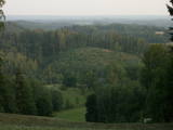 |
From the highest point in the Alūksne highlands, you will see an unusually beautiful view of the surrounding forested hillocks and the small areas of meadows and farmland. Sadly, there are no improvements to the location, which can be difficult to access. It is on private property.
|
|
|
|
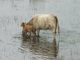
Metāla tornis Kazari upes kreisajā krastā, ~ 5 km attālumā no Matsalu līča. No torņa redzamās Kazari deltas palieņu pļavas atrodas tikai 0,3 – 1 m augstumā virs jūras līmeņa, tādēļ pavasara palos un stipru vētru (īpaši rietumvēju) laikā ūdens appludina milzīgu teritoriju. Uzskata, ka platības ziņā šīs ir vienas no lielākajām Eiropas palieņu pļavām, kas ir nozīmīga dažādu tārtiņveidīgo putnu sugu ligzdošanas, dzērvju un zosveidīgo putnu atpūtas un barošanās vieta. Ir pagājis laiks, kad zemnieki Matsalu pļavās ganīja govis un pļāva sienu, tādēļ šobrīd pļavu apsaimniekošanu veic nacionālā parka administrācija. |
|
 |
Wanderzentrum von Lahemaa beschäftigt sich mit Popularisierung von Naturschutz und Natururlaub – wir pflantzen Bäume, bauen und stellen Nistkatsen auf. Unseren Gästen bieten wir Kanuwanderungen, Moorwanderungen und Abenteuer auf Geländebogen- und Geländearmbrustpfad im Nationalpark Lahemaa an. Für gemütliches Relaxen gibt es einen Kaminraum und Sauna mit Badefass. |
|
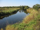 |
Palieņu un mitrās pļavas abos Dubnas upes krastos, kuras nelielā posmā var vērot no Rožupes - Vārkavas ceļa. Piemērotā laikā šeit dzirdēsiet griezes balsi, kas ir Eiropā izzūdoša putnu suga.
|
|
 |
Ein 3,5 km langer Pfad quert den Viru Moos in Richtung Süd–Nord. Von einem Holzaussichtsturm eröffnet sich einen Blick auf eine typische Hochmoorlandschaft mit einigen Seen, Aushöhlungen und morastigen Stellen. |
|


