
| Nr | Name | Beschreibung |
|---|---|---|
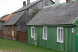 |
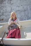
Die Stadt Pāvilosta ist eine ziemlich neue Stadt, die sich an der Küste der Ostsee bei der Mündung des Flusses Saka herausgebildet hat. Im Mittelalter befand sich der Hafen für Seeschiffe 6 km von der Küste entfernt – an dem Zusammenfluss der Flüsse Tebra und Durbe. Eine bedeutende Zeit war im Leben des Hafens die Regierungszeit des Herzogs Jacob, als hier Seeschiffe angelegt haben. In Folge des Polnisch-Schwedischen Krieges musste der Hafen von Saka geschlossen werden. Der heutige Hafen an der Mündung von Saka hat sich in der Mitte des 19. Jhs. an dem Fischerdorf Āķagals herausgebildet. Im Jahr 1878 wurden die Mündung des Flusses vertieft und die Molen gebaut. Hier wurden zweimastige Segelschiffe gebaut. Die Weltkriege haben die Schiffsflotte zerstört, aber die Fischereitraditionen wurden immer fortgesetzt. Im Jahr 1991 hat die Ortschaft den Status der Stadt erlangt. Heute ist Pāvilosta als ein beliebter Ort der Segler und Windsurfer, sowie der Sommerferiengäste bekannt. Auf die Segler wartet hier der Jachthafen. |
|
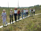 |
This is a highland swamp with several little lakes. At the SE of the area is a wooden trail.
|
|
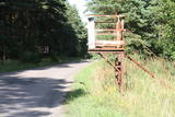 |
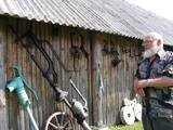
Die ehemalige Anwendung der Abteilung der Grenzwache in Ozoliņi – da war ein Zentrum für Meldegänger und Lehre. Heutzutage befindet sich im Objekt der Stab und Kasernen des Bataillons der Landwehr von Ventspils. Das Territorium ist für Zivilpersonen geschlossen. Am Weg sind die Metallkonstruktionen erhalten geblieben – der ehemalige Prüfungsstelle der Passierscheine und Dokumente.
|
|
 2 Tagen
|
Это один из 6 маршрутов путешествий в серии «Насладитесь деревней!», который приглашает посетить «Дары села» – хозяйства и предприятия всевозможных видов и отраслей, которые открыты для посетителей и предлагают экскурсии, попробовать, осмотреть и приобрести свои изделия. Там можно увидеть домашних животных, современные сельские хозяйства, мастерские ремесленников, приобрести сельскохозяйственные продукты – хлеб, мед, домашнее вино и пиво, сыр, ягоды, фрукты, рыбу, мясо, овощи, чаи и другие, выращенные в деревне дары. По дороге можно отобедать в сельских корчмах. Примерное время прохождения маршрута: три - четыре дней, в зависимости от количества выбранных достопримечательностей и времени, отведенного для их осмотра. |
|
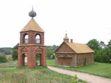 |
One of the most unusual houses of worship in the national park, this one has a red brick tower, and together with local residential buildings it makes up an interesting cultural landscape. The prayer house is not open to the public. |
|
 |
Die Geschichte des Gutshofes reicht bis 1422 zurück. Später gab es hier Kriegsgefangenenlager, Pferdeverleih, Traktorenstation und Geschäft. Heute ist hier die Keramikwerkstatt, deren Produktion auch vor Ort verkauft wird. Es besteht die Möglichkeit auch selbst Gegenstände zu formen und zu dekorieren. In der Holzwerkstatt kann man die Holzbearbeitung beobachten. |
|
 |
In Elly wird hausgemachte Eiscreme zubereitet, auch werden Unterkunft und ein köstliches hausgemachtes Frühstück angeboten.
|
|
 |
Štikāni Old-Believers Prayer House. The construction works of the church were held in 40s of the 20
th century on the site of the previous church built by brothers Rogozini. You should see Gospel (the protected
art object).
|
|
 11 Tagen
|
Auf dieser Tour werden die Reisenden das schönste historische Erbe und Kulturerbe besichtigen, das sich nach vielen Jahrhunderten erhalten hat: mittelalterliche Burgen, verschiedene Landgüter und prachtvolle Schlösser. Ein Teil der Tour führt durch den Nationalpark Gauja mit vielen großartigen Aussichten auf Wiesen und alte Wälder, wo auf Höfen das gewohnte Landleben gelebt wird. Eine malerische Straße verbindet die drei Burgen – Sigulda, Turaida und Krimulda, die sich alle an den hohen Ufern des Flusses Gauja befinden. Die Straße führt an einer der ältesten Kirchen von Lettland vorbei und Richtung von zwei attraktiven Landgütern Birini und Igate, die im 19. Jh. gebaut worden sind. Den nächsten Tag erholen Sie sich in dem luxuriösen Hotel des Landgutes Dikli. Weiter führt die Tour durch die charmante mittelalterliche Stadt Cesis mit ihren mächtigen Burgruinen und dem neuen Schloss nebenan. |
|
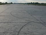 |
Der Flugplatz von Rumbula wurde als ein Militärflugplatz nach dem Zweiten Weltkrieg aufgebaut. Der Flugplatz wurde am Ufer von Fluss Daugava aufgebaut an dem Ort, wo sich viele Einzelhöfe befindeten. Nach dem der Flugplatz von Spilve seine Tätigkeit eingestellt hatte, wurden nach Rumbula die Flugapparaten der Zivilluftfahrt und nach Flughafen von Riga – die Technik der Kriegsluftfahrt versetzt. Heutzutage wird der Name „Rumbula” meistens mit dem Autohandelsplatz assoziiert. Ein Teil des Autoplatzes befindet sich im Territorium des ehemaligen Flugplatzes. „Ein Erbe” in gewisser Art ist die Verschmutzung von den Tanken des Brennstoffes des ehemaligen Flugplatzes, wo das Petroleum aufbewahrt wurde. Im Territorium des Flugplatzes werden die Flüge mit Paraplanen durchgeführt.
|
|
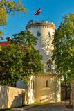 |
Cēsis is in the centre of the Gauja National Park, but it is not part of the park as such. There are many interesting places in Cēsis to visit and examine. The oldest part of the town is of key interest. The origins of Cēsis can be found at Riekstu hill, which is 18 metres high. Between the 11th and 13th century, there was a wooden castle here built by the Vendians. The hill is in the central part of the castle park, and it offers a good view of the park, pond and the ruins of the Cēsis castle, which can be accessed via a long cascade of stairs. The Cēsis castle (see below) was built in the early 13th century as a residence for masters of the Livonian Order, and it was one of the strongest fortresses in the Baltic territories. Alongside it is the New Cēsis castle, which was built in 1777 where the gate fortifications once stood. The Cēsis Museum of History and Art is in the building, alongside which is a visitors centre and the Cēsis Tourism Information Centre. From the tower of the castle, there is a fine view of the castle ruins, St John's Lutheran church and the northern part of the town. Opposite the New Cēsis castle are stables and a wheelhouse (both from the first half of the 19th century). The Cēsis Exhibition Hall is there today. You can look at the exteriors of the granary, the hut for coachmen, and the old brewery. On the other side of the street is the romantic Maija park, which was installed in the 1830s. The park is popular among parents with children, because there is a playground there. From this area, you can walk down some of the old streets of the town – Lielās Katrīnas, Mazās Katrīnas, Mazā Kalēju, Kalēju and Lielā Līvu streets, plus Līvu Square. The wooden buildings along the streets date back to the late 18th and early 19th century. Torņa Street, which weaves its way along the defensive walls of the Medieval castle, offers a look outside the church of a sculpture by Matiass Jansons, "As the Centuries Pass". Legend says that if you rub the lantern carred by the Old Man of Time, you can see the future. One of the most impressive buildings in Cēsis is St John's Lutheran Church, which was built in the late 13th century for the Livonian Order. It is a basilica built in the Roman style and with Gothic elements. The tower, which is 65 m high, was built in 1853. The building was reconstructed several times during the 20th century. Inside the building are grave epitaphs for masters of the Livonian Order and for bishops. The pulpit was installed in 1748, the oak altar followed in 1858, and the altar painting "The Crucified One" dates back to 1862. The stained glass windows around the altar are of great artistic value. The organ was built in 1907 by the E.F. Walker Company, and the instrument is one of the best concert organs in Latvia. A sun clock featuring the year 1744 is at the south-western corner of the church. It is worth climbing the church's tower. At the foot of the building is Rose Square, which began as a market square in the mid-19th century, remained in place until 1927, and was restored in 2008. This is the central square in the town today. During the Medieval Era, there were stockades here, along with the city's well. Rīgas Street has been the main street of the old town from the very beginning, and it is here that you will find the most architecturally outstanding buildings in town from the 18th and 19th centuries. They include the former Cēsis City Hall, the Fābers building, and the Princess building. At one end of the street is Līvu Square, where, during the 13th century, there was a church, a cemetery and a gate in the town walls. Today the square features a lighted fountain which is on the site of a 13th century well known as Lejas Šķimbēgs. At the other end of the street is a reconstruction of the foundations and surface elements of the Rauna gate that was a part of the town walls in the 14th and 15th centuries. The site offers a good idea about Medieval fortifications and the size and mightiness of gates therein. |
|
 |
At a lovely place in the Gauja National Park in the Vaidava Parish, guests can examine ancient tools, mechanisms and household objects. Guides will talk about how these various items were used. There is a guesthouse for overnight accommodations, and there is room for tents and picnics.
|
|
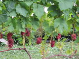 |
Einer der größten Weingärten in Lettland mit über 50 Rebsorten. Bei den angebotenen Führungen erzählt der Winzer über den Anbau von Wein und konsultiert bei Fragen zum Thema. Weiterhin gibt es Verkostungen und man kann Rebstöcke kaufen. |
|
 |
Akmensrags (das Steinkap) – ist ein wichtiger Ort für Vögel während der Migration, Überwinterung und auch im Sommer während dem Federtausch. Von den geschützten Vogelarten begegnet man hier am meisten der Zwergmöwe, dem Sterntaucher und dem Prachttaucher. Das Territorium befindet sich gegenüber der Region Pāvilosta und die Fläche beträgt 25 878 ha.
|
|
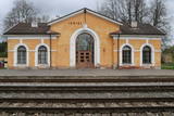 |
Ramocku stacija atklāta 1889. gadā reizē ar dzelzceļa Pleskava-Rīga atklāšanu. 1916.gadā pēc jauna dzelzceļa izbūves līdz Gulbenei, šīs stacijas nozīme ievērojami pieauga. 1918.gadā tā kļuva par divu dažādu sliežu platumu dzelzceļa iecirkņu saskares staciju. Intensīva vilcienu kustība caur šo staciju tika izvērsta Brīvības cīņu laikā. Sadursmes pie Ieriķu stacijas notika jau 1918.gada decembrī. 1919.gadā jūnijā te sākās Cēsu kaujas. Starp Cēsīm un Ieriķiem vācieši uzbruka igauņu bruņuvilcienam. Par dažādiem nopelniem Brīvības cīņu laikā Ieriķu apkaimē, vairāki karavīri saņēma apbalvojumus, arī Lācplēša kara ordeņus.1919. gadā stacija nodēvēta par Ieriķiem. Otrā pasaules kara laikā te atradās lokomotīvju depo.1953.gadā depo vietā izveidoja stratēģiskās rezerves tvaika lokomotīvju bāzi. Pēdējā tvaika lokomotīve L-3599 Ieriķu bāzi pameta 2002.gadā un tagad ir redzama kinopilsētā Cinevilla.Ieriķu stacija vairākkārt pārbūvēta.Otrā pasaules kara laikā nodedzināta pavisam. 1956.gadā uzbūvē pašreizējo ēku. |
|
 |
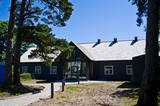
Das Café befindet sich im Zentrum von Balvi, am Rande der Brivibas Straße (Richtung Vilaka). Hier werden hausgemachte Speisen angeboten, darum ist es ein beliebter Ort für Mittagessen. |
|
 |
Livonian Community House at Kolka was opened in 2019. It is a place where you can get to know the Livonian culture of Northern Kurzeme, learn about traditional activities, listen to the sound of the language, and get an idea of the cultural and historical heritage of the coast. In House you can organize and attend cultural events, seminars, trainings, exhibitions, and also receive tourism information. |
|
 |
This is a small area with lots of different terrains – high hillocks, distinct river valleys, thermal streams, continental dunes, etc.
|
|
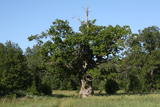 |
The tree is in the middle of an untended field. Despite many dead branches and the messy surroundings, the tree is beautiful and well visible from the road. It is the third thickest tree in the Baltic States.
|
|
 |
Находится за Гробиньским водохранилищем на берегу реки Аланде (ул. Пиладжу, д. 3). Туристический клуб «Ога» с 1 мая 2013 года планирует здесь организацию разных связанных с жизнью викингов мероприятий, во время которых можно будет войти в образ викинга, отправиться в поход на корабле викингов (в соответствующей одежде) по реке Аланде, а также познакомиться с окрестностями, которые связаны с тематикой викингов. Рядом с поселением установлена деревянная фигура викинга с рогами (от коров, пасущихся на Витиньских лугах на берегу Лиепайского озера). |
|


