
| Нo | Название | Описание |
|---|---|---|
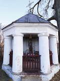 |
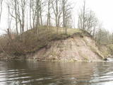
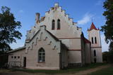
Распятие Курпинику известно как место, где были сняты кадры
фильма Я. Стрейча „Дитя человеческое”. Распятие в свое время находилось
во дворе дома Доната Клидзейса, деда писателя Яниса Клидзейса,
живущего в Америке. С тех пор святое место несколько раз меняло
внешний вид, но сохранило прежнюю фигуру Христа.
|
|
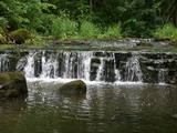 |
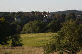
The ancient Abava River Valley between Kandava and the place where the river flows into the Venta River is the most expressive river valley segment in Kurzeme in terms of landscape and terrain. The valley is 30 to 40 metres deep and as much as 300 metres wide. The territory is distinguished by great diversity of a biological nature (more than 800 kinds of plants), featuring many different biotopes and natural monuments such as streams, waterfalls, cliffs, huge rocks, and many cultural and historical monumentssmall towns such as Kandava and Sabile. In both cases, the town centres are national monuments of urban construction. Popular tourist destinations include Vīnakalns hill in Sabile, where wine-making grapes are grown, as well as the open-air art museum at Pedvāle. To protect cultural treasures, a cultural and historical territory, “Abava River Valley” has been established. Wild livestock live at Drubazas and Tēvkalni to “maintain” the landscape. There are nature trails for tourists, and the Abava is the most popular river for water tourists in Kurzeme. Information is available at the tourist information centres in Kandava and Sabile. such as castle hills, churches, ancient burial grounds, and
|
|
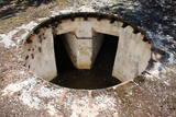 |
В небольшом населенном пункте, где сегодня расположена только одна гостиница, – в Олмани находились две важные береговые батареи. Их объединяло название Краснофлотская. До 1955 года в той, которая базировалась на юге от Олмани, размещались четыре 152-мм артсистемы типа «Канэ», которые изготавливались во время Первой мировой войны и широко применялись СССР для защиты территорий побережья Балтийского моря в Эстонии и Латвии. Сегодня в этих местах сохранились небольшие концентрические земляные валы. После 1955 года к северу от Олмани базируется новая батарея - четыре 152-мм артсистемы типа МУ-2. Они способны вести стрельбу на расстоянии 25 км. Во время строительства это была самая современная из всех береговых батарей того времени; обустройство батареи началось в 1952 году. Батарея находилась в боевой готовности и действовала до 1975 года, затем была законсервирована и держалась в резерве. Незнающему трудно будет найти месторасположение этой батареи, но находка стоит того. Сохранились бетонные платформы для установки и подземные бункеры. Действительно, одна из впечатляющих батарей побережья Балтийского моря!
|
|
 |
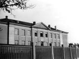
In 1888, the building, provided for a doctor’s needs, was donated by Baron Alexander Alexei von Pistohlkors to the parish of Pēterupe Lutheran Church. Along with the building, Baron Pistohlkors also donated 6 hectares of land and 10 000 roubles for the doctor’s use. Arvēds von Engelhards became the first medical doctor in Pēterupe. In 1890, the first pharmacy was opened in one room of the clinic, serving people from a wide area; it remained in the building until 1895. This outpatient clinic was the very first stone building in Saulkrasti, the first health authority in a wide area, as well as the first pharmacy. Through its entire lifetime, the house was maintained from voluntary donations – at first by Alexander Alexei von Pistohlkors, then by churchgoers of Pēterupe Parish – therefore by the money of the villagers. |
|
 |
The roots of Saulkrasti Secondary School reach back to Pabaži, to 1912, when a young teacher – Olga Veicmane (after marriage: Cīrule) arrived from Riga to teach the sea captain Reisons’ daughter. Soon many other tutor-seekers joined her and in autumn of 1912 a school was established in Pabaži. The school had a good reputation, and pupils came from the entire surrounding area. In January of 1913, the school was moved to more spacious premises at 20 Rīgas Street. |
|
 |
Одна из наиболее высоких дюн нашего побережья. В советское время в дюне велись копательные работы, так как песок использовался для производства силикатного кирпича. В 80-е годы ХХ века копательные работы были прекращены. Самая высокая часть дюны (хороший вид) сохранилась и поросла сосновым лесом. Создана природная тропа горы Пусену. Находятся в Бернатском природном парке. |
|
 |
Möglicherweise die am höchsten gelegene Imkerei im Baltikum, ca. 300 m über Meeresspiegel. Die Bio-Bienenprodukte werden auf dem Berg Gaiziņkalns und in der Umgebung geerntet. Es werden eine Führung durch den Bauernhof, Imkerei-Workshops und eine Verkostung der Bienenprodukte angeboten. |
|
 |
Befindet sich auf einem schönen Platz – auf der Südseite der Pils-Insel nahe der Füßgängerbrücke über den Fluss Driksa. |
|
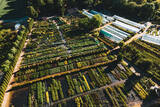 |
Eine der reichhaltigsten Baumschulen in Lettland, die zudem auch noch reich mit natürlicher Schönheit gesegnet ist. Hier werden über 1000 verschiedene Arten, Sorten und Formen angeboten. Führungen durch Laub- und Nadelbäume, Ziersträucher, Hecken, Kletterpflanzen, besonders gepfropfte Bäume und Sträucher, die man allesamt auch kaufen kann. Ein sehenswertes Dendrarium (Schaugarten), Beratungen. |
|
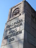 |
Eine mit Kiefern bewachsene Düne, auf der sich ein Denkmal für die Krieger des 6. Rigaer Regiments – Beschützer der Stadt im Jahr 1919 befindet. Hier führten die Krieger des Regiments einen schweren Kampf gegen die zahlenmäßig überlegenen Truppen der Bermondts Armee und setzten die Befreiung von Rīga und Pārdaugava (Stadtteil am linken Ufer der Daugava) fort. Ein zentrales Element des vom Bildhauer Kārļis Zāle errichteten Denkmals (gewendet zur Slokas Straße) ist eine 12 Meter hohe Wand mit der Abbildung des Löwenkopfes unter dem geöffneten Gatter des Rigaer Tors. Seitlich der Wand befinden sich Flachreliefs, die alte lettischen Krieger und lettische Krieger in Uniform von 1919 darstellen. Auf dem Dünengipfel befindet sich einen Platz mit Altar, eine Opferschale und eine Erinnerungstafel mit Namen der gefallenen Krieger. Das Denkmal wurde 1937 vom Präsident der Republik Lettland Kārlis Ulmanis eröffnet. |
|
 |
Where the little Rumbiņa river flows into the Daugava (on the left bank of the little river opposite the Lielvārde park), there is the Dievkalns castle hill that has been reduced by the waters of the Daugava. It is also known as the Cepure hill. According to antiquities that have been found here, representatives of Baltic tribes lived here from the first millennium BC to the 6th or 7th century AD. The level of the Ķegums hydroelectric power plant can be reached by a staircase from which the best view of this object can be found.
|
|
 |
The hill is the highest point on the shores of the little Slocene River valley, and it is located in Tukums, at the side of Jelgavas Street. It opens up a broad view of the Slocene River valley and the town of Tukums with its historical centre on the opposite side of the valley. The view is particularly interesting in the evening, when the town is lit up. There is a monument to the liberators of Tukums.
|
|
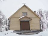 |
St. Virgin Mary Roman Catholic Church of Dukstigals. The
wooden church was burned down in the World War II and restored in 1947. The church has the icon of Our
Lady in the central altar and the statue of Our Lady.
|
|
 |
Known as Alšvanga in the past, this place was mentioned for the first time in 1231 in an agreement that was signed between the deputy legate of the pope in Rome and the Courlandian tribes of the region. The Livonian Order ruled the territory until 1561, and from 1573 until 1738 the order’s castle belonged to the von Schwerin dynasty from Pomerania. It during the rule of this aristocratic family that a stone church was built in honour of Archangel Michael, and local residents began to convert to Catholicism. Alsunga became the Catholic centre for all of Kurzeme, and local residents became known as the Suiti (from the Schwerin suite). For nearly 400 years, Alsunga has been the historical centre of the Suiti territory. This is Latvia’s most conservative region and is widely known with unusual songs, colourful folk costumes and various folk traditions and beliefs. The Suiti have their own dialect, foods and many other things that have been long since abandoned or forgotten elsewhere in Latvia. The religious has commingled with the folk here in one unique whole. The Alsunga District covers 191 km2 and has some 1,500 residents. |
|
 |
Atrodas ļoti skaistā vietā – Krimuldas muižas kompleksa teritorijā, vienā no muižas vēsturiskajām ēkām. Mājīgs interjers, mākslinieka J. Annmaņa apgleznotas sienas. Piedāvā turpat muižā darinātos mājas vīnus un „Muižas stipro”. Garšīgas tējas, uzkodas un siltie ēdieni. |
|
 |
The Lutheran Church of St John in Aizpute is on Beidas Hill, which is near the steep river valley of the Tebra River and the Dzirnavdīķis pond which the river has created. The church is on an ancient Courlandian castle hill. The current Gothic appearance of the church dates back to 1860, when it was rebuilt. The tower dates back to 1730. This is one of the oldest churches in Kurzeme, and it features an interesting interior with many artistic monuments. |
|
|
|
Zirgi un citi lauku iemītnieki. Dažāda veida izklaides ar zirgiem gan saimniecībā, gan ārpus tās, un saimniecībā mitošo iemītnieku apskate. |
|
|
|
Eine der drei Anhöhen im Südestland mit malerischen Hügeln und schönen Aussichtsplätzen. Im „Zentrum” der Anhöne legt sich der mit Buchten reiche Pühajärv See (Heiliger See). |
|
 |
Die Gastgeberin des Strandhauses Tahku organisiert Workshops zum Marinieren und Einlegen von Gurken. Dabei herrscht eine fröhliche Atmosphäre. Das Gurkenfest Tahkuranna findet jedes Jahr am 20. August statt. Man kann dort auch Gurkenkonserve, lokale Lebensmittelprodukte und Handwerkserzeugnisse kaufen sowie Handwerkserzeugnisse selbst herstellen. |
|
 |
Piedāvā ļoti gardus Lietuviešu tradicionālos ēdienus. Var pieņemt līdz 140 personām. Ir āra terase un dzīvā mūzika. Pieņem bankas kartes, pieejama autostāvvieta. |
|


