
| Nr | Name | Beschreibung |
|---|---|---|
 |
The farm grows apples, pears and medicinal plants such as peppermint, marigold, etc. The owners also collect wild medicinal plants. An interesting tour is available, and you can purchase products at the farm or at the Latvian Eco Product Store at Barona Street 45-47 in Rīga. |
|
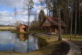 |
Badehaus am Flussufer von Jugla für Familien. Für Feiern nicht geeignet. Die maximale Bettenanzahl beträgt 6. Vielzahl von Aktivitäten für Eltern (Russische Sauna, Angeln im Fischteich) und Kinder (Spiele, Trampolin, Novus, Fahrräder, Fütterung der Kaninchen) im Angebot. Alle Annehmlichkeiten vorhanden. Möglichkeit Frühstück und Abendessen zu bestellen. Das Haus befindet sich 25 km von Riga und ist mit öffentlichen Verkehrsmitteln erreichbar. |
|
 |
Auces novads miniatūrā izveidots ar Auces novada nozīmīgākajiem un atpazīstamākajiem objektiem miniatūrā, kuri apdzīvoti ar mājdzīvniekiem. Iespēja Auces novada iedzīvotājiem un viesiem izveidot saikni ar dabu un vienlaicīgi iepazīt Auces novadu. Mazajiem apmeklētājiem izglītojoša saikne ar dzīvniekiem, iespēja tos pabarot ar saimnieku sarūpētajām veltēm. Veicināta Auces novada atpazīstamība caur miniatūriem objektiem. Tiek piedāvāta ekskursija, kuras laikā iespējams apskatīt 4 saimniecības: Zemnieku saimniecību ‘’Skabargas”, Lauku sētu ‘’Krastiņos’’, saimniecību ‘’Andulaiši’ un Lauku sētu ‘’Baltiņi’’. Ekskursija notiek gida pavadībā. Tiek gaidīti viesi, grupās no 10 cilvēkiem, ar iepriekšēju pieteikšanos. |
|
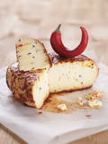 |
Nur 30 Autominuten Fahrt von Riga, im Zentrum der Stadt Ogre, befindet sich die Käserei "SierStelle". Am gleichen Ort, im Erholungskomplex „Policijas akadēmija” kann man die Gerichte aus der Käse der Käserei "SierStelle" genießen sowie Käse in der kulinarischen Abteilung kaufen. Die Auswahl der Käserei „SierStelle” besteht aus 31 Käsespezialitäten verschiedenes Geschmacks – sowie Salzkäse als auch Süßkäse. Ein besonderes Käse-Rezept ist am gleichen Ort in Ogre, im populären Kurort entstanden. |
|
 |
Z/S “Paldaži” ir 19. gadsimta Vidzemes lauku sēta un bioloģiskā saimniecība Limbažu novadā, kas apzināti kopj un saglabā Latvijas vēsturisko un kultūras mantojumu, tai skaitā lībisko. Saimniecību vada Andrejs Kovaļovs, kurš attīsta aitkopību, biškopību, kokamatniecību un pieredzes tūrismu, radot iespēju viesiem iepazīt gan tradicionālo lauku dzīvi, gan mūsdienīgu bioloģisko saimniekošanu. Apmeklētājiem tiek piedāvāta īsa ekskursija, kuras laikā iespējams iepazīt Paldažu apkārtnes vēsturi, saimniecības stāstu, Paldažu dižosi un bišu dzīvi. Savukārt izvērstā ekskursijā iekļauts arī dravas apmeklējums, neliela vaska sveču liešanas darbnīca un atpūta ar karstiem vai aukstiem dzērieniem. No maija līdz oktobrim saimniecībā noteiktos datumos tiek piedāvātas vakariņas un pusdienas ar jēra gaļas ēdieniem. Maltītes iespējams baudīt tikai pēc iepriekšēja pieraksta. “Paldaži” piedāvā autentisku lauku pieredzi, kas apvieno dabas tuvumu, senās sētas vidi un mierīgu gaisotni. Šī ir vieta, kur iespējams sajust Vidzemes lauku raksturu, iepazīt bioloģiskās saimniekošanas principus un uzzināt vairāk par Paldažu vēsturisko mantojumu. |
|
 |
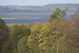
Das Territorium schützt die Küstenwiesen der Lielupe – Flussmündung, die einen sehr seltenen Habitat in Lettland darstellen. Das Schutzgebiet ist am linken Ufer des Flusses, wo eines der größten Gebiete mit wildem Engelwurz zu finden ist. Das ist ein wichtiges Nistgebiet für Vögel. Das Territorium wurde nicht für den Tourismus aufbereitet. Man kann es von der Baltā kāpas (Weiße Düne) aus sehen, die sich am gegenüberliegenden Ufer der Lielupe befindet. Von dort aus kann der Besucher die reizvolle Landschaft sehen, die von der Flussmündung und den sie umgebenden Wiesen gebildet wird.
|
|
 |
Saimniecība “Lejaskroķi” atrodas Abavas senlejā. Tajā nodarbojas ar truškopību. Saimnieku aprūpē ir ap 500 trušu, kā arī kazas un mājputni. Viesojoties saimniecībā, viesi varēs samīļot un pabarot trusīšus, kā arī apskatīt kazlēnus, kam ļoti patīk cilvēku uzmanība. Dzīvnieciņus iespējams apskatīt, iepazīt un samīļot, kā arī pabarot. |
|
 |
Das Ferienhaus Sala und die Sauna am See Vertukšne bieten Beschäftigungen und Dienstleistungen an, die eine gesunde Lebensweise unterstützen. Kuren zur Körperreinigung und Gewichtsverlust, Farbtherapie oder die heilende Lichttherapie Bioptron pro 1. |
|
 |
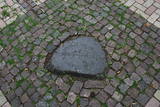
Befindet sich im südöstlichen Teil von Piedruja am Daugava -Ufer. Zum Stein führt den Piedruja-Pfad und einen örtlichen Landweg. Der Autor des Gedenksteins ist der Bildhauer Vilnis Titāns. Auf dem Stein ist das Wort Daugava in sieben Sprachen angebracht: auf Lettisch, Livisch, Estnisch, Polnisch, Russisch, Deutsch und Finnisch. Vom Stein ist sehr gut die weißrussische Stadt Druja am gegenüberliegenden Daugava-Ufer und eine große Insel zu sehen, die den Fluss in zwei Teile teilt. Vor der Reise nach Piedruja muss man die Aufenthaltserlaubnis fürs Grenzgebiet erhalten. |
|
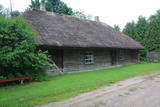 |
Wurde 1977 in einem alten Landhaus eröffnet, das mit einem Reeddach gedeckt ist. Die Ausstellung erzählt von bedeutenden Menschen, der Geschichte und Traditionen dieser Gegend. |
|
 |
Der Park befindet sichim Nordwestenvon Jēkabpils, am linken Ufer des Flusses Daugava, gegenüber der Insel Ādamsona (Krustpils) saliņa. Im 19. Jh. wurde dieser Park als ein Erholungs- und Veranstaltungsort für die Einwohner der Stadt eingerichtet. Man kann sicher behaupten, dass dieser Ort in der ganzen Welt bedeutend ist, weil sich hier ein Gedenkstein befindet, der der Tätigkeit des Akademikers – des Professoren der Universität Tartu, des Astronomen und Geodäten – Friedrich Georg Wilhelm von Struve (1793 – 1864) gewidmet ist. Dieser Stein ist an dem Ort enthüllt worden, wo Herr von Struve die Messung des Gouvernements Livland beendet hat. Der Längenkreis von Strūve (die Längenkreispunkte befinden sich auch in vielen anderen europäischen Ländern) ist in die Liste des UNESCO-Welterbes aufgenommen worden. |
|
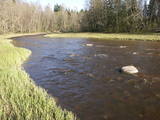 |
Der Naturpark im Tal des Ogre-Flusses befindet sich im mittleren Abschnitt des Flusses. Er wurde eingerichtet, um das unregulierte Flusstal und das ihn umgebende Territorium sowie die biologische Vielfalt mit dem Lebensraum zu schützen. Zum Beispiel das Gebiet, in dem seltene park-typische Wiesen vorhanden sind. Der Ogre-Fluss ist einer von Lettlands beliebtesten Flüssen für Wassertourismus im Frühling, besondern flussabwärts des Ortes Ērgļi, wo die technisch kompliziert zu befahrenden Braži – Stromschnellen sind.
|
|
 |
Iespēja ielūkoties audējas, rokdarbnieces, ekoloģisko rotaļlietu radītājas, tekstilmākslinieces projekta “100 deči Latvijai” autores Anneles Slišānes senajās Latgales lauku mājās.
|
|
 |
On the farmstead it is possible to look at sea-buckthorn plants, in August and September it is possible to take part in harvesting sea buck-thorns. The visitors will be told about sea- buckthorn, its growing and harvesting, its medical qualities and products. It is possible to see the production of sea-buckthorn products and try out the products themselves |
|
 |
Das Speisehaus Lümanda in alter Kirchschule bietet Ihnen leckeres Bauernmenü an. Beim Kochen wird nur biologisch reine Rohstoffe aus umliegenden Feldern benutzt. Fisch stammt von örtlichen Fischern. Nebenan gibt es ein Handarbeitsgeschäft. |
|
 2 Tagen
|
Маршрут, для прохождения которого не требуется специальная подготовка, если его проходить летом. Абава – это река с самой впечатляющей древней долиной в Курземе. Она есть и остается «классикой» Курземе. На Абаве несколько выраженных стремнин, обычно в местах, где в ее русле и по берегам появляются небольшие обнажения доломитовых пород. На участке между Веги и Рендой падение реки уменьшается и она становится более спокойной. Информация о маршруте от Latvijas Lauku forums |
|
 |
Nature restricted area includes eastern side of the lake with Lanupe River and North-east and South-east coastal areas. Restricted area has been established for protection of birds and floodplain meadows of the lake. To see the nature restricted area visitors do not have to enter it. There are great view points with wind generators of Grobina on the background from the road Vecpils – Rava – Aistere. Coastal areas which are not included in the restricted area are perfectly suitable for bird watching. There is located the smallest city by its population in Latvia to the South from the lake.
|
|
 16 Tagen
|
Diese Langstrecken-Tour überschneidet sich mit dem baltischen Küstenwanderweg von der litauischen Küste, die auf der Insel Rusnė beginnt und weiter zur Kurischen Nehrung, entlang der Ostseeküste bis zum Kap Kolka und schließlich bis nach Rīga führt. Auf dieser Route wandern Sie einige Abschnitte dem baltischen Küstenwanderweg entlang und erleben die Vielfalt der Küstenlandschaften: steinige Strände, Steilhänge, bewachsene Strände, Vogelwanderungsorte, breite Sandstrände. Sie werden mehrere Kilometer lang an einsamen Stränden spazieren, an denen niemand in Sicht ist, nur um sich plötzlich in lebhaften Ferienorten wiederfinden zu können. Es wird sowohl Abschnitte zum Wandern als auch Bustransfers geben. Zunächst besuchen Sie die eigenartige Insel von Rusnė mit ihren Vogelwanderungsgebieten, Aussichtstürmen und dem Delta des Flusses Nemunas – dem tiefsten Punkt Litauens. Als nächstes bringt Sie eine Fähre zur ebenso beeindruckenden Kurischen Nehrung – einer langen Nehrung von Sanddünen, die sich vor der Küste Litauens in die Ostsee erstreckt. Hier spazieren Sie über zwei Abschnitte des Küstenwanderweges, genießen die herrlichen Dünen und besuchen das litauische Meeresmuseum und das Delfinarium. Dann geht es weiter nördlich entlang der Küste durch den Regionalpark der Küste (litauisch: Pajūrio regioninis parkas) bis Sie die litauische Strandhauptstadt Palanga erreichen und wo Sie das Bernsteinmuseum besuchen. Als Sie die LT/LV Grenze zu Fuß überqueren, werden Sie den Naturpark Pape, sowie den Leuchtturm, die Wildpferde, das authentische Fischerdorf und das örtliche Museum besuchen. Als Sie weiter auf die einsamen Strände wandern, gelangen Sie auf die höchste Düne Lettlands – die Pūsēnu-Düne – und danach wandern Sie weiter bis zu der Siedlung Bernāti. Weiter kommen Sie in die windige Küstenstadt Liepāja an, die auch als lettische Hauptstadt der Rockmusik bekannt ist. Der Militärhafen von Karosta ist ein weiterer markanter Stadtteil von Liepāja – das Gebiet des ehemaligen Kriegshafens erzählt die Geschichte ihres militärischen Erbes. Danach wandern Sie weiter auf einsame Strände von Ziemupe bis zu der Siedlung Pāvilosta. Wenn Sie Glück haben, finden Sie Bernsteine unterwegs. Pāvilosta ist ein kleines, charmantes Dorf mit einem Yachthafen und einigen Noten von geräuchertem Fisch, der in der Luft verweilt. Weiter geht es von Ventspils durch den Nationalpark Slītere, durch die livonischen Fischerdörfer, um schließlich das Kap Kolka zu erreichen, wo sich die Wellen der Ostsee und der Rīgaer Meersbucht aufeinander zerbrechen. Außerdem ist ein hervorragendes Ort für die Vogelbeobachtung. Am Ende der Tour führt der baltische Küstenwanderweg zum Naturpark Engure, der sich durch Schilfpfade zwischen den Dörfern Mērsrags und Engure windet. Die Tour endet in Jūrmala mit seinen breiten Sandstränden, dem geschäftigen Stadtleben einer Kurstadt, beeindruckenden Villen und Sommerhäusern und dem Naturpark Ragakāpa im Stadtteil Lielupe. |
|
 |
Das Unternehmen ist schon mehr als 40 Jahre tätig und ist heutzutage in der Milchverarbeitungsbranche im Baltikum konkurrenzfähig geworden. Hier werden Milch, Kefir, Quark, Joghurt, Butter, Käse und andere Milchverarbeitungsprodukte hergestellt. Die Produktion kann man in einem zum Betrieb nahegelegenen Geschäft kaufen. Eines der fünf lettischen Unternehmen, das den weichen Kümmelkäse "Jāņu" herstellen darf, der als garantiert traditionelle Spezialiät in das EU-Register eingetragen ist. |
|
 |
Jau no seniem laikiem Cesvainē zinājuši alu, vīnu un brandvīnu. Pirmais krogs minēts jau pirms 1520.gada. Cesvaine var lepoties ar savulaik lielāko un svarīgāko krogu Vidzemē - Šļākas krogu. Barona Vulfa pils pagrabi vienmēr bijuši pilni ar labām vīna, liķiera un brandvīna pudelēm. |
|


