
| Нo | Название | Описание |
|---|---|---|
 |
Iespēja patīkamā atmosfērā baudīt ļoti gardu ēdienu. . Starp tiem arī Lietuviešu tradicionālo ēdienu. Ir dienas un vakara īpašie piedāvājumi. |
|
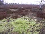 |
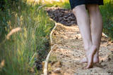
Baltijas mērogā unikāls dabas un cilvēkizmantots apvidus, kas veidojies kādreiz - padomju, mūsdienās - Latvijas Nacionālo bruņoto spēku pārvaldītā armijas poligona teritorijā. Poligona lielāko daļu aizņem smilšains vai ar zemiem lakstaugiem un krūmāju apaudzis kāpu masīvs ar atsevišķiem lielākiem kāpu vaļņiem. Rudens laikā šeit lielās platībās zied virši. Unikālā virsāju un aprimušo kāpu ainava un daudzu sugu dzīves vieta bija daži no iemesliem, kādēļ šai militārai teritorijai ir piešķirts arī aizsargājamas dabas teritorijas statuss. Jāatgādina, ka poligona apmeklējumi privātpersonām bez iepriekšēja saskaņojuma ir aizliegti!
|
|
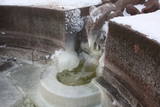 |
Построен на рубеже XIX – XX веков. Рядом, на правом берегу Вершупите находится один из самых популярных серных источников Латвии – «Ящерка». Родник вытекает из образующего форму ящерицы камня, который создан в 1949 году (скульптор Я. Баярс). Вода источника полезна как для внутреннего, так и наружного применения. Недалеко от павильона можно отыскать знак, указывающий на аллею Яниса Либиетиса. Я. Либиетис работал директором Государственного Кемерского учреждения серных источников с 1928 по 1944 гг. |
|
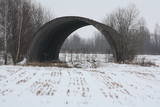 |
Кажется, что это одна из наиболее обвитых легендами в наши дни территория Советской армии,. В советское время здесь находился запасной аэродром, склады ядерного оружия (… 50 км от столицы), которые были замаскированы под два засыпанных землей и обросших растительностью ангара. В разных источниках можно найти сведения, что на складах хранились 430 кг термическая ядерная бомба RX – 24 и 1030 кг ядерная бомба RX – 26 с ядерными зарядами различного типа, а также ядерные ракеты типа земля-воздух. Что бы осталось от Риги и стран (стран Балтии? Северной Европы?), если бы здесь произошел несчастный случай? Сегодня аэродром - это закрытая территория.
|
|
 |
«Ягодный сад Сутру» расположен в Сутрусской волости Ливанского края. В хозяйстве выращивают клубнику и чернику. Ягоды выращиваются в туннелях, поэтому они созревают гораздо быстрее, чем где-либо еще в Латвии. Ягоды можно приобрести как на месте, так и в других торговых точках. |
|
 |
Находится в центре Вецстамериены, в 0,2 км к югу от Стамериенского замка. Обустроена в одном из исторических зданий господской усадьбы Стамериена со старинным интерьером. Латышская кухня: Холодный суп, свиной карбонад, тонкие блины. |
|
 |
Находится в центре Салацгривы на площади Боцманя, около Салацы. Когда-то столь известная корчма «У боцмана» приобрела новый интерьер, связанный с тематикой барона Мюнхгаузена. Латышская кухня: Салат из селедки, селедка с творогом, рыбный суп, свиная грудинка с луком, серый горох с салом, жареная печень, жареная камбала, жареное филе судака, слойка из черного хлеба. |
|
 |
The private museum of antiquities of Zigurds Safranovičš was founded in May 2010. The collection of the museum contains around 50 thousand objects, of which 99% of exhibits have been donated. The oldest and rarest, according to legend, 300-year-old item – Ernst Glick's refrigerator. The museum's surroundings are a large park of the former Baron Wulf's estate, where it is currently possible to spend the night in tents, as well as available rest areas - canopies, fire places, grills, utensils for cooking, etc., drinking water (from a well), available electricity for telephones, cameras, etc. for charging. For larger groups (starting from 10 people), porridge cooked on the fire. |
|
 |
Находится к югу от Кокнесе, на острове, который окружают воды Плявиньской ГЭС (соединен с берегом). Создан в память тех жителей Латвии, которые пострадали от тоталитарных режимов. Первые работы здесь начались в 2008 году. Автором художественной концепции является японский ландшафтный архитектор Шунмио Масуно (Shunmyo Masuno). Сейчас построено первое постоянное здание - Терраса видов, откуда открывается вид на развалины замка в Кокнесе и лютеранскую церковь. Каждый приглашается привести и оставить свой камень в этом значимом для нашего народа историческом памятном месте. |
|
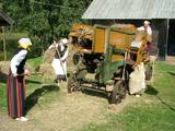 |
В 11 зданиях музея находится работающая во время свободной Латвии сельская техника, упряжь, несколько десятков двигателей внутреннего сгорания, орудия ремесленников и др. Ежегодно проводится Праздник жатвы, который собирает до 2000 посетителей. Для групп предлагают «Хлебную программу», во время которой посетители могут проследить ход становления хлеба от теста до буханки. |
|
 |
Interesanta dažāda vecuma ēku ieskauta gājēju ieliņa (gājēju daļa ~ puskilometrs), kura var novērot pilsētas arhitektūras stilu attīstību no 17. - 20. gs. Šeit tāpat kā citur Kuldīgā var apskatīt un nofotografēt pilsētai raksturīgos virsgaismas lodziņus un greznās un daudzveidīgās ēku durvis. Te vērts pasēdēt arī krodziņā! |
|
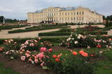 |
Рундальский дворец был построен как летняя резиденция Курляндского герцога Эрнста Иоганна Бирона по проекту выдающегося итальянского архитектора Франческо Растрелли. Строительство дворцового комплекса происходило между 1736 и 1740 годами, однако художественную отделку внутренней части замка с 1765 года по 1768 год осуществили скульптор Иоганн Михаель Граф, художники Франческо Антонио Мартини и Карло Цуки. Дворец важен своей аутентичностью, так как его не затронули перестройки более поздних времен. Интенсивная реставрация дворца была начата в 1972 году, когда был основан музей, а завершена в 2018 году. |
|
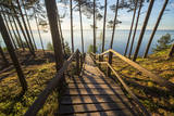 |
The trail reveals one of the rare bluffs of the Gulf of Riga – the Ēvaži Bluff (up to 15m high, a beautiful scenery opens from its watching platform) and the seashore forests. The trail starts from the main road and crosses a biotope “Wooded dunes of the coast” (according to Habitats Directive, Annex II), which is frequently observed by the sea. One can climb down the stairs to an extraordinary beach with narrow seashore and Black Alders growing almost in the sea. There are occasional puddles which make shelter for Natterjack Toad (Bufo calamita), a protected amphibian. Deeper pools are inhabited by three-spined stickleback (Gasterosteus aculeatus), they are food for fish-eating birds. In the second half of the summer, Common Shelduck (Tadorna tadorna) can be observed in the sea. About two kilometres to the South, there is Melnsils, one of the Liv fishing villages, famous for the stories about a channel which was once dug to drain coastal lakes into the sea, as well as about Trommel, the chief of robbers. The trail is in the Slītere National Park. |
|
 |
Один из необыкновенных городов Латвии, который как поселок торфяной фабрики образовался в 50 - 60 годах 20 века. Его планировали по «яркому» образцу советской архитектуры, с центральной площадью (с памятником вождя) и радиально уходящими улицами. Стоит увидеть Дом культуры (в конце улицы Узварас) - образец архитектуры сталинского классицизма. |
|
 |
Pirtnieka pakalpojumi, dažādi pirts rituāli. Viesiem ir iespēja iegādāties produktus no ārstniecības augiem - tējas, sīrupus, ziedes, salātus; tāpat arī piedalīties radošajās meistarklasēs tinktūru, masāžas eļļu gatavošanā. Informatīvā lekcija par augiem un pirti, pirts rituāliem. Klusā meža ielokā pieejamas telts vietas, piedāvājumā arī kubla noma un pārvietojamās pirts mucas noma. |
|
 |
На хуторе Сурвиласов, что расположен неподалеку от деревни Швейцария Йонавского района, можно почувствовать природу всеми пятью органами чувств, ведь здесь есть необыкновенная тропа для прогулок босиком, на которой гостя ждут и шишки, и топь, и торф, и глина, и гравий, и шлифованное стекло, и хвоя, и солома, и полоса препятствий, и много чего еще. Протяженность тропы составляет более километра, благодаря чему босоногий путник получает всю гамму неизведанных доселе ощущений, положительных эмоций и наплыв энергии. |
|
 |
Einer der ausgeprägten Kaps der lettischen Küste mit Niederungsauen und einem in 1875 gebauten Leuchtturm. |
|
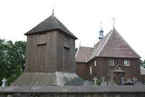 |
Iespaidīga koka celtne un izcils koka arhitektūras piemērs, kuru pamanīs katrs Plateļu apmeklētājs! Plateļu baznīca ir viens no Lietuvas vecākajiem koka dievnamiem. Pašreiz redzamais ir būvēts 1744. g., bet zvanu tornis – 1899. g. Dienvidos no baznīcas plešas Plateļu muižas parks. |
|
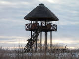 |
A island in the delta of Nemuna. Etnographical museum, Uostadvaris lighthouse, bird watching tower. |
|
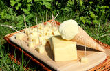 |
Кафе на летней террасе, которое находится на пляже пруда Прейльского парка, предлагает 100% натуральное домашнее мороженое с ягодами. На месте пекут свежие блины «Пампукас». Кафе работает только во время сезона со Дня матери (8-е мая) до Дня отца (11-е сентября). Для туристических групп предлагаются экскурсии и дегустация мороженого с сыром. |
|


