
| Нo | Название | Описание |
|---|---|---|
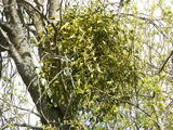 |
This is a mostly forested territory which is home to one of the largest areas of the white mistletoe, which is a semi-parasitic plant. It is best to observe this unique plant when it has no leaves. Latvia is the northern limit to the white mistletoe, which is why it is not all that common. It is interesting that even more of this rare specie can be seen outside of the nature restricted area. |
|
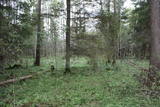 |
One of the rare places (see also Rucavas ivju audze) in Latvia where two rare and protected wild tree species grow - yew-tree and Baltic ivy. Territory is not marked on site with information signs or stands. Territory is not suitable for visitors as visitor without environmental knowledge will see “regular” forest. On the East side of the restricted area is located extending low wall – former narrow gauge railway (600 mm, length 41 km) line Dulbeni – Rucava. Railway was built by German military forces with the goal – to export wood.
|
|
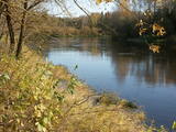 |
Teritorija, kas aptuveni 20 km garumā „piekļāvusies” abiem Aiviekstes upes krastiem. Dabas parka galvenā vērtība ir palieņu pļavas (un citi pļavu biotopi), kas ir ļoti nozīmīga daudzu augu un dzīvnieku (īpaši – putnu) sugu dzīves vieta. Ūdenstūristiem, kas laivo pa Aivieksti, nakšņošana ir jāplāno tikai šim mērķim paredzētās vietās!
|
|
|
|
Latvijai neparastā izskata tornis tika uzcelts līdz ar Ziemeļblāzmas kultūras pils un parka atjaunošanas procesu. No torņa paveras plašs apkārtskats uz jau minēto parku, pili, Daugavu, Pārdaugavu un Daugavas vārtiem (Daugavas ieteka jūrā). Darbojas lifts. Tornis atvērts sezonas laikā. |
|
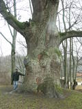 |
This tree is in the park of the Sēja Estate and is one of the four trees in Latvia that have a circumference of more than four metres.
|
|
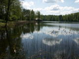 |
Lake Salājs is full of bays and islands. Alongside Lake Little Solojs, which is next to Lake Salājs, is the Milka castle hill and a leisure facility there. This is a beautiful area, and it is protected for environmental purposes. |
|
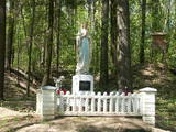 |
Городище Милкас находится на северном берегу залива западной
части озера Салайс, неподалеку от истока реки Малты. Гора поднимается
на 27 м над уровнем озера. Склоны городища крутые одинаково, только
восточная сторона более покатая. Местный предприниматель привел в
порядок городище и установил на нем статую Богоматери, свидетельству-
ющую о вере местных жителей Богоматери и убежденностью в существование Бога.
|
|
 |
Riežupes dabas parks veidots g.k. Riežupes izteksmīgās ielejas, tai raksturīgo dabas vērtību – nogāžu un gravu mežu, dažādu ģeoloģisku dabas pieminekļu - smilšakmens atsegumu, alu, ūdenkritumu, upes straujteču posmu, dažādu sugu, mežu masīvu un ainavas aizsardzībai. Parka atrodas viens no Kurzemes populārākajiem tūrisma objektiem – Riežupes alas - garākais mākslīgo alu labirints Latvijā, kura eju kopgarums ir 460 m. Sākotnēji dabas veidotās alas 19. gs. vidū mākslīgi paplašināja baltās smilts ieguves nolūkos, kuras izmantoja stikla ražošanai. Parkā izveidots velotūrisma maršruts. |
|
 |
Labiekārtota (informācijas stendi, atpūtas vietas) un marķēta taka, kas ved apkārt Kokšu ezeru virknei, kurā ietilpst Zāļu, Dziļais un Dibena ezers. Iepazīstami mežu biotopi, dzīvnieki un to darbības pēdas. Iespējami trīs dažādi takas izziešanas varianti: 7 km, 4,5 km, 2,7 km. Maršrutu var braukt ar divriteni. Ietilpst Ziemeļvidzemes biosfēras rezervātā. |
|
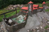 |
Науенское городище находилось на крутом правом берегу долины Даугавы на высоте 25 м, между двумя оврагами. Под руководством магистра Ливонского ордена Эрнеста фон Раценбурга в 1275 - 1277 гг. на месте прежнего латгальского деревянного замка возводится каменный замок. До середины XVI века замок служит резиденцией комтура Динабурга. В 1577 году войска Ивана Грозного полностью разрушили замок. После этого события Динабург теряет свое стратегическое значение, и строительство новых укреплений начинается в том месте, где сейчас находится Даугавпилс.Рядом с развалинами замка ордена установлен уменьшенный макет замка. С места автостоянки до городища можно дойти по тропе. С городища открывается один из красивейших видов на изгибы Даугавы. |
|
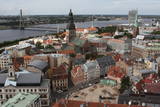 |
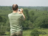
St Peter’s is one of the oldest historical monuments in the Baltic States, and it is also the best place from which to survey the historical centre of Rīga, which is part of the UNESCO list of world cultural heritage. You can see the central part of Old Rīga, City Hall Square, the Pārdaugava region on the opposite side of the river, and even – during clear weather – the Bay of Rīga. The tower of the church is 123 metres high, but the viewing location is at a height of 72 metres.
|
|
 |
Тропа создана на склоне основного берега древней долины реки Абава, где можно осмотреть рассредоточенное выклинивание подземных вод, различные типы лугов, можжевельниковые поляны и др. На береговом склоне весь год „хозяйничают” дикие коровы. 200 ступеней приведут вас к вершине берега древней долины, с которой открывается великолепный вид. Тропу рекомендуется посещать в сопровождении местного гида. |
|
 |
The tower on the eastern shore of Lake Engure (next to the meadow for wild cattle, accessible from the side of Bērzciems) offers a view of the reeds, small islands, Great Island, cows and horses of the north-eastern part of the lake. The tower on the northern shore of the lake (accessible from the side of Mērsrags) offers a look at the boating facility and the very overgrown northern part of the lake. The tower at the north-western shore of the lake (accessible from the side of Ķūļciems) shows the Apaļrova island (a footpath), stands of juniper, the boating facility, and the mosaic-like landscape of the lake itself.
|
|
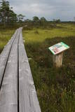 |
The trail informs visitors about one of the loveliest natural habitats in
|
|
 |
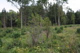
The forests of Zvārde are located on land which used to be a Soviet air base. The territory was unpopulated and was not accessible to civilians. The vast area includes various types of forest - boreal forest, bogs of black alder, etc. The fact that the military used to control the territory is one of the reasons why the forests of Zvārde are a location where many rare and protected birds live, reproduce and find food. Some of the elements of the old air base are still in place, including a unique surveillance platform. It is recommended that visitors to the area drive only along general use roads. |
|
 |
One of few places in Latvia (around 1 km to the North from Lapmezciems) where used to be beautiful juniper meadows. Since no agriculture activity (grass cutting, cattle grazing) has been implemented in the area, juniper meadows are overgrowing and disappearing. To save the area sustainable management is needed. Slitere National Park with Blue Mountain cliff and Slitere lighthouse is located in short distance from Kadiku nora (Juniper meadow).
|
|
|
|
Opekalns (arī Apukalns, Opekols) ir paugurs Alūksnes augstienē, 235 metrus virs jūras līmeņa, Veclaicenes pauguraines viena no augstākajām virsotnēm. Tā virsotnē uzcelta Opekalna luterāņu baznīca (1774—1779), kas ir visaugstāk virs jūras līmeņa novietotais dievnams Latvijā. Opekalna ciemā dzimis leģendārais Dziesmu svētku virsdiriģents Haralds Mednis. |
|
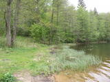 |
The most important aspect of the Sasaļi forest is the eutrophic Lake Sasalis, as well as the unusual Lake Melnezers. Also of importance are various types of forestland in the area. Lake Sasalis is a popular place for leisure and swimming.
|
|
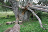 |
This is certainly the thickest White Willow (Salix alba) in Latvia and perhaps the thickest one in the Baltic States. Many of its mighty branches are resting on the ground, and the enormous monolithic trunk has been split. There’s a small information stand alongside the tree. A pathway which starts at the Raganu cliffs can be taken to the tree.
|
|
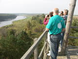 |
Старая деревянная башня была снесена, и на ее месте сейчас построена новая вышка. С построенной в 2015 году вышки открывается один из самых красивых природных видов Латвии, который в свое время был изображен на 10-латовой банкноте. Вид на эту излучину Даугавы считается самым красивым на протяжении всего течения реки. |
|


