
| Нo | Название | Описание |
|---|---|---|
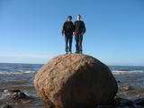 |
Covered with rocks and with small capes and inlets, this is the eastern shore of the Bay of Rīga and the only place in Latvia where sandstone outcrops are found. These are the result of the abrasive effects of waves between Tūja and Vitrupe. Among the most distinguished of these outcrops are the Veczemi cliffs, which are less than half a kilometre long and up to four metres high. The area has been improved for tourists. It has to be said that this part of the shoreline changes very often, particularly after large storms.
|
|
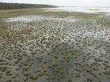 |
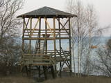
The tower on the eastern shore of Lake Engure (next to the meadow for wild cattle, accessible from the side of Bērzciems) offers a view of the reeds, small islands, Great Island, cows and horses of the north-eastern part of the lake. The tower on the northern shore of the lake (accessible from the side of Mērsrags) offers a look at the boating facility and the very overgrown northern part of the lake. The tower at the north-western shore of the lake (accessible from the side of Ķūļciems) shows the Apaļrova island (a footpath), stands of juniper, the boating facility, and the mosaic-like landscape of the lake itself.
|
|
 |
Памятник природы - охраняемые дендрологические насаждения «Парк Варкавас» - расположен в Упмальской волости, и его площадь составляет 2,7 га, является охраняемым с 2001 года; территорией управляет Варкавский областной совет. Парк был разбит в конце 19-го века, судя по самым большим дубам (приблизительно 200-летним), остальные насаждения были проведены в конце 19-го века. В парке растут местные сорта кустарников и деревьев - клены, ясени, ели, осины, дубы, нежная ива, липы, вязы, лещина, бересклет европейский, черемуха и др., а также более 10 экзотических видов деревьев и кустарников, наиболее значимые из которых - клен остролистный, клен сахарный, чубушник пушистый, душистая осина, серебряная ива, Венгерская сирень, Крымская липа, липа широколиственная. |
|
|
|
No 28 m augstā torņa, kas atrodas uz apdzīvotas „salas” – Siksalas Teiču purva vidū, paveras ļoti plaša augstā purva ainava ar Siksalas ezeru, citām minerālzemes salām un Siksalas mazciemu. Tā kā tornis atrodas Teiču dabas rezervātā, to var apmeklēt tikai Dabas aizsardzības pārvaldes inspektora pavadībā, iepriekš piesakot vizīti T: + 371 28333415. |
|
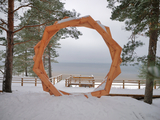 |
A new section of the walking trail along the sea has been built and an environmental object "Sunset watcher" has been created in Saulkrasti near the White Dune and Sunset Trail. It is a photo object where the newlyweds and every guest of Saulkrasti can capture memories in the symbol of the sun, which is so characteristic of Saulkrasti. |
|
|
|
Uzcelts Kaņiera pilskalnā un ir Kaņiera pilskalna takas sastāvdaļa. No torņa paveras izcila Kaņiera ezera dienvidrietumu daļas ainava ar niedru saliņām un nelieliem atklāta ūdens laukumiem. Laba putnu vērošanas vieta. |
|
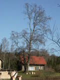 |
This is the thickest birch (Betula pendula) tree in Latvia and can be seen from the Klapkalnciems-Milzkalne road.
|
|
 |
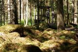
These are hillocks at the northern end of the Vidzeme highlands, and this is an important location for boreal (Northern) forests and swamps. Various kinds of swamps are found here, and the area is home to a variety of protected invertebrates.
|
|
 |
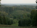
This is a view worth a journey from a distance. This is an impressive terrain for Latvia, and here you will see as far as the Hanja highlands of Estonia, where the Great Munameģis Hill – the highest surface in the Baltic States – can be found.
|
|
 |
In Dagda, on the side of Daugavpils Street, there is a forested hillock that is the Lubāne castle hill. On the upper part of its southern side, there’s a viewing area which offers a view of the small Lake Lubenenis, the eastern part of Dagda, and the white tower of the local Catholic church. Legend has it that treasure is buried here.
|
|
 |
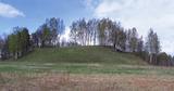
From the highest point in the Alūksne highlands, you will see an unusually beautiful view of the surrounding forested hillocks and the small areas of meadows and farmland. Sadly, there are no improvements to the location, which can be difficult to access. It is on private property.
|
|
 |
В Калтенском лесу можно увидеть овитое преданиями чудо природы – Калтенские калвы или Валовые калвы. Происхождение нагромождений камней в в лесу в 2–3 км от моря связано с береговыми образованиями Балтийского ледникового озера. Велна калва – самое большое нагромождение. В свое время Велна калва было красивым нагромождением камней, такое огромное, что «достигало верхушек деревьев». На более ранних картах обозначена абсолютная высота нагромождения над уровнем моря – 20 м. В нагромождении было много камней своеобразной формы. Среди них много полностью шарообразных, а также камней тарельчатой формы. Это нагромождение почти полностью было разрушено в 1960 – 1970 годах, раздробив камни на щебень для строительства дорог. До наших дней осталась только относительно небольшая нижняя часть нагромождения, длина которого примерно 300 м, а высота 2 м. Ученые высказывают также мнение, что калвы в древности могли быть святыми местами, так как о них сохранилось много преданий. Для осмотра оборудована благоустроенная природная тропа с мостками, информационными стендами и небольшой площадкой для стоянки автомашин. (Источник: Ройский ТИЦ) |
|
 |
Aptuveni 0,5 km dienvidos no Mežotnes pilskalna atrodas Vīna kalns, kas līdzīgi kā Mežotnes pilskalns, ir veidots, izmantojot Lielupes ielejas stāvās krastu nogāzes, tās pārveidojot. Vietvārds ir it kā radies no stāsta, ka šeit parādījies dievgalds ar maizi un vīnu. Vīna kalnu ar Mežotnes pilskalnu savieno jauka koka laipa, kas ved pa Lielupes ielejas pamatkrasta lejas daļu. |
|
 |
Городище Спринги pасположено недалеко от города Резекне и
вызывает интерес своеобразной формой. Археологический
памятник местного значения.
|
|
 |
Kartavkalnā, kur senāk atradusies seno zemgaļu apmetne, ir izveidota dabas taka ar soliņiem, piknika vietām. Šeit apskatāms arī Jaunpils Kartavu kalns un lapegļu aleja, kā arī iespējams aplūkot, kāda izskatās senlatviešu apmetne ar īstu guļbaļķu sētu.
|
|
 |
This tower is on the shores of the ancient Litorine Sea, with a lovely view of the unique seashore here – complete with small bays and capes. It is part of the Kaltene nature trail, which is around one kilometre long. The location is of particular interest during spring or autumn migration of birds. Two other bird-watching platforms are nearby.
|
|
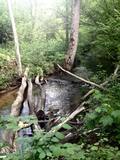 |
Длина тропы составляет около 1,2 км. Уникальной тропу делает холмистый рельеф леса (глубина оврагов местами достигает 15 м), разнообразие видов растений и живописные изгибы Каулиньупите, пересекающие тропу в двух местах. Тропа Жибгравас была создана в конце 90-х годов. |
|
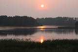 |
Also known as Lake Jēsis or Lake Iesis, this is the lake in Latvia which has the largest number of islands. Many literary sources and encyclopaedias in the 20th century claimed that there were 69 islands in the lake, but that was an exaggeration, because apparently the authors took sandbars overgrown with reeds and other plants to be islands. The true number is approximately two times lesser. The largest number of islands can be found in the north-eastern part of the lake. The largest one is Lielā Lāča (Big Bear) Island (45 ha). A farm was on the island at one time. The islands and the oak trees that are on the shores of the lake – the Piļoru and Pahatnīku stands of trees – are in a restricted environmental reserve. |
|
 |
Городище Бусе (Маткулес) находится в изгибе берегов реки Имула. С него, на противоположный берег Имулы открывается один из самых живописных видов на речушки Курземе. Видом лучше всего любоваться в безлистный период, когда ландшафт не закрывает береговая растительность. С правого берега великолепный вид на долину Имулы открывается также по дороге к городищу рядом с домом Бусе. |
|
 |
Ģeoloģiskā taka sastāv no trīs saistītiem posmiem: „Melturi – Kārļu zivjaudzētava”, „Kārļu zivjaudzētava – Zvārtes iezis” un "Zvārtes iezis - Veclauču tilts". Amatas senleja veidojusies vienlaikus ar Gaujas senleju leduslaikmeta beigu posmā un pēcleduslaikmetā, ledāja kušanas ūdeņiem plūstot uz Gaujas ieleju. Gaujas NP teritorijā Amatas senielejas dziļums sasniedz 50 metrus un platums palielinās līdz apmēram 1-1,5km.
Augstas kraujas (vairāk ne kā 40 metru), kurās redzami augšdevona Pļaviņu svītas dolomītu un augšdevona Amatas un Gaujas svītu smilšakmeņu atsegumi, mijas ar mežiem apaugušām, 3-16m augstām stāvām terasēm.
Amatas senieleja ir nozīmīga ne tikai ar savām dabas ainavām. Tās krastus grezno dolomīta un smilšakmens atsegumi, kas atklāj zemes vēstures lappuses 350-400 miljonu gadu tālā pagātnē, kad Latvijas teritoriju klāja jūra.
Velobraucieniem taka nav piemērota!
|
|


