
| Нo | Название | Описание |
|---|---|---|
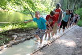 |
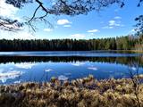
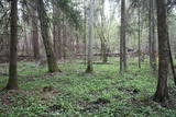
The first barefoot trail created in the Baltic States in the recreation complex "Valguma pasaule", which is located on the forested shores of Lake Valguma. When walking on the path, the feet "massage" sand, wood chips, clay, peat, gravel, cones and various other materials. |
|
 |
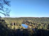
This is one of the most lovely and expressive castle hills in Latvia, with a very fine view of territory all the way to Lithuania. According to Ernests Brastiņš, a researcher of castle hills in Latvia, this was the site of the Semigalian Sidrabene castle. There are no improvements in the area.
|
|
 |
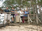
Koka skatu tornis atrodas blakus Kolkasraga priežu takai. No tā redzama ar priedītēm aizaugusi „stiga” – t.s. Šautuve, kuru padomju laikā izmantoja šaušanas apmācībām. No torņa skatu platformas labi saskatāma Kolkas bāka, kas atrodas 5 km attālumā no Kolkasraga. |
|
 |
1,8 km garā taka atrodas neparastā vietā – uz Cirīša ezera salas. Tās galvenās vērtības ir augu valsts un dzeņveidīgo putnu daudzveidība. Viens no apskates objektiem ir Upurkalns – sens pilskalns. Taka labiekārtota, izveidoti informācijas stendi, atpūtas vieta. Lai nokļūtu uz salas, no vietējiem jānomā laiva, vai jādodas ar savējo. Atrodas dabas parkā „Cirīša ezers”. |
|
 |
This is one of the most impressive and extensive natural structures of its kind in Latvia in terms of appearance and landscape. The ice age left behind this wall-like terrain, which is up to 27 metres high and at the top of which the Rīga-Ērgļi road has been built. The Great Kangari hills offer a view of the Great Kangars lake and the Great Kangari swamps and ponds. The Ķoderi castle hill, also known as the “Big Man’s Bed” is found here. The restricted area was established to protect the structure and its related biotopes and plants.
|
|
 |
Ķekavas novadā, Daugmales pagastā atrodas jauka atpūtas vieta - Lejas ezers. Ezeram var apiet apkārt, taka nav marķēta un iešana ir pa mazām meža taciņām. Slapjākā laikā taciņas vietām var būt mitras un dubļainas. Pastaiga aizņems aptuveni stundu. Pie ezera ir iekārtotas vairākas piknika vietas. |
|
|
|
Atrodas Sedas purvā (Sedas dabas takas malā) ar plašu skatu uz izstrādātajām kūdras platībām. Sedas taku ieteicams izstaigāt vietējā gida pavadībā T: + 371 2636162. |
|
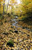 |
The lime gully that emerged as the Baltic ice lake receded is crossed by the powerful streams of Mežmuiža, and the water from these streams contains a high concentration of lime salts. The water from the streams flows into a mill pond that has a very interesting colour. The sculptor Teodors Zaļkalns once lived in the travertine mill that is alongside the pond. Wood pathways have been installed for those who wish to visit the streams.
|
|
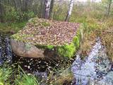 |
Широкий камень. В волости Маконькалнс, недалеко от камня
Ажмугурас, на краю небольшого болота спит Широкий камень. В
отличие от своего соседа – плоский. Вокруг обоих камней завито
много рассказов. Один гласит, что камень Ажмугурас – часть
Широкого камня, а также, что накопившаяся дождевая вода во впадине Широкого камня может лечить
бородавки.
|
|
 |
On the left bank of the Gauja River, opposite the Piķene cliff is the mighty Beite cliff which is split by a deep ravine. On the left side there is Ķeizarskats (Emperor's View), which is approximately 67 metres above the level of the Gauja and offers a fine view of Krimulda and the Turaida Castle. The viewing place was installed in 1862, when Russian Tsar Alexander II visited Sigulda. On the right side of the ravine is the mighty wooden Ķeizarkrēsls (Emperor's Chair). To get there, you have to cross the ravine (there are wooden stairs and a forest trail). You can go around it on Laurenču, Kalna and Gulbju streets. |
|
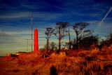 |
Akmensraga tāpat kā Kolkasraga apkaime jau kopš seniem laikiem ir bijusi zināma kā kuģotājiem bīstama vieta, jo te atrodas viena no lielākajām Latvijas piekrastes kuģu kapsētām. Bīstamības fakts slēpjas apstāklī, ka Akmensraga apkārtnē mainās krasta virziens un jūrā iestiepjas akmeņaini sēkļi. Pirmo signāluguni Akmensragā iededza 1879. g., bet 10 gadus vēlāk uzcēla 28 m augstu koka bāku. 1911. g. uzcēla mūra bāku, kuru sagrāva 1. pasaules kara laikā – 1916. g. Mūsdienās redzamā (augstums 37,5 m, uzbūvēta 1921. g.). Padomju laikā visas bākas bija militāri – stratēģiski objekti un šeit strādāja hidrogrāfiskais dienests un jūras novērošanas punkts. Bākas apkārtnē - mežā vēl joprojām redzamas bijušās padomju armijas ēku drupas. Apskatāma no iekšpuses. |
|
 |
This is a route for hikers and bicyclists, starting at the village of Vaidava and then moving along the eastern shore of the narrow Lake Vaidava, which has steep cliffs around it. The trip covers the Veļķi baronial estate, the “Swedish pine”, the famous Vaidava (Metimne) hillfort, a series of streams, the great Rubene rock, the Vaidava baronial estate on the western shore of the lake. After that, the trail leads the visitor back to the starting point.
|
|
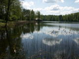 |
Lake Salājs is full of bays and islands. Alongside Lake Little Solojs, which is next to Lake Salājs, is the Milka castle hill and a leisure facility there. This is a beautiful area, and it is protected for environmental purposes. |
|
 |
Болото Бажу – самое большое болото в Слитерском национальном парке –
зона строгого режима, нахождение в которой запрещено.
|
|
 |
One of the rare places (see also Rucavas ivju audze) in Latvia where two rare and protected wild tree species grow - yew-tree and Baltic ivy. Territory is not marked on site with information signs or stands therefore it is hard for visitors to find. Not usable as tourism object.
|
|
 |
Rīgas – Daugavpils šosejas (A 6) malā (vietā, kur no Zemkopības institūta nogriežas ceļš uz Skrīveriem) redzama zema ieplaka ar Kraukļu akmeni, kas ir sena kulta vieta. Pie akmens veikti arheoloģiskie izrakumi, kuru laikā atrastas senlietas. Vecākā ir no 12. gadsimta. Akmens aprakstīts slavenajā Andreja Upīša (1877. – 1970.) darbā „Sūnu ciema zēni”. |
|
 |
The trail climbs up and down along the bluffs of lower River Pilsupe and reveals a fascinating sight of three white dune exposures (the largest is called the White Dune). The dune range has formed in the period of the Littorina Sea several thousands of years ago. The time required to walk the trail is ~0.3 h. Evidence of Stone Age settlements have been found in the vicinity. |
|
 |
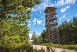
The wooden tower was built and stands 28 metres high. It is at the top of the highest hillock of the Northern Courlandian Highlands – Kamparkalns Hill (175 metres above sea level). The tower offers one of the loveliest views in the region of the hillocks of Talsi. On a clear day, you can see all the way to the Bay of Rīga and Talsi. |
|
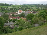 |
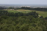
Известное еще со времен Курземского герцогства как самое северное место, где выращивали и делали кисловатое вино герцогства. С 1999 г. ежегодно, во второй половине июля, в Сабиле проходит Праздник вина. С Винной горы приоткрывается прекрасный вид на провинциальный город, который расположился на берегах древней долины Абавы. |
|
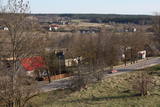 |
We recommend that you walk through the town of Kandava not only to enjoy the charm of a small town, but also to find fantastic viewing locations where you can see the town and the shores of the ancient Abava River valley from the Kurši (Ancestor) castle hill, Lielā Street, the Bruņinieki castle hill and Zīļu Street (School Hill), as well as from the area of the Ozolāji open-air stage.
|
|


