
| No | Name | Description |
|---|---|---|
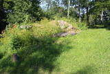 |
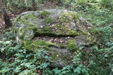
The Lašu castle hill is 0.2 km from the Vecumnieki-Ilūkste road at Laši. It is an ancient Selonian castle hill, and it was populated between the 1st millennium BC and the 10th or 12th century. Very little remains of the old Veclaši (Tiesenhausen) Estate, which had an impressive mansion designed in the Neo-Gothic style in the late 19th century. What remains are an ancillary building, the foundations of the mansion, fragments of the gates, and a park. Until 1920, the estate belonged to the Pshezdzetski dynasty, and before that it was owned by the Tiesenhausen and Fittinghoff dynasties. Before visiting the location, look for photographs of the old mansion on the Internet. Sadly, the important cultural monument has not experienced any major improvements over the past 20 years.
|
|
 |
Eine der größten befestigten Siedlungen im Bezirk Harju, befindert sich auf einer Erhebung des natürlichen Kliffs Nordestlands. |
|
 |
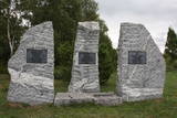
A monument to the founders and
directors of the Ķemeri spa (1861) on the
banks of the Vēršupīte.
|
|
 |
Atrodas Tērvetē, Dobeles – Elejas ceļa malā, 0,2 km dienvidrietumos no Tērvetes pilskalna. Ar mežu apaugušais paugurs ir sena apmetnes vieta, kas bijusi apdzīvota jau 1. g.t. pr. Kr. Teika stāsta, ka kalnā bijis klosteris, kura mūki pēc klusēšanas pārkāpuma saulgriežu laikā kopā ar visu celtni nogrimuši kalna dzīlēs. |
|
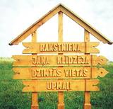 |
„Upmaļi” is the family house of writer Janis Klīdzējs who has written 8 novels, 11 storybooks, 2 essay books
and reflections about Latgalian catholic-Latvian mentality. Janis Streičs (famous Latvian film director) shot a film
based on the novel of Janis Klīdzējs called „The Child of a Man”.
|
|
 |
During the latter half of the 19th century, one of the largest ship building facilities was located here between the Dzeņi and Lielkalni homesteads. It was known as the Ķirbiži and then the Vitrupe shipyard, though nothing remains of it. 28 ships were built here between the 1860s and 1929. |
|
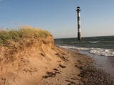 |
Harilaidas galā no jūras ūdens paceļas 26 m augstā Kīpsāres bāka – viena no neparastākajām Igaunijas bākām. Tā celta 1933. g., kad jūra no bākas atradās ~ 100 m attālumā. Krastu noskalošanas rezultātā tā tagad ir viļņu ieskauta. |
|
|
|
Der Turm war der Eckturm der mittelalterlichen Stadtmauer von Pärnu. Der Turmhof ist ein beliebter Ort für Kunsthandwerkermärkte und ein Veranstaltungsort. |
|
|
|
The Smārde saloon has a very long history,
and food is served here. There is a car park, and
approx. 100 m to the East is a cemetery and
monument to commemorate soldiers who fell
during World War II.
|
|
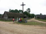 |
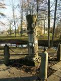
Ein der ethnografischen Dörfer in Dzūkija mit Holzgebäuden und Kruzifix. |
|
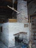 |
In Metsanurme Village Centre you can see restored old threshing barn, limestone barn oven and few tools that were used ages ago. You could be also interested in seeing an outdoor exhibition which focuses on historical agricultural tools. All of this is made to look interesting to not only locals but also visitors. |
|
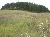 |
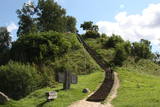
This partly forested hillock stands 40 metres above the surrounding area and offers impressive views. The fact that this was once a castle hill is attested by the presence of a moat and remnants of defensive fortifications. It is thought that Lettigalian tribes settled here in the 10th century AD. You can climb the hillock to take a look at the surrounding landscapes. |
|
 |
The remnants of the Vardīte sulphurous
spring – not easy to find, but the location is
between the Forest House and the Ķemeri
Hotel.
|
|
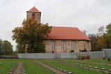 |
The graveyard that is alongside the Lestene Lutheran Church is the final resting place for more than 900 soldiers who fell during World War II, particularly during battles at the so-called Fortress of Kurzeme, as well as in Zemgale and Vidzeme. The sculptress Arta Dumpe designed the commemorative monument “Mother Motherland – Latvia.” The cemetery of the brethren is the second largest resting place for soldiers from World War II after the Cemetery of the Brethren in Rīga. The names of some 11,000 soldiers are engraved on the gravestones. |
|
 |
A place fraught with many legends and ghost stories about the old burial mound at the church of Mazirbe, an ancient tomb covered by stones– the only known grave of warewolves in Latvia. |
|
 |
Near Mākoņkalns hill there is a trail that is mowed in the summer and leads to several historical rocks – Plakanais (Flat) rock, Āža muguras (Ram's Back) rock (on which you can clamber), and the Jaunstašuļi Velna pēdas (Devil's Footprint) rock, on the surface of which is a shape similar to a human footprint. There are signs along the side of the road leading to the trail. |
|
 |
Eine der ältesten Ortschaften Litauens. Schon im 14. Jh befand sich hier eine Holzburg. Der 20 m hohe Merķine-Burgberg an der Mündung der Flüsse Merkys und Nemunas. |
|
 |
Musteikas pirmsākumi ir meklējami jau 18. gs. Līdz Musteikai no Marcinkones puses var nokļūt pa grantētu ceļu, kas ved gar bijušajiem kolhoza zivju dīķiem. Automašīnu var atstāt ciema sākumā un izstaigāt to ar kājām, izjūtot veco ēku smaržu un šarmu. Musteikā atrodas Dzūkijas biškopības vēsturei veltīts „dzīvs” muzejs, kur stropos dzīvo bites, bet tā saimnieks ir biškopis pēc aicinājuma un būtības. Ja palūgsiet, viņš demonstrēs – kā ar krama, metāla un posas piepes palīdzību senos laikos ieguva uguni. |
|
 |
This may be an ancient cult object, and today it is a little hill in the dunes that is a bit larger than other local hills. It is said that a church once sank into the dune. This tale suggests that there was a Christian or pagan prayer place here at one time. (Source: Roja TIC) |
|
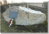 |
The memorial stone to Augusts Muižulis,a recipient of the Lāčplēsis Military Order, is placed in the Lapmežciems, at the edge of the road (P 128, Jūrmala-Talsi) at the marker for the 9th kilometre. A. Muižulis, (189 –1941) was a lieutenant colonel in the No. 4 Valmiera Infantry Brigade. The adjacent Tuteņi homestead is his native home. |
|

