
| No | Name | Description |
|---|---|---|
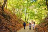 |
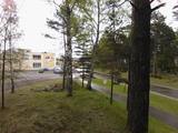
Šis ir viens no retajiem ceļiem, kurš saglabājies kā notikumu liecinieks. Ceļš ved no Krimuldas uz Siguldu. Jau vācbaltu apgaismotāja novadpētnieka – mākslinieka Johana Kristofa Broces 1794. gada zīmējumā "Siguldas un Krimuldas pilsdrupas" redzams lauku ceļš gar Krimuldas pili, pa kuru iet zemnieks un darba ratus velk zirgs. Lai braukšana pa Gaujas senlejas nogāzi ar zirga pajūgu būtu droša, ceļu izveidoja līkloča formā, tā uzbrauktuvi padarot daudz lēzenāku. Domājams, ka ceļš atjaunots 19 gs., kad Krievijas cars Aleksandrs otrais un viņa sieva ieradušies uz vizīti siguldā. Pāri ceļam bijuši vairāki mazi tiltiņi, ko iedzīvotāji dēvējuši par velna tiltiem. Tagad serpentīna ceļš kļuvis par romantisku pastaigu vietu. |
|
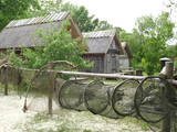 |
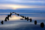
This is a very interesting monument to the history of fishing in the region. These areas had docks and areas where fishermen built huts to store their nets and other inventory. The areas also had a social role – men came together to discuss work that had to be done, while women and children wove nets. The huts at Bigauņciems were eventually washed into the sea, and the areas at Ragaciems have been partly destroyed. The ones at Lapmežciems are the ones which are best preserved. One of the net huts has been restored, but the others are in very poor condition, indeed. That may be why you should focus on these huts as you walk along the beach. Make sure that you take some pictures of this historic location. |
|
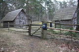 |
Approximately 200 metres to the North-East from the Liv People's Centre, along the Mazirbe-Košrags road, there is the Seppes homestead. The little log granary was built in the 1920s and 1930s by an Estonian fisherman and builder who arrived in Mazirbe from Saaremaa. He was called Jēkabs Jaga. On the other side of the road is the Kalši home, which was built in the early 20th century. It has been restored, but the bricks that were made in a local kiln were preserved for its walls. |
|
 |
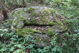
Atrodas 0,5 km ziemeļaustrumos no Dzērbenes baznīcas, ceļa otrajā pusē. Vizuāli izteiksmīgs pilskalns ar 50 x 50 m lielu plakumu, kura kultūrslānī atrastas vēlā dzelzs laikmeta apmetnes atliekas. Pilskalna rietumu nogāzē ir izveidots ceļš, pa kuru nonāksim līdz tā plakumam ar estrādi. |
|
 |
Near Mākoņkalns hill there is a trail that is mowed in the summer and leads to several historical rocks – Plakanais (Flat) rock, Āža muguras (Ram's Back) rock (on which you can clamber), and the Jaunstašuļi Velna pēdas (Devil's Footprint) rock, on the surface of which is a shape similar to a human footprint. There are signs along the side of the road leading to the trail. |
|
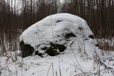 |
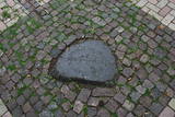
The historic stone, on which there is carved over 200 years old boundary-mark, sets the border between the Duchy of Courland and the Russian province. Nowadays, it sets the Babīte and Jelgava district boundary. The stone lies to the East of Kalnciems–Peat road (the south of the swamp Labais purvs) at the edge of a forest firebreak and it can be hard to find. To this end, the description of the road map may help: around 400 m south of the car parking lot at Lily Lake from Kalnciems-Peat road to the right (in the east) turns a forest road which leads down from hills Krāču kalni. It should be around 170 m to go until it abruptly turns to the right (to the southeast). Then you must go in this direction until after ~ 0.5 km to turn to the northeast where after further ~ 0.4 km of the current forest road intersection turn to the north. After ~ 0.4 km turn right (to the east) on a big firebreak, on the left (the north) side of which behind the drainage ditch during the non-leaf period there can be seen a rounded stone. Due to the poor condition of roads, the stone can be reached only on foot. |
|
 |
Kaltene features several homes where shipbuilders used to live – Caurnāši, which was home to the Bertliņi family, Ilmati, where six ailing ships were built, Maizītes, where the Stahl family of ship builders built 16 two-mast and three-mast ships, and Dambekalni, which was once one of the first canned fish factories on the coastline. To the side of the sea are the old boat piers of Kaltene. In 1936, a board pier was built by the Freijs family from Roja. It was 200 m long and had room for some 50 boats. All that is left are wooden poles that have been eaten away by the sea and time. If you want to learn about the specifics, difficulties and challenges of fishermen today, visit Ervīns Vilciņš in Ķirķrags. He will tell interesting stories on the basis of his experience. You can watch as he fishes in the morning and then taste the fish that he has caught. (Source: Roja TIC) |
|
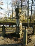 |
A monument to the founders and
directors of the Ķemeri spa (1861) on the
banks of the Vēršupīte.
|
|
 |
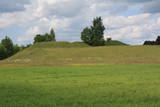
The castle hill is an island in the reservoir of the Pļaviņas hydroelectric power plant, and it can be accessed by boat. The ancient Selonian castle hill was settled several times between the 6th and the 12th century. This was the political and military centre of the Selonian region. In 1373, the Livonian Order built a stone castle on the hill, as it did on many other ancient hillocks. The castle was sacked in 1704 during the Great Northern War. Remnants of a square tower, a guard room and the 12 m embankment that once protected the castle are all that survive. Approximately 300 m to the North of the Sēlpils castle hill is Oliņkalns hill, which is underwater. |
|
 |
Neliela apdzīvota un ainaviska vieta plašajā Skrobļa (Skroblus) strauta ielejā. Ciema austrumu pusē atrodas Lietuvas mērogā unikāls objekts – klēts - rija, kur no 1929. g. vietējie cilvēki uzveda un skatījās lauku teātra izrādes. Netālu no tās (uz abiem objektiem ir norādes) atrodas Skrobļa avoti (Skroblaus versmės), kas iztek no dziļas starppauguru ieplakas. Avotu gan ir appludinājis bebru uzceltais dambis. Dienvidos no ciema atrodas vecs grants karjers, kas ir viena no retajām vietām Baltijā, kur dabā ir atrodami krama ieža gabali, kas atnesti ar ledāju. |
|
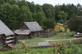 |
Grūti iedomāties, ka vēl joprojām Eiropā ir apdzīvotas vietas, kuru sasniegšanai ir labu laika sprīdi jābrauc pa neapdzīvotu mežu ieskautu smilšainu ceļu, kur tikai paretam var redzēt kādu sēņotāju vai ogotāju! Tāpat kā Zervinos ciemam, arī šim ir piešķirts kultūras mantojuma pieminekļa statuss, jo Linežeris ir viens no dažiem nacionālā parka etnogrāfiskajiem ciemiem. Linežerī ir aplūkojamas 19. – 20. gs. mijā celtās ēkas un apskatāms tā laika ciema plānojums. Šejieniešu tāpat kā citu dzūku galvenā nodarbošanās bija mežistrāde un meža velšu vākšana. Nelielā mērā – arī lauksaimniecība. Apceļojot nacionālā parka etnogrāfiskos ciemus, rodas pamatots jautājums: „Ar ko mūsdienās te nodarbojas cilvēki. Kā viņi spēj dzīvot tik nomaļā vietā”? Jāatzīst, ka lielākā daļa te ierodas tikai vasaras laikā. Neskatoties uz to, etnogrāfiskie ciemi ir ļoti sakopti un joprojām „dzīvi”! |
|
 |
Die Straße führt durch die ehemaligen Fischerdörfer. Eine bessere Radfahr-Alternative auf der Strecke zwischen Häädemeeste und Ainaži. |
|
 |
One of the biggest castle hills in Estonia, which is surrounded by walls built of stone. It is mentioned in Livonian Chronicle of Henry as one of the best fortifications at that time. |
|
 |
The biography of Krišjānis Valdemārs tells us that during the summer of 1839, teachers and students from the Lubezere school spent a few days on the coastline in Roja, where Valdemārs would later help to build a maritime school. The area was breath-taking and unforgettable for the little boy. “The noble appearance of the sea grabbed the spirit of the young man so powerfully that during those three days, I thought about nothing other than the noble sea, with childish courage that allowed me to prepare a plan for a deeper port in the Roja River so that larger boats and small ships could enter it,” Valdemārs wrote. (Source: Roja TIC) |
|
 |
No Vilces muižas pa pastaigu taku var aiziet līdz pilskalnam (12 m virs apkārtnes, labiekārtots), kas atrodas Vilces un Rukūzes upīšu satekā. Atradumi liecina, ka cilvēku apmetne šeit ir pastāvējusi jau vidējā dzelzs laikmetā. Pilskalna piekājē atrodas atpūtai labiekārtotā Zaķu pļava. Nostāsti vēsta, ka Vilces grava bijusi laupītāja Kaupēna slēpšanās vieta. |
|
 |
The Strūves Park is toward the northwest of Jēkabpils, on the left bank of the Daugava, and opposite the Ādamsona (Krustpils) island. The park was established in the 19th century as a place where the city’s residents could relax and hold celebrations. It can be said with absolute certainty that this is a place of global importance, because the park contains a memorial stone to Professor Friedrich Georg Wilhelm Struwe (1793-1864) from the University of Tartu. He was an astronomer and geodesist. The stone is at a place where Struwe completed his land survey of the Vidzeme Province of the Russian Empire. The meridian location which Struwe identified (and other points related to those locations are found in many other European countries) is on the UNESCO list of world heritage. |
|
 |
Svētkalnā atradusies krustnešu nocietinātā pils. Zemgaļiem to nebija pa spēkam ieņemt, tādēļ, nodedzinādami savu pili Tērvetes pilskalnā (1286. g.), tie aizgāja uz Raktes (Žagares) novadu Lietuvā. Kad Svētkalna nocietinājumi bija zaudējusi savu militāro nozīmi, krustneši to nojauca. 1701. g. Ziemeļu kara laikā Svētkalnā atradās zviedru armijas nocietinātā apmetne, no kā arī cēlies vietvārds. Domājams, ka pirms tam šajā vietā atradusies seno zemgaļu svētvieta. No Svētkalna paveras viena no skaistākajām un biežāk fotografētajām Tērvetes ainavām. |
|
 |
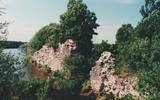
This is one of comparatively few castle hills along the banks of the Daugava River that is not overgrown with trees and bushes, which means that it has a classical castle hill form that is part of the local landscape. The Dignāja castle hill was settled during several periods, particularly between the 5th and the 9th century AD, when it was an important centre. Archaeologists have found that Lettigalian tribes lived here. After the Holy Crusade invasion, the Livonian Order built a castle on the hill that has not survived. It is said that there was once an underground passageway under the hill. The hill itself offers a lovely view of the Daugava River valley. World War I trenches have been preserved the area. There was once a settlement at the foot of the hill. |
|
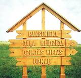 |
„Upmaļi” is the family house of writer Janis Klīdzējs who has written 8 novels, 11 storybooks, 2 essay books
and reflections about Latgalian catholic-Latvian mentality. Janis Streičs (famous Latvian film director) shot a film
based on the novel of Janis Klīdzējs called „The Child of a Man”.
|
|
 |
Swedish scanst (Kuce Hill, Jumprava Hill). Medieval fortification. The monument of national meaning
is located in the village Stari 450 m from Atspuki mill, 70 mto the Southeast from the ruins of Jumpravmuiža.
The territory is 0,7 – 1 m deep outside and 1 – 1,5 m high inside. The new road to the ruins of Jumpravmuiža
leads through the West side of the fortification.
|
|
