
| No | Name | Description |
|---|---|---|
 |
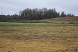
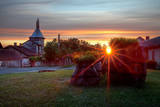
The Cemetery of the Brethren. A wood
pathway leads from the RīgaVentspils highway
(A10) to a memorial rock dedicated to men who
fell during World War II.
|
|
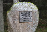 |
Name of Litene is associated with one of the most tragic pages of Latvian history. In twenties and thirties of the 20th century a Latvian Army summer camp was located nearby, where in the summer of 1941 Latvian officers faced the communist terror: Nearly five hundred officers of Latvian army were sent to Norilsk in Siberia, part of them was shot and secretly buried in the nearby forest. At the end of the summer of 1941 about 300 civilians, mostly Jews, were shot there by the army of Nazi Germany. Today, honouring the memory of people killed, memorial and memorial sites are created. |
|
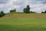 |
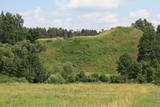
This is one of comparatively few castle hills along the banks of the Daugava River that is not overgrown with trees and bushes, which means that it has a classical castle hill form that is part of the local landscape. The Dignāja castle hill was settled during several periods, particularly between the 5th and the 9th century AD, when it was an important centre. Archaeologists have found that Lettigalian tribes lived here. After the Holy Crusade invasion, the Livonian Order built a castle on the hill that has not survived. It is said that there was once an underground passageway under the hill. The hill itself offers a lovely view of the Daugava River valley. World War I trenches have been preserved the area. There was once a settlement at the foot of the hill. |
|
 |
The Strūves Park is toward the northwest of Jēkabpils, on the left bank of the Daugava, and opposite the Ādamsona (Krustpils) island. The park was established in the 19th century as a place where the city’s residents could relax and hold celebrations. It can be said with absolute certainty that this is a place of global importance, because the park contains a memorial stone to Professor Friedrich Georg Wilhelm Struwe (1793-1864) from the University of Tartu. He was an astronomer and geodesist. The stone is at a place where Struwe completed his land survey of the Vidzeme Province of the Russian Empire. The meridian location which Struwe identified (and other points related to those locations are found in many other European countries) is on the UNESCO list of world heritage. |
|
 |
Lullemē atrodas blakus parka robežai, bet arī šo vietu ir vērts pieminēt kā vienu no apskates objektiem. Lullemē uzmanību piesaista viena otrai blakus stāvošās baznīcas. Mūsdienās redzamās 15. gs. celtās Sv. Marijas baznīcas drupas ir liecinieks 2. pasaules kara notikumiem, kad 1944. g. baznīcu sagrāva. Jaunā baznīca ir celta 1997. gadā. Ciema rietumdaļā uzstādīts piemineklis, kas veltīts brīvības cīņās (1919. – 1920.) kritušajiem. |
|
 |
Atrodas Vārtājas ielejas labajā krastā un labi saskatāms no Priekules – Grobiņas (P106) ceļa. Senās kuršu zemes – Piemares pilskalns, kas vēstures avotos pirmo reizi minēts 1253. gadā – līgumā starp Kurzemes bīskapu un Livonijas ordeni. Viens no lielākajiem Dienvidkurzemes pilskalniem. Iespējams, ka iepriekš – arī sens kulta kalns. Pagājušā gadsimta sešdesmitajos gados veiktajos arheoloģiskajos izrakumos konstatēts, ka pilskalns bijis apdzīvots jau vidējā dzelzs laikmetā. Pie tā konstatēta liela senspilsētas vieta. |
|
|
|
Die Straße führt durch die ehemaligen Fischerdörfer. Eine bessere Radfahr-Alternative auf der Strecke zwischen Häädemeeste und Ainaži. |
|
|
|
The Smārde saloon has a very long history,
and food is served here. There is a car park, and
approx. 100 m to the East is a cemetery and
monument to commemorate soldiers who fell
during World War II.
|
|
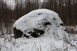 |
The historic stone, on which there is carved over 200 years old boundary-mark, sets the border between the Duchy of Courland and the Russian province. Nowadays, it sets the Babīte and Jelgava district boundary. The stone lies to the East of Kalnciems–Peat road (the south of the swamp Labais purvs) at the edge of a forest firebreak and it can be hard to find. To this end, the description of the road map may help: around 400 m south of the car parking lot at Lily Lake from Kalnciems-Peat road to the right (in the east) turns a forest road which leads down from hills Krāču kalni. It should be around 170 m to go until it abruptly turns to the right (to the southeast). Then you must go in this direction until after ~ 0.5 km to turn to the northeast where after further ~ 0.4 km of the current forest road intersection turn to the north. After ~ 0.4 km turn right (to the east) on a big firebreak, on the left (the north) side of which behind the drainage ditch during the non-leaf period there can be seen a rounded stone. Due to the poor condition of roads, the stone can be reached only on foot. |
|
 |
Swedish scanst (Kuce Hill, Jumprava Hill). Medieval fortification. The monument of national meaning
is located in the village Stari 450 m from Atspuki mill, 70 mto the Southeast from the ruins of Jumpravmuiža.
The territory is 0,7 – 1 m deep outside and 1 – 1,5 m high inside. The new road to the ruins of Jumpravmuiža
leads through the West side of the fortification.
|
|
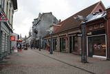 |
Pirmā Liepājas gājēju iela. 140 m garā iela par gājējiem piemērotu tika pārveidota mūzikas festivāla “Mēs Liepājai” (1988. g.) laikā savāktajiem līdzekļiem. Daudzo veikalu un kafejnīcu dēļ iela ir dzīva, tāpēc vietējo iedzīvotāju un viesu iecienīta. |
|
 |
Tiek uzskatīta par vecāko alus darītavu Ziemeļeiropā. Tā tika uzcelta 1878. gadā, un tās pirmais īpašnieks bija grāfs Emanuels fon Zīverss (Sievers), Cēsu pils muižas saimnieks. Savukārt 1922. gadā alus darītavu pārpirka Cēsu uzņēmēji un sāka tur ražot arī vīnu, sulas un minerālūdeni. Uzņēmums "Cēsu alus" šeit alu un atspirdzinošus dzērienus ražoja no 1976. līdz 2001. gadam, bet šobrīd tas ir pārcēlies uz jaunām telpām. Šobrīd ēkā tiek organizētas dažādas izstādes, kā arī ēku var apskatīt no ārpuses. |
|
 |
Located on the left bank of the Venta River 100 m to the Northwest of the Liepāja (A9) highway bridge across the river. The antique castle hill was the site of a Livonian Order that existed from the 14th to the 18th century before being sacked during the Great Northern War. No part of the castle has survived. A stage was built on the castle hill in 1987, and it is a popular venue for various events. The hill is surrounded by a park with wooden chairs that were designed by the sculptor Ģirts Burvis in honour of the kings of Courland. There is a viewing platform, and there are legends about underground passages and a white lady who appears only once every 100 years. |
|
 |
The cosy land road along the sea is 1 km long, and it offers a look at the wonderful aspects of the village. To the right are rocks from the sea, as well as miniature flower gardens on the seashore with tempting benches and overturned boats. On the side of the shore is the Kaltene library, which is more than 100 years ago. It was initially a summer home for Baron Nolken, and it was built in 1899. Later it was rebuilt several times and took on new roles. An elementary school was installed here in 1926, after which it became a club and then, in 1992, a primary school once again. The path runs along beautiful seashore homesteads, among which one can find the former homes of old fishermen and ship builders such as Burliņi. At one time, the Žulnieki portage at Smilgas was the site of the kiln of blacksmith Pēteris Valdemārs. He was the main blacksmith for ships between Kaltene and Upesgrīve. (Source: Roja TIC) |
|
 |
Near Mākoņkalns hill there is a trail that is mowed in the summer and leads to several historical rocks – Plakanais (Flat) rock, Āža muguras (Ram's Back) rock (on which you can clamber), and the Jaunstašuļi Velna pēdas (Devil's Footprint) rock, on the surface of which is a shape similar to a human footprint. There are signs along the side of the road leading to the trail. |
|
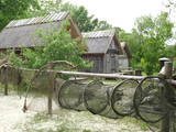 |
This is a very interesting monument to the history of fishing in the region. These areas had docks and areas where fishermen built huts to store their nets and other inventory. The areas also had a social role – men came together to discuss work that had to be done, while women and children wove nets. The huts at Bigauņciems were eventually washed into the sea, and the areas at Ragaciems have been partly destroyed. The ones at Lapmežciems are the ones which are best preserved. One of the net huts has been restored, but the others are in very poor condition, indeed. That may be why you should focus on these huts as you walk along the beach. Make sure that you take some pictures of this historic location. |
|
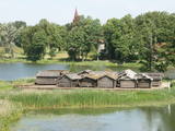 |
The Lake Castle of Āraiši is of pan-European importance. It is a reconstructed Lettigalian lake castle from the 9th or 10th century, and it is the only place in the Baltic States at which visitors can learn about how people lived more than 1,000 years ago. The castle offers various thematic events. |
|
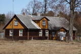 |
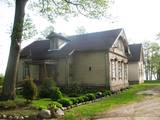
This set of buildings represents a homestead for a fisherman and a farmer. The house was built in 1926, and the ancillary buildings all date back to the first half of the 20th century. The homestead can be seen from the road. |
|
 |
Divas mazas apdzīvotas vietas nacionālā parka dienvidrietumu daļā. No kādreiz piecām Kolski ciema saimniecībām līdz mūsdienām ir saglabājusies tikai viena. Kolski iedzīvotājus līdzīgi kā citviet Baltijas valstīs pēc 2. pasaules kara deportēja uz Sibīriju. Kolski apkārtnē redzamie mājdzīvnieki „apsaimnieko” šejienes pļavas, neļaujot tām aizaugt ar mežu. Tādējādi tiek uzturēta apkaimes vēsturiskā ainava. 3 km dienvidrietumos meklējams Kobasāres ciems. Tā nosaukums (koopa no igauņu valodas nozīmē ala, saar – sala) atgādina par Ziemeļu kara notikumiem, kura laikā cilvēki slēpušies pašu raktās alās. Kobasārē un tam blakus esošajā Apjas (Apja) ciemā var izbaudīt patiesi 21. gadsimtam nepierastas lauku ainavas. |
|
 |
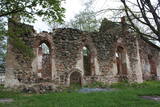
Das alte zemgalicshe wirtschaftspolitische Zentrum, das eine stark befestigte Siedlung vor der Ankunft der Kreuzritter war. Die Ruinen der Burg des Livländischen Ordens. |
|
