
| No | Name | Description |
|---|---|---|
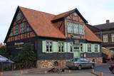 |
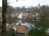
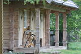
From the historical and architectural perspective, this is an interesting monument to urban construction between the 17th and 19th centuries. Old Liepāja is in the area of the old market and Kuršu Square, where merchants sold their wares beginning in the 1560s. Until 1792, Kuršu Square was also where punishments were implemented. The current Pētertirgus pavilion was installed alongside the square in 1910. A map shows that the network of streets has partly preserved the chaos of street planning that was typical in Medieval towns. |
|
 |
It is believed that at the Kezberkalnins of Limbazi has been Lemisele castle of Metsepole Liv district. It is also found in the reports that merchants travelled to this place from the sea by Svētupe and Dunezers until the 16th century. In 1223 Bishop Albert built a stone castle in Limbazi. Like Valmiera, Limbazi became the member of Hanseatic League. At the beginning of 16th century it economic role declined significantly since Svētupe and Dunezers became unusable for shipping. Between the 16th and 18th centuries, the town and its people suffered from wars, diseases and fires. As a result, the population reached its utmost fall - eight people. In the turn of 19th and 20th century and in the beginning of 20th century the economic life of the town was renewed. |
|
 |
This is one of the oldest Livonian villages, recorded in documents for the first time in 1387. The old road from the Dundaga Estate to Sīkrags existed in the Middle Ages. During the 17th century, Sīkrags was one of the most important small ports in Northern Kurzeme, receiving ships from England, Holland and Lubeck that carried coal, grain and other products. Before World War I, there were five sprat smokehouses in the village, and some 55 fishermen lived there during the 1920s and 1930s. Among those to have been born in Sīkrags was the Livonian cultural activist Hilda Grīva (Cerbaha, 1910-1984), seafaring captain Kārlis Anbanks (1884-1937), Baptist preacher Kārlis Lāceklis (1904-1970), linguist and tradition specialist Pēteris Dambergs (1909-1987), and graphic artist Baiba Damberga (b 1957). Today the village is a cultural monument of national importance. It is crossed by a bike route, with a commemorative stone where the narrow-gauge railroad station once stood. Sīkrags, like neighbouring villages, is in the Slītere National Park. |
|
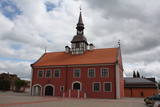 |
In 1615, Courlandian Duke Friedrich Kettler (1569-1642) allowed Bauska to build a new city hall. At the beginning of the 17th century, Market Square in Bauska featured the largest city hall in the entire duchy. A lack of money led to the dismantling of the hall’s tower in 1852 and its second floor in 1871. A new city hall was built in 2011, and now Bauska can be proud of a new and outstanding tourist destination that can also be entered. The restored city hall offers a chance for people to weigh themselves and measure their height with old-time measurements. Each person who does so receives a certificate to attest to his or her height and weight. |
|
 |
The historical centre of Talsi, which is known as the town of nine hillocks. The historical construction around Baznīckalns hill, Lake Talsi and Lake Vilkmuiža mostly dates back to the 19th century. Lielā Street is particularly beautiful with its low-rise buildings (two or three floors and ridged roofs). There are beautiful views from the area around Lake Talsi and Ķēniņkalns hill. |
|
 |
The Capital of Saaremaa island. Popular resort. The Town Hall is built in the style of Baroque. |
|
 |
An ancient territory inhabited by Livs already since the 5th – 6th century. In 1226 Bishop Albert built a castle on the right bank of Salaca river estuary, which has not been preserved until now. Salacgriva development also (similar to Ainazi) has been associated with the establishment of the port in the turn of the 19th – 20th century. Salacgriva became an important handling and transport hubs of products manufactured in Northern Vidzeme (especially timber). During the Soviet period, in the Northern part of Salacgriva established the Fishermen Park with one of the best small town stadiums and open air stage. During that time, the products of fish processing plant "Brīvais vilnis" was well known in the territory of USSR - especially sprats. Salacgriva is one of the two places in Latvia, where the weirs are still used for lamprey fishing. |
|
 |
Dagda is mentioned in the historical sources of 17th century as a trader village. In 1772, Dagda district was included the Pskov province, but in 1802 - Vitebsk province. In 1905 widespread peasant unrest took place here, during which many important architectural monuments were destroyed. Town was not spared also by the two world wars. What's to see for the tourist here? In the centre of Dagda historical buildings - houses, built of red brick - the so-called "Jewish tradesmen houses" are preserved. Dagda is the only place in the Latvia, where every year is celebrated Anne's Day in the town's park! |
|
 |
Ļoti skaists un ainavisks etnogrāfiskais ciems Balošas (Baluošas) ezera ziemeļu krastā, netālu no diviem iepriekš minētajiem ciemiem. Te apskatāmas interesantas un skaistas koka ēkas, kas celtas no guļbaļķiem, ar niedru vai lubiņu jumtiem un izrotātas ar dažāda veida dekoratīvajiem elementiem. Pirmo reizi rakstos Šumini minēti 1784. g. Savu vārdu ciems ieguva no kādreiz dzīvojošas ģimenes uzvārda. Kā interesantākā ir jāpiemin sena klēts. |
|
 |
Dobele name in historical sources for the first time is mentioned in1254. Dobele was one of the most fortified Semigallian places; therefore from 1279 until 1289 it survived six attacks by German crusaders. In 1289 Semigallians was forced to retreat. In 1335 conquerors instead of Semigallian castle began construction of new - stone castle. On the opposite shore of Berze - on the left bank merchants and craftsmen village began to form. Town suffered greatly during the Northern War and during the subsequent plague. A significant event in the economic life was the 1927, when Liepaja-Gludas railway line was built. After World War II in Dobele and its vicinity came to the Soviet militaries, who built one of the largest Soviet tanks range "Dobele-2". Now Dobele travellers are offered a range of interesting sites to be visited. |
|
 |
To the south of Koknese, the Destiny Garden is on an island that is surrounded by the waters of the Pļaviņas hydroelectric power plant (there is a bridge to the shore). The aim of this fundamental open-air object was to commemorate people in Latvia who suffered because of totalitarian regimes. The first work here began in 2008, and the designer of the landscape was a Japanese landscape architect, Shunmyo Masuno. Work on the garden continues, but it is already a popular tourist destination. The first permanent structure is a terrace that offers a view of the Koknese castle ruins and the local Lutheran church. This means that there will be something new each time that people visit the park. People are invited to bring rocks for this nationally important location that commemorates Latvia’s history. |
|
 |
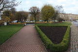
Madonas centrālais laukums, kas vēl 20. gs. sākumā bija tirgus laukums. Pēc apjomīgās restaurācijas tas ir kļuvis par ievērības cienīgu pilsētvides objektu. Laukuma ziemeļu pusē atrodas pilsētas un novada pašvaldība un Madonas novada TIC. |
|
 |
Haapsalu was once loved by aristocrats who stayed here during summers, nowadays this town is very appealing to its visitors because of its essence - tiny streets, old wooden buildings and promenade. Worth mentioning are also town's SPAs which were one of the reasons why Haapsalu was so popular its earlier years. Interesting enough, the famous composer Tchaikovsky considered this place one of his favorite's for spending the holidays. |
|
 |
Истоки площади Роз уходят в 1911 - 1913 гг., когда на этом месте разбили открытый сад с > 500 кустами роз. В советское время рядом с площадью Роз был установлен памятник Ленину. Восстановленную в 2000 году площадь окружает Лиепайская Педагогическая академия, гостиница «Лива», Центр бизнеса и сделок De Rome (построен в XIX веке, архитектор Пауль Макс Берчи, бывшая гостиница «Рим») и Лиепайский дом латышского общества (камень в основание заложил Карлис Ульманис в 1934 г.). По бордюрам грядок роз размещены памятные знаки городов содружества Лиепаи. К площади Роз подходит улица Зивью (Рыбная), получившая свое название от когда-то существовавшего рыбного рынка. На улице Зивью находится Аллея славы латвийских музыкантов (с 2006 г.), где установлено 35 плит с бронзовым рельефом ладоней музыкантов, 10 плит, посвященные популярным латвийским музыкальным группам, а 5 – ушедшим в мир иной. Здесь же установлена самая большая гитара Латвии. |
|
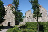 |
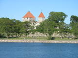
Exploring of Sigulda can be started with a visit to Sigulda castle ruins. The construction of the castle was begun by the Knights of the Sword Order in 1207, but in 1236 it was rebuilt for the needs of the Livonian Order. Sigulda castle suffered much from the wars in the second half of the 16th century and in the beginning of 17th century. During the Northern War, it is burned down and is no more restored. Today south-western building of the convent and the tower of the main gate, behind which is the inner forefront of the castle with open air stage, which offers impressive views over the Gauja valley. Currently the reconstruction of castle ruins is in progress. Construction of New castle (owner - Prince Kropotkin) in the South of the Sigulda took place from the 1878 until 1881. From 1923 - 1940 the building was the Palace of Writers, but during the Soviet years - Cardiology sanatorium. Since 2003 Sigulda district council is located there. The manor complex includes wooden house (middle of 19th century), which was Kropotkin's family home, barn (turn of the 18th - 19th century), gardener's house (19th century) and a stone fencing (19th century.) If we make our way from New Castle in a north-eastern direction, after almost 2 km we will reach Vejupite ravine. There you can see the shallow (3.6 m) but high (6.1 m) in Peter's Cave and deep Pucu ravine with Krauklupite. At the conjunction of ravines of both streams rises a Satezele hill fort (plateau 90 x 75 m), where in the beginning of 13th century was the oak castle of Liv land chief (eldest) - Dabrelis. Near can be found Krauklu gorge - ravine of Vejupite left bank, with 11 m high sandstone walls and 5.2 m deep Krauklu cave. At the conjunction of Vejupite ravine and Gauja valley columns Paradise (Gleznotaju) Hill - a very picturesque place, painted and photographed since old times! The Paradise Hill can be reached with a electric vehicle. In the west part of Sigulda is located Ferris wheel (works during the summer) and Air cableway (streetcar) - the only this type of vehicle in Baltics (built in the 1969). Its self-supporting cable extends in 1060 m length and without any support joins the Gauja River valley banks between Sigulda and Krimulda ~ 40 m above Gauja River. Here you can enjoy excellent views! In the south-western part of Sigulda one can walk to mighty Beites precipice, which is split by the deep ravine of stream. On the west side of the ravine lies Keizarskats, which is located ~ 67 m above the Gauja level and offers good views of Krimulda and Turaida castle. Sight place was arranged here already in the 1862 when Russian Tsar Alexander II visited Sigulda. In the eastern part of the ravine wooden Keizarkrēsls (Emperor Stool) is located. |
|
 |
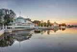
Ap 200 m garajā un izstieptās formas laukumā no 16. – 20. gs. atradās Liepājas tirgus. Laukuma malās tolaik bija izveidojusies vienstāvu apbūve – iebraucamās sētas, viesnīcas un dārzi. Līdz ar Pētertirgus izveidi 1910. gadā, izmainījās arī laukuma apveidi un to ieskaujošā apbūve. Laukuma DA malā slejas iespaidīgā Liepājas Svētās Annas Luterāņu baznīca. |
|
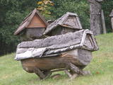 |
Das bekannteste Museum der Geschichte der Bienenzucht Litauens mit den Bienenhäusern verschidener Arte, der Arbeitsmittel der Bienenzüchter, Holzskulpturen und Hönigankauf. |
|
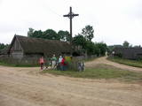 |
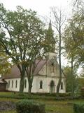
Ein der ethnografischen Dörfer in Dzūkija mit Holzgebäuden und Kruzifix. |
|
 |
The city of wind, amber and musicians. In the literature sources Liepaja was mentioned for the first time in 1253. The city strived as a trade harbour already at the end of the 16th century. Especially important was the ruling period of Kurzeme Dukes Jacob and Friedrich, when the export and import of Lithuania and Kurzeme goods was provided through Liepaja harbour. Instead of the Līva River that was filled with dune sand a channel was excavated and wharf was formed. The growth of the city continued in the 18th century also after the Northern War and the plague epidemic. When in 1795 Kurzeme was added to the Russian Empire, as one of the most important western harbours of the Empire the harbour of Liepaja developed even more rapidly. From the end of the 18th century until the 19th century Liepaja also became a popular recreation place for the aristocrats of Petersburg. At the end of the 19th century the construction works of War Port and fortress begun. The city became a military strategic place. It suffered hard during World War II. In 1967 the sea trade harbour terminated its operation in Liepaja and Liepaja became a closed city where the War Port was "a city within a city". Today the War Port and its offer is one of the top tourism spots in Latvia. |
|
 |
Apdzīvota vieta ~ 1 km dienvidos no Daugavpils – Krāslavas (A 6) ceļa, kas pazīstama ar savu neparasto nosaukumu. Interesanti, ka vietvārds saistīts arī ar iedzīvotāju uzvārdiem, ko var redzēt tāda paša nosaukuma kapos. Ciema apkaimē pazīstams ir Lielo Muļķu svētavots, kuru gan nezinātājam ir grūti atrast, tādēļ ieteicams izmantot vietējā gida pakalpojumus, apvienojot šīs vietas izziņu ar biškopības saimniecības „Cīruļi” apskati. |
|
