
| No | Name | Description |
|---|---|---|
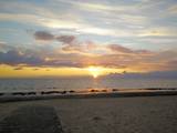 |
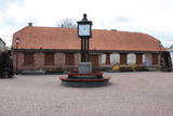
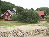
The largest town in the region dates back to the 19th century, when three local fishing villages – Neibāde, Pēterupe and Katrīnbāde – became a popular location for leisure and swimming. This led to the construction of many summer homes, and the development of the spa was facilitated by the opening of a rail line between Rīga and Saulkrasti in 1905. New spas and restaurants were opened, and the spa infrastructure was developed. During the summer there were various entertainments, including balls and concerts featuring orchestras from Rīga. Also facilitating the development of the spa was a road and railroad line between Rīga and Saulkrasti that were installed during the 1930s. During the Soviet occupation, leisure homes, sanatoriums and new summer homes were built in Saulkrasti, which was given the status of a city. Today Saulkrasti is attractive because of its white sand beach, as well as various annual events, the Saulriets trail, the White Dune, the unique bicycle museum, Sea Park, the “Centrs” swimming facility, Sun Square, etc. |
|
 |
Saldus is mentioned in the historical documents already in 1253. Until the 13th century an ancient Cours castle Salden was located here, which is also represented in the coat of arms of the town. Around the 1341 Livonian Order built a castle near the Cours hill fort, where settlement formed. Its peak of development, like the other settlements of Courland, was during the reign of Duke Jacob 1642 – 1682. 1856 is mentioned as the year of the foundation of Saldus, when restoration of town perished during the Northern War begun. At the end of the World War II a big fights took place at the town, but town remained in German-occupied part of Latvian until the May 8, 1945. Modern Saldus attracts with its activities - town days, the music festival "Saldus Saule", as well as a variety of sightseeing objects, among which A/S 'Druvas Partika" can be mentioned, where you can watch how the ice cream is made and Saldus Food Factory, where you can taste the delicious candy "Gotina" and watch the production process. |
|
 |
Dobele name in historical sources for the first time is mentioned in1254. Dobele was one of the most fortified Semigallian places; therefore from 1279 until 1289 it survived six attacks by German crusaders. In 1289 Semigallians was forced to retreat. In 1335 conquerors instead of Semigallian castle began construction of new - stone castle. On the opposite shore of Berze - on the left bank merchants and craftsmen village began to form. Town suffered greatly during the Northern War and during the subsequent plague. A significant event in the economic life was the 1927, when Liepaja-Gludas railway line was built. After World War II in Dobele and its vicinity came to the Soviet militaries, who built one of the largest Soviet tanks range "Dobele-2". Now Dobele travellers are offered a range of interesting sites to be visited. |
|
 |
This location is important in terms of Latvia’s history, because during the 12th and 13th century, this was the administrative and spiritual centre of the Lettigalian tribe, with the ruler of Jersika being Visvaldis. The castle stood on the shore of the Daugava at a height of 18 m, and this was a mighty castle hill. The flat part of the hill measured 100 x 75 m, and it was surrounded by a barrier and a defensive wall made of logs. People entered the castle via guarded gates beyond which there were residential and household buildings, as well as a small church. Archaeologists have found the remnants of log buildings, as well as many antiquities from the 10th to the 13th century that speak to extensive trade relations with other parts of Europe, including ancient Russia. In 1209, the forces of Bishop Albert fooled the people in the castle and sacked it and the ancient town that was around it. Visvaldis’ family was taken hostage, and so the Lettigalian ruler was forced to become a vassal of the bishop. The castle hill is privately owned, so please contact the owner before planning a visit. |
|
 |
Eine Floßhauptstadt Lettlands mit dem jährlichen Flößerfest im Mai. |
|
|
|
A small town on the way from Riga to Bauska. Town's name is first mentioned in written sources in 1492. Here you can see Lutheran Church and former Manor Park |
|
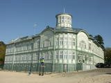 |
Jurmala town (the second largest in Latvia) was founded in 1959, by combining Kemeri and Sloka towns in the Riga city Jurmala district. It stretches 32 km along the coastal line of Gulf of Riga. Jurmala resort once was one of the most important objects of this type in the Northern Europe. This was facilitated by the development of local and interstate transport and traffic (coaches, steamers, train). The first guests was accommodated in Dubulti, where in 1834 the first hotel was built, but in 1847 - The first wellness centre. In the 19th the first medical institution launched. Starting from 1834 the rapid construction of summer cottages began. Development of the resort was ended by the World War I. After the war the number of resort vacationers boomed from 12 thousand (in 1920) to 32 thousand (in 1935). Kemeri resort developed along with Jurmala, which received a massive of vacationers' amount during the Soviet period. |
|
 |
Der älteste und größte Kurort Litauens (seit 1794). Mikroklima (Luft der Umgebungswälder), salzhaltigee Quellen, Heilschlamm. Die Altstadt ist ein städtebauliches Denkmal. |
|
 |
This is an ancient populated area. There were 50 homesteads here during the 1930s, with only ten remaining in 1990. The Livonian scholar and entomologist Kārlis Princis (1893-1978) was born in Oviši. In 1944, he emigrated to Sweden. The Oviši lighthouse (1814) is 38 metres high and is the oldest functioning lighthouse in Latvia. There are lovely views from the top of the lighthouse. The building in which employees of the lighthouse used to live was erected in 1905 and has been preserved. A narrow-gauge train station was in the building at one time. The Oviši Lighthouse Museum is nearby, as is the metal Tree of Austra. Opposite Cape Oviši is a great place for bird watching. |
|
 |
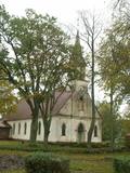
The Lutheran Church of Krimulda is considered one of the oldest churches in Latvia. It was originally built in the 13th century, soon after the conquest of Kubesele and later rebuilt many times. Near the church a meditation labyrinth "Lily Flower" is set up. When Liv chief Kaupo fell during the battle at Viljandi in 1217, according to the legend, the ash was buried at the church. A small hill adjacent to Runtinupite (Runtins) is popularly known as a grave site of Kaupo, at its right bank is located ~7 m long, artificially dug Kubesele or Runtin cave. On the left bank of Runtinupite columns the Kubesele hill fort. Kubesele nature trail starts at the church. This trail leads to the Gauja River, where the Great (Runtina) stone lies. Here can be seen anchor pads installed by Gauja raftsmen. Krimulda medieval castle (4 km east of Krimulda Church) was built the second half of the 13th century in the place where the right bank of Gauja valley is split by deep ravine of Vikmeste. Castle (residence of Riga dome capitol - Riga's Archbishop Council) was an imposing building, whose big inner yard was included by 1.5 m thick defensive wall. In 1601, while retreating, Swedish military leader Heinrich Lieven blasted Krimulda castle. Now at the hill fort, grown with the forest a small castle ruins can be seen. Nearby is located air cableway and starts Krimulda mountain road. Located nearby Krimulda manor was first mentioned in writings in the 15th century. Present manor castle was built in the 19th century in neoclassical style (owner - First Lieven). During the twenties of the 20th century, the castle after its alienation became a property of the Latvian Red Cross, which established here children's sanatorium. Nowadays the castle houses rehabilitation hospital "Krimulda", but from the farm buildings, manor stables, barn, servant, manager houses and the so-called Swiss Cottage and Park have been preserved. Thematic tours are offered here. If we go down the Gauja by boat, then we will be able to take a close look at about 15 m high Velnalas cliffs. They can be well seen also from the opposite - left bank of Gauja (resting place is established). In the middle of the cliff about 19 m deep and 4.7 m high Krimulda Velnala cave is located. If we go from the Velnala cave cliffs along the lower part of the right bank of Gauja in Turaida direction, you will see Pikenes cliff, rich with sandstone outcrops. At its foot ~ 1 km long Pikenes beaver trail is established. The Little Devil's Cave (5 m long) is on the side of the trail, with the Gudribas (Wisdom) spring that springs out of the cave, as well as Aunapieres cave which is the same length as Devils cave. Small oxbow lakes also can be seen. |
|
|
|
This village is at the place where the Irbe (Dižirve, Īra) River flows into the sea, and it is on both shores of the river (sea side and land side). The name of Irbe was recorded for the first time in a 1310 border agreement between the bishop of Kurzeme and the Rīga Dome Capitol. The name of Lielirbe (Irvemūnde) was recorded for the first time in a document from an arbitration court in 1387. At the end of the 19th century, the small port at Lielirbe was an active centre for the sale and transport of timber materials. In the late 19th and early 20th centuries, the largest number of sailing ships among villages on the western shore of Kurzeme was built there. In 1939, the village had some 300 residents, more than 70 houses and a Baptist church which is now at the Ventspils Open Air Museum. A narrow-gauge railroad passed through the village, which had a post and telegraph office, two grocery stores, an elementary school, a choir and a brass band. Lielirbe was one of the largest villages to disappear after World War II. Cultural historian Valda Marija Šuvcāne (1923-2007) was born in Lielirbe, and her daughter, Baiba Šuvcāne, is continuing her mother's work by writing important papers about life along the Livonian coastline. By 2019, a bridge is to be reinstalled across the Irbe River. |
|
 |
Ventspils Vecpilsētas vēsturiskais centrs. Nelielā Rātslaukuma (40 x 60 m) rietumu malā atrodas Starptautiskā rakstnieku un tulkotāju māja, kas ierīkota 18. gs. dzīvojamā ēkā ar baroka un klasicisma iezīmēm (19. gs. vidū te atradās pilsētas Rātsnams), bet austrumu malā – vēlīnā klasicisma stilā celtā evaņģēliski luteriskā Nikolaja baznīca. Iepretim baznīcai atrodas modernā stilā pārbūvētā Ventspils Galvenā bibliotēka un Digitālais centrs, kas ierīkots greznā 19. gs. savrupmājā. |
|
 |
An ancient territory inhabited by Livs already since the 5th – 6th century. In 1226 Bishop Albert built a castle on the right bank of Salaca river estuary, which has not been preserved until now. Salacgriva development also (similar to Ainazi) has been associated with the establishment of the port in the turn of the 19th – 20th century. Salacgriva became an important handling and transport hubs of products manufactured in Northern Vidzeme (especially timber). During the Soviet period, in the Northern part of Salacgriva established the Fishermen Park with one of the best small town stadiums and open air stage. During that time, the products of fish processing plant "Brīvais vilnis" was well known in the territory of USSR - especially sprats. Salacgriva is one of the two places in Latvia, where the weirs are still used for lamprey fishing. |
|
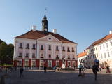 |
Formed on the left side of river Emajõgi, in the valley of Doma Hill. The centre of The Old Town of Tartu is Town Hall Square with Town Hall and the fountain "The Kiss of the Students" (symbol of the city). |
|
 |
Ap 200 m garajā un izstieptās formas laukumā no 16. – 20. gs. atradās Liepājas tirgus. Laukuma malās tolaik bija izveidojusies vienstāvu apbūve – iebraucamās sētas, viesnīcas un dārzi. Līdz ar Pētertirgus izveidi 1910. gadā, izmainījās arī laukuma apveidi un to ieskaujošā apbūve. Laukuma DA malā slejas iespaidīgā Liepājas Svētās Annas Luterāņu baznīca. |
|
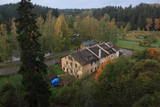 |
The history of Līgatne cannot be separated from the paper factory which was once the only factory of its kind in Latvia. Tours are available in the company of a guide. During the late 19th and early 20th century, the company built homes, a school, a birthing centre, a hospital, a club, a guesthouse and other buildings for its employees, and most of these buildings have survived to this day. There are more than 200 interesting underground passageways which are still used as warehouses for various items, including vegetables. |
|
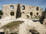 |
The ruins of the Koknese Castle are found where the Daugava and Pērse rivers flow together. The castle, which is on a floodplain, was built for the bishopric of Rīga in 1209, and it replaced an ancient Latvian castle that was made of wood. The castle was blown up by Saxon forces in 1701. A visitors centre is near the ruins, and there you can carve a Medieval coin or rent a boat to sail down the Daugava. Make sure to stroll through the Koknese park, which is alongside the ruins. |
|
 |
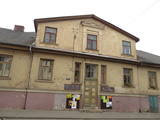
This is an urban construction monument that was created between the 17th and 19th century, and it is of national importance. The street layout around Jelgavas and Rātūža streets forms closed blocks of buildings. There are Lutheran, Catholic, Orthodox and Baptist churches in Jaunjelgava. One of the most outstanding architectural monuments is City Hall, which was built in 1912 and features Art Nouveau forms. None of the city’s five synagogues has survived. The historical centre of Jaunjelgava features a promenade that runs along the banks of the Daugava River. This is a popular place for strolls, leisure and swimming. |
|
 |
Located in the northern part of Valmiera, the Valmiermuiža Estate mansion (Neo-Baroque Style) was built between 1764 and 1771 by Prince August Friedrich of Schleswig, Holstein and Soderburg. Over the course of time it has been owned by other people. According to modern evidence, the mansion was a one-story building with a Baroque tower and a two-story addition in the early 20th century, which made it appropriate as a summer home and hunting lodge. The building burned down in 1918. Two years later, Valmiermuiža became a prison camp for captured soldiers. Later the addition to the mansion was restored and used as an elementary school. In 1936, the building became a prison, and it was once again a prison camp for captured soldiers during World War II. Later the building burned down again, and the ruins were removed. Still surviving is the Valmiermuiža tower, with ceiling paintings that are a cultural monument, as is the surrounding park. The Valmiermuiža brewery is alongside the historical monument, thus providing second wind for the whole region. |
|
 |
Ein ehemaliges Fischerdorf am Ufer des Kurischen Haffs. Hierher sind die Bewohner der Dörfern umgezogen, deren Dörfe unter dem Sand der Wanderdünen begraben wurden. Holzbebauung des 19 – 20 Jh. |
|
