
Dabas objekti Igaunijā

Ar ko ievērojama daba Igaunijā?
Iespaidīgākā Baltijas klinšu siena – t.s. Ziemeļigaunijas glints, „Līču zeme” – Lahemā ar nacionālo parku, „Salu zeme” – Sāremā sala un Monzunda salu arhipelāgs, Matsalu līcis kā viena no nozīmīgākajām masveida putnu atpūtas vietām migrāciju laikā, viens no izcilākajiem Eiropas meteorīta krāteriem, izcilākie Baltijas dižakmeņi un ūdenskritumi, Munameģis – Baltijas augstākā virsotne, Peipuss – piektais lielākais Eiropas ezers – ar senām zivju ieguves tradīcijām un ārkārtīgi lielā dabas daudzveidība, kas ir acīmredzami mainīga gan austrumu – rietumu, gan ziemeļu – dienvidu virzienā, ir tikai dažas no Igaunijas valsts dabas pievilcībām.
Lai uzzinātu vairāk par apmeklējamām teritorijām aicinām izmantot vides vai vietējo gidu pakalpojumus. Esiet saudzīgi pret dabu ceļojuma laikā - ievērojiet Zaļos padomus!
| Pārskats | Detaļas |
|---|---|
 |
Igaunija
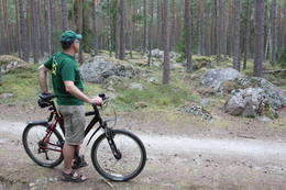
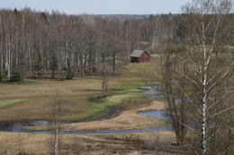
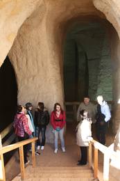
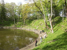
Kesmu pussala (Käsmu poolsaar)Ar skujkoku mežiem klāta pussala – piemērota vieta kājāmiešanai un braucieniem ar divriteni. Te izveidots velomaršruts, kas no Kesmu ciema (Käsmu küla) aizved līdz Kesmu ezeram (Käsmu järv) un tālāk gar pussalas rietumu uz ziemeļu piekrasti aizlokas atpakaļ līdz minētajam ciemam. Tas gan nav domāts iesācējiem, jo vietām ceļi ir smilšaini, bet krasta ceļš var būt aizgāzts ar kritušiem kokiem. Kesmu pussalas ziemeļu daļā atrodas izcilais Kesmu akmeņu lauks (Käsmu kivikülv). Lielākais no akmeņiem ir Matsikivi akmens (tilpums -132,9 m3). Ziemeļos no Kesmu ciema jūras krastā uzmeklējams iespaidīgu akmeņu „bariņš” Iespaidīgākais no tiem ir Vecā Jura akmens (Vana Jüri kivi), kura augstums ir 5,5 m, bet tilpums - 102,9 m3. Piemērotos laika apstākļos (g.k. vasarās) pa akmeņainu strēli var aiziet vai aizbrist līdz ~ puskilometru attālajai Sārtnēmes (Saartneem) saliņai. Atpakaļceļā uz ciemu var atstāt savu akmeni „Laimes akmeņu kaudzē”. Kesmu ziemeļdaļas apskatei izveidots 4,5 km garš kājnieku tūrisma maršruts. Kesmu kapteiņu ciemā (Käsmu kapteniküla) 1804. g. nodibināja pirmo Igaunijas jūrskolu un laikā no 1798. – 1920. g. uzbūvēja > 40 kuģus. Atrodamas ziņas, ka no nedaudz vairāk par 100 no šeit kādreiz dzīvojošajām ģimenēm ir nākuši 62 kapteiņi. Bijušā jūrskolas ēkā izveidots Jūrniecības muzejs. Netālu apskatāma Kesmu kapela.  81 81
Pakalpojumi
81km - Attālums no valsts galvaspilsētas |
 |
Igaunija
Tuhalas dabas centrs un Raganas aka (Nõiakaev)Tuhalas apkārtne ir apdzīvota vismaz 3000 gadus. Šeit ir atrastas 11 senas apmetnes, 30 kulta akmeņi, 3 akmens senkapi, 4 svētbirzes u.c. Tuhalas lieguma teritorijā atrodas unikālā Nõiakaev (Raganas aka), kas palu laikā “vārās” un izmet 100 litrus ūdens sekundē, kā arī pieci Igaunijas spēcīgākie enerģijas stabi. Pa pastaigu ceļu, kas šķērso Tuhalas karsta procesu teritoriju (2,5 km), var iet kājām, vai braukt ar velosipēdu un automobili. Šis ceļš ir piemērots pastaigām kopā ar ģimeni. 32
 1-12 1-12
Pakalpojumi
32km - Attālums no valsts galvaspilsētas
1-12 Aktīvie sezonas mēneši |
 |
Igaunija
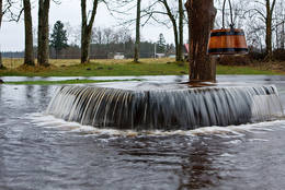
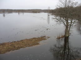
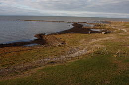
Leti tornis (Läti torn)Jēsū – Kepu ceļa malā pie Leti (Läti) ciema ir izveidots autostāvlaukums ar putnu vērošanas torni, no kura paveras skats uz Hallistes upes palieņu pļavām un tuvējā ciema apkārtni. Stipru palu laikā arī no šī torņa redzamā apkārtne (izņemot ceļus) var atrasties zem ūdens. Laba putnu vērošanas vieta. Läti tulkojumā no igauņu valodas nozīmē Latvija. |
 |
Igaunija
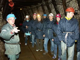
Degslāneklis jeb degakmensDegslānekli – Igaunijas enerģētikas un ķīmiskās rūpniecības galveno izejvielu mūsdienās iegūst atklātos karjeros vai pazemes šahtās. Šis nogulumiezis sācis veidoties Ordovika periodā (pirms ~ 450 - 480 mlj. g.) no tā laika augu un dzīvnieku atliekām. Kohtla – Nõmme piepilsētā vienā no izstrādātajām šahtām gida pavadībā var aplūkot gan šo nogulumiezi (Baltijas valstīs atradnes tikai Igaunijā), gan arī iepazīt tā ieguves veidus un vēsturi.
PakalpojumiPakalpojumi - atpūta
Dabas vērošanaSavukārt, Kivieli (Kiviõli) ciemā var uzkāpt Vecajā degakmens izdedžu kalnā (Vana tuhamägi), no kura paveras viena no savdabīgākajām Igaunijas ainavām. Informācija: www.kivioli.ee |
 |
Igaunija
Otepää augstieneViena no trijām Dienvidigaunijas augstienēm ar ainaviskiem pauguriem un skaistām skatu vietām. Tās „centrā” iegūlis līčiem bagātais Pühajärv ezers (tulkojumā – Svētezers). 230
Pakalpojumi
230km - Attālums no valsts galvaspilsētas |
 |
Igaunija
Saleveres Salumegi kalns (Salevere Salumägi)Litorīnas jūras laikā (pirms ~ 6000 gadiem) Saleveres Salumegi kalns bija sala, bet mūsdienās tas kā izteikta kāple (īpaši - ziemeļu pusē) paceļas virs Piejūras līdzenuma. Salumegi ziemeļu pusē slejas 4 - 5 metrus augsts kaļķakmens atsegums – silūra perioda (> 400 mlj. gadu) koraļļu rifa paliekas, kuru noskalojuši Litorīnas jūras viļņi. Atseguma piekājē izplūst Acu avots, kam piedēvē dziednieciskas īpašības. Salumegi apskates nolūkos izveidota lokveida taka (1,5 km). No kalna augšas paveras labs skats uz Matsalu līci. Šeit atradies arī sens pilskalns. 132
Pakalpojumi
132km - Attālums no valsts galvaspilsētas |
 |
Igaunija
Perajerva meža taka (Pärajärve metsarada)Četrus kilometrus gara marķēta lokveida taka, kas ved pa lielāku meža masīvu, iepazīstina ne tikai ar augiem un dzīvniekiem, bet arī mežsaimniecības tradīcijām. Takas sākums atrodas pie nelielā Perejerves ciema, uz kuru paveras labs skats no tuvējā paugura. Pie autostāvlaukuma izveidota atpūtas un piknika vieta. |
 |
Igaunija
Pakri salasDivas salas – Lielā Pakri (Suur Pakri) un Mazā Pakri (Väike Pakri) - 3 km R no Paldiskiem (Paldiski). Padomju laikā tās izmantoja kā armijas aviācijas poligonu, par ko liecina daudzās bumbu bedres un munīcijas paliekas. Salas klāj g.k. retas kadiķu audzes, bet to Z, ZA galos paceļas iespaidīgas līdz 6 m augstas kaļķakmens klintis.
|
 |
Igaunija
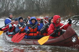
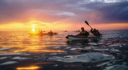
Piedzīvojumi 360°Uzņēmums nodarbojas ar dabas tūrisma pasākumu organizēšanu: vasarā laivošana ar kajakiem jūrā, rudenī – pārgājieni ar sniega kurpēm pa purvu, ziemā – pārgājieni ar sniega kurpēm, un pavasarī – laivošana ar kanoe laivām pa upēm. Dabas draugiem piedāvā tematiskas ekskursijas: pavasarī – lāču vērošanas safari un putnu vērošana, rudenī – aļņiem, roņiem un vilkiem veltīti tematiskie pasākumi. 37
1-12
Pakalpojumi
37km - Attālums no valsts galvaspilsētas
1-12 Aktīvie sezonas mēneši |
 |
Igaunija
Putnu vērošanas tornis Puises ragāPuises ragā (Puise nina) ir uzcelts divstāvīgs atpūtas nams, kas apvienots ar putnu vērošanas torni. No tā paveras skats uz piekrasti, kas ir iecienīta migrējošo zosu atpūtas vieta. Šī ir privāta teritorija, kuras apskati vēlams saskaņot ar īpašnieku. 123
Pakalpojumi
123km - Attālums no valsts galvaspilsētas |
 |
Igaunija
Gaujas kultūras mantojuma taka (Koiva pärandkultuuri rada)2010. gada rudenī tapa 60 km garā velotaka, kas iepazīstina ar Igaunijas un Latvijas kultūras mantojuma objektiem, kas sastopami Gaujas kā valstu robežupes krastos. Taka sākas no Tellingumē stāvvietas. Tās abos galos un robežas šķērsošanas vietā ir iekārtotas atpūtas vietas un izlikti informācijas stendi ar trases shēmu. Nenomaldīties palīdz norādes. 267
1-12
Pakalpojumi
267km - Attālums no valsts galvaspilsētas
1-12 Aktīvie sezonas mēneši |
 |
Igaunija
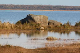
Nēri akmeņi (Näärikivid)Trīs lielāka izmēra laukakmeņi – aizsargājami dabas pieminekļi, kas atrodas Matsalu līča krastā starp Sāstnas (Saastna) un Metskjulas (Metsküla) ciemiem. Tuvējā ceļa malā ir izvietots informācijas stends un norādes, bet līdz akmeņiem var nokļūt pa iezīmētu taku. Pēc kāda tautas nostāsta, lielas vētras laikā, kas notikusi Jaungada naktī, lielais akmens sašķēlies trīs daļās. No tā arī cēlies vietvārds. Apkārtnē redzamās pļavas ir nozīmīga daudzu augu sugu dzīves vide un svarīga putnu ligzdošanas un atpūtas vieta. Šī iemesla dēļ taku drīkst apmeklēt tikai no 1. jūlija līdz septembra beigām. Akmeņi ir arī labi redzami no minētā ceļa. Tie ar ledāju atceļojuši no Turku (Somija) apkārtnes. 129
Pakalpojumi
129km - Attālums no valsts galvaspilsētas |
 |
Igaunija
Meža večas ģimenes parks (Metsamoori Perepark)Meža večas ģimenes parks izveidojies starp Kaikas kupolveidīgajiem pauguriem, un sastāv no vairākām viensētām, kas piedāvā uzzināt par dabai tuvu, veselīgu dzīvesveidu un tautas medicīnu. Katrai viensētai ir sagatavota sava programma, kur apmeklētāji var iepazīties ar ārstniecības augiem, ārstēšanu ar dēlēm, bišu un sēņu noslēpumaino pasauli, izjust buramvārdu un meditāciju vietu ietekmi uz sevi. Te māca gatavot ēdienus no nezālēm, cept maizi un taisīt garšaugu maisījumus. Ar viensētām var iepazīties arī individuālie apmeklētāji. 275
5-9
Pakalpojumi
275km - Attālums no valsts galvaspilsētas
5-9 Aktīvie sezonas mēneši |
 |
Igaunija
Oksas (Oksa) takaBijušā piecstāvīgā metāla skatu torņa apkaimē plešas Lemmjegi upes palieņu pļavas. Netālu atrodas kādreizējā Oksas kroga (Oksa kõrts) vieta, kur saglabājies iespaidīgs manteļskurstenis. Apkaimes apskatei izveidota 0,8 km gara koka laipu taka. 175
Pakalpojumi
175km - Attālums no valsts galvaspilsētas |
 |
Igaunija
Voremā drumlinu lauksTabivere ciems. Drumlinus veidojis ledājs un tie orientēti ledāja kustības virzienā. Pēc izskata drumlini atgādina klaipveida paugurus. No to „mugurām” paveras skaisti skati uz drumlinu lauka ainavu un ieplakās esošajiem ezeriem. Apmeklētāju centrs atrodas Äksi ciemā.
|
 |
Igaunija
Penijē tornis (Penijõe torn)Lai nokļūtu līdz šim tornim, ir jāveic apmēram 20 – 30 min ilgs pārgājiens pa dabas taku no Penijē muižas gar Penijegi (Penijõgi) kreiso krastu. Te redzami bebru darbi un to celtās zaru mājas. No torņa paveras skats uz Kazari deltu, kas dabā izpaužas kā monolīts un nepārskatāms niedrājs. To vairākās daļās sadala Kazari un mazāka izmēra upītes. Katrai deltas daļai ir savs vēsturiskais nosaukums: no torņa pa kreisi no Penijegi redzama Lihula meri (Lihulas „jūra”), bet tās labajā pusē - Kloostri meri (Klostri „jūra”). Putnu vērotāji var iziet garāku (7 km) dabas takas loku, kas ved pa palieņu pļavām. Jārēķinās, ka pavasaros būs nepieciešami piemēroti apavi! Pļavas ierobežotās platībās apsaimnieko mājdzīvnieki, tādēļ neaizmirstiet aizvērt vārtiņus aiz sevis un netraucējiet to ikdienas gaitas! No maršruta nav atļauts novirzīties, lai netraucētu putnus. |
 |
Igaunija
Ērdi taka (Öördi rada)1,2 km gara taka, kas pa purvainu mežu aizved līdz Ērdi purvam (Öördi raba) un tā austrumu daļā esošajam Ērdi ezeram (Öördi järv), pie kura izveidota atpūtas un peldvieta. |
 |
Igaunija
Piusas upes senleja un Piusas alas~ 15 km garš Piusas senlejas posms starp Vana - Vastseliina un Ignasõ ciemiem, kur upei novērojams liels kritums, ātras straujteces un skaisti Devona perioda smilšakmens atsegumi, no kuriem Hermas siena (Härma müür) ir augstākais (ar senlejas nogāzi – 43 m) smilšakmens atsegums Igaunijā. Piusas ciemā atrodas Piusas raktuvju alas. Tikai pavisam neliela daļa no > 10 km garās Piusas raktuvju sistēmas ir eksponētas un labiekārtotas kā apskates objekts.
PakalpojumiPakalpojumi - atpūta
Izbraukumi ar kuģīti/laivuIzbraukums ar laivu pa Vana - Vastseliina - Ignasõ (1 diena, ekstrēms, tikai palu laikā). Informācija: www.piusa.ee. 
Dabas takaPārgājiens gar upi visā senlejas garumā (~ 20 km). |
 |
Igaunija
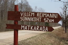
Paunas taka (Pauna rada)Kultūrvēsturiska taka (garums ~ 2 km) Tipu (Tipu) ciemā, kas iepazīstina ar vairākiem interesantiem objektiem: veco skolu (1931. g.), Hallistes upi, pirti un Paunas saimniecību, kurā dzimis viens no Igaunijas nacionālās kustības līderiem Villems Reimans (1861. – 1917.). |
 |
Igaunija
Suitsu tornis (Suitsu torn)Suitsu tornis celts 1979. g. kā pirmais Matsalu rezervāta metāla tornis. To atjaunoja 1998. g. Torņa augstums ir 21 m, tādēļ no tā paveras izcila dabas un kultūrainava uz Kazari deltas niedrājiem un blakus esošo Suitsu upi (Suitsu jõgi), kuras krastā ir uzceltas vairākas zvejnieku laivu būdas. |
 |
Igaunija
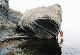
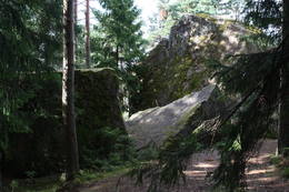
Tammispeas akmens (Tammispea kivi)Tikpat iespaidīgs, taču ne tik populārs tūrisma objekts kā netālu esošais Jāņa – Toma akmens. Tammispeas akmens iegūlis mežā, tāda paša nosaukuma nelielā ciemā, kas atrodas Eru līča (Eru laht) dienvidu krastā. Tilpuma ziņā (262 m3) – 16. lielākais Igaunijas dižakmens. Tā garums ir 10,7 m, platums – 6,5 m, augstums – 7,5 m, bet apkārtmērs – 27,8 m. Iespaidīgas ir arī šī akmens atlūzas. Ar šī akmens attēlu noteikti ir jāpapildina sava lielāko Baltijas dižakmeņu fotokolekcija. 70
Pakalpojumi
70km - Attālums no valsts galvaspilsētas |
 |
Igaunija
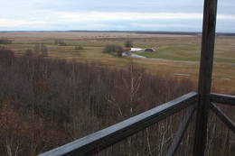
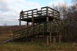
Mēkonnu skatu tornis (Mäekonnu vaatetorn)Viens no diviem nacionālā parka skatu torņiem, kas atrodas ~ 1,5 km ziemeļos no Ehijerva ezera (Ähijärv). Tornis ir veiksmīgi „nomaskēts” nelielā priežu pudurī, tādēļ tas „nebojā” izcilo dabas un kultūrainavu, kas paveras no tā skatu platformas. Pie autostāvlaukuma ir izveidota labiekārtota atpūtas vieta. |
 |
Igaunija
Reimana CeļojumiUzņēmums nodarbojas ar dabas tūrisma pasākumu organizēšanu: agrā pavasarī – izbraucieni ar plostiem, vasarā – laivošana ar smailēm (kopā ar bebru dzīves vērošanu), visu gadu – pārgājieni ar sniega kurpēm pa Igaunijas augstajiem un zemajiem purviem, ziemā – izbraucieni ar stumjamām ragaviņām. Pieredzējuši pārgājienu vadītāji pastāstīs interesantus notikumus un faktus par Igaunijas dabu un kultūru. 34
1-12
Pakalpojumi
34km - Attālums no valsts galvaspilsētas
1-12 Aktīvie sezonas mēneši |
 |
Igaunija
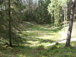
Ilumetsas meteorīta krāteriTrīs krāteri, no kuriem lielākā – Elles kapa (Põrguhaud) diametrs ir ~ 80 m, dziļums līdz 12 m. To ietver vairākus metrus augsti vaļņi. Pārējie krāteri ir dabā grūti atrodami un atpazīstami. Krāteru vecums ir ~ 6000 gadi. Līdz šim gan nav atrastas meteorīta atliekas, kas apstiprinātu to izcelsmi.
PakalpojumiPakalpojumi - atpūta
Dabas taka0,7 km gara taka līdz Põrguhaud krāterim. Informācija: http://www.ut.ee/BGGM/vaatamis/ilumetsa.html. |
 |
Igaunija
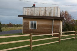
Skatu platforma Puises ciemāPuises „centrā” uz vienstāvu koka mājiņas jumta izveidota skatu platforma. No tās paveras laba ainava uz ciemu, ostu un piekrastes kadiķu laukiem. 121
Pakalpojumi
121km - Attālums no valsts galvaspilsētas |
 |
Igaunija
Rannajē putnu vērošanas tornis (Rannajõe linnutorn)Divstāvīgs skatu tornis pie Laikjula (Laiküla) – Hāpsalu ceļa, no kuras paveras plaša ainava uz Matsalu līcī ietekošo upīšu palieņu pļavām. Te var vērot migrējošās dzērves un zosis, bet pavasaros varbūt laimēsies redzēt vai dzirdēt ķikutu Gallinago media. Viens no retajiem torņiem, kas ir pielāgots cilvēkiem ar īpašām vajadzībām. |
|
|
Igaunija
Lemmjē pārgājienu taka (Lemmjõe matkarada)Taka, kas izveidota Lemmjegi (Lemmjõgi) un Raudnas (Raudna jõgi) satekas vietā, iepazīstina ar palieņu pļavām un veciem pārmitriem mežiem, kas ir vieni no lielākajiem Igaunijā. Takas sākumā dominē atklātas lauku ainavas. Viens no 4,9 km garās lokveida takas apskates objektiem ir Lemjē dižozols. Mitrā laikā noderēs ūdensizturīgi apavi. 155
Pakalpojumi
155km - Attālums no valsts galvaspilsētas |
 |
Igaunija
Saaremaa salaLielākā Igaunijas jūras sala. Tulkojumā – „Salu zeme”. Ar Muhu salu to savieno 3 km garš dambis – tilts, pa kuru var braukt velosipēdisti. 160
Pakalpojumi
160km - Attālums no valsts galvaspilsētas |
 |
Igaunija
Ehijervs (Ähijärv)Karulas nacionālā parka lielākais ezers - 2,8 km garš, līdz 1 km plats. Ezera ziemeļaustrumu krastā atrodas parka apmeklētāju centrs. 5,5 m dziļais ezers ir gan zivīm, gan nostāstiem bagāta vieta. Ezera un tuvākās apkārtnes iepazīšanas nolūkā ir izveidota 3,5 km garā Ehijerva taka (Ähijärve teerada). Tās sākums atrodas pie iepriekš minētā apmeklētāju centra, kur izveidota atpūtas vieta un atraktīvs bērnu spēļu laukums. Taka sākumā ved gar ezera krastu, nelieliem mitrājiem un meža ceļiem, kas izmantoti iepriekšējos gadsimtos. |
 |
Igaunija
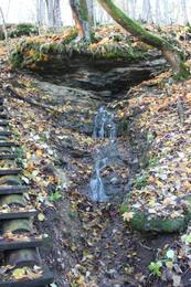
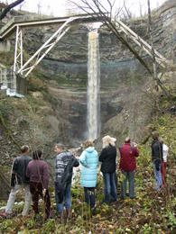
Sakas – Ontikas – Toilas klintsKlinšainā vairākpakāpju kāple - t.s. Ziemeļigaunijas glints, kas ar pārtraukumiem stiepjas gar Igaunijas Somu līča piekrasti (ieskaitot arī dažas salas), ir viena no iespaidīgākajām Baltijas reljefa formām. Tās ģeoloģiski un ainaviski izteiksmīgākais posms ir Sakas – Ontikas – Toilas klints, kas ~ 22 km garumā veido neparastu dabas vidi ar maksimāli 53 m augstu atsegumu kompleksu un mazskartu meža masīvu tā nogāzēs, kur redzami Kembrija un Ordovika perioda nogulumieži – māli, smilšakmens, kaļķakmens u.c. Pie Valastes pāri klintij traucas līdz 24 m augstais Valastes ūdenskritums (Valaste juga). Īpaši iespaidīgs ūdenskrituma kanjons ar leduskritumiem izskatās pēc ilgāka sala! Sezonāli ūdenskritumi (8 – 10 m augsti) ir meklējami arī pie Ontikas un Toilas ciemiem.
|


