
| Nr | Name | Beschreibung |
|---|---|---|
 |
The breeding of Californian red snails and production of bio-humus. You are offered a short excursion around the production, information about breeding snails and the production of bio-humus. |
|
 |
Atrodas Amatas ielejas augstajā krastā, autoceļa (A 2) Rīga – Veclaicene malā. Plašs ēdienu klāsts, lielas porcijas, iecienīta tālbraucēju šoferu maltītes ieturēšanas vieta. |
|
 |
Briežuciems, kas atrodas Balvu novadā, ir izveidojies pēc 2. Pasaules kara kā padomju saimniecības „Briežuciems” centrālais ciemats. Mūsdienās Briežuciema amatu meistaru ciems ir vieta, kur tiek kopti un godāti tradicionālie amati, iesaistot tos mūsdienu dzīvē. |
|
 2 Tagen
|
Die sagenhaften Blauen Berge von Šlītere sind schon seit alten Zeiten bekannt, als Seeräuber dort betrügerische Feuer gemacht haben, damit die Seeleute mit ihren Schiffen auf die Sandbänke des Kaps von Kolka fahren. Heute nennt man die Küste des Nationalparks Slītere bildlich als das Freilichtmuseum für Geologie der Ostsee, weil man hier das ehemalige Ufer des Baltischen Eisstausees, des Ancylussees und Dünenbildungen (Kangari, Vigas) besichtigen kann, die deutlich die Entwicklungsgeschichte der Ostsee zeigen. Dieses Gebiet haben früher die Liven bewohnt, deren Fischerdörfer als der Ort der Kultur einer der kleinsten ethischen Gruppe der Welt bedeutend sind. Die Route führt auf der Strecke von Kolka bis Mazirbe auf der alten Küstenstraße, die sich durch die Dörfer der Liven windet. Der Nationalpark Slītere ist eines der pflanzenreichten Gebiete Lettlands, aber das Kap von Kolka – einer der bekanntesten Orte zur Vogelbeobachtung. Route information from Latvijas Lauku forums |
|
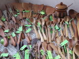 |
The spoon workshop offers useful objects such as wooden spoons, cutting boards, butter knives, pans, spatulas, etc. You can produce your own wooden spoon and look at finished spoons made of more than 17 different types of wood from Latvia. During the summer the owners offer “pancake tours” with tasty jams. You can purchase spoons and homemade wine. |
|
 12 Tagen
|
Dauer: 9 Tage / 12 Tage, für wen: unabhängige Individualreisende. Transport: Fahrrad, Kanu, gesamtlänge - ~ 446 km Radfahren, ~ 7 km im Kanu. Reiseverlauf: Riga - Gauja-Nationalpark - Otepää - Ahja-Fluss - Tartu - Lahemaa-Nationalpark - Tallinn |
|
 |
Die Gaststätte Raudnaela befindet sich am Rande der Autobahn Pärnu–Tartu, an der Stelle des ehemaligen Gasthauses Raudna (18. Jh.), 15 Autominuten entfernt von Viljandi. Die Gäste können das leckere hausgemachte Essen genießen, hier werden auch thematische Abendessen veranstaltet. |
|
 |
Radošajā galerijā var apskatīt vairākas ekspozīciju zāles ar skulptūrām no moto/auto detaļām, individuāli pārveidotiem motocikliem, kuriem ir savs stāsts un filozofija. Latvijā vienīgais ar šādu mākslu un piedāvājumu saistīts uzņēmums. Apmeklētājiem ir iespēja doties nelielā ekskursijā, galerijas apskatē ar gidu. Pēc apmeklējuma ir iespēja doties uz kafejnīcu, kurā var nobaudīt kafiju un mājās ražotus kulinārijas izstrādājumus, arī noskatīties dažādas video īsfilmas par uzņēmuma darbību. Pieejama unikālo NESTER CUSTOM suvenīru iegāde. |
|
 |
Im Zentrum dieses Schutzgebietes befindet sich der eutrophische See Tosmare, eine ehemalige Lagune des Litorina – Meeres. Der See und seine Umgebung bietet vielen Pflanzen und Vögeln Schutz. Am südlichen Ende des Sees kann man Überreste des ehemaligen Befestigungssystems von Liepāja entdecken, nach Westen hin befindet sich einer der wichtigsten Teile des Systems – der Festungskanal.
|
|
 |
Restaurant Ankur ist ein gemütlicher Ort, an dem hausgemachte Speisen aus hauptsächlich örtlichen Produkten angeboten werden. Besonders beliebt ist der Fisch aus dem Peipussee. Im demselben Gebäude befindet sich auch ein Hotel. |
|
 |
In der Zauberküche werden leckere Speisen aus den in der Gegend angebauten Produkten angeboten. Sie sollen unbedingt die Brennesselsuppe kosten, die als die beste südestnische Suppe gilt. Nõiariik ist für die aktive Erholung sowohl für Familien als auch für größere Gruppen geeignet. |
|
|
|
Latvijas Valsts mežu laivu bāzē, kas atrodas Kaņiera ezera dienviddaļā (redzama no Lapmežciema – Antiņciema ceļa) kopā ar laivu bāzes ēku apvienots skatu tornis, no kura lieliski pārredzama ezera austrumdaļa. |
|
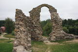 |
Am rechten Ufer des Flusses Rēzekne befand sich in 9 – 12 Jh. eine alte lettgalische Burg, an deren Stelle hat 1285 der Livländische Orden angefangen, eine zweistöckige Steinburg zu bauen. Nabenan befindet sich das Zentrum der kreativen Dienstleistungen in Ostlettland und das Tourismusinformationszentrum. Entlang der Promenade des Flusses Rēzekne kann man bis zur 500 m weit gelegenen vor kurzem gebauten Konzerthalle GORS (Geist) gehen, die sich durch die moderne Architektur auszeichnet. |
|
 |
Die Molkerei von Talsi wurde 1922 bei dem Zusammenschluss einiger anderen Molkereien gegründet. Später entstand auf dieser Basis die “Talsu piensaimnieks” AG. Eins der bekanntesten Produkte des Betriebs ist der Käse "Talsu ritulis" (der Käselaib von Talsi). Die Produktion von der “Talsu piensaimnieks” AG – Milch, Kefir, Quark, Butter, Käse u.a. kann man in einem zum Betrieb nahegelegenen Geschäft „Piena sēta” kaufen. |
|
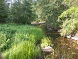 |
Ein ausgeprägtes Gebiet des unteren Flusslaufes der Vitrupe mit kleinen Sandsteinfelsen und vielen seltenen Arten von Pflanzen und Mollusken. Besucher können das Ķirbiži – Waldmuseum besuchen mit Informations- und botanischen Pfad. Dieser schlängelt sich an beiden Flussufern entlang und erlaubt den Besuchern, die typischsten Vertreter der Pflanzenwelt der Region zu betrachten. Die prächtige Vāloži – Eiche stellt bildet hier den Schwerpunkt.
|
|
 |
Es ist eines der seltenen Angebote in der Region Latgale, wo der Reiseleiter während der Führung in der lettgallischen Mundart singt. Es ist eine fesselnde und attraktive Erzählung über historische Ereignisse, die mit dem Landgut von Preiļi und mit dieser Stadt verbunden sind. |
|
 |
Das einzige Milchverarbeitungsunternehmen in Lettland, das Rohmilchkäse "Tējas" mit verschiedenen Geschmäcken herstellt. Das Unternehmer stellt auch geräucherten Wurstkäse, Käse für Salate und süßes Quarkriegel "Gardumiņš", sowie andere Milchprodukte her. Die Erzeugnisse kann man auf dem Markt in Daugavpils, auf dem Rigaer Zentralmakrt, sowie an den allen Handlungsorten des Unternehmens "Latgales piens" in Lettland kaufen. |
|
 |
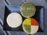
In the workshop it is possible to learn about the process of creating and the usage of pottery of different historic periods, as well as other household goods. Archaeological pottery is presented. The Middle Ages man-carried clay bread oven, frying-pan, drinking cups, the pilgrims’ water bowls. All the works are handmade in the moulded ceramics style and burned in the clay kiln. |
|
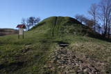 |
Arī Senču pilskalns, Baznīckalns un Velna gulta. Pirmo reizi minēts 1230. gadā kā viens no senās kuršu zemes Vanemas centriem. Ar šo objektu var sākt Abavas senlejas skaistāko skatu apzināšanu. Līdz pilskalna plakumam ved kāpnes, un no tā redzami senlejas vārti un upes ielejas kreisā krasta nogāze, kuras piekājē izvietojusies Jaunkandava.
|
|
 6 Tagen
|
Die Tour führt durch Nationalparks und Naturschutzgebiete von internationaler Bedeutung entlang der Küste. Unterwegs werden kleine reizvolle Städte, einige historische Sehenswürdigkeiten und traditionelle Dörfer besucht. Auf der Tour erkunden Sie seltene und geschützte Pflanzen und örtliche Traditionen, sowie genießen wunderbare Landschaften, die Wildnis und Einsamkeit. Im Nationalpark Kemeri gehen Sie auf einem Pfad im Moor, sehen wilde Wiesen und können einen Vogelbeobachtungsturm neben dem See Kanieris besteigen. Danach erkunden wir den Naturpark des Sees Engure, wo man 22 Orchideenarten finden kann. Am nächsten Tag führt die Tour Richtung den Nationalpark Slitere, der das ehemalige Gebiet des Baltischen Eisstausees und des Littorina Meeres ist. Sie besuchen den Kiefernpfad des Kaps von Kolka und den Pfad des Sees Peterezers, in dessen Landschaft man die Bildungsperioden der Ostsee sehen kann. Weiter führt die Tour zum Pfad des Moores Stikli, das das größte Moorgebiet in Lettland ist. In Uzava entdecken Sie die größte graue Düne in den baltischen Staaten und die wilden Ufer des Flusses Venta, aber danach – die reizvolle Stadt Kuldiga, die mit ihrer gut erhaltenen hölzernen Architektur und dem breitesten Wasserfall in Europa bekannt ist. Weiter führt die Tour durch das Urstromtal Abava, das von tauenden uralten Eismassen gebildet worden ist. In Sabile können Sie an dem berühmten Weinberg halten, der der nördlichste Weinberg der Welt ist, und an dem Pflanzenpfad von Sabile, aber weiter auf der Tour – an der größten Eiche in Europa. Auf dem Weg nach Riga unternehmen Sie eine Wanderung auf dem 5 km langen Pfad des Moores von Cena, das Nieder-, Hoch- und Übergangsmoore, sowie die dort waschenden Pflanzen charakterisieren. |
|


